
Cologne (Köln), by Georg Braun and Frans Hogenberg. 1575

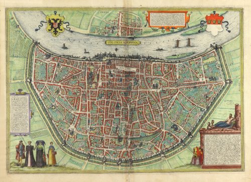
TRANSLATION OF CARTOUCHE TOP: Divitense Munimentum is today known in the corrupted form of Tuitum and in popular speech as Deutz. Constantine the Great, son of Emperor Constantius, built the fortress for soldiers to be garrisoned here and protected from Gaul; hence their unit was named Divitenses milites (Ammianus Marcellinus mentions them in Book XXVI). Deutz is famed in our times for its magnificent Benedictine abbey. St Rupert, a native German philosopher, rhetorician, poet, astronomer and most industrious theologian, excelled here in 1124 with the composition of many books.
CARTOUCHE BOTTOM LEFT: Concerning the bridge and insignia of the city of Cologne: in c. AD 310 M. Flavius Valerius Constantinus Maximus, son of Emperor Constantius, built in Cologne as a sign of state sovereignty and to embellish the border of the Empire, a stone bridge whose construction was difficult but which was intended and required as a permanent protection against the Franks advancing towards Gaul. Around 962, however, Bruno, the archbishop of Cologne and brother of Emperor Otto I, had this bridge pulled down so that it would not be open to the Franks from the west. The insigna of this most prosperous city shows a silver-coloured shield whose upper part (called the fetial or, in the common tongue, the head) bears three gold crowns in a row on a red ground. These were adopted in place of three priest's caps in 1162 after the relics of the Magi were brought to Cologne. The regalia of the city are naturally characterized first and foremost by the jus apprehensionis and the claves portarum. [...]
CARTOUCHE BOTTOM RIGHT: The God of the Rhine. Cologne, a large, flourishing and magnificent city, the head and metropolis of Lower or Second Germany, was initially an Ubii settlement. [...] Near the south lies the town of Bonn, and to the north, Neuss on the banks of the Rhine [...]. Owing to its position on the Rhine, the number and splendour of its churches, its large population spread across 23 city districts, and thanks to its highly regarded council, its clergy and university, Cologne is widely known and famed. Like Rome, it has St Peter as its patron saint. It is governed by Italian law. Cologne holds first place in the general assembly of the imperial cities. Within the famous Hanseatic League of 72 cities, Cologne is numbered amongst the leaders. It also maintains a permanent alliance with the Belgian and Burgundian nation. Finally, as a mighty city, it is a welcome and intended safe and fortified seat for the Elector of the Holy Roman Empire, the archbishop.
COMMENTARY BY BRAUN (on verso): "Cologne is a large and famous city in Germany this side of the Rhine. It is known firstly for its church of unsurpassable size, the cathedral. It is built with wonderful art high into the sky out of stone hewn in a spirited manner and is dedicated to St Peter the Apostle. [...] The town hall of this city is particularly finely decorated; it has a tall and skilfully executed tower of ashlars and stones dressed with the aid of a level. The top of the town hall has many windows from which you can look out over the whole city. To the east, where the town hall faces the Alter Markt, is a beautiful gallery and a pretty clock."
The author's home, Georg Braun, and the birthplace of his city atlas is seen in a bird's-eye view from a steep angle. The plan illustrates Cologne's large surface area and characteristic semicircular ground plan fronting the Rhine. Thanks to the captions, the most important buildings can be easily identified. To the left of the centre, the cathedral - the largest Gothic church in Germany, with towers 157 m in height - appears in distorted perspective. To its right lies the town hall described by Braun, together with the Alter Markt and the Heumarkt. Prominent in the lower half of the map is the Romanesque basilica of the Holy Apostles. A significant city since Roman times, in 1288, Cologne became an imperial city. Close trading links with England encouraged its rapid economic growth, and the Cologne exchange was founded in 1553. The crowded clocks illustrate the city's lively commercial traffic. From 1388 onwards, the town was also the seat of a university, the first in the German-speaking territory to have been founded on a town council initiative. The Braun-Hogenberg map of Cologne was created specifically for the atlas. It is one of the city's most valuable and accurate plans as it stood in the 16th century when it was home to 40,000 inhabitants. (Taschen)
Braun G. & Hogenberg F. and the Civitates Orbis Terrarum.
The Civitates Orbis Terrarum, also known as the 'Braun & Hogenberg', is a six-volume town atlas and the most excellent book of town views and plans ever published: 363 engravings, sometimes beautifully coloured. It was one of the best-selling works in the last quarter of the 16th century. Georg Braun, a skilled writer, wrote the text accompanying the plans and views on the verso. Many plates were engraved after the original drawings of a professional artist, Joris Hoefnagel (1542-1600). The first volume was published in Latin in 1572 and the sixth in 1617. Frans Hogenberg, a talented engraver, created the tables for volumes I through IV, and Simon van den Neuwel made those for volumes V and VI. Other contributors were cartographers Daniel Freese and Heinrich Rantzau, who provided valuable geographical information. Works by Jacob van Deventer, Sebastian Münster, and Johannes Stumpf were also used as references. Translations appeared in German and French, making the atlas accessible to a broader audience.
Since its original publication of volume 1 in 1572, the Civitates Orbis Terrarum has left an indelible mark on the history of cartography. Seven more editions followed the first volume in 1575, 1577, 1582, 1588, 1593, 1599, and 1612. Vol.2, initially released in 1575, saw subsequent editions in 1597 and 1612. The subsequent volumes, each a treasure trove of historical insights, graced the world in 1581, 1588, 1593, 1599, and 1606. The German translation of the first volume, a testament to its widespread appeal, debuted in 1574, followed by the French edition in 1575.
Several printers were involved: Theodor Graminaeus, Heinrich von Aich, Gottfried von Kempen, Johannis Sinniger, Bertram Buchholtz, and Peter von Brachel, all of whom worked in Cologne.
Georg Braun (1541-1622)
Georg Braun, the author of the text accompanying the plans and views in the Civitates Orbis Terrarum, was born in Cologne in 1541. After his studies in Cologne, he entered the Jesuit Order as a novice, indicating his commitment to learning and intellectual pursuits. In 1561, he obtained his bachelor's degree; in 1562, he received his Magister Artium, further demonstrating his academic achievements. Although he left the Jesuit Order, he continued his studies in theology, gaining a licentiate in theology. His theological background likely influenced the content and tone of the text in the Civitates Orbis Terrarum, adding a unique perspective to the work.
Frans Hogenberg (1535-1590)
Frans Hogenberg was a Flemish and German painter, engraver, and mapmaker. He was born in Mechelen as the son of Nicolaas Hogenberg.
By the end of the 1560s, Frans Hogenberg was employed upon Abraham Ortelius's Theatrum Orbis Terrarum, published in 1570; he is named an engraver of numerous maps. In 1568, he was banned from Antwerp by the Duke of Alva and travelled to London, where he stayed a few years before emigrating to Cologne. He immediately embarked on his two most important works, the Civitates, published in 1572 and the Geschichtsblätter, which appeared in several series from 1569 until about 1587.
Thanks to large-scale projects like the Geschichtsblätter and the Civitates, Hogenberg's social circumstances improved with each passing year. He died as a wealthy man in Cologne in 1590.
Colonia Agrippina Urbs Ampla ... Inferioris, Sine Secundae Germaniae Caput et Metropolis.
Item Number: 29417 Authenticity Guarantee
Category: Antique maps > Europe > Germany - Cities
Old, antique bird’s-eye view plan of Cologne (Köln), by Georg Braun and Frans Hogenberg.
Title: Colonia Agrippina Urbs Ampla ... Inferioris, Sine Secundae Germaniae Caput et Metropolis
Oriented to the east.
Date of the first edition: 1572.
Date of this map: 1575.
Copper engraving, printed on paper.
Map size: 330 x 480mm (12.99 x 18.9 inches).
Sheet size: 400 x 520mm (15.75 x 20.47 inches).
Verso: Latin text.
Condition: Original coloured, browning along centrefold.
Condition Rating: A.
From: Civitates Orbis Terrarum, Liber Primus. Antwerp, Gilles van den Rade, 1575. (Van der Krogt 4, 41:1.1)
TRANSLATION OF CARTOUCHE TOP: Divitense Munimentum is today known in the corrupted form of Tuitum and in popular speech as Deutz. Constantine the Great, son of Emperor Constantius, built the fortress for soldiers to be garrisoned here and protected from Gaul; hence their unit was named Divitenses milites (Ammianus Marcellinus mentions them in Book XXVI). Deutz is famed in our times for its magnificent Benedictine abbey. St Rupert, a native German philosopher, rhetorician, poet, astronomer and most industrious theologian, excelled here in 1124 with the composition of many books.
CARTOUCHE BOTTOM LEFT: Concerning the bridge and insignia of the city of Cologne: in c. AD 310 M. Flavius Valerius Constantinus Maximus, son of Emperor Constantius, built in Cologne as a sign of state sovereignty and to embellish the border of the Empire, a stone bridge whose construction was difficult but which was intended and required as a permanent protection against the Franks advancing towards Gaul. Around 962, however, Bruno, the archbishop of Cologne and brother of Emperor Otto I, had this bridge pulled down so that it would not be open to the Franks from the west. The insigna of this most prosperous city shows a silver-coloured shield whose upper part (called the fetial or, in the common tongue, the head) bears three gold crowns in a row on a red ground. These were adopted in place of three priest's caps in 1162 after the relics of the Magi were brought to Cologne. The regalia of the city are naturally characterized first and foremost by the jus apprehensionis and the claves portarum. [...]
CARTOUCHE BOTTOM RIGHT: The God of the Rhine. Cologne, a large, flourishing and magnificent city, the head and metropolis of Lower or Second Germany, was initially an Ubii settlement. [...] Near the south lies the town of Bonn, and to the north, Neuss on the banks of the Rhine [...]. Owing to its position on the Rhine, the number and splendour of its churches, its large population spread across 23 city districts, and thanks to its highly regarded council, its clergy and university, Cologne is widely known and famed. Like Rome, it has St Peter as its patron saint. It is governed by Italian law. Cologne holds first place in the general assembly of the imperial cities. Within the famous Hanseatic League of 72 cities, Cologne is numbered amongst the leaders. It also maintains a permanent alliance with the Belgian and Burgundian nation. Finally, as a mighty city, it is a welcome and intended safe and fortified seat for the Elector of the Holy Roman Empire, the archbishop.
COMMENTARY BY BRAUN (on verso): "Cologne is a large and famous city in Germany this side of the Rhine. It is known firstly for its church of unsurpassable size, the cathedral. It is built with wonderful art high into the sky out of stone hewn in a spirited manner and is dedicated to St Peter the Apostle. [...] The town hall of this city is particularly finely decorated; it has a tall and skilfully executed tower of ashlars and stones dressed with the aid of a level. The top of the town hall has many windows from which you can look out over the whole city. To the east, where the town hall faces the Alter Markt, is a beautiful gallery and a pretty clock."
The author's home, Georg Braun, and the birthplace of his city atlas is seen in a bird's-eye view from a steep angle. The plan illustrates Cologne's large surface area and characteristic semicircular ground plan fronting the Rhine. Thanks to the captions, the most important buildings can be easily identified. To the left of the centre, the cathedral - the largest Gothic church in Germany, with towers 157 m in height - appears in distorted perspective. To its right lies the town hall described by Braun, together with the Alter Markt and the Heumarkt. Prominent in the lower half of the map is the Romanesque basilica of the Holy Apostles. A significant city since Roman times, in 1288, Cologne became an imperial city. Close trading links with England encouraged its rapid economic growth, and the Cologne exchange was founded in 1553. The crowded clocks illustrate the city's lively commercial traffic. From 1388 onwards, the town was also the seat of a university, the first in the German-speaking territory to have been founded on a town council initiative. The Braun-Hogenberg map of Cologne was created specifically for the atlas. It is one of the city's most valuable and accurate plans as it stood in the 16th century when it was home to 40,000 inhabitants. (Taschen)
Braun G. & Hogenberg F. and the Civitates Orbis Terrarum.
The Civitates Orbis Terrarum, also known as the 'Braun & Hogenberg', is a six-volume town atlas and the most excellent book of town views and plans ever published: 363 engravings, sometimes beautifully coloured. It was one of the best-selling works in the last quarter of the 16th century. Georg Braun, a skilled writer, wrote the text accompanying the plans and views on the verso. Many plates were engraved after the original drawings of a professional artist, Joris Hoefnagel (1542-1600). The first volume was published in Latin in 1572 and the sixth in 1617. Frans Hogenberg, a talented engraver, created the tables for volumes I through IV, and Simon van den Neuwel made those for volumes V and VI. Other contributors were cartographers Daniel Freese and Heinrich Rantzau, who provided valuable geographical information. Works by Jacob van Deventer, Sebastian Münster, and Johannes Stumpf were also used as references. Translations appeared in German and French, making the atlas accessible to a broader audience.
Since its original publication of volume 1 in 1572, the Civitates Orbis Terrarum has left an indelible mark on the history of cartography. Seven more editions followed the first volume in 1575, 1577, 1582, 1588, 1593, 1599, and 1612. Vol.2, initially released in 1575, saw subsequent editions in 1597 and 1612. The subsequent volumes, each a treasure trove of historical insights, graced the world in 1581, 1588, 1593, 1599, and 1606. The German translation of the first volume, a testament to its widespread appeal, debuted in 1574, followed by the French edition in 1575.
Several printers were involved: Theodor Graminaeus, Heinrich von Aich, Gottfried von Kempen, Johannis Sinniger, Bertram Buchholtz, and Peter von Brachel, all of whom worked in Cologne.
Georg Braun (1541-1622)
Georg Braun, the author of the text accompanying the plans and views in the Civitates Orbis Terrarum, was born in Cologne in 1541. After his studies in Cologne, he entered the Jesuit Order as a novice, indicating his commitment to learning and intellectual pursuits. In 1561, he obtained his bachelor's degree; in 1562, he received his Magister Artium, further demonstrating his academic achievements. Although he left the Jesuit Order, he continued his studies in theology, gaining a licentiate in theology. His theological background likely influenced the content and tone of the text in the Civitates Orbis Terrarum, adding a unique perspective to the work.
Frans Hogenberg (1535-1590)
Frans Hogenberg was a Flemish and German painter, engraver, and mapmaker. He was born in Mechelen as the son of Nicolaas Hogenberg.
By the end of the 1560s, Frans Hogenberg was employed upon Abraham Ortelius's Theatrum Orbis Terrarum, published in 1570; he is named an engraver of numerous maps. In 1568, he was banned from Antwerp by the Duke of Alva and travelled to London, where he stayed a few years before emigrating to Cologne. He immediately embarked on his two most important works, the Civitates, published in 1572 and the Geschichtsblätter, which appeared in several series from 1569 until about 1587.
Thanks to large-scale projects like the Geschichtsblätter and the Civitates, Hogenberg's social circumstances improved with each passing year. He died as a wealthy man in Cologne in 1590.
Related items

Colonia [on verso:] Augusta 1493
Cologne and Augsburg (recto-verso), by Hartmann Schedel.
[Item number: 2964]

Colonia. 1493
Cologne (Köln), by Hartmann Schedel.
[Item number: 10231]

Coloniensis Archiepiscopatus. 1647-50
Cologne (Köln), by Willem Blaeu.
[Item number: 19075]

Profil de la Ville Archiepiscopale et Electorale de Colongne Agripine. 1648
Cologne (Köln) by J. Boisseau
[Item number: 25621]

Cölln. 1658/60
Panoramic view of Köln (Cologne), by N. Visscher & P.H. Schut.
[Item number: 26645]
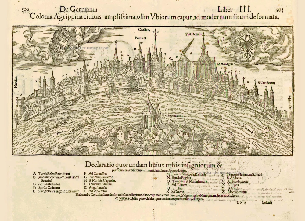
Colonia Agrippina civitas amplissima, olim Ubiorum caput, ad modernum situm deformata. 1552
Cologne (Köln) by Sebastian Münster
[Item number: 27406]

Unrecorded variant of Schut's view of Cologne (Köln), by Carel Allard
CÖLLN. 1673
View of Cologne (Köln) by Carel Allard.
[Item number: 30553]

Archevesché et Eslectorat de Cologne avec ses Enclaves dans les Pays Circomvoisins. 1692
Cologne (Köln) by N. Sanson, so-called published by Hubert Jaillot. (Pirated edition by Pierre Mortier).
[Item number: 31405]

Cölln. 1686
Köln (Cologne) by Christoph Riegel.
[Item number: 31704]

L'Archevesche de Coulongne. 1633
Cologne (Köln) by Christophe Tassin.
[Item number: 31936]