
Cologne (Köln) by Christophe Tassin. 1633

Tassin Christophe Nicolas. (? - 1660)
Christophe Tassin was a French cartographer known for his atlases of France, Spain, Germany, and Switzerland.
He was 'Ingenieur-géographe du roi'. He used this title only between 1633 and 1638. In 1633 Tassin published an atlas of France and Spain, Cartes générales des provinces de France et d’ Espagne; one of Germany, Cartes généralis des royaumes et provinces de la haute et basse Allemagna; and one of the Low Countries, Plans et profils des principales villes du duché de Lorraine, avec les cartes generale et particulieres de chacun gouvernement d’iucelles.
In 1644, Tassin ended his work and sold his copper plates of maps to Antoine de Fer, who published them in many subsequent editions.
L'Archevesche de Coulongne.
Item Number: 31936 Authenticity Guarantee
Category: Antique maps > Europe > Germany
Cologne (Köln) by Christophe Tassin.
Title: L'Archevesche de Coulongne.
Date of the first edition: 1633.
Date of this map: 1633.
Copper engraving, printed on paper.
Image size: 105 x 150mm (4¼ x 6 inches).
Sheet size: 155 x 195mm (6 x 7¾ inches).
Verso: Blank.
Condition: Excellent.
Condition Rating: A+.
From: Tassin C. Cartes Generales des Royaumes et Provinces de la Haute et Basse Allemagne. Reveues, corrigées & augmentées par le sieur Tassin Geographe ordinaire de sa Majesté. A Paris, Chez Martin Gobert au Palais en la gallerie des prisonniers. M.DC.XXXIII. (1633). (Pastoureau, p. 445, Tassin IV Aa 1633)
Tassin Christophe Nicolas. (? - 1660)
Christophe Tassin was a French cartographer known for his atlases of France, Spain, Germany, and Switzerland.
He was 'Ingenieur-géographe du roi'. He used this title only between 1633 and 1638. In 1633 Tassin published an atlas of France and Spain, Cartes générales des provinces de France et d’ Espagne; one of Germany, Cartes généralis des royaumes et provinces de la haute et basse Allemagna; and one of the Low Countries, Plans et profils des principales villes du duché de Lorraine, avec les cartes generale et particulieres de chacun gouvernement d’iucelles.
In 1644, Tassin ended his work and sold his copper plates of maps to Antoine de Fer, who published them in many subsequent editions.
Related items

Colonia [on verso:] Augusta 1493
Cologne and Augsburg (recto-verso), by Hartmann Schedel.
[Item number: 2964]

Colonia. 1493
Cologne (Köln), by Hartmann Schedel.
[Item number: 10231]

Berghe Ducatus Marck Comitatus et Coloniensis Dioecesis. 1619
Berg, Mark, and Cologne (Köln) By Gerard Mercator.
[Item number: 12583]

Coloniensis Archiepiscopatus. 1647-50
Cologne (Köln), by Willem Blaeu.
[Item number: 19075]

Profil de la Ville Archiepiscopale et Electorale de Colongne Agripine. 1648
Cologne (Köln) by J. Boisseau
[Item number: 25621]

Cölln. 1658/60
Panoramic view of Köln (Cologne), by N. Visscher & P.H. Schut.
[Item number: 26645]
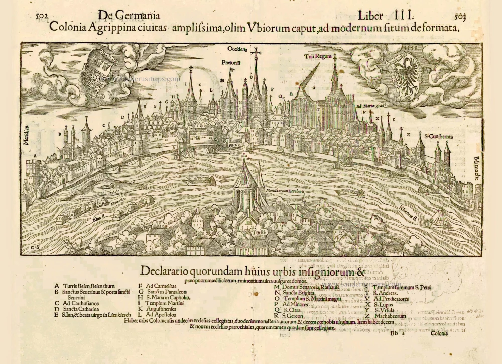
Colonia Agrippina civitas amplissima, olim Ubiorum caput, ad modernum situm deformata. 1552
Cologne (Köln) by Sebastian Münster
[Item number: 27406]

Colonia Agrippina Urbs Ampla ... Inferioris, Sine Secundae Germaniae Caput et Metropolis. 1575
Cologne (Köln), by Georg Braun and Frans Hogenberg.
[Item number: 29417]

Unrecorded variant of Schut's view of Cologne (Köln), by Carel Allard
CÖLLN. 1673
View of Cologne (Köln) by Carel Allard.
[Item number: 30553]

Cölln. 1686
Köln (Cologne) by Christoph Riegel.
[Item number: 31704]

Archiepiscopatus et Electoratus Coloniensis ut et Duvatuum Iuliacensis et Montensis nec non Comitatus Meursiae Nova Tabula. c. 1720
Archbishopric and Electorate of Cologne, including the Duchies of Jülich and Berg, as well as the County of Meurs, by J.B. Homann.
[Item number: 32927]