
Costumes from Dithmarschen, by Georg Braun and Frans Hogenberg. 1596
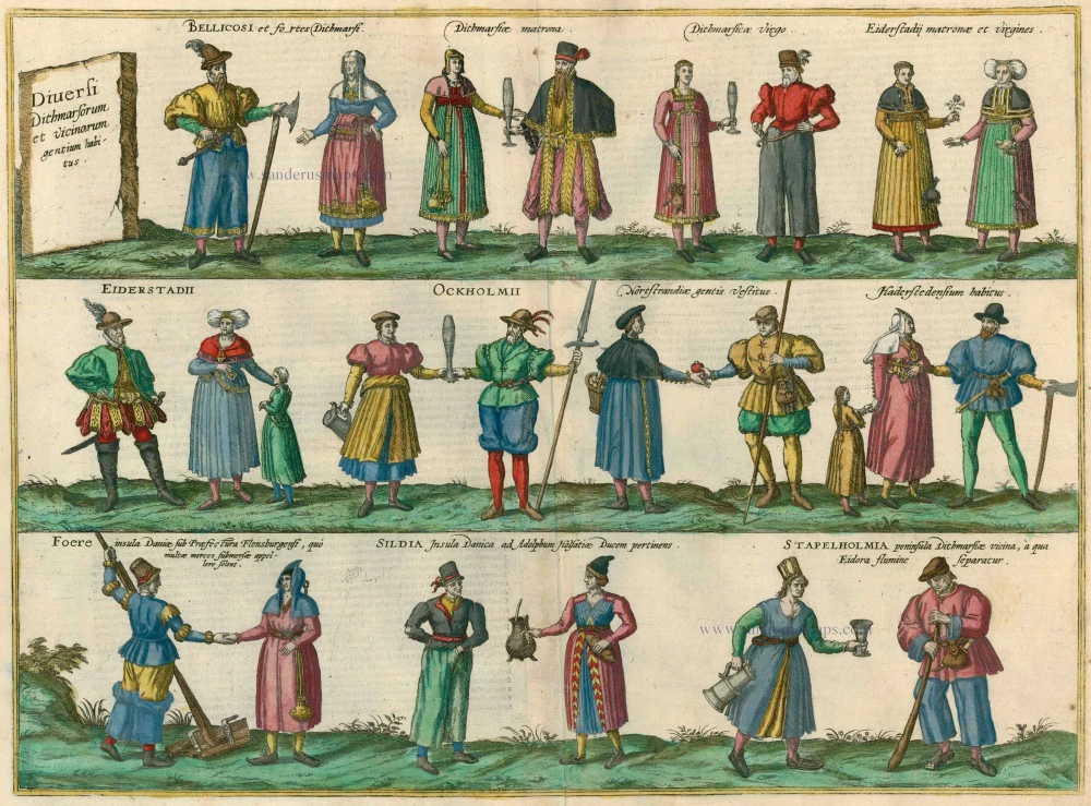


TRANSLATION OF CAPTION: Various costumes from Dithmarschen and the surrounding area.
COMMENTARY BY BRAUN: "Dithmarschen is a region bordering on Holstein; it takes his name from its own dialect. For as it is not forested like Holstein but is wet and boggy, it is called Dithmarschen after its marshes, namely its swamps, bogs and wetlands"
The plate with its three rows of costumed figures, complements the information on the history of Dithmarschen that is given in Braun's text. The peasant's republic of Dithmarschen lay in Schleswig-Holstein between the North Sea, the Elbe and Eider Rivers. In 1447 Dithmarschen's law was drawn up and the region became an independent, prosperous state. Its fertile marshlands were protected from flooding by dikes, and the peasants farming the land developed a pronounced sense of separate identity, bolstered by the fact that numerous attempts to conquer their territory failed. Not until 1559 was Dithmarschen conquered and divided up between the Duke of Schleswig-Holstein-Gottorp, the Duke of Schleswig-Holstein-Hadersleben and the King of Denmark. The costumed figures illustrate, from left to right, armed men, married and unmarried women from Dithmarschen and married and unmarried women from Eiderstedt, followed by dress styles from Eiderstedt, Ockholm, Nordstrand and Haderstedt and finally by costumes from the Islands of Föhr, Sildia and Stapelholm. (Taschen)
Braun G. & Hogenberg F. and the Civitates Orbis Terrarum.
The Civitates Orbis Terrarum, also known as the 'Braun & Hogenberg', is a six-volume town atlas and the most excellent book of town views and plans ever published: 363 engravings, sometimes beautifully coloured. It was one of the best-selling works in the last quarter of the 16th century. Georg Braun, a skilled writer, wrote the text accompanying the plans and views on the verso. Many plates were engraved after the original drawings of a professional artist, Joris Hoefnagel (1542-1600). The first volume was published in Latin in 1572 and the sixth in 1617. Frans Hogenberg, a talented engraver, created the tables for volumes I through IV, and Simon van den Neuwel made those for volumes V and VI. Other contributors were cartographers Daniel Freese and Heinrich Rantzau, who provided valuable geographical information. Works by Jacob van Deventer, Sebastian Münster, and Johannes Stumpf were also used as references. Translations appeared in German and French, making the atlas accessible to a wider audience.
Since its original publication of volume 1 in 1572, the Civitates Orbis Terrarum has left an indelible mark on the history of cartography. The first volume was followed by seven more editions in 1575, 1577, 1582, 1588, 1593, 1599, and 1612. Vol.2, initially released in 1575, saw subsequent editions in 1597 and 1612. The subsequent volumes, each a treasure trove of historical insights, graced the world in 1581, 1588, 1593, 1599, and 1606. The German translation of the first volume, a testament to its widespread appeal, debuted in 1574, followed by the French edition in 1575.
Several printers were involved: Theodor Graminaeus, Heinrich von Aich, Gottfried von Kempen, Johannis Sinniger, Bertram Buchholtz, and Peter von Brachel, all of whom worked in Cologne.
Georg Braun (1541-1622)
Georg Braun, the author of the text accompanying the plans and views in the Civitates Orbis Terrarum, was born in Cologne in 1541. After his studies in Cologne, he entered the Jesuit Order as a novice, indicating his commitment to learning and intellectual pursuits. In 1561, he obtained his bachelor's degree; in 1562, he received his Magister Artium, further demonstrating his academic achievements. Although he left the Jesuit Order, he continued his studies in theology, gaining a licentiate in theology. His theological background likely influenced the content and tone of the text in the Civitates Orbis Terrarum, adding a unique perspective to the work.
Frans Hogenberg (1535-1590)
Frans Hogenberg was a Flemish and German painter, engraver, and mapmaker. He was born in Mechelen as the son of Nicolaas Hogenberg.
By the end of the 1560s, Frans Hogenberg was employed upon Abraham Ortelius's Theatrum Orbis Terrarum, published in 1570; he is named an engraver of numerous maps. In 1568, he was banned from Antwerp by the Duke of Alva and travelled to London, where he stayed a few years before emigrating to Cologne. He immediately embarked on his two most important works, the Civitates, published in 1572 and the Geschichtsblätter, which appeared in several series from 1569 until about 1587.
Thanks to large-scale projects like the Geschichtsblätter and the Civitates, Hogenberg's social circumstances improved with each passing year. He died as a wealthy man in Cologne in 1590.
Diversi Dithmarsorum et vicinarum gentium habitus.
Item Number: 24169 Authenticity Guarantee
Category: Antique maps > Europe > Germany
Regional costumes from Dithmarschen.
Copper engraving
Size: 36.5 x 50cm (14.2 x 19.4 inches)
Verso text: Latin
Condition: Old coloured, excellent.
Condition Rating: A
References: Van der Krogt 4, 5044; Taschen, Braun and Hogenberg, p.421.
From: Urbium Praeipuarum Mundi Theatrum Quintum Auctore Georgio Braunio Agrippinate. Part 5. Köln, 1598. (Van der Krogt 4, 41:1.5)
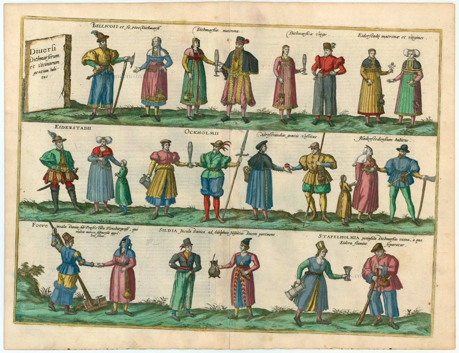
TRANSLATION OF CAPTION: Various costumes from Dithmarschen and the surrounding area.
COMMENTARY BY BRAUN: "Dithmarschen is a region bordering on Holstein; it takes his name from its own dialect. For as it is not forested like Holstein but is wet and boggy, it is called Dithmarschen after its marshes, namely its swamps, bogs and wetlands"
The plate with its three rows of costumed figures, complements the information on the history of Dithmarschen that is given in Braun's text. The peasant's republic of Dithmarschen lay in Schleswig-Holstein between the North Sea, the Elbe and Eider Rivers. In 1447 Dithmarschen's law was drawn up and the region became an independent, prosperous state. Its fertile marshlands were protected from flooding by dikes, and the peasants farming the land developed a pronounced sense of separate identity, bolstered by the fact that numerous attempts to conquer their territory failed. Not until 1559 was Dithmarschen conquered and divided up between the Duke of Schleswig-Holstein-Gottorp, the Duke of Schleswig-Holstein-Hadersleben and the King of Denmark. The costumed figures illustrate, from left to right, armed men, married and unmarried women from Dithmarschen and married and unmarried women from Eiderstedt, followed by dress styles from Eiderstedt, Ockholm, Nordstrand and Haderstedt and finally by costumes from the Islands of Föhr, Sildia and Stapelholm. (Taschen)
Braun G. & Hogenberg F. and the Civitates Orbis Terrarum.
The Civitates Orbis Terrarum, also known as the 'Braun & Hogenberg', is a six-volume town atlas and the most excellent book of town views and plans ever published: 363 engravings, sometimes beautifully coloured. It was one of the best-selling works in the last quarter of the 16th century. Georg Braun, a skilled writer, wrote the text accompanying the plans and views on the verso. Many plates were engraved after the original drawings of a professional artist, Joris Hoefnagel (1542-1600). The first volume was published in Latin in 1572 and the sixth in 1617. Frans Hogenberg, a talented engraver, created the tables for volumes I through IV, and Simon van den Neuwel made those for volumes V and VI. Other contributors were cartographers Daniel Freese and Heinrich Rantzau, who provided valuable geographical information. Works by Jacob van Deventer, Sebastian Münster, and Johannes Stumpf were also used as references. Translations appeared in German and French, making the atlas accessible to a wider audience.
Since its original publication of volume 1 in 1572, the Civitates Orbis Terrarum has left an indelible mark on the history of cartography. The first volume was followed by seven more editions in 1575, 1577, 1582, 1588, 1593, 1599, and 1612. Vol.2, initially released in 1575, saw subsequent editions in 1597 and 1612. The subsequent volumes, each a treasure trove of historical insights, graced the world in 1581, 1588, 1593, 1599, and 1606. The German translation of the first volume, a testament to its widespread appeal, debuted in 1574, followed by the French edition in 1575.
Several printers were involved: Theodor Graminaeus, Heinrich von Aich, Gottfried von Kempen, Johannis Sinniger, Bertram Buchholtz, and Peter von Brachel, all of whom worked in Cologne.
Georg Braun (1541-1622)
Georg Braun, the author of the text accompanying the plans and views in the Civitates Orbis Terrarum, was born in Cologne in 1541. After his studies in Cologne, he entered the Jesuit Order as a novice, indicating his commitment to learning and intellectual pursuits. In 1561, he obtained his bachelor's degree; in 1562, he received his Magister Artium, further demonstrating his academic achievements. Although he left the Jesuit Order, he continued his studies in theology, gaining a licentiate in theology. His theological background likely influenced the content and tone of the text in the Civitates Orbis Terrarum, adding a unique perspective to the work.
Frans Hogenberg (1535-1590)
Frans Hogenberg was a Flemish and German painter, engraver, and mapmaker. He was born in Mechelen as the son of Nicolaas Hogenberg.
By the end of the 1560s, Frans Hogenberg was employed upon Abraham Ortelius's Theatrum Orbis Terrarum, published in 1570; he is named an engraver of numerous maps. In 1568, he was banned from Antwerp by the Duke of Alva and travelled to London, where he stayed a few years before emigrating to Cologne. He immediately embarked on his two most important works, the Civitates, published in 1572 and the Geschichtsblätter, which appeared in several series from 1569 until about 1587.
Thanks to large-scale projects like the Geschichtsblätter and the Civitates, Hogenberg's social circumstances improved with each passing year. He died as a wealthy man in Cologne in 1590.
Related items
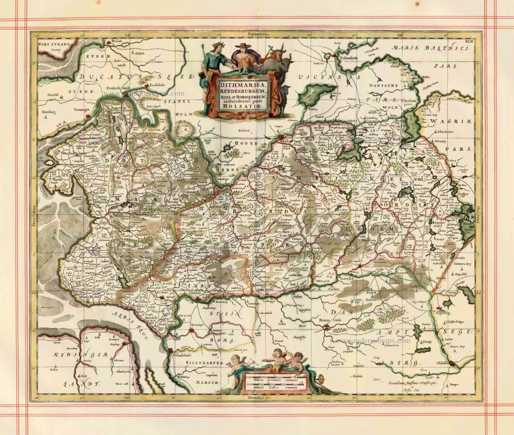
Dithmarsia, Rendesburgum, Kiel et Bordesholm in Occidentali parte Holsatiae 1680
Dithmarschen, Rendsburg, Kiel by J. Janssonius, published by Moses Pitt and J. Janssonius-Waesberge.
[Item number: 1705]
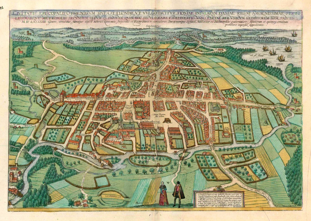
Civitates Episcopalis Othenarum sive Otthoniae, ut vulgo Dicitur, Fioniae ... c. 1610
Odense, by Georg Braun and Frans Hogenberg.
[Item number: 16703]
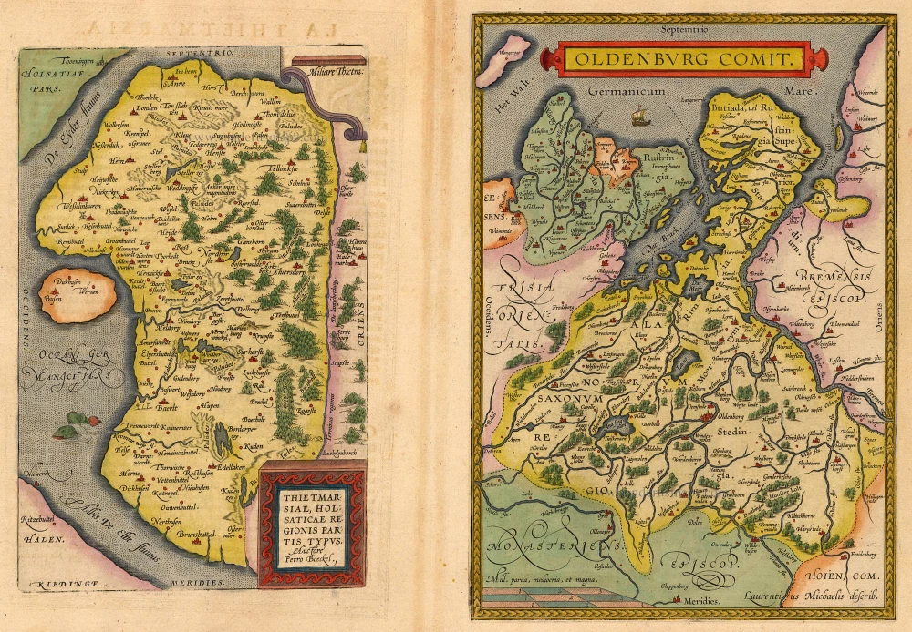
Thietmarsiae, Holsaticae Regionis Partis Typus. - Oldenburg Comit. 1612
Dithmarschen - Oldenburg, by Abraham Ortelius.
[Item number: 18704]
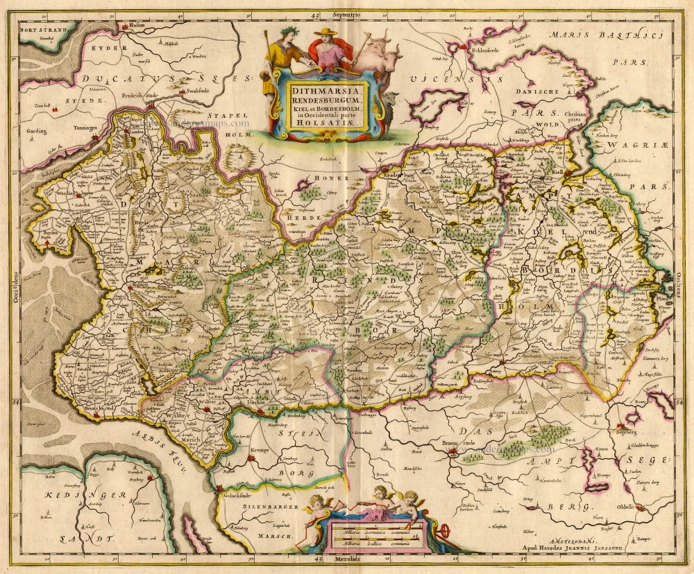
Dithmarsia, Rendesburgum, Kiel et Bordesholm in Occidentali parte Holsatiae c. 1680.
Dithmarschen, Rendsburg, Kiel, by Hondius H. - Janssonius J
[Item number: 18720]
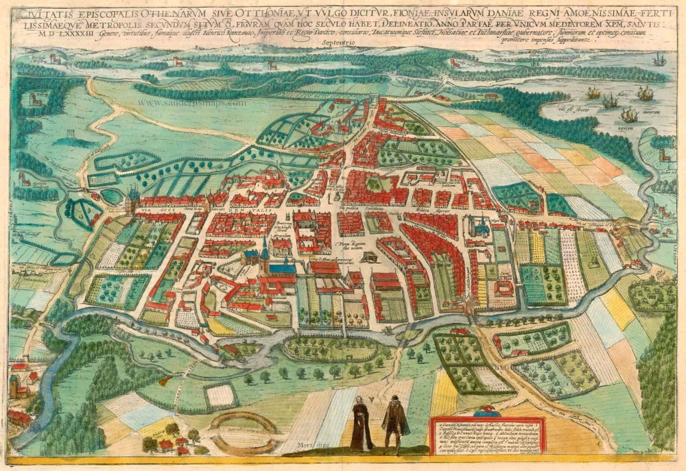
Civitates Episcopalis Othenarum sive Otthoniae, ut vulgo Dicitur, Fioniae ... 1596-1640
Odense, by Georg Braun and Frans Hogenberg.
[Item number: 23372]
Diversi Dithmarsorum et vicinarum gentium habitus. 1596
Costumes from Dithmarschen, by Georg Braun and Frans Hogenberg.
[Item number: 24169]
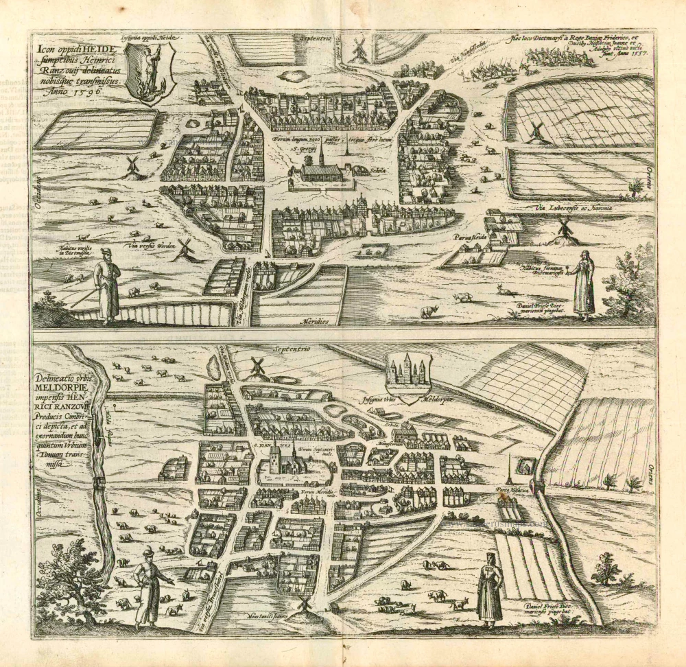
Icon Oppidi Heide [on sheet with] Delineatio Urbis Meldorpie 1596
Two bird's-eye plans by Braun and Hogenberg: Heide and Meldorf.
[Item number: 24170]