
Old, antique map of Bamberg by Braun & Hogenberg 1617


Braun G. & Hogenberg F. and the Civitates Orbis Terrarum.
The Civitates Orbis Terrarum, also known as the 'Braun & Hogenberg', is a six-volume town atlas and the most excellent book of town views and plans ever published: 363 engravings, sometimes beautifully coloured. It was one of the best-selling works in the last quarter of the 16th century. Georg Braun, a skilled writer, wrote the text accompanying the plans and views on the verso. Many plates were engraved after the original drawings of a professional artist, Joris Hoefnagel (1542-1600). The first volume was published in Latin in 1572 and the sixth in 1617. Frans Hogenberg, a talented engraver, created the tables for volumes I through IV, and Simon van den Neuwel made those for volumes V and VI. Other contributors were cartographers Daniel Freese and Heinrich Rantzau, who provided valuable geographical information. Works by Jacob van Deventer, Sebastian Münster, and Johannes Stumpf were also used as references. Translations appeared in German and French, making the atlas accessible to a broader audience.
Since its original publication of volume 1 in 1572, the Civitates Orbis Terrarum has left an indelible mark on the history of cartography. Seven more editions followed the first volume in 1575, 1577, 1582, 1588, 1593, 1599, and 1612. Vol.2, initially released in 1575, saw subsequent editions in 1597 and 1612. The subsequent volumes, each a treasure trove of historical insights, graced the world in 1581, 1588, 1593, 1599, and 1606. The German translation of the first volume, a testament to its widespread appeal, debuted in 1574, followed by the French edition in 1575.
Several printers were involved: Theodor Graminaeus, Heinrich von Aich, Gottfried von Kempen, Johannis Sinniger, Bertram Buchholtz, and Peter von Brachel, all of whom worked in Cologne.
Georg Braun (1541-1622)
Georg Braun, the author of the text accompanying the plans and views in the Civitates Orbis Terrarum, was born in Cologne in 1541. After his studies in Cologne, he entered the Jesuit Order as a novice, indicating his commitment to learning and intellectual pursuits. In 1561, he obtained his bachelor's degree; in 1562, he received his Magister Artium, further demonstrating his academic achievements. Although he left the Jesuit Order, he continued his studies in theology, gaining a licentiate in theology. His theological background likely influenced the content and tone of the text in the Civitates Orbis Terrarum, adding a unique perspective to the work.
Frans Hogenberg (1535-1590)
Frans Hogenberg was a Flemish and German painter, engraver, and mapmaker. He was born in Mechelen as the son of Nicolaas Hogenberg.
By the end of the 1560s, Frans Hogenberg was employed upon Abraham Ortelius's Theatrum Orbis Terrarum, published in 1570; he is named an engraver of numerous maps. In 1568, he was banned from Antwerp by the Duke of Alva and travelled to London, where he stayed a few years before emigrating to Cologne. He immediately embarked on his two most important works, the Civitates, published in 1572 and the Geschichtsblätter, which appeared in several series from 1569 until about 1587.
Thanks to large-scale projects like the Geschichtsblätter and the Civitates, Hogenberg's social circumstances improved with each passing year. He died as a wealthy man in Cologne in 1590.
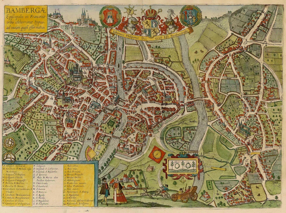
Bambergae Episcopalis in Franconiae typus, ad vivum quasi efformatus.
Item Number: 22135 Authenticity Guarantee
Category: Antique maps > Europe > Germany
Antique map - Bird's-eye view of Bambergen b y Braun and Hogenberg, with key to locations.
TRANSLATION OF CARTOUCHE TEXT: Impression of the well-known episcopal city of Bamberg, drawn true to life.
COMMENTARY BY BRAUN (on verso): "The Emperor Henry the Holy and his wife Cunigunde set up a bishopric and built a splendid collegiate church in this city, and invited Pope Benedict VIII to come personally to consecrate the church. Then 72 bishops met in this town together with the Emperor, the princes and the imperial estates, to welcome the Pope with great honours and to be present at the consecration of both the Benedictine monastery and the collegiate church."
This bird's-eye view from the south has the character of a street plan, and clearly shows the two centres of the city: the Gothic cathedral dedicated to St Peter (A) is the seat of spiritual power. It was erected on the site of the building endowed by the Ottonian Emperor Henry II in the 11th century, which was destroyed by fire. The centre of the Old Town is marked by the town hall, built on a man-made island in the Regnitz. Directly below the palace can be seen on the northern tip of a second island, which was the residence of the prince-bishop from 1580 onwards. Top left is the Benedictine monastery of St Michael, above a vineyard. The ornatley framed liquorice plants symbolize the importance of vegetable cultivation in the garden city on the far side of the right-hand arm of the Regnitz. (Taschen)
Date of the first edition: 1617
Date of this map: 1617
Copper engraving
Size: 37 x 51cm (14.4 x 19.9 inches)
Verso text: Latin
Condition: Old coloured, excellent.
Condition Rating: A
References: Van der Krogt 4, 356, State 1; Taschen, Braun and Hogenberg, p.439.
From: Theatri praecipuarum Totius Mundi Urbium Liber Sextus Anno MDCXVII. (Koeman, B&H6)
Braun G. & Hogenberg F. and the Civitates Orbis Terrarum.
The Civitates Orbis Terrarum, also known as the 'Braun & Hogenberg', is a six-volume town atlas and the most excellent book of town views and plans ever published: 363 engravings, sometimes beautifully coloured. It was one of the best-selling works in the last quarter of the 16th century. Georg Braun, a skilled writer, wrote the text accompanying the plans and views on the verso. Many plates were engraved after the original drawings of a professional artist, Joris Hoefnagel (1542-1600). The first volume was published in Latin in 1572 and the sixth in 1617. Frans Hogenberg, a talented engraver, created the tables for volumes I through IV, and Simon van den Neuwel made those for volumes V and VI. Other contributors were cartographers Daniel Freese and Heinrich Rantzau, who provided valuable geographical information. Works by Jacob van Deventer, Sebastian Münster, and Johannes Stumpf were also used as references. Translations appeared in German and French, making the atlas accessible to a broader audience.
Since its original publication of volume 1 in 1572, the Civitates Orbis Terrarum has left an indelible mark on the history of cartography. Seven more editions followed the first volume in 1575, 1577, 1582, 1588, 1593, 1599, and 1612. Vol.2, initially released in 1575, saw subsequent editions in 1597 and 1612. The subsequent volumes, each a treasure trove of historical insights, graced the world in 1581, 1588, 1593, 1599, and 1606. The German translation of the first volume, a testament to its widespread appeal, debuted in 1574, followed by the French edition in 1575.
Several printers were involved: Theodor Graminaeus, Heinrich von Aich, Gottfried von Kempen, Johannis Sinniger, Bertram Buchholtz, and Peter von Brachel, all of whom worked in Cologne.
Georg Braun (1541-1622)
Georg Braun, the author of the text accompanying the plans and views in the Civitates Orbis Terrarum, was born in Cologne in 1541. After his studies in Cologne, he entered the Jesuit Order as a novice, indicating his commitment to learning and intellectual pursuits. In 1561, he obtained his bachelor's degree; in 1562, he received his Magister Artium, further demonstrating his academic achievements. Although he left the Jesuit Order, he continued his studies in theology, gaining a licentiate in theology. His theological background likely influenced the content and tone of the text in the Civitates Orbis Terrarum, adding a unique perspective to the work.
Frans Hogenberg (1535-1590)
Frans Hogenberg was a Flemish and German painter, engraver, and mapmaker. He was born in Mechelen as the son of Nicolaas Hogenberg.
By the end of the 1560s, Frans Hogenberg was employed upon Abraham Ortelius's Theatrum Orbis Terrarum, published in 1570; he is named an engraver of numerous maps. In 1568, he was banned from Antwerp by the Duke of Alva and travelled to London, where he stayed a few years before emigrating to Cologne. He immediately embarked on his two most important works, the Civitates, published in 1572 and the Geschichtsblätter, which appeared in several series from 1569 until about 1587.
Thanks to large-scale projects like the Geschichtsblätter and the Civitates, Hogenberg's social circumstances improved with each passing year. He died as a wealthy man in Cologne in 1590.
Related items
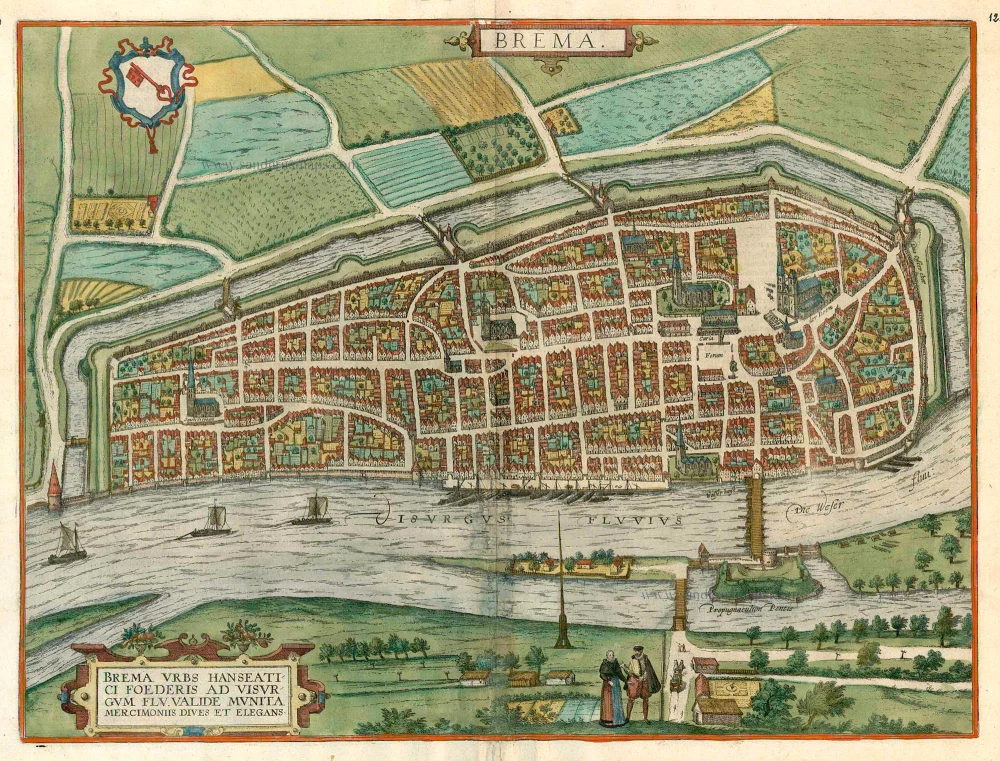
Brema. c. 1610
Bremen, by Georg Braun and Frans Hogenberg.
[Item number: 16673]

Brunopolis vulgo Brunsvicum, ... [on sheet with] Luneburgum, Nobilis Saxoniae Urbs, ... [and] Brema [and] Aldenburgum Holsatiae. 1572
Braunschweig, Luneburg, Bremen, and Stade, by Georg Braun and Frans Hogenberg.
[Item number: 21609]

Dresden - Dresa Florentissimum Misniae Opp. Illust: Saxoniae Ducum Sedes [on sheet with] Leibzigk - Lipsia Litterarum Studiis et Mercatura Celebre Misniae Oppidum 1612
Dresden and Leipzig, by Georg Braun and Frans Hogenberg.
[Item number: 22326]

Augusta Iuxta Figuram ... 1612
Augsburg, by Georg Braun and Frans Hogenberg.
[Item number: 22337]

Chorographica Descriptio Civitatis Cocheimensis [on sheet with] Exactissima Civitatis Monasteriensis in Campo Meyfeldensi Chorographica Des. 1600
Cochem and Münstermaifeld, by Georg Braun and Frans Hogenberg.
[Item number: 23367]

Arnsberg. 1599
Arnsberg by Braun and Hogenberg.
[Item number: 24096]