
The Oberpfalz, by Willem Blaeu. 1659-72

The Blaeus: Willem Janszoon, Cornelis & Joan
Willem Jansz. Blaeu and his son Joan Blaeu are the most widely known cartographic publishers of the seventeenth century.
Willem Jansz. (also written Guilielmus Janssonius) = Willem Janszoon Blaeu, was born in Uitgeest (Netherlands), near Alkmaar in 1571. He studied mathematics under Tycho Brahe and learned the theory and practice of astronomical observations and the art of instrument- and globe making.
In 1596 he came to Amsterdam where he settled down as a globe-, instrument- and map-maker. He published his first cartographic work (a globe) in 1599 and probably published his first printed map (a map of the Netherlands) in 1604. He specialized in maritime cartography and published the first edition of the pilot guide Het Licht der Zeevaert in 1608, and was appointed Hydrographer of the V.O.C. (United East India Company) in 1633. After thirty years of publishing books, wall maps, globes, charts and pilot guides, he brought out his first atlas, Atlas Appendix (1630). This was the beginning of the great tradition of atlas-making by the Blaeus.
In 1618 another mapmaker, bookseller and publisher, Johannes Janssonius established himself in Amsterdam next door to Blaeu's shop. It is no wonder that these two neighbours, who began accusing each other of copying and stealing their information, became fierce competitors who did not have a good word to say about each other. In about 1621 Willem Jansz. decided to put an end to the confusion between his name and his competitor's, and assumed his grandfather's sobriquet, 'blauwe Willem' ('blue Willem'), as the family name; thereafter he called himself Willem Jansz. Blaeu.
Willem Janszoon Blaeu died in 1638, leaving his prospering business to his sons, Cornelis and Joan. Of Cornelis we only know that his name occurs in the prefaces of books and atlases until c. 1645.
Joan Blaeu, born in Amsterdam, 1596, became partner in his father’s book trade and printing business. In 1638 he was appointed his father’s successor in the Hydrographic office of the V.O.C. His efforts culminated in the magnificent Atlas Major and the town-books of the Netherland and of Italy – works unsurpassed in history and in modern times, which gave eternal fame to the name of the Blaeus.
On February 23, 1672, a fire ruined the business. One year later, Dr. Joan Blaeu died. The fire of 1672 and the passing away of the director gave rise to a complete sale of the stock of the Blaeu House. Five public auctions dispersed the remaining books, atlases, copperplates, globes, etc., among many other map dealers and publishers in Amsterdam. The majority was acquired by a number of booksellers acting in partnership.
In the succeeding years, the remaining printing department was left in the hands of the Blaeu family until 1695 when also the inventory of the printing house was sold at a public auction. That meant the end of the Blaeus as a printing house of world renown.
Palatinatus Bavariae.
Item Number: 9806 Authenticity Guarantee
Category: Antique maps > Europe > Germany
Old, antique map of the Oberpfalz, by Willem Blaeu.
Title: Palatinatus Bavariae.
Amsterdami Excudit Guiljelmus Blaeuw.
Date of the first edition: 1634.
Date of this map: 1659-72.
Copper engraving, printed on paper.
Size (not including margins): 385 x 505mm (15.16 x 19.88 inches).
Verso: Spanish text.
Condition: Original coloured, excellent.
Condition Rating: A+.
From: Nuevo Atlas o Teatro del Mundo, ... En Amsterdam, A costa en casa de Juan Blaeu, 1659-72. (Van der Krogt 2, 641)
The Blaeus: Willem Janszoon, Cornelis & Joan
Willem Jansz. Blaeu and his son Joan Blaeu are the most widely known cartographic publishers of the seventeenth century.
Willem Jansz. (also written Guilielmus Janssonius) = Willem Janszoon Blaeu, was born in Uitgeest (Netherlands), near Alkmaar in 1571. He studied mathematics under Tycho Brahe and learned the theory and practice of astronomical observations and the art of instrument- and globe making.
In 1596 he came to Amsterdam where he settled down as a globe-, instrument- and map-maker. He published his first cartographic work (a globe) in 1599 and probably published his first printed map (a map of the Netherlands) in 1604. He specialized in maritime cartography and published the first edition of the pilot guide Het Licht der Zeevaert in 1608, and was appointed Hydrographer of the V.O.C. (United East India Company) in 1633. After thirty years of publishing books, wall maps, globes, charts and pilot guides, he brought out his first atlas, Atlas Appendix (1630). This was the beginning of the great tradition of atlas-making by the Blaeus.
In 1618 another mapmaker, bookseller and publisher, Johannes Janssonius established himself in Amsterdam next door to Blaeu's shop. It is no wonder that these two neighbours, who began accusing each other of copying and stealing their information, became fierce competitors who did not have a good word to say about each other. In about 1621 Willem Jansz. decided to put an end to the confusion between his name and his competitor's, and assumed his grandfather's sobriquet, 'blauwe Willem' ('blue Willem'), as the family name; thereafter he called himself Willem Jansz. Blaeu.
Willem Janszoon Blaeu died in 1638, leaving his prospering business to his sons, Cornelis and Joan. Of Cornelis we only know that his name occurs in the prefaces of books and atlases until c. 1645.
Joan Blaeu, born in Amsterdam, 1596, became partner in his father’s book trade and printing business. In 1638 he was appointed his father’s successor in the Hydrographic office of the V.O.C. His efforts culminated in the magnificent Atlas Major and the town-books of the Netherland and of Italy – works unsurpassed in history and in modern times, which gave eternal fame to the name of the Blaeus.
On February 23, 1672, a fire ruined the business. One year later, Dr. Joan Blaeu died. The fire of 1672 and the passing away of the director gave rise to a complete sale of the stock of the Blaeu House. Five public auctions dispersed the remaining books, atlases, copperplates, globes, etc., among many other map dealers and publishers in Amsterdam. The majority was acquired by a number of booksellers acting in partnership.
In the succeeding years, the remaining printing department was left in the hands of the Blaeu family until 1695 when also the inventory of the printing house was sold at a public auction. That meant the end of the Blaeus as a printing house of world renown.
Related items

Circulus Bavaricus in quo sunt ... c. 1715
Bayern by de Wit - Covens & Mortier.
[Item number: 1266]

Paderbornensis Episcopatus 1649-55
Paderborn, by Willem Blaeu.
[Item number: 2429]

Scarce
Bavariae Utriusque cum Inferioris tu Superioris Vera et ad Amus Sim Descriptio 1593
Bayern, by de Jode.
[Item number: 5101]

Waldeck Comitatus 1659-72
Waldeck by Willem Blaeu.
[Item number: 9549]

Wetteravia Vulgo Die Wetteraw. 1659-72
Wetterau, by Willem Blaeu
[Item number: 9550]

Civitatis Imp. Lindaviensis Territorium. 1659-72
Lindau, by Blaeu Willem.
[Item number: 9566]

Westphalia Ducatus. 1662
Westfalen, by Blaeu W. & J.
[Item number: 9687]

Misnia Marchionatus. - Meissen. 1662
Meissen, by J. Blaeu.
[Item number: 9868]
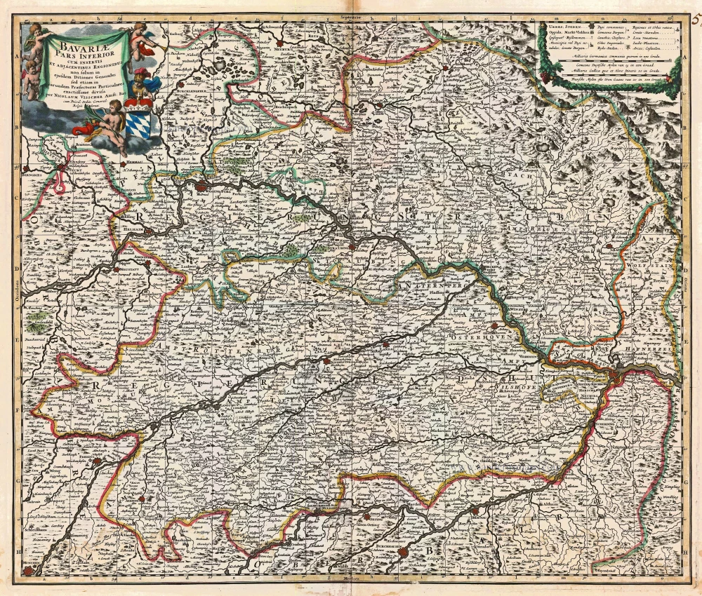
Bavariae Pars Inferior cum insertis et adjacentibus Regionibus ... 1683-1696
Bavaria (Bayern), by N. Visscher.
[Item number: 14590]
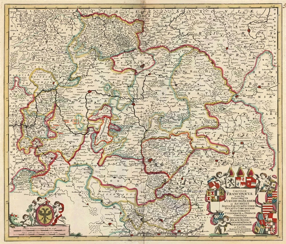
Circulus Franconicus in quo sunt Episcopatus Wurtzburg, Bamberg et Aichstet, Status Equitum Teutonicor Ducatus Coburgensis, Marchionatus Cullembach, et Onspach, Comitatus Henneberg, Wertheim Holach, Reinec, Papenheim, Erpach Schwartzenberg, et Castel, Baronatus Sensheim et Territorium Norinbergensis. c. 1682-96
Bavaria (Bayern) by F. de Wit
[Item number: 14815]

Alemannia sive Suevia Superior. 1647-50
Oberschwaben, by Blaeu W.
[Item number: 18630]
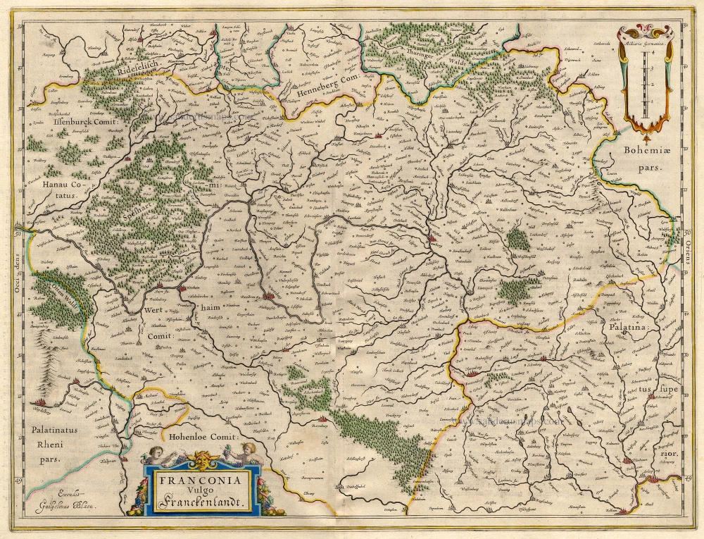
Franconia Vulgo Franckenlandt. 1642-43
Franconia, by Blaeu W.
[Item number: 18731]

Wirtenberg Ducatus. 1647-50
Württemberg, by Blaeu W.
[Item number: 18906]

Episcopatus Hildesiensis Descriptio Novissima. 1647-50
Hildesheim, by Blaeu W.
[Item number: 18910]

Bavariae olim Vindeliciae, delineationis compendium 1612
Bayern, by A. Ortelius.
[Item number: 23005]

Le Cercle de Baviere subdivisé en tous les Estats qui le composent ... 1721-41
Bavaria (Bayern), by Covens & Mortier.
[Item number: 23814]
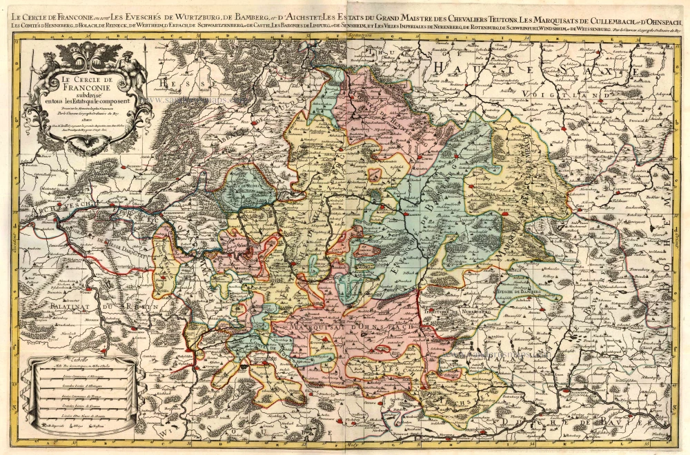
Le Cercle de Franconie subdivisé en tous les Estats qui le composent. c. 1695
Bavaria (Bayern) by Hubert Jaillot - Covens & Mortier.
[Item number: 23819]

Partie Orientale du Cercle de Franconie. 1721-41
Bavaria (Bayern), by Covens & Mortier.
[Item number: 23820]

Circulus Bavaricus in quo sunt Ducatus Electoratus, & Palatinat Bavariae, Archiepisc. Salisburgi, Episcopatus Ratisbonae, Pataviae, & Fruxini, Palatinat Neoburgi & Landgravius Leuchtenbergi. c. 1680
Bayern, by F. De Wit.
[Item number: 24403]

Bavaria Ducatus 1623
Bayern, by G. Mercator.
[Item number: 24950]

La description de Souabe et Baviere. 1555
Bayern, by S. Munster.
[Item number: 25169]

Palatinatus Bavariae. 1653
Oberpfalz by Johannes Janssonius.
[Item number: 30391]