
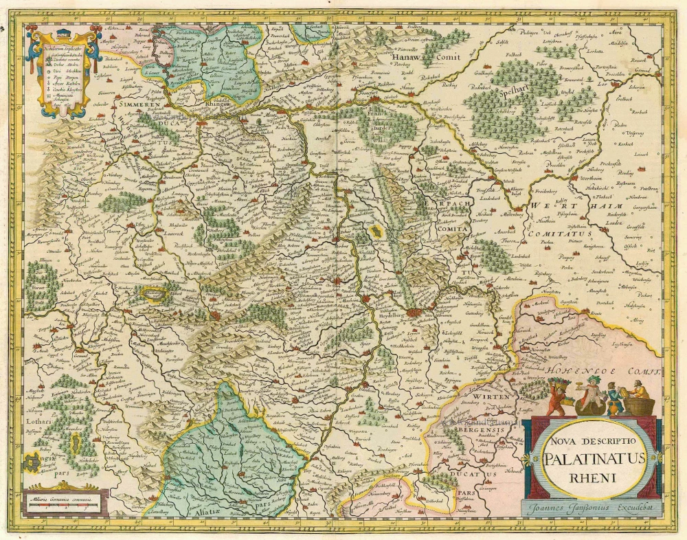
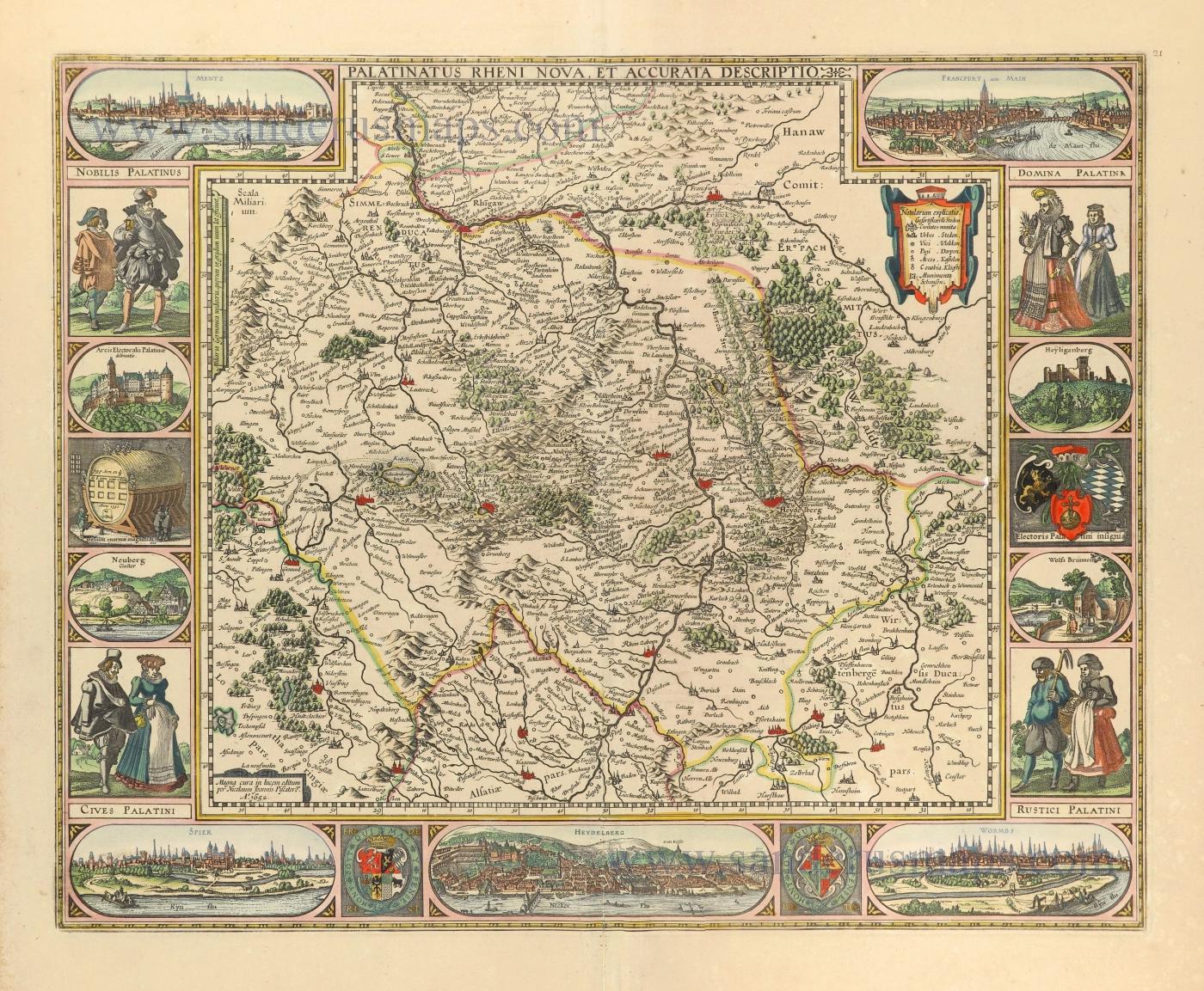
Rheinland-Pfalz, by Claes Jansz. Visscher. 1630


Visscher's map of the Palatinate of the Rhine is one of the many cartographical products created during the Bohemian-Palatine War (1620/21).
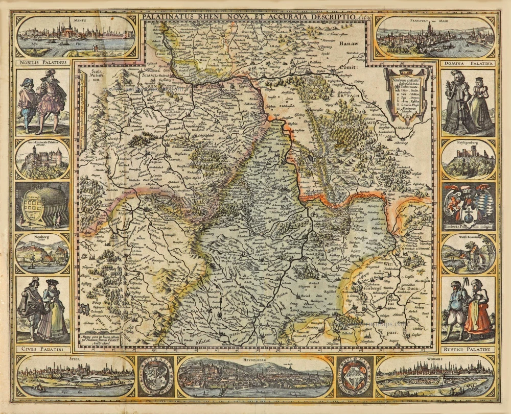
The title runs along the centre of the upper edge of the map, surrounded by the views of Mainz and Frankfurt in the top corners, which extend into the map area.
The map is framed at the sides and bottom by costumed figures, town views, coats of arms and the cask of Heidelberg.
The town views are based on depictions in the Civitates Orbis Terrarum, 1572, by Braun and Hogenberg.
The Visscher Family
For nearly a century, the members of the Visscher family were essential art dealers and map publishers in Amsterdam.
Claes Jansz. Visscher, or N.J. Piscator (1587-1652)
Claes Jansz. Vischer bought a house in Amsterdam, 'de gulden Bors', on the crucial Kalverstraat and changed the name into "In de Visscher"; under this title, the shop was to flourish for many years.
He was famous for his engravings and etchings of Dutch landscapes and 'historical scenes', such as sieges, battles, etc. These 'historical scenes' were considered contemporary illustrated news items, especially e.g. that of 'the Eighty Years' War'.
For the publication of his first atlas, he bought copperplates of the atlas Germania Inferior by Pieter van den Keere (1623).
In 1649, he published an atlas entitled Tabularum Geographicarum Contractarum, containing the same maps as Langenes' Caert Thresoor, for which Visscher had only new title pages engraved.
Claes Jansz. Visscher died in 1652. His wife, Neeltjen Florisdr., had already died in 1640. They had seven children, four of whom were still alive at Claes Jansz.'s death. One was Nicolaes Visscher I, who was to continue his father's business.
Nicolaes Visscher I (1618-1679)
Nicolaes Visscher I partnered with his father, continued the business, and stayed on the Kalverstraat 'in de Visscher' till his death.
In about 1657, the first edition of his Atlas Contractus Orbis Terrarum appeared.
Between 1664 and 1677, several editions of his Atlas Contractus appeared without a printed index, for these atlases had no fixed contents but were composed according to the buyer's financial leaping pole.
In May 1664, Nicolaes Visscher was admitted as a member of the Booksellers' Guild of his town. In July 1677, he was granted a patent of the States of Holland and West-Friesland for printing and publishing maps and atlases for 15 years.
After this, he again published an Atlas Contractus with a printed index. At about the same time, he also brought out an Atlas Minor.
Nicolaes Visscher II (1649-1702)
Nicolaes Visscher II inherited the 'shop' from his father. To obtain a new privilege, he applied to the States of Holland and West-Friesland in 1682 for a patent for printing and publishing maps. This patent was granted to him the same year. He moved the firm to the Dam, but it kept the same signboard: "In de Visscher".
Around 1683, he published his first Atlas Minor with a printed index of 91 maps. In 1684, an atlas Germania Inferior appeared. Till 1697, he published another number of atlases. He used his grandfather's (Claes Jansz.) maps less often now and relied more and more on his own.
The wars waged at this time initiated the compilation of maps of the countries where the armies operated. Many war maps were included in the various editions of his Atlas Minor.
After Nicolaes's death, his wife, Elizabeth Verseyl, published all the war maps as an atlas under the title De Stoel des Oorlogs in de Wereld (The seat of war in the world).
The widow of Nicolaes Visscher II (?-1726)
His widow continued the business energetically, and by her hand, under the name of her deceased husband, numerous atlases appeared, e.g., several editions of the Atlas Minor, an Atlas Maior and De Stoel des Oorlogs. The shop enjoyed a high reputation due to the assortment's incredible variety. Not only 'Visscher' maps but also maps of other publishers were obtainable. With the death of Elizabeth Verseyl in 1726, the last descendant died of a great map- and atlas-publishing firm in Amsterdam.
Palatinatus Rheni Nova et Accurata Descriptio. A° 1630.
Item Number: 28024 Authenticity Guarantee
Category: Antique maps > Europe > Germany
Rheinland-Pfalz, by Claes Jansz. Visscher.
Title: Palatinatus Rheni Nova et Accurata Descriptio. A° 1630.
Magna cura in lucem editum per Nicolaum Joannis Piscatore. Amsterodami.
Date of the first edition: 1621.
Date of this map: 1630.
Date on map: 1630.
Copper engraving, printed on paper.
Image size: 450 x 555mm (17¾ x 21¾ inches).
Sheet size: 470 x 580mm (18½ x 22¾ inches).
Verso: Blank.
Condition: Original coloured, two additional vertical folds, reinstatement of an area at the left vertical fold (38 x 3 cm).
Condition Rating: C.
From: Belgium sive Germania Inferior continens provincias singulares septemdecim iuxta artem Geographicam perfectissime descripta, variisque regionum partibus distinctis tabulis aucta per N.J. Piscatorem. Anno 1634. (Koeman, III, Vis1 A)
Visscher's map of the Palatinate of the Rhine is one of the many cartographical products created during the Bohemian-Palatine War (1620/21).
The title runs along the centre of the upper edge of the map, surrounded by the views of Mainz and Frankfurt in the top corners, which extend into the map area.
The map is framed at the sides and bottom by costumed figures, town views, coats of arms and the cask of Heidelberg.
The town views are based on depictions in the Civitates Orbis Terrarum, 1572, by Braun and Hogenberg.
The Visscher Family
For nearly a century, the members of the Visscher family were essential art dealers and map publishers in Amsterdam.
Claes Jansz. Visscher, or N.J. Piscator (1587-1652)
Claes Jansz. Vischer bought a house in Amsterdam, 'de gulden Bors', on the crucial Kalverstraat and changed the name into "In de Visscher"; under this title, the shop was to flourish for many years.
He was famous for his engravings and etchings of Dutch landscapes and 'historical scenes', such as sieges, battles, etc. These 'historical scenes' were considered contemporary illustrated news items, especially e.g. that of 'the Eighty Years' War'.
For the publication of his first atlas, he bought copperplates of the atlas Germania Inferior by Pieter van den Keere (1623).
In 1649, he published an atlas entitled Tabularum Geographicarum Contractarum, containing the same maps as Langenes' Caert Thresoor, for which Visscher had only new title pages engraved.
Claes Jansz. Visscher died in 1652. His wife, Neeltjen Florisdr., had already died in 1640. They had seven children, four of whom were still alive at Claes Jansz.'s death. One was Nicolaes Visscher I, who was to continue his father's business.
Nicolaes Visscher I (1618-1679)
Nicolaes Visscher I partnered with his father, continued the business, and stayed on the Kalverstraat 'in de Visscher' till his death.
In about 1657, the first edition of his Atlas Contractus Orbis Terrarum appeared.
Between 1664 and 1677, several editions of his Atlas Contractus appeared without a printed index, for these atlases had no fixed contents but were composed according to the buyer's financial leaping pole.
In May 1664, Nicolaes Visscher was admitted as a member of the Booksellers' Guild of his town. In July 1677, he was granted a patent of the States of Holland and West-Friesland for printing and publishing maps and atlases for 15 years.
After this, he again published an Atlas Contractus with a printed index. At about the same time, he also brought out an Atlas Minor.
Nicolaes Visscher II (1649-1702)
Nicolaes Visscher II inherited the 'shop' from his father. To obtain a new privilege, he applied to the States of Holland and West-Friesland in 1682 for a patent for printing and publishing maps. This patent was granted to him the same year. He moved the firm to the Dam, but it kept the same signboard: "In de Visscher".
Around 1683, he published his first Atlas Minor with a printed index of 91 maps. In 1684, an atlas Germania Inferior appeared. Till 1697, he published another number of atlases. He used his grandfather's (Claes Jansz.) maps less often now and relied more and more on his own.
The wars waged at this time initiated the compilation of maps of the countries where the armies operated. Many war maps were included in the various editions of his Atlas Minor.
After Nicolaes's death, his wife, Elizabeth Verseyl, published all the war maps as an atlas under the title De Stoel des Oorlogs in de Wereld (The seat of war in the world).
The widow of Nicolaes Visscher II (?-1726)
His widow continued the business energetically, and by her hand, under the name of her deceased husband, numerous atlases appeared, e.g., several editions of the Atlas Minor, an Atlas Maior and De Stoel des Oorlogs. The shop enjoyed a high reputation due to the assortment's incredible variety. Not only 'Visscher' maps but also maps of other publishers were obtainable. With the death of Elizabeth Verseyl in 1726, the last descendant died of a great map- and atlas-publishing firm in Amsterdam.
Related items
S.R.I. Pars Septentrionalor Superioris Circuli Rhenani, c. 1715
Rheinland-Pfalz, by Frederick de Wit - Covens & Mortier.
[Item number: 1265]
Scarce
Palatinatus Rheni & Circumiacentes Regiones, Alsatica, Witebergica, Zweibruckselis 1593
Rheinland-Pfalz by Gerard de Jode.
[Item number: 5335]
Nova Descriptio Palatinatus Rheni 1633
Rheinpfalz, by J. Janssonius.
[Item number: 7797]
Palatinatus Bavariae. 1659-72
The Oberpfalz, by Willem Blaeu.
[Item number: 9806]
S.R.I. Pars Septentrionalor Superioris Circuli Rhenani, ... c. 1680
Rheinland-Pfalz, by F. De Wit.
[Item number: 10613]
Palatinatus Bavariae 1619
Oberpfalz, by G. Mercator.
[Item number: 11701]
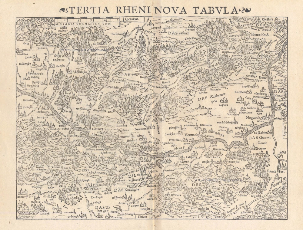
Tertia Rheni Nova Tabula 1542
Rheinland-Pfalz, by Sebastian Münster.
[Item number: 15390]
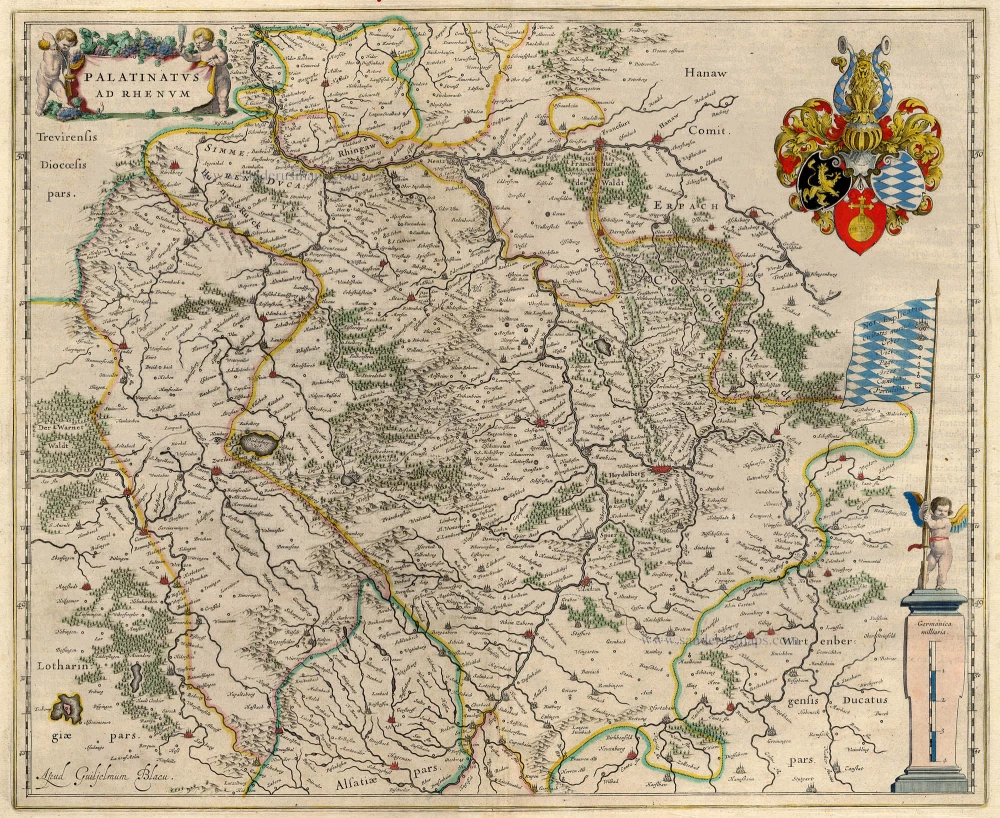
Palatinatus ad Rhenum. 1642-43
Rheinpfalz, by Blaeu W.
[Item number: 18718]
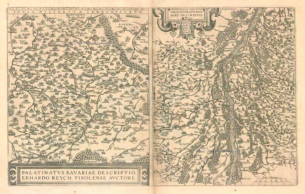
Palatinatus Bavariae Descriptio, Erhardo Reych Tirolense Auctore [on sheet with] Argentoratensis Agri Descriptio 1603
Oberpfalz and the vicinity of Strasbourg, by Ortelius A.
[Item number: 22834]
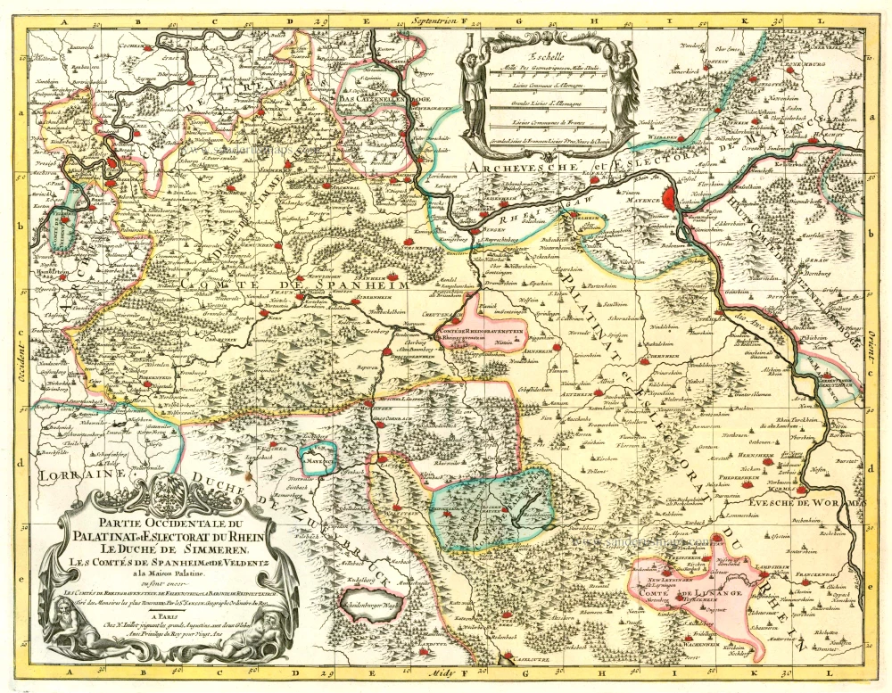
Partie Occidentale du Palatinat et Eslectorat du Rhein Le Duché de Simmeren, Les Comtés de Spanheim et de Veldentz à la Maison Palatine. 1710
Rheinland-Pfalz, by Covens & Mortier.
[Item number: 23829]
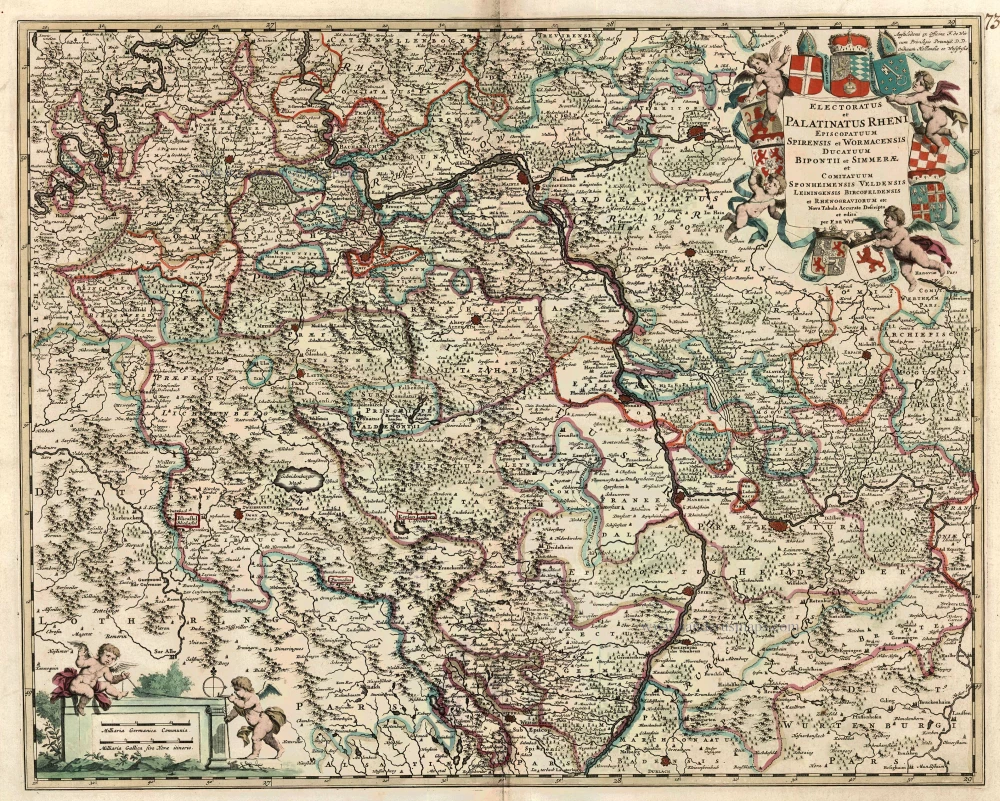
Electoratus et Palatinatus Rheni Episcopatuum Spirensis et Wormacensis Ducatuum Bipontii et Simmerae et Comitatuum Sponheimensis Veldensis Leiningensis Bircofeldensis et Rhenograviorum etc. c. 1680
Rheinland-Pfalz by Frederik De Wit.
[Item number: 24426]

Palatinatus Rheni 1623
Rheinpfalz , by G. Mercator.
[Item number: 24965]
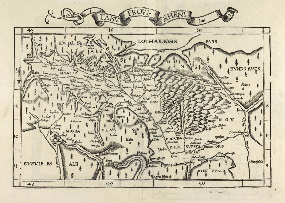
Tabu Provi. Rheni. 1525
Rheinland-Pfalz (Lorraine on verso) by Lorenz Fries.
[Item number: 28200]
Palatinatus Rheni Nova et Accurata Descriptio. 1656-80
Rheinland-Pfalz by Nicolaes Visscher I.
[Item number: 28592]

Exactissima Tabula Sedis Belli Palatinatus ad Rhenum, Vormaciensis et Spirensis Episcopatus, Bipontini Ducatus; sed etiam plurimae Moguntini Archiepiscopatus, et aliae adjacentes et insertae Regiones, distincte ostenduntur. c. 1716.
Rheinland-Pfalz by Nicolas Visscher II.
[Item number: 29657]
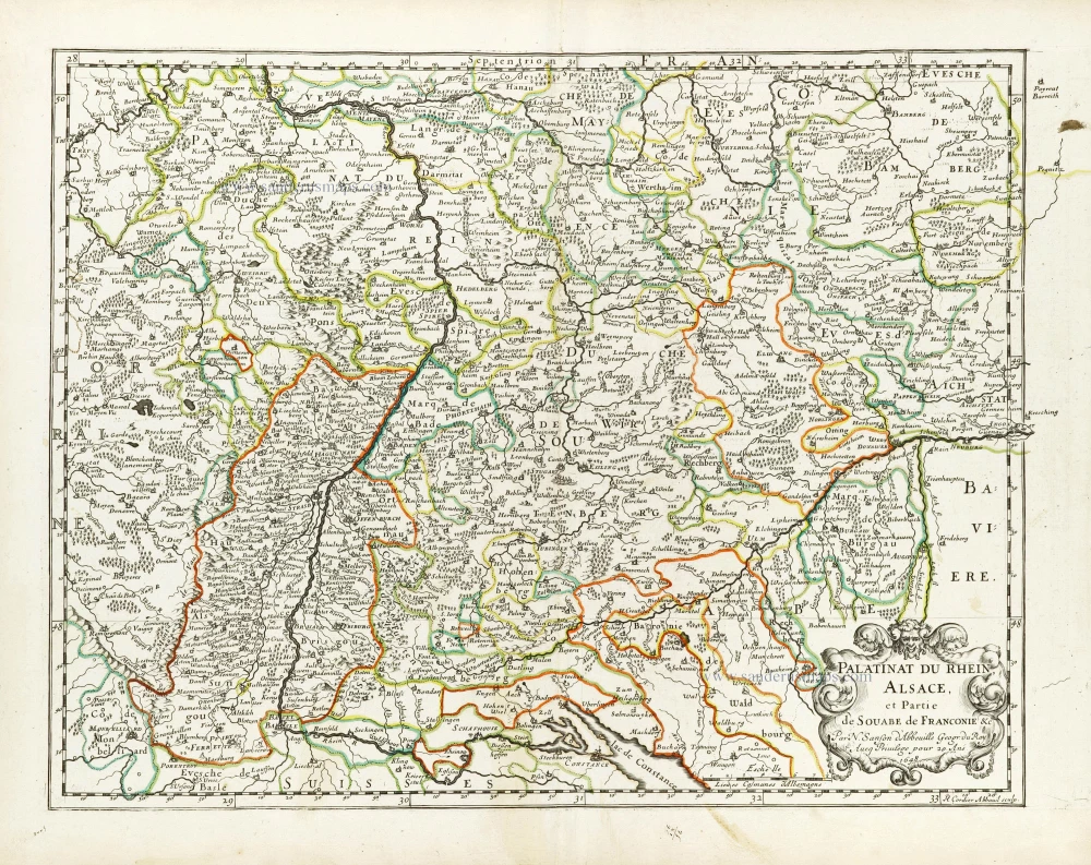
Palatinat du Rhein, Alsace, et Partie de Souabe de Franconie &c. 1652
Rheinland-Pfalz by Nicolas Sanson.
[Item number: 29696]