
Messina by Braun & Hogenberg 1574
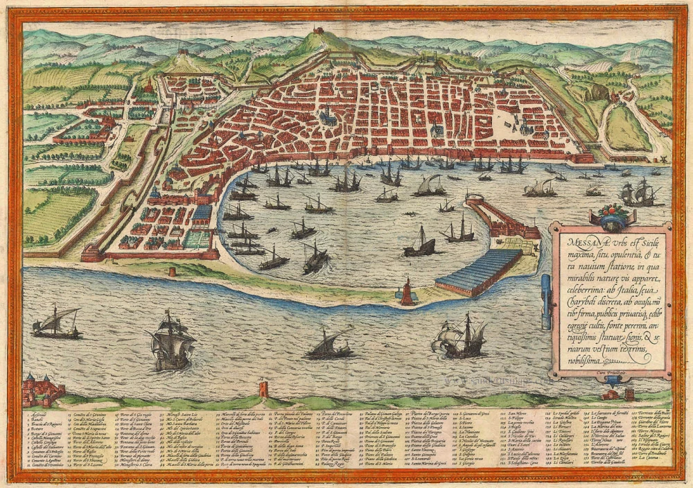
TRANSLATION OF CARTOUCHE TEXT: Messina, the largest city in Sicily, is famed for its position, wealth, and natural harbour. It is separated from Italy by the wild Charybdis. It is known for its well-kept public and private buildings, a perennial spring, ancient statues' remains, and silk cloth weaving.
COMMENTARY BY BRAUN: "Messina is a splendid and wealthy city separated from Italy by a stormy sea. It possesses a harbour that was not built by human hands but was carefully contrived by nature. Along the coast, shaped like a bow, the sea between Messina and Reggio di Calabria is very tempestuous, raging and extremely dangerous for seafarers. Very little wheat grows here, for the city is surrounded by mountains and the sea, but there are many bushes and trees whose best harvest is obtained from the mulberry leaves because the silkworms are fed from these. For the best silk in Europe is made in this city."
Messina is shown from the east, in a view of the crescent-shaped natural harbour and the city with its geometric plan. The image of Messina is dominated by the busy shipping in the harbour and the massive warehouses in the foreground. The city is well fortified and protected by citadels, particularly on its landward side. The 12th-century cathedral of Maria Santissima Assunta (17) stands in the town, with the fountain of Orion (29) in front of it by Giovanni Angelo Montorsoli. The Strait of Messina remains treacherous for shipping today. According to Greek mythology, its narrow channel held two sea monsters, both deadly to seafarers: Scylla, who dwelt in a rock on one side, and Charybdis, with his gaping whirlpool mouth on the other side. Since a tectonic fault runs through the Strait, Messina has regularly experienced seismic activity. (Taschen)
Braun G. & Hogenberg F. and the Civitates Orbis Terrarum.
The Civitates Orbis Terrarum, also known as the 'Braun & Hogenberg', is a six-volume town atlas and the most excellent book of town views and plans ever published: 363 engravings, sometimes beautifully coloured. It was one of the best-selling works in the last quarter of the 16th century. Georg Braun, a skilled writer, wrote the text accompanying the plans and views on the verso. Many plates were engraved after the original drawings of a professional artist, Joris Hoefnagel (1542-1600). The first volume was published in Latin in 1572 and the sixth in 1617. Frans Hogenberg, a talented engraver, created the tables for volumes I through IV, and Simon van den Neuwel made those for volumes V and VI. Other contributors were cartographers Daniel Freese and Heinrich Rantzau, who provided valuable geographical information. Works by Jacob van Deventer, Sebastian Münster, and Johannes Stumpf were also used as references. Translations appeared in German and French, making the atlas accessible to a broader audience.
Since its original publication of volume 1 in 1572, the Civitates Orbis Terrarum has left an indelible mark on the history of cartography. Seven more editions followed the first volume in 1575, 1577, 1582, 1588, 1593, 1599, and 1612. Vol.2, initially released in 1575, saw subsequent editions in 1597 and 1612. The subsequent volumes, each a treasure trove of historical insights, graced the world in 1581, 1588, 1593, 1599, and 1606. The German translation of the first volume, a testament to its widespread appeal, debuted in 1574, followed by the French edition in 1575.
Several printers were involved: Theodor Graminaeus, Heinrich von Aich, Gottfried von Kempen, Johannis Sinniger, Bertram Buchholtz, and Peter von Brachel, all of whom worked in Cologne.
Georg Braun (1541-1622)
Georg Braun, the author of the text accompanying the plans and views in the Civitates Orbis Terrarum, was born in Cologne in 1541. After his studies in Cologne, he entered the Jesuit Order as a novice, indicating his commitment to learning and intellectual pursuits. In 1561, he obtained his bachelor's degree; in 1562, he received his Magister Artium, further demonstrating his academic achievements. Although he left the Jesuit Order, he continued his studies in theology, gaining a licentiate in theology. His theological background likely influenced the content and tone of the text in the Civitates Orbis Terrarum, adding a unique perspective to the work.
Frans Hogenberg (1535-1590)
Frans Hogenberg was a Flemish and German painter, engraver, and mapmaker. He was born in Mechelen as the son of Nicolaas Hogenberg.
By the end of the 1560s, Frans Hogenberg was employed upon Abraham Ortelius's Theatrum Orbis Terrarum, published in 1570; he is named an engraver of numerous maps. In 1568, he was banned from Antwerp by the Duke of Alva and travelled to London, where he stayed a few years before emigrating to Cologne. He immediately embarked on his two most important works, the Civitates, published in 1572 and the Geschichtsblätter, which appeared in several series from 1569 until about 1587.
Thanks to large-scale projects like the Geschichtsblätter and the Civitates, Hogenberg's social circumstances improved with each passing year. He died as a wealthy man in Cologne in 1590.
Messana, Urbs est Sicilie maxima, situ, opulentia, & tuta navium statione, ...
Item Number: 5497 Authenticity Guarantee
Category: Antique maps > Europe > Italy - Cities
Old, antique bird’s-eye view plan of Sicily - Messina, by Georg Braun & Frans Hogenberg.
Title: Messana, Urbs est Sicilie maxima, situ, opulentia, & tuta navium statione, ...
Date of the first edition: 1572.
Date of this map: 1574.
Copper engraving, printed on paper.
Size (not including margins): 340 x 485mm (13.39 x 19.09 inches).
Verso: German text.
Condition: Original coloured, excellent.
Condition Rating: A+
From: Beschreibung und Contrafactur der Vornembster Stät der Welt. Köln, Heinrich von Ach, 1574. (Van der Krogt 4, 41:2.1)
TRANSLATION OF CARTOUCHE TEXT: Messina, the largest city in Sicily, is famed for its position, wealth, and natural harbour. It is separated from Italy by the wild Charybdis. It is known for its well-kept public and private buildings, a perennial spring, ancient statues' remains, and silk cloth weaving.
COMMENTARY BY BRAUN: "Messina is a splendid and wealthy city separated from Italy by a stormy sea. It possesses a harbour that was not built by human hands but was carefully contrived by nature. Along the coast, shaped like a bow, the sea between Messina and Reggio di Calabria is very tempestuous, raging and extremely dangerous for seafarers. Very little wheat grows here, for the city is surrounded by mountains and the sea, but there are many bushes and trees whose best harvest is obtained from the mulberry leaves because the silkworms are fed from these. For the best silk in Europe is made in this city."
Messina is shown from the east, in a view of the crescent-shaped natural harbour and the city with its geometric plan. The image of Messina is dominated by the busy shipping in the harbour and the massive warehouses in the foreground. The city is well fortified and protected by citadels, particularly on its landward side. The 12th-century cathedral of Maria Santissima Assunta (17) stands in the town, with the fountain of Orion (29) in front of it by Giovanni Angelo Montorsoli. The Strait of Messina remains treacherous for shipping today. According to Greek mythology, its narrow channel held two sea monsters, both deadly to seafarers: Scylla, who dwelt in a rock on one side, and Charybdis, with his gaping whirlpool mouth on the other side. Since a tectonic fault runs through the Strait, Messina has regularly experienced seismic activity. (Taschen)
Braun G. & Hogenberg F. and the Civitates Orbis Terrarum.
The Civitates Orbis Terrarum, also known as the 'Braun & Hogenberg', is a six-volume town atlas and the most excellent book of town views and plans ever published: 363 engravings, sometimes beautifully coloured. It was one of the best-selling works in the last quarter of the 16th century. Georg Braun, a skilled writer, wrote the text accompanying the plans and views on the verso. Many plates were engraved after the original drawings of a professional artist, Joris Hoefnagel (1542-1600). The first volume was published in Latin in 1572 and the sixth in 1617. Frans Hogenberg, a talented engraver, created the tables for volumes I through IV, and Simon van den Neuwel made those for volumes V and VI. Other contributors were cartographers Daniel Freese and Heinrich Rantzau, who provided valuable geographical information. Works by Jacob van Deventer, Sebastian Münster, and Johannes Stumpf were also used as references. Translations appeared in German and French, making the atlas accessible to a broader audience.
Since its original publication of volume 1 in 1572, the Civitates Orbis Terrarum has left an indelible mark on the history of cartography. Seven more editions followed the first volume in 1575, 1577, 1582, 1588, 1593, 1599, and 1612. Vol.2, initially released in 1575, saw subsequent editions in 1597 and 1612. The subsequent volumes, each a treasure trove of historical insights, graced the world in 1581, 1588, 1593, 1599, and 1606. The German translation of the first volume, a testament to its widespread appeal, debuted in 1574, followed by the French edition in 1575.
Several printers were involved: Theodor Graminaeus, Heinrich von Aich, Gottfried von Kempen, Johannis Sinniger, Bertram Buchholtz, and Peter von Brachel, all of whom worked in Cologne.
Georg Braun (1541-1622)
Georg Braun, the author of the text accompanying the plans and views in the Civitates Orbis Terrarum, was born in Cologne in 1541. After his studies in Cologne, he entered the Jesuit Order as a novice, indicating his commitment to learning and intellectual pursuits. In 1561, he obtained his bachelor's degree; in 1562, he received his Magister Artium, further demonstrating his academic achievements. Although he left the Jesuit Order, he continued his studies in theology, gaining a licentiate in theology. His theological background likely influenced the content and tone of the text in the Civitates Orbis Terrarum, adding a unique perspective to the work.
Frans Hogenberg (1535-1590)
Frans Hogenberg was a Flemish and German painter, engraver, and mapmaker. He was born in Mechelen as the son of Nicolaas Hogenberg.
By the end of the 1560s, Frans Hogenberg was employed upon Abraham Ortelius's Theatrum Orbis Terrarum, published in 1570; he is named an engraver of numerous maps. In 1568, he was banned from Antwerp by the Duke of Alva and travelled to London, where he stayed a few years before emigrating to Cologne. He immediately embarked on his two most important works, the Civitates, published in 1572 and the Geschichtsblätter, which appeared in several series from 1569 until about 1587.
Thanks to large-scale projects like the Geschichtsblätter and the Civitates, Hogenberg's social circumstances improved with each passing year. He died as a wealthy man in Cologne in 1590.
Related items

Messina Ville de la Sicile. 1704
Sicily - Messina, by Blaeu - Mortier.
[Item number: 18139]

Messana, Urbs est Sicilie maxima, situ, opulentia, & tuta navium statione, ... 1612
Messina in Sicily, by Georg Braun and Frans Hogenberg.
[Item number: 22348]

Insularum Aliquot Maris Mediterranei Descriptio. 1592
Sicily, Sardinia, Corfu, Zerbi, Elba, Malta by Abraham Ortelius.
[Item number: 23053]
Regni & Insulae Siciliae Tabula Geographica ... c. 1720-65
Sicily, by Homann Heirs.
[Item number: 25478]

Isle et Royaume de Sicile. 1665
Sicily, by N. & G. Sanson.
[Item number: 25896]
Messina. 1638
Messina, by M. Merian.
[Item number: 26033]

In rare original colour.
L'Ile de Sicile. 1713
Sicily, by Pieter Van der Aa.
[Item number: 26077]

Messina Colle Nuove Fortificationi. 1696
Messina by Vincenzo Coronelli.
[Item number: 28714]

Sicilia Regnum. 1650
Sicily (Sicilia), by Willem & Joan Blaeu.
[Item number: 28774]
Sicilia - [Above map :] Descrittione dell'Isola di Sicilia. 1590
Sicily (Sicilia) by Thomaso Porcacchi.
[Item number: 29766]
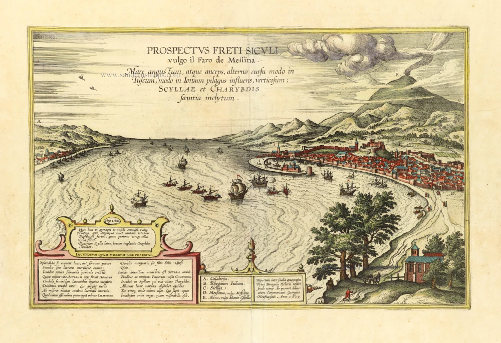
Prospectus Freti Siculi vulgo il Faro di Messina. 1657
The Strait of Messina, by Georg Braun & Frans Hogenberg, after a drawing by Pieter Brueghel, adapted by Georg Hoefnagel, published by J. Janssonius.
[Item number: 31822]

Sicilia. 1618
Sicily (Sicilia) by Petrus Bertius, published by Jodocus Hondius II.
[Item number: 31860]

Famous view after Pieter Breugel
Prospectus Freti Siculi vulgo il Faro di Messina. 1635
Strait of Messina by Braun & Hogenberg
[Item number: 31875]
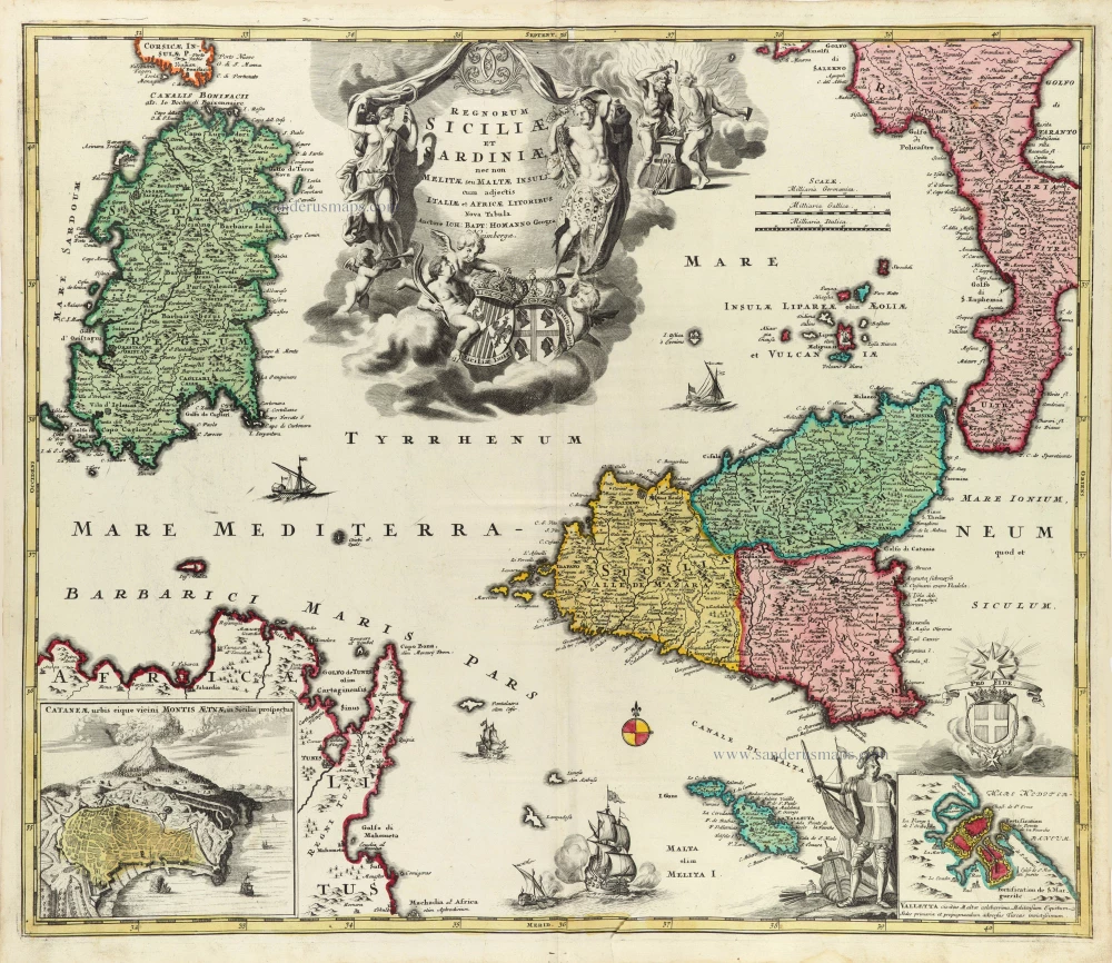
Regnorum Siciliae et Sardiniae nec non Melitae seu Maltae insuli cum adjectis Italiae et Africae Litoribus Nova Tabula. c. 1720
Sicily - Sardinia, by J.B. Homann.
[Item number: 32164]

Tabula Moderna Italie. 1525
Corsica, Sardinia, and Sicilia (Sicily), by Lorenz Fries.
[Item number: 32732]
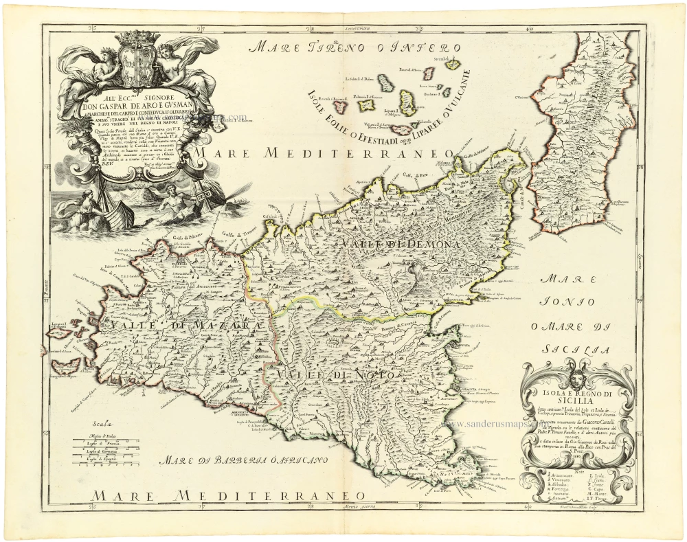
Isola e Regno di Sicilia 1684
Sicilia, by Giacomo Cantelli da Vignola, published by Giovanni de Rossi.
[Item number: 32915]

Parergon map
Siciliae Veteris Typus. 1592
Ancient Sicily, by Abraham Ortelius.
[Item number: 33064]
new

Insula sive Regnum Siciliae Urbibus praecipuis exornatum 1682-88
Sicily by Frederick de Wit.
[Item number: 33168]
new