
Northwest Italy by Nicolas Sanson. 1652
SANSON FAMILY
Nicolas Sanson (1600-1667) - Guillaume Sanson (1633-1703) - Pierre Moullart-Sanson (? -1730)
Originally from Abbeville, Nicolas I Sanson showed a keen interest in historical geography. He was still very young; he published a map of ancient Gaul and two treatises, Britannia and Portus Itius on Abbeville and Boulogne's origins. His meeting with Melchior Tavernier was decisive: it prompted him to give up his duties as a military engineer in Picardy and devote himself to engraved cartography.
At the same time, Sanson had drawn up the outline of modern France. He got the help of Tavernier, who encouraged him to compete with the Dutch map publishers. Tavernier contacted other French cartographers whose works he published.
From 1643, N. Sanson obtained a privilege to publish a work personally, the Princes souverains de l'Italie. Then, in 1644 and 1645, he had his famous geographical tables printed, which significantly contributed to his fame. He also published a series of atlases in quarto of the four continents.
In 1648, N. Sanson associated himself with Mariette to publish atlases. From then on, specific maps bore his name and others Mariette's. N. Sanson and Mariette worked together for more than 20 years. After the death of N. Sanson, Mariette acquired the entire fund. Since Mariette only wanted to publish complete atlases, individual maps were no longer sold, and some army generals complained to the king.
The disagreement between the Sanson family and Pierre II Mariette culminated in 1671 when Guillaume Sanson took the case to court. There was no longer any question of collaboration: Guillaume Sanson started working for another publisher, Alexis-Hubert Jaillot.
The Sanson family faced financial difficulties, and in 1692, their cousin, Pierre Moullart-Sanson, bought the entire geographic fund from his uncles and aunt. Pierre Moullart-Sanson was the son of Françoise Sanson (third child of Nicolas) and Pierre Moullart. He restarted the publishing of Sanson's world atlas, and in 1704 he acquired a privilege for publishing all the works of Nicolas and Guillaume Sanson, which continued to be published until 1730.
Pierre Mariette (1602-1658)
Bookseller, printseller, printer, and publisher, located in the Rue Saint-Jacques in Paris. On February 12, 1644, Pierre Mariette acquired most of Melchior Tavernier's fund. In 1646, he had a series of maps by Blaeu copied and asked Abraham Peyrounin to engrave them. In the meantime, he published the works of Nicolas Sanson. In 1650, he published the atlas Théâtre Géographique de France. A second edition followed in 1653. He later contributed to Sanson's atlas, the Cartes générales de toutes les parties du monde. Many maps of Mariette's Théatre appeared in later editions of Sanson's Cartes générales.
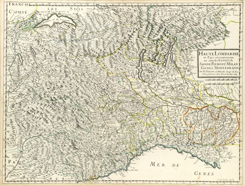
Haute Lombardie et Pays Circomvoisins, ou sont les Estats de Savoye, Piemont, Milan, Genes, Monferrat, &c.
Item Number: 29719 Authenticity Guarantee
Category: Antique maps > Europe > Italy
Old, antique map of Northwest Italy by Nicolas Sanson.
Title: Haute Lombardie et Pays Circomvoisins, ou sont les Estats de Savoye, Piemont, Milan, Genes, Monferrat, &c.
Par N. Sanson d'Abbeville Geogr. du Roy
Chez l'Auteur Avec Privil. du Roy 1648.
A. de la plaes Sculcit.
Engraver: A. de la Plaes.
Date of the first edition: 1648.
Date of this map: 1652.
Date on map: 1648.
Copper engraving, printed on paper.
Map size: 425 x 560mm (16.73 x 22.05 inches).
Sheet size: 435 x 570mm (17.13 x 22.44 inches).
Verso: Blank.
Condition: Original coloured in outline, excellent.
Condition Rating: A+.
From: Atlas with Sanson maps, without a title page, published by Pierre Mariette. 1652.
Pastoureau, p. 401: "En 1652, on les voit [les cartes de Sanson] pour la première fois réunies en un recueil sans titre, mais dont la structure est celle d'un atlas du monde. Ce recueil, daté par son ex-libris, contient 70 cartes dont 14 de géographie ancienne." (In 1652, we see them [Sanson's maps] for the first time brought together in an untitled collection, but whose structure is that of a world atlas. This collection, dated by its ex-libris, contains 70 maps including 14 of ancient geography.)
SANSON FAMILY
Nicolas Sanson (1600-1667) - Guillaume Sanson (1633-1703) - Pierre Moullart-Sanson (? -1730)
Originally from Abbeville, Nicolas I Sanson showed a keen interest in historical geography. He was still very young; he published a map of ancient Gaul and two treatises, Britannia and Portus Itius on Abbeville and Boulogne's origins. His meeting with Melchior Tavernier was decisive: it prompted him to give up his duties as a military engineer in Picardy and devote himself to engraved cartography.
At the same time, Sanson had drawn up the outline of modern France. He got the help of Tavernier, who encouraged him to compete with the Dutch map publishers. Tavernier contacted other French cartographers whose works he published.
From 1643, N. Sanson obtained a privilege to publish a work personally, the Princes souverains de l'Italie. Then, in 1644 and 1645, he had his famous geographical tables printed, which significantly contributed to his fame. He also published a series of atlases in quarto of the four continents.
In 1648, N. Sanson associated himself with Mariette to publish atlases. From then on, specific maps bore his name and others Mariette's. N. Sanson and Mariette worked together for more than 20 years. After the death of N. Sanson, Mariette acquired the entire fund. Since Mariette only wanted to publish complete atlases, individual maps were no longer sold, and some army generals complained to the king.
The disagreement between the Sanson family and Pierre II Mariette culminated in 1671 when Guillaume Sanson took the case to court. There was no longer any question of collaboration: Guillaume Sanson started working for another publisher, Alexis-Hubert Jaillot.
The Sanson family faced financial difficulties, and in 1692, their cousin, Pierre Moullart-Sanson, bought the entire geographic fund from his uncles and aunt. Pierre Moullart-Sanson was the son of Françoise Sanson (third child of Nicolas) and Pierre Moullart. He restarted the publishing of Sanson's world atlas, and in 1704 he acquired a privilege for publishing all the works of Nicolas and Guillaume Sanson, which continued to be published until 1730.
Pierre Mariette (1602-1658)
Bookseller, printseller, printer, and publisher, located in the Rue Saint-Jacques in Paris. On February 12, 1644, Pierre Mariette acquired most of Melchior Tavernier's fund. In 1646, he had a series of maps by Blaeu copied and asked Abraham Peyrounin to engrave them. In the meantime, he published the works of Nicolas Sanson. In 1650, he published the atlas Théâtre Géographique de France. A second edition followed in 1653. He later contributed to Sanson's atlas, the Cartes générales de toutes les parties du monde. Many maps of Mariette's Théatre appeared in later editions of Sanson's Cartes générales.
Related items
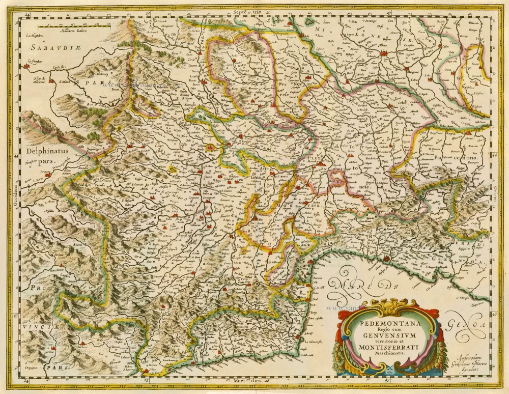
Pedemontana Regio cum Genvensium territorio et Montisferrati Marchionatu. 1635
Piemonte, by W. Blaeu.
[Item number: 20371]

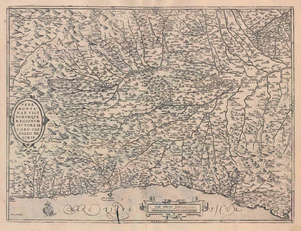
Pedemontanae Vicinorumquae Regionum. 1601
Piemonte, by Abraham Ortelius.
[Item number: 21259]
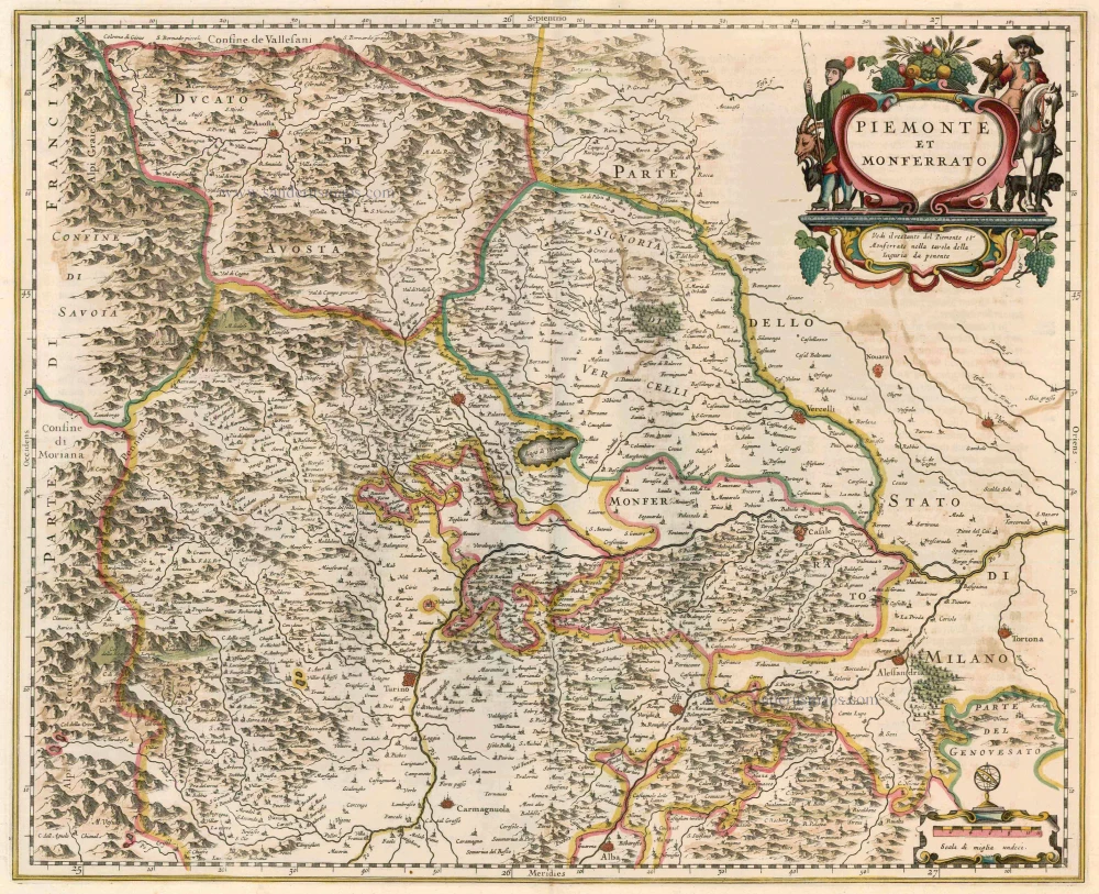
Piemonte et Monferrato 1644-58
Piemonte - Monferrato, by Janssonius J. - Hondius H.
[Item number: 22847]
Pedemontanae Vicinorumquae Regionum 1612
Piemonte, by Abraham Ortelius.
[Item number: 23019]

Theatre de la Guerre en Savoie et en Piémont - Le Dauphiné, La Bresse - Partie du Lionnois et de la Provence. 1721-41
Piedmont (Piemonte) and Savoy, by Covens & Mortier.
[Item number: 23544]

Levée du Siège de Coni Ville de Piemont Assiégée par les François & Secouru par le Serenissime Prince Eugene de Savoye General des Troupes de l'Empereur en 1691. 1729
The Battle of Cuneo (Piemonte) after Jan van Huchtenburg.
[Item number: 25965]

Le Piemont. 1713
Piedmont (Piemonte), by Pieter Van der Aa.
[Item number: 26093]

Stato del Piemonte. 1640
Piemonte, by Willem & Joan Blaeu
[Item number: 27207]

Carte qui contient la Principauté de Piémont, Le Montferrat, et la Comté de Nice, avec la rivière de Ponent de Gènes. 1776-79
Piemonte and Montferrat, by Paolo Santini.
[Item number: 27708]

Status Belli Italiam inter et Galliam Comprehendens Sabaudiae Ducatum Pedemontii Princip. et Nicaeensem Comitatum Partemque Delphinatus et Provinciae etc. after 1721
Piemonte & Valle d'Aosta by Frederik de Wit, published by Covens & Mortier.
[Item number: 28324]
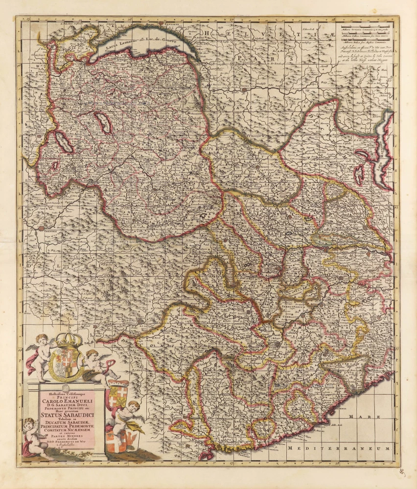
Illustrissimo Celsissimoque Principi Carolo Emanueli D.G. Sabaudiae Duci, Pedemontii Principi etc. Hanc accuratam Status Sabaudici Tabulam in Ducatum Sabaudiae, Principatum Pedemontii, Comitatum Nicaeensem et caeteras Partes Minores exacte divisam. c. 1690
Duchy of Savoie and Piemonte by Frederick de Wit.
[Item number: 28790]

Piemonte et Monferrato. 1649-50
Piemonte, by Joan Blaeu.
[Item number: 28894]

Belli Typus in Italia, victricis Aquilae progreßus in Statu Mediolanensi et Ducatu Mantuae demonstrans. c. 1720
Northwest Italy, by J.B. Homann.
[Item number: 32301]

Rare
Téatre dela Guerre en Italie ou Partie dela République de Venise Verone, Mantoue, Modene Padoue &c. c. 1700
Northwest Italy by Pierre Mortier.
[Item number: 32615]