
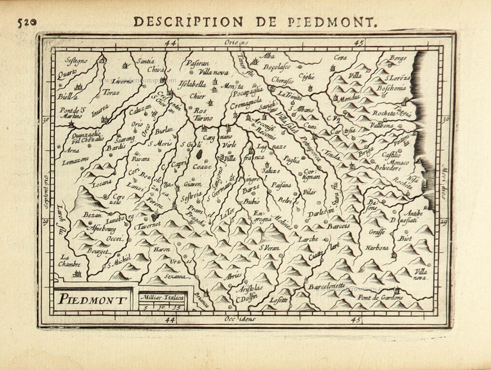
Piemonte, by Abraham Ortelius. 1601

Abraham Ortelius (1527-1598)
The maker of the 'first atlas', the Theatrum Orbis Terrarum (1570), was born on 4 April 1527 into an old Antwerp family. He learned Latin and studied Greek and mathematics.
Abraham and his sisters, Anne and Elizabeth, took up map colouring. Ortelius was admitted to the Guild of St. Luke as an "illuminator of maps." In addition to colouring maps, Ortelius was a dealer in antiques, coins, maps, and books, and the book and map trade gradually became his primary occupation.
Business went well because his means allowed him to amass an extensive collection of medals, coins, and antiques, as well as a library of many volumes. In addition, he travelled extensively, visited Italy and France, made contacts with scholars and editors everywhere, and maintained extensive correspondence with them.
In 1564, he published his first map, a large and ambitious world wall map. The inspiration for this map may well have been Gastaldi's large world map. In 1565, he published a map of Egypt and a map of the Holy Land; a large map of Asia followed.
In 1568, the production of individual maps for his atlas Theatrum Orbis Terrarum was already in full swing. He completed the atlas in 1569, and in May 1570, it was available for sale. It was one of the most expensive books ever published.
This first edition contained seventy maps on fifty-three sheets. Franciscus Hogenberg engraved the maps.
Later editions included Additamenta (additions), resulting in Ortelius' historical atlas, the Parergon, which is mainly bound together with the atlas. The Parergon can be considered a truly original work by Ortelius, who drew the maps based on his research.
The importance of the Theatrum Orbis Terrarum for geographical knowledge in the last quarter of the sixteenth century is difficult to overemphasise. Nothing was like it until Mercator's atlas appeared twenty-five years later. Demand for the Theatrum was remarkable. Some 24 editions appeared during Ortelius's lifetime, and another 10 after he died in 1598. Editions were published in Dutch, German, French, Spanish, English, and Italian. The number of map sheets grew from 53 in 1570 to 167 in the last edition in 1612.
In 1577, engraver Philip Galle and poet-translator Pieter Heyns published the first pocket-sized edition of the Theatrum, the Epitome. The work was trendy. Over thirty editions of this Epitome were published in different languages.
Ortelius is also remembered for an early idea resembling continental drift: he suggested that the Americas, Europe, and Africa may once have been joined together before separating over time. His work helped shape the development of modern geography and mapmaking.
Giacomo Gastaldi (c. 1500 – 1566)
Giacomo Gastaldi was born in Villafranca, in Piedmont, to a wealthy family. Although he is considered one of the greatest cartographers of the sixteenth century, the events of his life and his professional training in the field of cartography are unknown to us until he arrives in Venice, where, in 1539, he obtained a perpetual printing privilege from the Venetian Senate.
One of the first Venetian contacts took place with the geographer and humanist Giovanni Battista Ramusio, with whom he collaborated. At the beginning of the 1540s, Gastaldi was already an established cartographer and began to work on a series of maps first published separately and then included in the Italian edition of Ptolemy's Geography of 1548 and others made from scratch.
By the 1540s, he had developed his distinctive style of copper engraving for his increasingly prolific output of maps. His maps were used as a source by many mapmakers, including Camocio, Bertelli, Forlani, Ramusio, Cock, Luchini and Ortelius.
With the support of his influential friendships, Gastaldi also obtained public positions: in 1549, the Council of Ten commissioned him to make a large map of Africa, for a wall from the armoury in the Doge's Palace and, again for the same room, one map of Asia and one of North America.
It is difficult to quantify the number of maps he produced; more than a hundred have been attributed to him.
Paolo Forlani collaborated for a long time with Gastaldi and published numerous counterfeits and not authorized editions.
Gastaldi died in Venice on 14 October 1566.
Pedemontanae Vicinorumquae Regionum.
Item Number: 21259 Authenticity Guarantee
Category: Antique maps > Europe > Italy
Old, antique map of Piemonte by Abraham Ortelius.
Title: Pedemontanae Vicinorumquae Regionum.
Cartographer: Giacomo Gastaldi.
Date of the first edition: 1570.
Date of this map: 1601.
Copper engraving, printed on paper.
Size (not including margins): 370 x 495mm (14.57 x 19.49 inches).
Verso: Latin text.
Condition: Original coloured, excellent.
Condition Rating: A+.
From: Ortelius A.,Theatrum Orbis Terrarum Abrahami Ortelii Antverp. Geographi Regii. Antwerpen, Plantin Press, 1601. (Van der Krogt 3, 1:052)
Abraham Ortelius (1527-1598)
The maker of the 'first atlas', the Theatrum Orbis Terrarum (1570), was born on 4 April 1527 into an old Antwerp family. He learned Latin and studied Greek and mathematics.
Abraham and his sisters, Anne and Elizabeth, took up map colouring. Ortelius was admitted to the Guild of St. Luke as an "illuminator of maps." In addition to colouring maps, Ortelius was a dealer in antiques, coins, maps, and books, and the book and map trade gradually became his primary occupation.
Business went well because his means allowed him to amass an extensive collection of medals, coins, and antiques, as well as a library of many volumes. In addition, he travelled extensively, visited Italy and France, made contacts with scholars and editors everywhere, and maintained extensive correspondence with them.
In 1564, he published his first map, a large and ambitious world wall map. The inspiration for this map may well have been Gastaldi's large world map. In 1565, he published a map of Egypt and a map of the Holy Land; a large map of Asia followed.
In 1568, the production of individual maps for his atlas Theatrum Orbis Terrarum was already in full swing. He completed the atlas in 1569, and in May 1570, it was available for sale. It was one of the most expensive books ever published.
This first edition contained seventy maps on fifty-three sheets. Franciscus Hogenberg engraved the maps.
Later editions included Additamenta (additions), resulting in Ortelius' historical atlas, the Parergon, which is mainly bound together with the atlas. The Parergon can be considered a truly original work by Ortelius, who drew the maps based on his research.
The importance of the Theatrum Orbis Terrarum for geographical knowledge in the last quarter of the sixteenth century is difficult to overemphasise. Nothing was like it until Mercator's atlas appeared twenty-five years later. Demand for the Theatrum was remarkable. Some 24 editions appeared during Ortelius's lifetime, and another 10 after he died in 1598. Editions were published in Dutch, German, French, Spanish, English, and Italian. The number of map sheets grew from 53 in 1570 to 167 in the last edition in 1612.
In 1577, engraver Philip Galle and poet-translator Pieter Heyns published the first pocket-sized edition of the Theatrum, the Epitome. The work was trendy. Over thirty editions of this Epitome were published in different languages.
Ortelius is also remembered for an early idea resembling continental drift: he suggested that the Americas, Europe, and Africa may once have been joined together before separating over time. His work helped shape the development of modern geography and mapmaking.
Giacomo Gastaldi (c. 1500 – 1566)
Giacomo Gastaldi was born in Villafranca, in Piedmont, to a wealthy family. Although he is considered one of the greatest cartographers of the sixteenth century, the events of his life and his professional training in the field of cartography are unknown to us until he arrives in Venice, where, in 1539, he obtained a perpetual printing privilege from the Venetian Senate.
One of the first Venetian contacts took place with the geographer and humanist Giovanni Battista Ramusio, with whom he collaborated. At the beginning of the 1540s, Gastaldi was already an established cartographer and began to work on a series of maps first published separately and then included in the Italian edition of Ptolemy's Geography of 1548 and others made from scratch.
By the 1540s, he had developed his distinctive style of copper engraving for his increasingly prolific output of maps. His maps were used as a source by many mapmakers, including Camocio, Bertelli, Forlani, Ramusio, Cock, Luchini and Ortelius.
With the support of his influential friendships, Gastaldi also obtained public positions: in 1549, the Council of Ten commissioned him to make a large map of Africa, for a wall from the armoury in the Doge's Palace and, again for the same room, one map of Asia and one of North America.
It is difficult to quantify the number of maps he produced; more than a hundred have been attributed to him.
Paolo Forlani collaborated for a long time with Gastaldi and published numerous counterfeits and not authorized editions.
Gastaldi died in Venice on 14 October 1566.
Related items
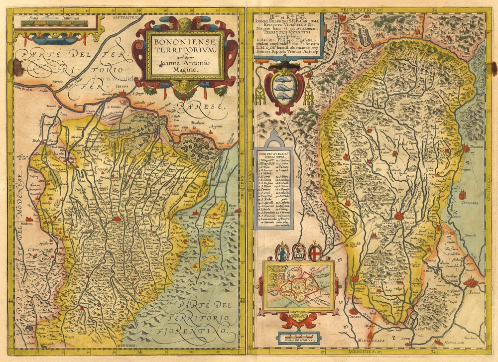
Bononiense Territorium [on sheet with] Territori Vicentini. 1612
Bologna and Vicenza by Ortelius A.
[Item number: 1034]
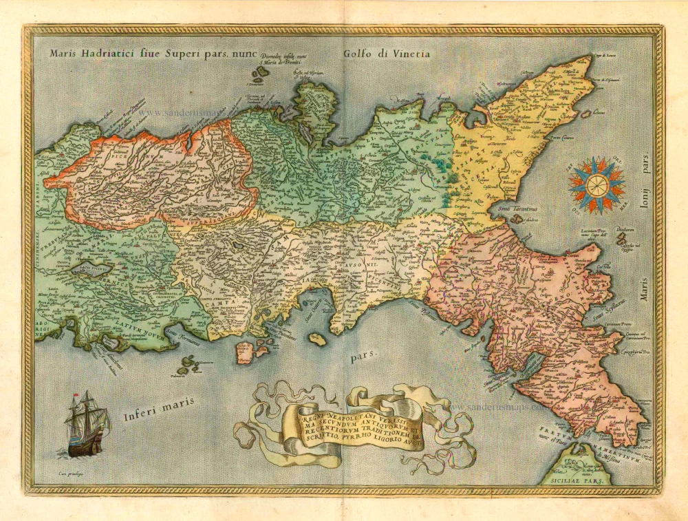
Regni Neapolitani Verissima Secundum Antiquorum et Recentiorum Traditionem Descriptio, Pyrrho Ligorio Auct. 1601
Napoli (Naples), by A. Ortelius.
[Item number: 8072]
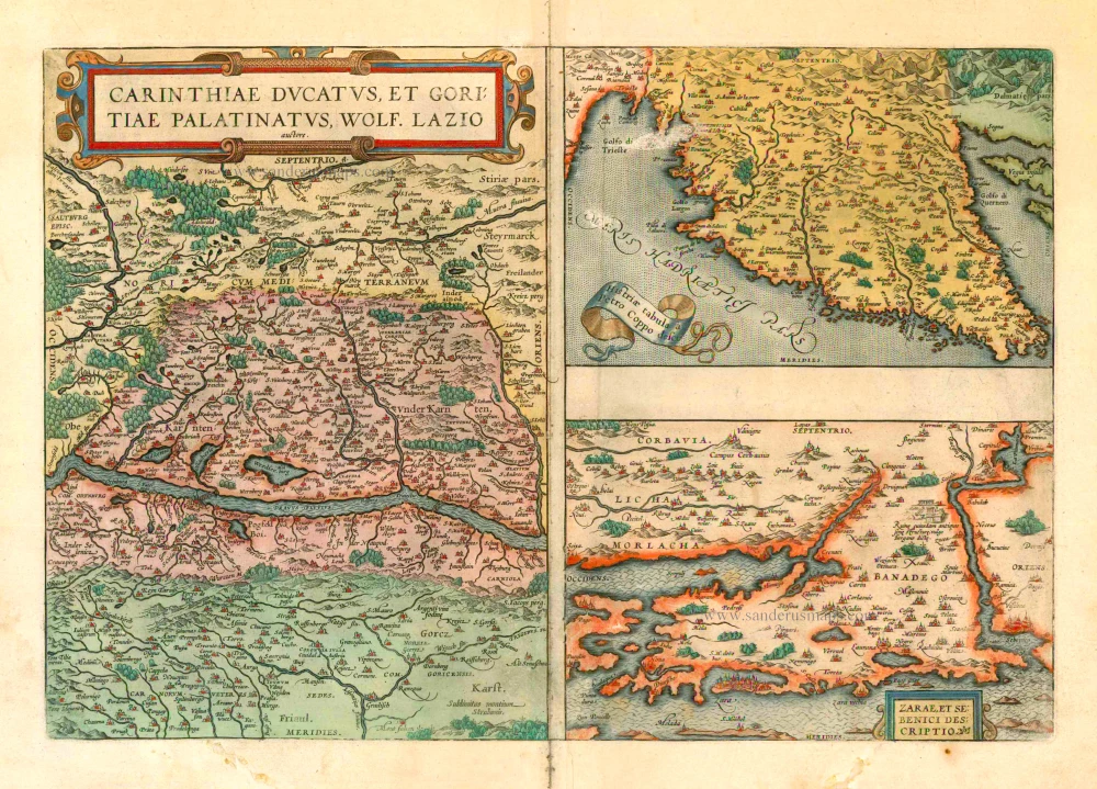
Carinthiae Ducatus - Histriae Tabula - Zarae et Sebenici Descriptio 1601
Kärnten and Istria, by A. Ortelius.
[Item number: 8083]

Latium. 1601
Lazio by Abraham Ortelius
[Item number: 12421]

Latium. 1601
Lazio, by A. Ortelius.
[Item number: 22666]
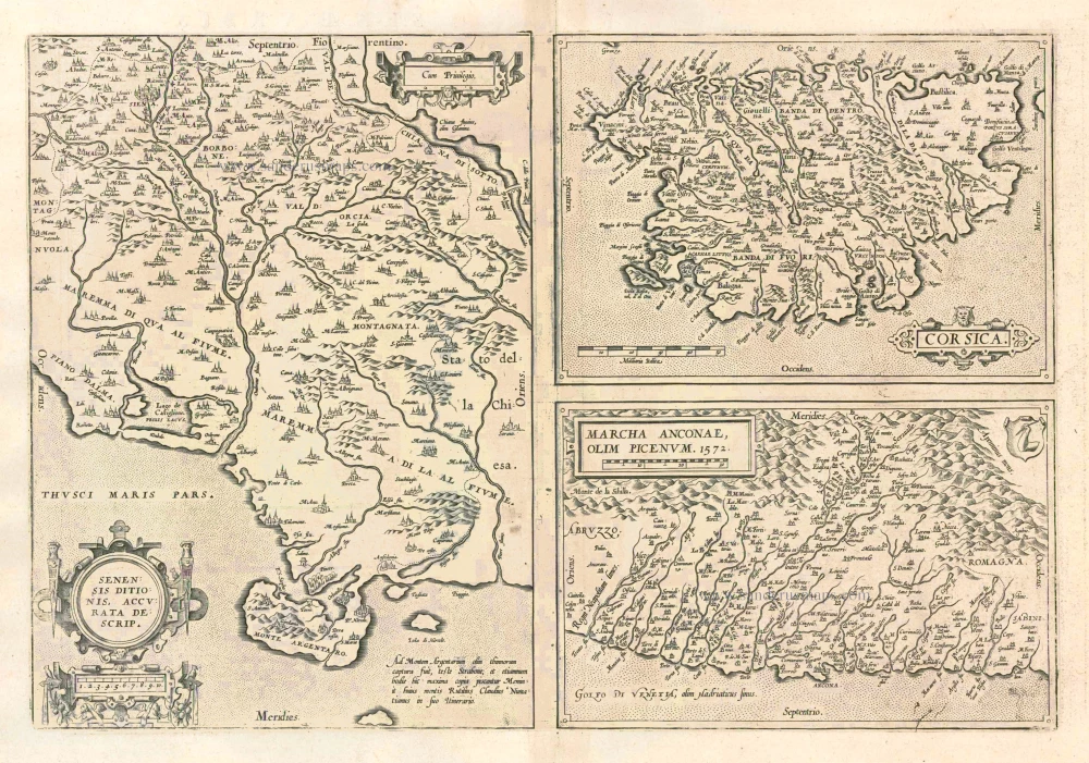
Senensis Ditionis - Corsica - Marcha Anconae olim Picenum. 1572. 1612
Siena - Corsica - Ancona, by Ortelius A.
[Item number: 22975]

Patavini Territorii Corographia [on sheet with:] Tarvisini Agri Typus. 1612
Padova and Tarviso, by Abraham Ortelius.
[Item number: 23123]
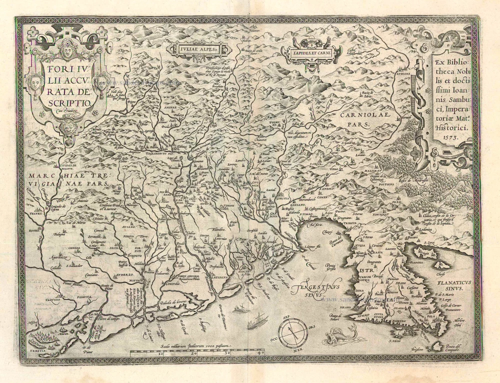
Fori Iulii Accurata Descriptio 1612
Friuli, by A. Ortelius.
[Item number: 23125]

Pedemontana Regio Cum Genuensium Territorio & Montisferrati Marchionatu. 1623
Lombardy (Southwest), by Gerard Mercator.
[Item number: 24924]

Le Piemont. 1713
Piedmont (Piemonte), by Pieter Van der Aa.
[Item number: 26093]

Stato del Piemonte. 1640
Piemonte, by Willem & Joan Blaeu
[Item number: 27207]

Status Belli Italiam inter et Galliam Comprehendens Sabaudiae Ducatum Pedemontii Princip. et Nicaeensem Comitatum Partemque Delphinatus et Provinciae etc. after 1721
Piemonte & Valle d'Aosta by Frederik de Wit, published by Covens & Mortier.
[Item number: 28324]
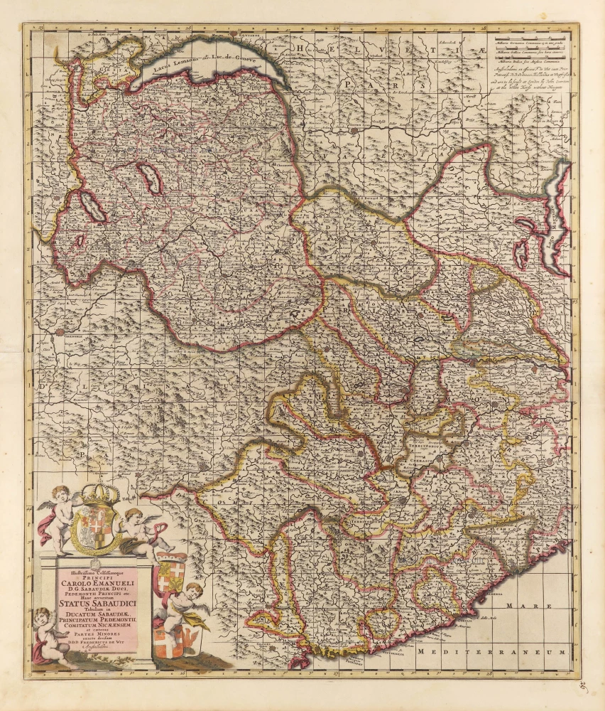
Illustrissimo Celsissimoque Principi Carolo Emanueli D.G. Sabaudiae Duci, Pedemontii Principi etc. Hanc accuratam Status Sabaudici Tabulam in Ducatum Sabaudiae, Principatum Pedemontii, Comitatum Nicaeensem et caeteras Partes Minores exacte divisam. c. 1690
Duchy of Savoie and Piemonte by Frederick de Wit.
[Item number: 28790]

Piemonte et Monferrato. 1649-50
Piemonte, by Joan Blaeu.
[Item number: 28894]
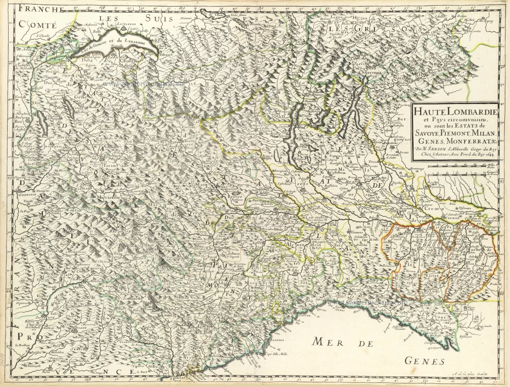
Haute Lombardie et Pays Circomvoisins, ou sont les Estats de Savoye, Piemont, Milan, Genes, Monferrat, &c. 1652
Northwest Italy by Nicolas Sanson.
[Item number: 29719]

Pedemontana Regio, cum Genuensium territorio et Montifferrati Marchionatu. 1607
Piemonte, Liguria, and Monferrato by Gerard Mercator, published by Jodocus Hondius.
[Item number: 31458]
Piemont. 1618
Piemonte by Petrus Bertius, published by Jodocus Hondius II.
[Item number: 31635]

Regiae Celsitudinis Sabaudicae Status in quo Ducatus Sabaudiae Principatus Pedemontium et Ducatus Montisferrati in suas quasq. Ditiones & Territoria divisi cum finitimis Regionibus exhibentur. c. 1720
Piemonte, Liguria, and Monferrato, by J.B. Homann.
[Item number: 32276]