
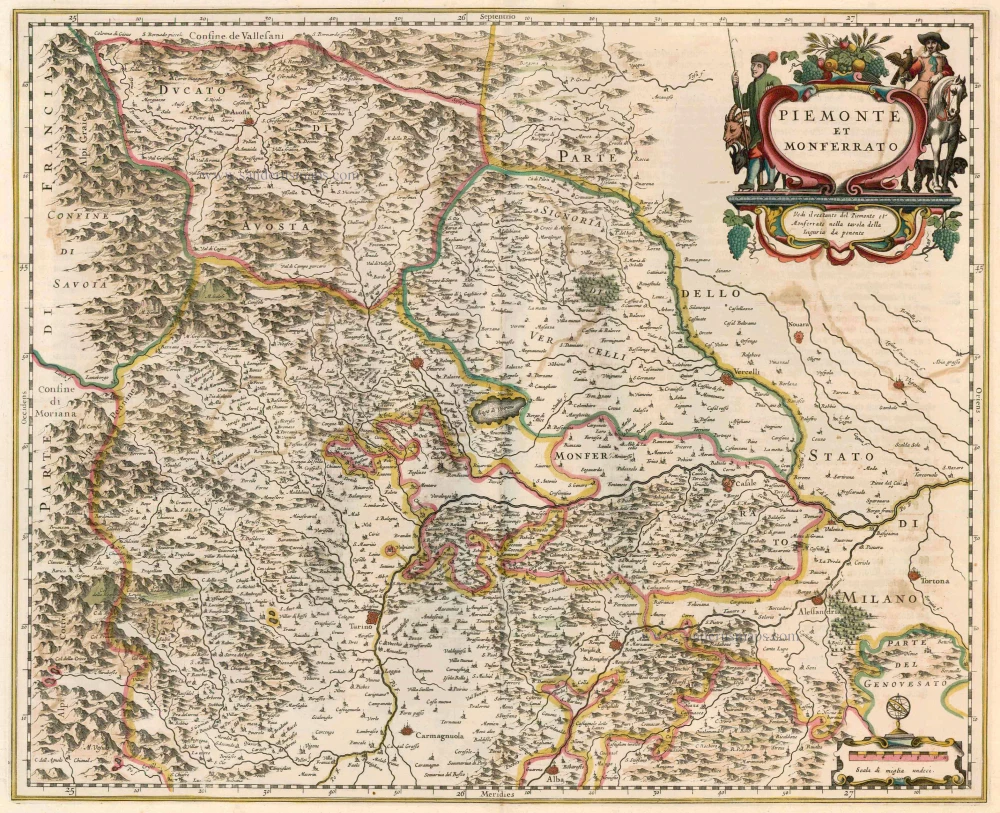
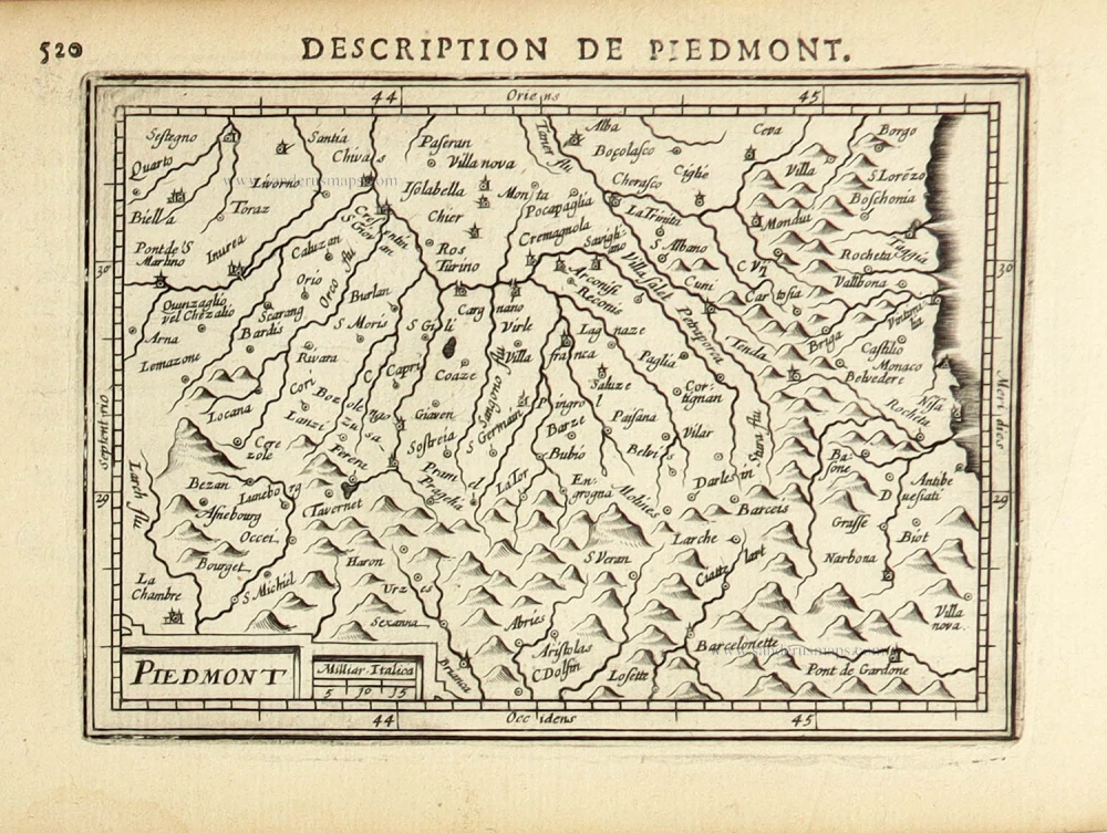
Piemonte, by Joan Blaeu. 1649-50

The Blaeus: Willem Janszoon, Cornelis & Joan
Willem Jansz. Blaeu and his son Joan Blaeu are the seventeenth century's most widely known cartographic publishers.
Willem Jansz. (also written Guilielmus Janssonius) = Willem Janszoon Blaeu was born in Uitgeest (Netherlands), near Alkmaar, in 1571. He studied mathematics under Tycho Brahe and learned the theory and practice of astronomical observations and the art of instrument- and globe-making.
In 1596, he came to Amsterdam, where he settled down as a globe-, instrument- and mapmaker. He published his first cartographic work (a globe) in 1599 and probably published his first printed map (a map of the Netherlands) in 1604. He specialised in maritime cartography, published the first edition of the pilot guide Het Licht der Zeevaert in 1608, and was appointed Hydrographer of the V.O.C. (United East India Company) in 1633. After publishing books, wall maps, globes, charts and pilot guides for thirty years, he brought out his first atlas, Atlas Appendix (1630). This was the beginning of the great tradition of atlas-making by the Blaeus.
In 1618, another mapmaker, bookseller and publisher, Johannes Janssonius, established himself in Amsterdam next door to Blaeu's shop. No wonder these two neighbours began accusing each other of copying and stealing their information and became fierce competitors who did not have a good word to say about each other. In about 1621 Willem Jansz. decided to end the confusion between his name and his competitor's and assumed his grandfather's nickname, 'blauwe Willem' ('blue Willem'), as the family name; after that, he called himself Willem Jansz. Blaeu.
Willem Janszoon Blaeu died in 1638, leaving his prospering business to his sons, Cornelis and Joan. We only know that Cornelis's name occurs in the prefaces of books and atlases until c. 1645.
Joan Blaeu, born in Amsterdam in 1596, became a partner in his father's book trade and printing business. 1638, he was appointed his father's successor in the Hydrographic Office of the V.O.C. His efforts culminated in the magnificent Atlas Major and the town books of the Netherlands and Italy – works unsurpassed in history and modern times, giving eternal fame to the name of the Blaeu's.
A fire ruined the business on February 23, 1672, and one year later, Dr. Joan Blaeu died. The fire and the director's passing caused the complete sale of the Blaeu House's stock. Five public auctions dispersed the remaining books, atlases, copperplates, globes, etc., among many other map dealers and publishers in Amsterdam. The majority was acquired by several booksellers acting in partnership.
In the succeeding years, the remaining printing department remained in the hands of the Blaeu family until 1695, when the printing house's inventory was sold at a public auction. That meant the end of the Blaeu family as a printing house of world renown.
Piemonte et Monferrato.
Item Number: 28894 Authenticity Guarantee
Category: Antique maps > Europe > Italy
Old, antique map of Piemonte, by Joan Blaeu.
Title: Piemonte et Monferrato.
Date of the first edition: 1640.
Date of this map: 1649-50.
Copper engraving, printed on paper.
Map size: 420 x 525mm (16.54 x 20.67 inches).
Sheet size: 540 x 625mm (21.26 x 24.61 inches).
Verso: Dutch text.
Condition: Original coloured, light age-toned.
Condition Rating: A
From: Toonneel des Aerdriicx, Ofte Nieuwe Atlas, ... Amsterdam, J. & W. Blaeu, 1649. (Van der Krogt 2, 223.1L)
The Blaeus: Willem Janszoon, Cornelis & Joan
Willem Jansz. Blaeu and his son Joan Blaeu are the seventeenth century's most widely known cartographic publishers.
Willem Jansz. (also written Guilielmus Janssonius) = Willem Janszoon Blaeu was born in Uitgeest (Netherlands), near Alkmaar, in 1571. He studied mathematics under Tycho Brahe and learned the theory and practice of astronomical observations and the art of instrument- and globe-making.
In 1596, he came to Amsterdam, where he settled down as a globe-, instrument- and mapmaker. He published his first cartographic work (a globe) in 1599 and probably published his first printed map (a map of the Netherlands) in 1604. He specialised in maritime cartography, published the first edition of the pilot guide Het Licht der Zeevaert in 1608, and was appointed Hydrographer of the V.O.C. (United East India Company) in 1633. After publishing books, wall maps, globes, charts and pilot guides for thirty years, he brought out his first atlas, Atlas Appendix (1630). This was the beginning of the great tradition of atlas-making by the Blaeus.
In 1618, another mapmaker, bookseller and publisher, Johannes Janssonius, established himself in Amsterdam next door to Blaeu's shop. No wonder these two neighbours began accusing each other of copying and stealing their information and became fierce competitors who did not have a good word to say about each other. In about 1621 Willem Jansz. decided to end the confusion between his name and his competitor's and assumed his grandfather's nickname, 'blauwe Willem' ('blue Willem'), as the family name; after that, he called himself Willem Jansz. Blaeu.
Willem Janszoon Blaeu died in 1638, leaving his prospering business to his sons, Cornelis and Joan. We only know that Cornelis's name occurs in the prefaces of books and atlases until c. 1645.
Joan Blaeu, born in Amsterdam in 1596, became a partner in his father's book trade and printing business. 1638, he was appointed his father's successor in the Hydrographic Office of the V.O.C. His efforts culminated in the magnificent Atlas Major and the town books of the Netherlands and Italy – works unsurpassed in history and modern times, giving eternal fame to the name of the Blaeu's.
A fire ruined the business on February 23, 1672, and one year later, Dr. Joan Blaeu died. The fire and the director's passing caused the complete sale of the Blaeu House's stock. Five public auctions dispersed the remaining books, atlases, copperplates, globes, etc., among many other map dealers and publishers in Amsterdam. The majority was acquired by several booksellers acting in partnership.
In the succeeding years, the remaining printing department remained in the hands of the Blaeu family until 1695, when the printing house's inventory was sold at a public auction. That meant the end of the Blaeu family as a printing house of world renown.
Related items
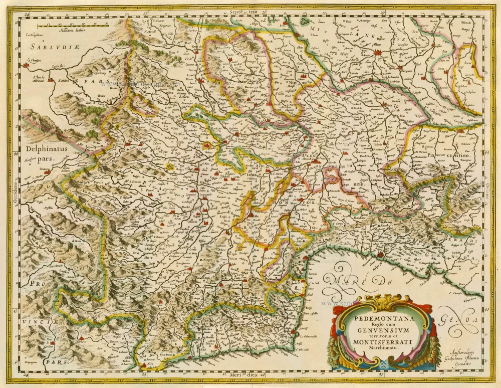
Pedemontana Regio cum Genvensium territorio et Montisferrati Marchionatu. 1635
Piemonte, by W. Blaeu.
[Item number: 20371]

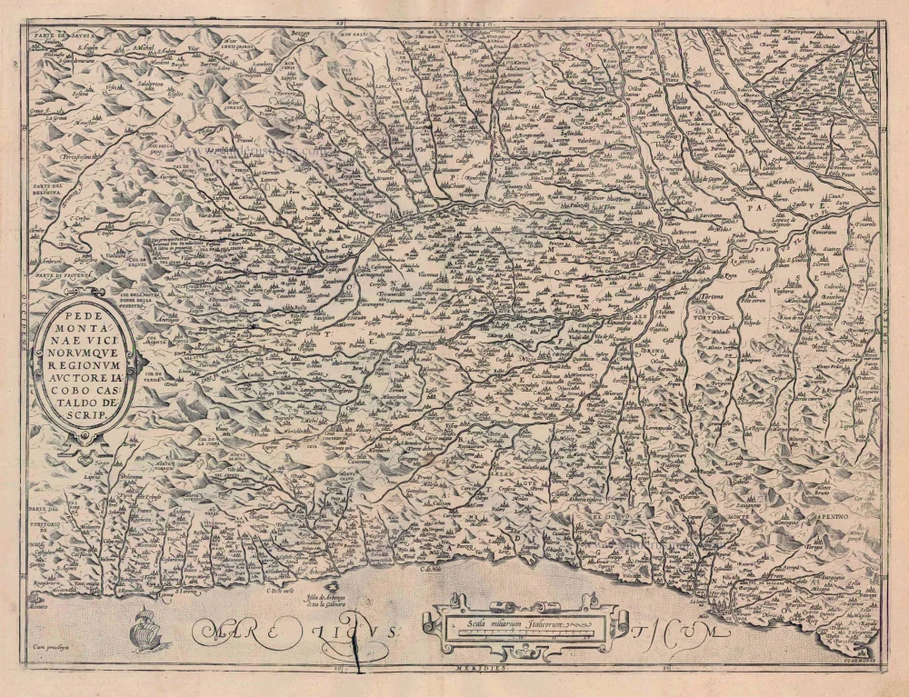
Pedemontanae Vicinorumquae Regionum. 1601
Piemonte, by Abraham Ortelius.
[Item number: 21259]
Piemonte et Monferrato 1644-58
Piemonte - Monferrato, by Janssonius J. - Hondius H.
[Item number: 22847]
Pedemontanae Vicinorumquae Regionum 1612
Piemonte, by Abraham Ortelius.
[Item number: 23019]

Theatre de la Guerre en Savoie et en Piémont - Le Dauphiné, La Bresse - Partie du Lionnois et de la Provence. 1721-41
Piedmont (Piemonte) and Savoy, by Covens & Mortier.
[Item number: 23544]

Levée du Siège de Coni Ville de Piemont Assiégée par les François & Secouru par le Serenissime Prince Eugene de Savoye General des Troupes de l'Empereur en 1691. 1729
The Battle of Cuneo (Piemonte) after Jan van Huchtenburg.
[Item number: 25965]

Le Piemont. 1713
Piedmont (Piemonte), by Pieter Van der Aa.
[Item number: 26093]

Carte qui contient la Principauté de Piémont, Le Montferrat, et la Comté de Nice, avec la rivière de Ponent de Gènes. 1776-79
Piemonte and Montferrat, by Paolo Santini.
[Item number: 27708]

Status Belli Italiam inter et Galliam Comprehendens Sabaudiae Ducatum Pedemontii Princip. et Nicaeensem Comitatum Partemque Delphinatus et Provinciae etc. after 1721
Piemonte & Valle d'Aosta by Frederik de Wit, published by Covens & Mortier.
[Item number: 28324]
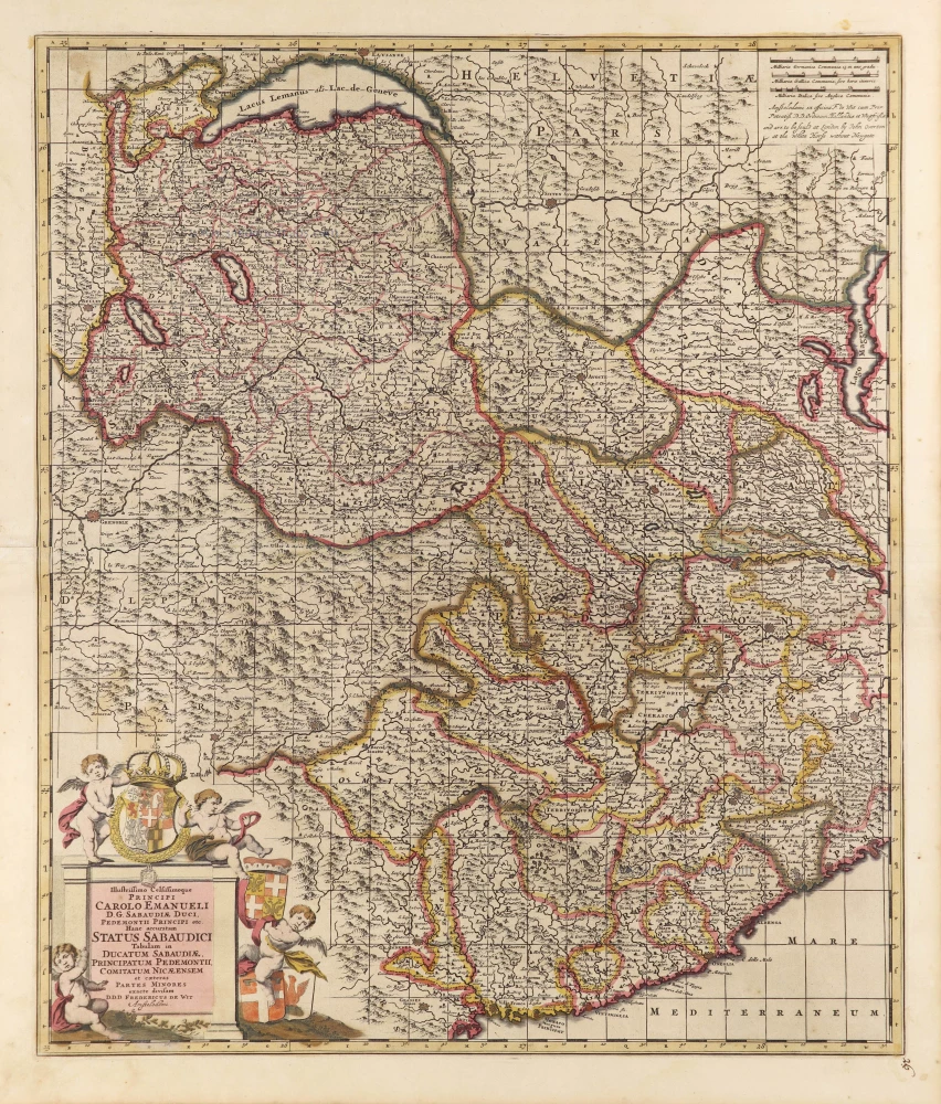
Illustrissimo Celsissimoque Principi Carolo Emanueli D.G. Sabaudiae Duci, Pedemontii Principi etc. Hanc accuratam Status Sabaudici Tabulam in Ducatum Sabaudiae, Principatum Pedemontii, Comitatum Nicaeensem et caeteras Partes Minores exacte divisam. c. 1690
Duchy of Savoie and Piemonte by Frederick de Wit.
[Item number: 28790]
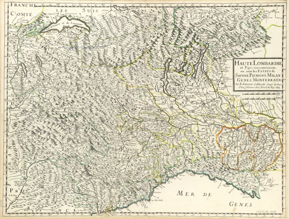
Haute Lombardie et Pays Circomvoisins, ou sont les Estats de Savoye, Piemont, Milan, Genes, Monferrat, &c. 1652
Northwest Italy by Nicolas Sanson.
[Item number: 29719]

Pedemontana Regio, cum Genuensium territorio et Montifferrati Marchionatu. 1607
Piemonte, Liguria, and Monferrato by Gerard Mercator, published by Jodocus Hondius.
[Item number: 31458]
Piemont. 1618
Piemonte by Petrus Bertius, published by Jodocus Hondius II.
[Item number: 31635]

Regiae Celsitudinis Sabaudicae Status in quo Ducatus Sabaudiae Principatus Pedemontium et Ducatus Montisferrati in suas quasq. Ditiones & Territoria divisi cum finitimis Regionibus exhibentur. c. 1720
Piemonte, Liguria, and Monferrato, by J.B. Homann.
[Item number: 32276]