
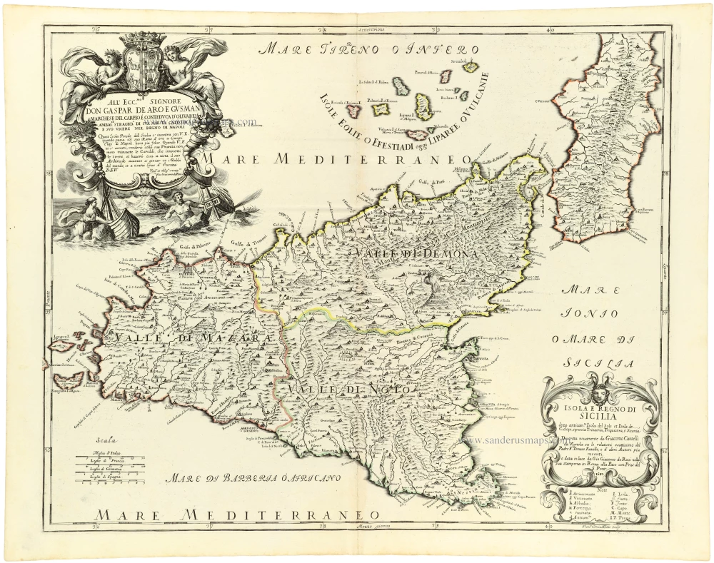
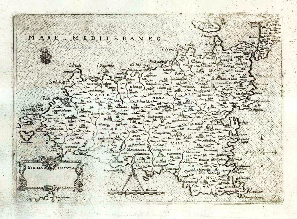
Sicilia, by Giacomo Cantelli da Vignola, published by Giovanni de Rossi. 1684
de Rossi Family
Seventeenth-century Rome was home to the famous publishing house of de Rossi. Two branches of the family used the addresses in Piazza Navona and Piazza della Pace; the latter was the more important house. Giuseppe de Rossi founded the house in 1613 and continued until he died in 1639. Giovanni Giacomo de Rossi flourished from 1649 to 1691. In 1677, he published a folio atlas titled Mercurio Geografico. It was drawn almost entirely from the cartography of the Sanson family in Paris. Whether it was with their permission or simple plagiarism is unknown, but they are credited. (Burden)
Giuseppe Rossi (flourished 1613-1639), Publisher at 'Piazza della Pace'.
Giovanni Giacomo de Rossi (1627-1691), Printer and publisher at 'Alla Pace all'insegna di Parigi', Rome.
Domenico de Rossi (flourished c. 1691-c. 1720), Successor to Giovanni Giacomo Rossi.
Lorenzo Filippo Rossi (flourished c. 1720-1738). Successor to Domenico.
In 1738, the Rossi plates were sold to the government of the Papal States.
Giacomo Cantelli da Vignola (1643-1695)
Italian cartographer and engraver. He was a geographer and court librarian to the Duke of Modena. Later, he moved to Venice, becoming well known as a geographer and cartographer. From 1672, his maps were published by Giovanni Giacomo de Rossi.
Isola e Regno di Sicilia
Item Number: 32915 Authenticity Guarantee
Category: Antique maps > Europe > Italy
Sicilia, by Giacomo Cantelli da Vignola, published by Giovanni de Rossi.
Title: Isola e Regno di Sicilia
detta anticam[en]te Isola del Sole de Ciclopi, è poscia Trinacria, Triquestra, e Sicania
Descritta novamente da Giacomo Catelli da Vignola su le relationi esattissime del Padre F. Tomaso Fazello, e d'altri Autori piu recenti, e data in luce da Gio Giacomo de Rossi nella sua stamperia in Roma alla Pace con Priu' del S. Pont. 1682.
Franc[isc]us Donia Messis. sculp.
Engraver: Francesco Donia.
Date of the first edition: 1682.
Date of this map: 1684.
Date on map: 1682.
Copper engraving, printed on paper.
Image size: 445 x 545mm (17½ x 21½ inches).
Sheet size: 475 x 615mm (18¾ x 24¼ inches).
Verso: Blank.
Condition: Original coloured in outline, excellent.
Condition Rating: A+.
From: Mercurio Geografico overo Guida Geografica in Tutte le Parti di Mondo Conforme le Tavole Geografiche del Sansone Baudrand e Cantelli. Rome, [1684]. (Shirley (Brit. Lib.), T.ROSS-1a)
de Rossi Family
Seventeenth-century Rome was home to the famous publishing house of de Rossi. Two branches of the family used the addresses in Piazza Navona and Piazza della Pace; the latter was the more important house. Giuseppe de Rossi founded the house in 1613 and continued until he died in 1639. Giovanni Giacomo de Rossi flourished from 1649 to 1691. In 1677, he published a folio atlas titled Mercurio Geografico. It was drawn almost entirely from the cartography of the Sanson family in Paris. Whether it was with their permission or simple plagiarism is unknown, but they are credited. (Burden)
Giuseppe Rossi (flourished 1613-1639), Publisher at 'Piazza della Pace'.
Giovanni Giacomo de Rossi (1627-1691), Printer and publisher at 'Alla Pace all'insegna di Parigi', Rome.
Domenico de Rossi (flourished c. 1691-c. 1720), Successor to Giovanni Giacomo Rossi.
Lorenzo Filippo Rossi (flourished c. 1720-1738). Successor to Domenico.
In 1738, the Rossi plates were sold to the government of the Papal States.
Giacomo Cantelli da Vignola (1643-1695)
Italian cartographer and engraver. He was a geographer and court librarian to the Duke of Modena. Later, he moved to Venice, becoming well known as a geographer and cartographer. From 1672, his maps were published by Giovanni Giacomo de Rossi.
Related items
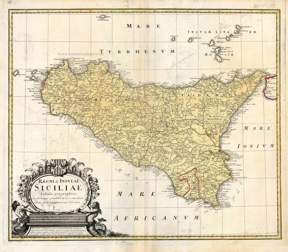
Regni & Insulae Siciliae Tabula Geographica ... c. 1720-65
Sicily, by Homann Heirs.
[Item number: 25478]

Isle et Royaume de Sicile. 1665
Sicily, by N. & G. Sanson.
[Item number: 25896]

In rare original colour.
L'Ile de Sicile. 1713
Sicily, by Pieter Van der Aa.
[Item number: 26077]

La Sicile, Avec les anciens noms de presque toutes ses Places, Rivieres, Chasteaux, &c. 1679
Sicily, by P. Duval.
[Item number: 26485]
Sicilia. 1602
Sicily (Sicilia), by Langenes, published by P. Bertius.
[Item number: 26539]
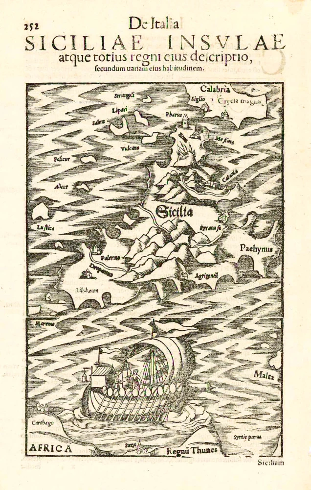
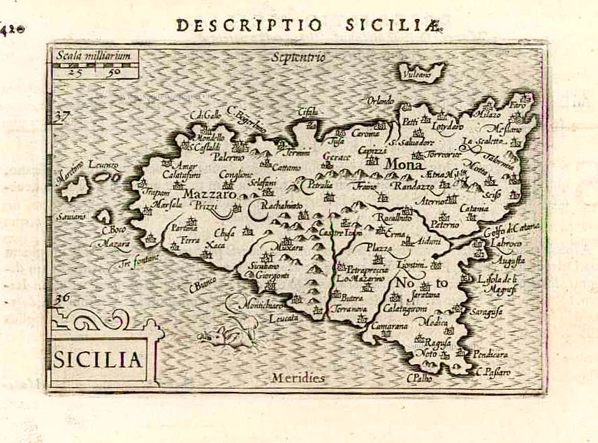
Sicilia. - Siciliae Insulae atque totius regni eius descriptio, ... 1552
Sicily, by Sebastian Münster.
[Item number: 27267]
Sicilia Insula. After 1575
Sicily (Sicilia) by Giovanni Francesco Camocio
[Item number: 27566]

Carte de L'Isle et Royaume de Sicile. 1776-79
Sicily & Malta, by Paolo Santini.
[Item number: 27732]
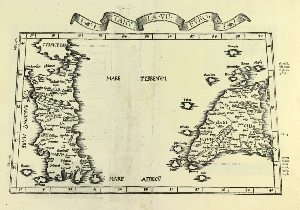
Tabula . VII . Euro. 1525
Sardinia & Sicily by Lorenz Fries.
[Item number: 28385]

Regnum Siciliae cum circumjacentibus Regnis et Insulis. c. 1680
Sicily with the isles of Malta and Gozo, by Nicolaes Visscher I.
[Item number: 28607]

Sicilia Regnum. 1650
Sicily (Sicilia), by Willem & Joan Blaeu.
[Item number: 28774]
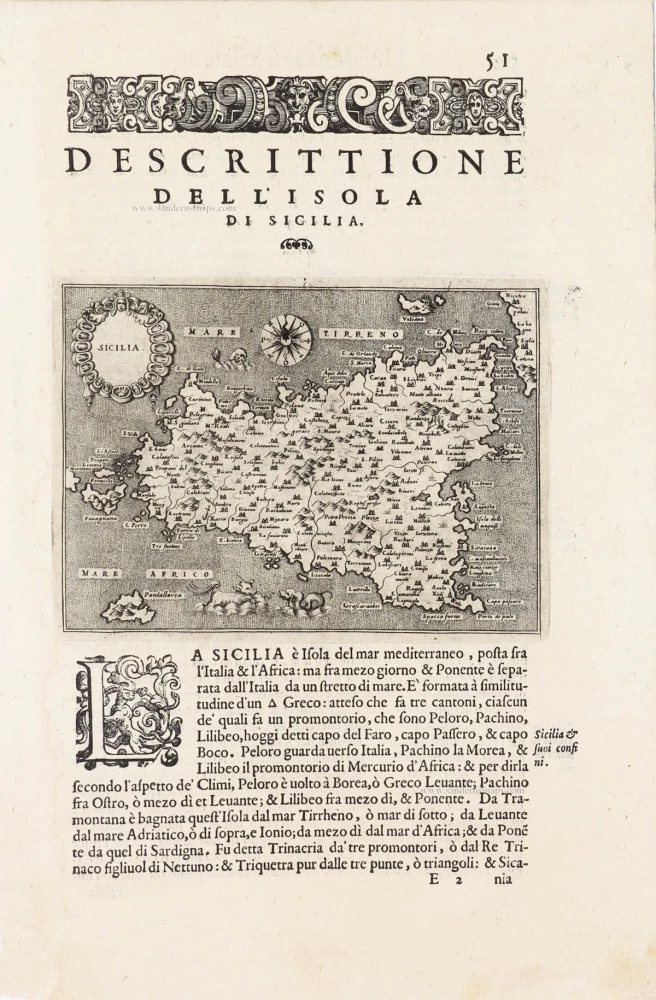
Sicilia - [Above map :] Descrittione dell'Isola di Sicilia. 1590
Sicily (Sicilia) by Thomaso Porcacchi.
[Item number: 29766]

Tabula . VII . Euro. 1525
Ptolemy map of Sardinia & Sicily by Lorenz Fries, after Martin Waldseemüller
[Item number: 30534]

Catana Urbs Siciliae Clarissima Patriae Scte Agathae Virginis et Mart: 1657
Catania with view of the Mount Etna by Georg Braun & Frans Hogenberg, published by J. Janssonius.
[Item number: 31003]

Sicilia. 1618
Sicily (Sicilia) by Petrus Bertius, published by Jodocus Hondius II.
[Item number: 31860]
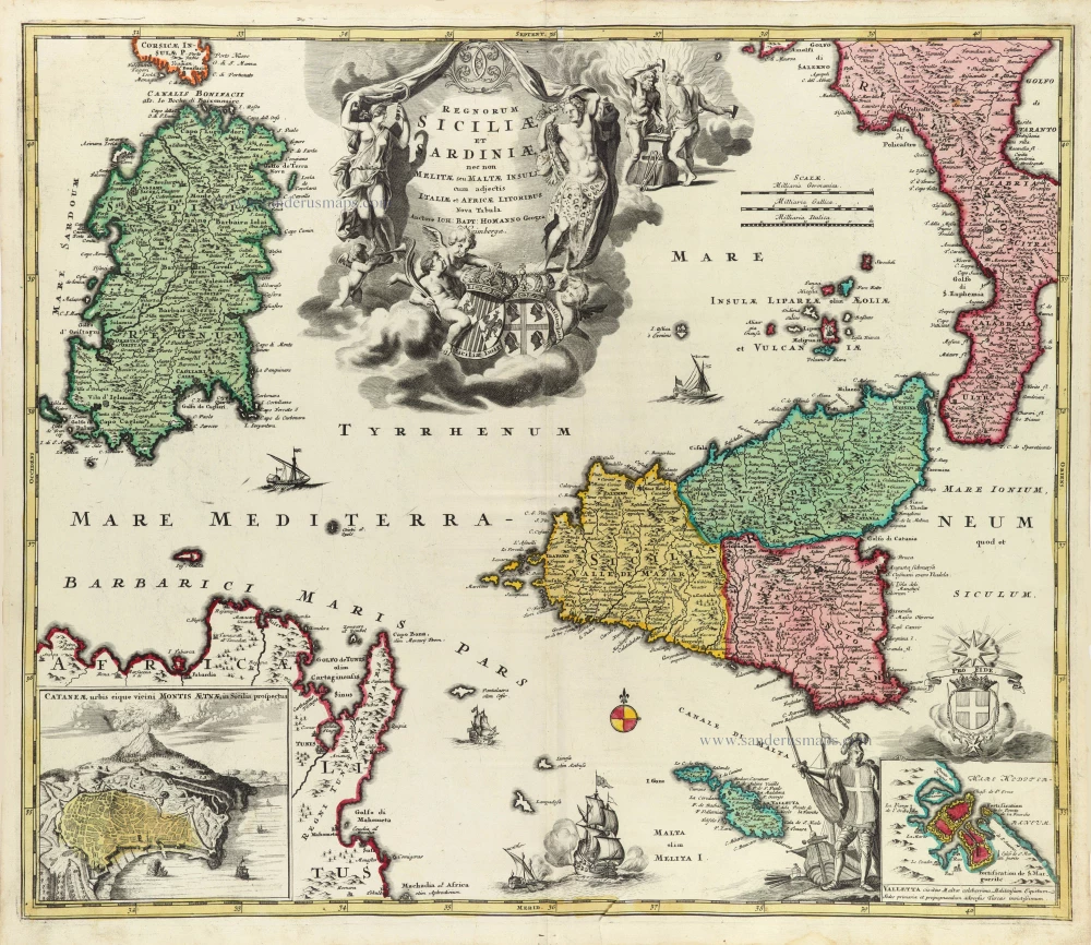
Regnorum Siciliae et Sardiniae nec non Melitae seu Maltae insuli cum adjectis Italiae et Africae Litoribus Nova Tabula. c. 1720
Sicily - Sardinia, by J.B. Homann.
[Item number: 32164]

Tabula Moderna Italie. 1525
Corsica, Sardinia, and Sicilia (Sicily), by Lorenz Fries.
[Item number: 32732]

Parergon map
Siciliae Veteris Typus. 1592
Ancient Sicily, by Abraham Ortelius.
[Item number: 33064]
new

Insula sive Regnum Siciliae Urbibus praecipuis exornatum 1682-88
Sicily by Frederick de Wit.
[Item number: 33168]
new