
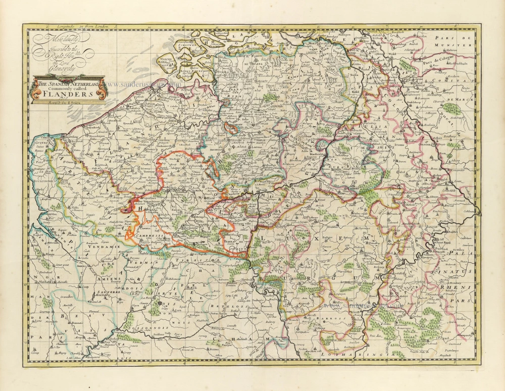
Spanish Netherlands (= Belgium) by John Senex. 1721

John Senex (c. 1678 - 1740)
John Senex was an engraver and map seller, later cultivating his scientific interests as a maker of instruments and globes. He apprenticed to London bookseller Robert Clavell in 1695. By 1702, he had set up in business by himself. From about 1706 to 1711, he was in association with the London publisher Charles Price, and together they produced sets of large-sized maps. The partnership between Senex and Price split up in 1710, with Senex being joined by John Maxwell and Price collaborating with George Willdey. Later collections of the double-folio maps carry the imprint of Senex and Maxwell, culminating in their joint English Atlas of 1714.
As well as compiling general atlases, Senex produced a popular book of strip road maps based on Ogilby and engraved the maps used in several editions of Patrick Gordon's Geography Anatomiz'd. Senex also contributed to the Atlas Maritimus.
The Spanish Netherlands Commonly called Flanders.
Item Number: 30521 Authenticity Guarantee
Category: Antique maps > Europe > Belgium
Spanish Netherlands (= Belgium) by John Senex.
Title: The Spanish Netherlands Commonly called Flanders.
1719.
Revised by I. Senex.
Most humbly Inscribed to the Right Hon.ble the Lord Glenorchy.
Date of the first edition: 1719.
Date of this map: 1721.
Date on map: 1719.
Copper engraving, printed on paper.
Image size: 400 x 540mm (15.75 x 21.26 inches).
Sheet size: 535 x 600mm (21.06 x 23.62 inches).
Verso: Blank.
Condition: Original coloured in outline.
Condition Rating: A+.
From: Senex John, A New General Atlas, Containing a Geographical and Historical Account Of All the Empires, Kingdoms, and other Dominions of the World ... London, ... M.DCC.XXI. [1721] ( Shirley, Brit. Lib. I, p. 942, T.SEN-2a)
John Senex (c. 1678 - 1740)
John Senex was an engraver and map seller, later cultivating his scientific interests as a maker of instruments and globes. He apprenticed to London bookseller Robert Clavell in 1695. By 1702, he had set up in business by himself. From about 1706 to 1711, he was in association with the London publisher Charles Price, and together they produced sets of large-sized maps. The partnership between Senex and Price split up in 1710, with Senex being joined by John Maxwell and Price collaborating with George Willdey. Later collections of the double-folio maps carry the imprint of Senex and Maxwell, culminating in their joint English Atlas of 1714.
As well as compiling general atlases, Senex produced a popular book of strip road maps based on Ogilby and engraved the maps used in several editions of Patrick Gordon's Geography Anatomiz'd. Senex also contributed to the Atlas Maritimus.
Related items
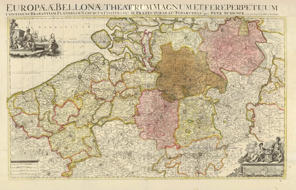
Europae (Ae) Bellonae Theatrum Magnum et Fere Perpetuum continens Brabantiam, Flandriam, Namurcum finitimasque Praefecturas ac Toparchias. c. 1730-1760
Southern Netherlands, by Petrus Schenk.
[Item number: 28008]
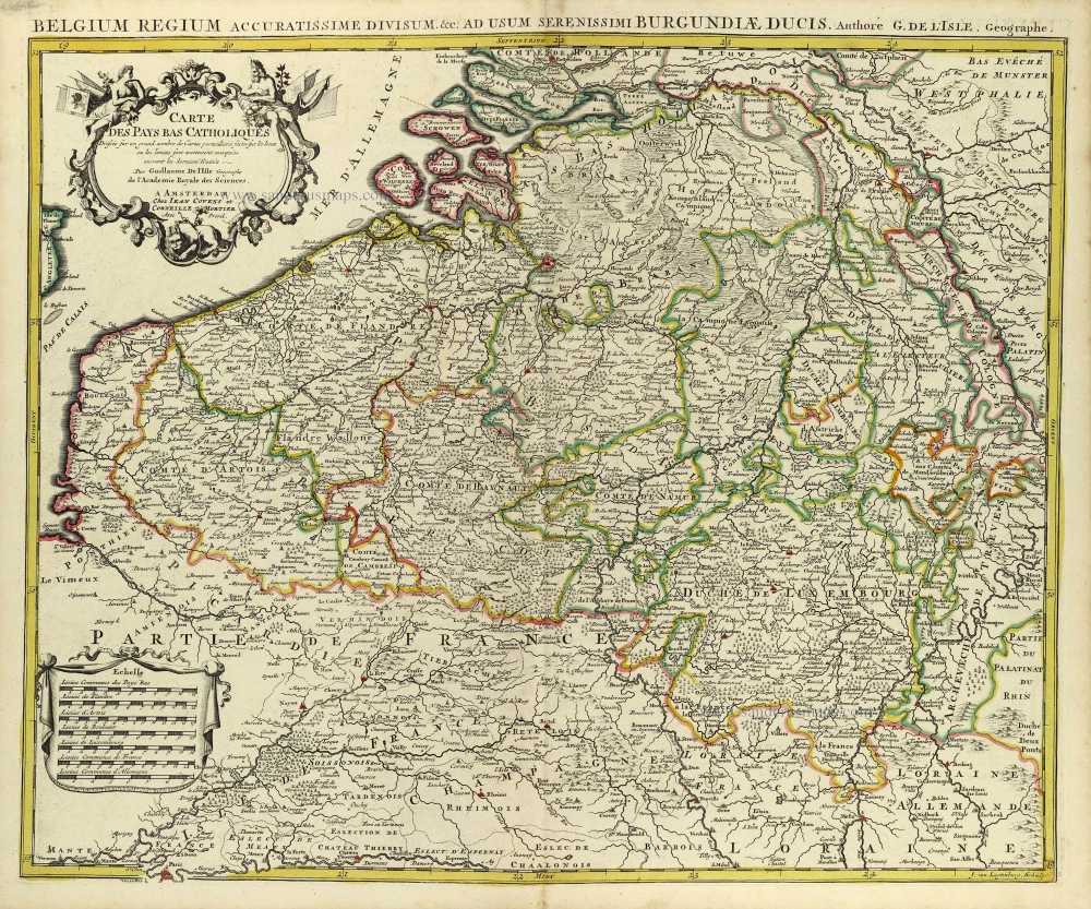
Carte des Pays Bas Catholiques. [Title above map:] Belgium Regium Accuratissime divisum. &c. ad usum serenissimi Burgundiae Ducis. Aythore G. De L'Isle, Geographe. ca. 1730.
Southern Netherlands by G. De L'Isle, published by Covens & Mortier.
[Item number: 28338]
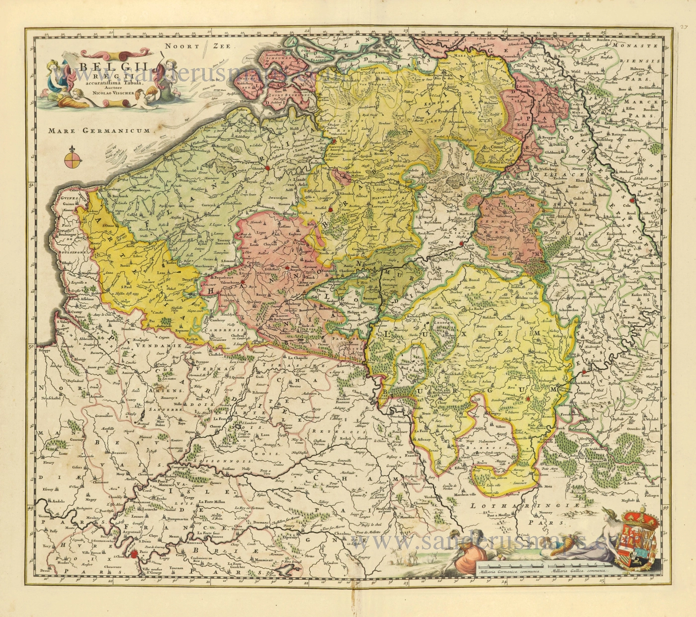
Belgii Regii accuratissima Tabula. c. 1678
Southern Netherlands (Zuidelijke Nederlanden) by Nicolaes Visscher I.
[Item number: 28518]
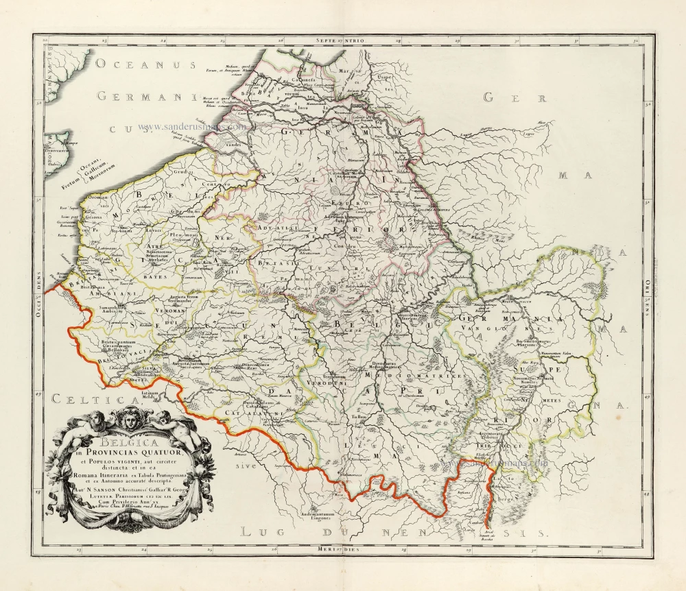
Belgica in Provincias Quatuor, et Populos viginti, aut circiter distincta: et in ea Romana Iteneraria ex Tabula Peutingeriana et ex Antonino accuratè descripta. 1676
Ancient Belgium by Nicolas Sanson.
[Item number: 30032]
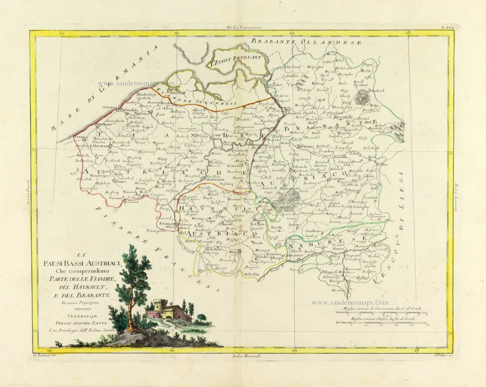
Li Paesi Bassi Austriaci, che comprendono Parte delle Fiandre, del Haynault, e del Brabante. 1779-1785
Austrian Netherlands, by Antonio Zatta.
[Item number: 31811]