
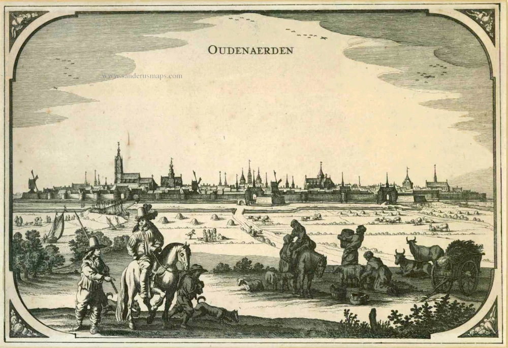
The vicinity of Oudenaarde, by Pieter Husson. c. 1709

Broadsheet on the Battle of Oudenaarde in 1708, consisting of a single sheet printed with an etched plate and letterpress below: the etched plate with a ground plan of the battle and a vignette of the fight itself in the lower right; below in letterpress an account in four columns, in French and Dutch.
Pierre Husson (1678-1733)
Pierre (Pieter), a publisher in Den Haag, was a neighbour of Mrs Anna Beek, with whom he shared his interest in publishing plans of battlefields and fortifications during the War of Succession (1702-1713).
A collection of maps and plans by various authors was brought together in an atlas, to which was added the title page of Nicolas Visscher's Variae tabulae geographicae in quibus loca in orbe bello, now with the address of Pierre Husson.
Plan du Champ de Bataille, prés d'Oudenaerde l'11. Juillet 1708. - Plaen van de Bataille, by Oudenaerde, den 11 July 1708.
Item Number: 27525 Authenticity Guarantee
Category: Antique maps > Europe > Belgium
Old, antique map of The vicinity of Oudenaarde, by Pieter Husson.
Title: Plan du Champ de Bataille, prés d'Oudenaerde l'11. Juillet 1708. - Plaen van de Bataille, by Oudenaerde, den 11 July 1708.
G. Schouten F.
In 's Gravenhage, by Pieter Husson, Boekverkoper, 1708.
Oriented to the northwest.
Engraver: G. Schouten.
Date of the first edition: 1708.
Date of this map: c. 1709.
Copper engraving, printed on paper.
Size (not including margins): 380 x 495mm (14.96 x 19.49 inches).
Verso: Blank.
Condition: Original-coloured, age-toned.
Condition Rating: A.
From: Variae tabulae geographicae un quibus loca in orbe bello flagrantia conspiciuntur ut in Flandria, Brabantia, Leodiensi Tractu, Germania, Hungaria, . . . Diverses cartes de geographie, où l'on peut voir le theatre de la guerre dans tout le monde. Comme dans les pais de Flandres, de Brabant, de Liège, d'Allemagne, de Hongrie, . . . Den Haag, P. Husson, s.d. (c. 1709). (Koeman II, p. 155, Hus1)
Broadsheet on the Battle of Oudenaarde in 1708, consisting of a single sheet printed with an etched plate and letterpress below: the etched plate with a ground plan of the battle and a vignette of the fight itself in the lower right; below in letterpress an account in four columns, in French and Dutch.
Pierre Husson (1678-1733)
Pierre (Pieter), a publisher in Den Haag, was a neighbour of Mrs Anna Beek, with whom he shared his interest in publishing plans of battlefields and fortifications during the War of Succession (1702-1713).
A collection of maps and plans by various authors was brought together in an atlas, to which was added the title page of Nicolas Visscher's Variae tabulae geographicae in quibus loca in orbe bello, now with the address of Pierre Husson.
Related items

Audenaerde. 1659
Oudenaarde, by Matthäus Merian & Martin Zeiller.
[Item number: 2239]

Audenarde. 1726
Oudenaarde by Fassmann
[Item number: 5958]
Oudenaerden. 1656
Oudenaarde, by N. Visscher & P.H. Schut.
[Item number: 6998]

Glorieuse Batalye by Oudenaarden voorgevalletussen de Geallieerde en Franse Legers op den 11 Juli 1708. 1708
Military plan of Oudenaarde
[Item number: 25304]

Castellum de Pamele. 1652
Oudenaarde - Pamele Castle, by Joan Blaeu.
[Item number: 25576]

Spectacular view of the Siege.
Veuë de la Ville et du Siege d'Oudenarde, ou le Roy commande en personne, en lannée 1667. - Aldenardae a Rege obsessae prospectus, anno 1667. 1685
Oudenaarde by Frans Vander Meulen
[Item number: 25797]

Plan de la Bataille d'Oudenaerde du 11 Juillet 1708. 1712
Oudenaarde by Eugène Fricx.
[Item number: 29585]

Oudenarde. - Carte du Gouvernement d'Oudenarde. - Plan de la Ville d'Oudenarde. ca. 1668
Oudenaarde by Sr. S. de Beaulieu - three plates.
[Item number: 30300]

Castellania Aldenardensis. 1732
Casselrij Oudenaarde by Antonius Sanderus.
[Item number: 30766]

Aldenarda vulgo Audenaerde. 1732
Panoramic view and plan of Oudenaarde by Antonius Sanderus.
[Item number: 30767]

Rare Dutch text edition
Aldenarda vulgo Audenaerde. 1652
Oudenaarde by Joan Blaeu.
[Item number: 30810]

Aldenarda vulgo Audenaerde. 1652
Oudenaarde by Antonius Sanderus, published by Joan Blaeu.
[Item number: 31179]

Eglise de Pamele à Audenarde. 1823
Oudenaarde - Pamele, lithograph by Dewasme, after Séraphin Vermote.
[Item number: 32808]

Hôtel de ville d'Audenarde. 1823
Oudenaarde, lithograph by Dewasme, after Séraphin Vermote
[Item number: 33143]