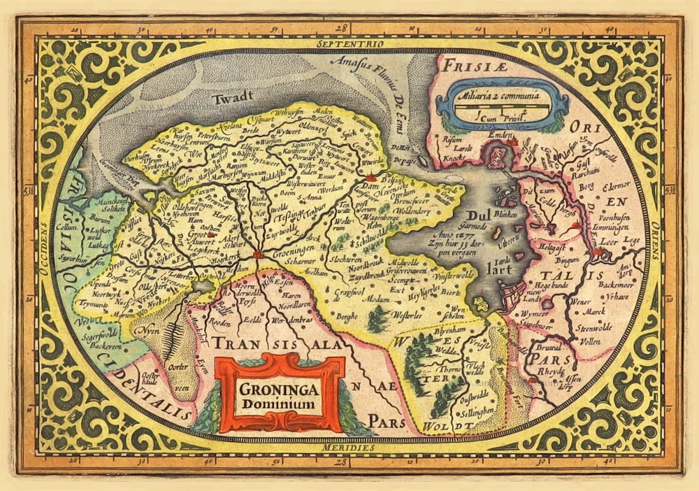
Friesland and Groningen, by Petrus Kaerius (Pieter Van den Keere). 1617
This map was engraved initially by Joannes van Doetecum and published by Cornelis Claesz, ca. 1600. After the death of Cornelis Claesz, the copperplate came into the possession of Pieter van den Keere who reworked this plate to include it into his atlas Germania Inferior. The copperplate was shortened by about 3.5 cm at the bottom, while an even wider strip of 7.5 cm was cut off the right edge. As a result, part of Gelderland and Twente disappeared from the map image in the south and part of Eastern Friesland in the east. Due to this rigorous cut-back, the original title of the map was lost mainly; what was left of it was then polished away.
Pieter Van den Keere (Petrus Kaerius) (1571-c.1650)
Pieter van den Keere was born in Ghent in 1571 as the son of the type-founder, Hendrik van den Keere. In 1584, he moved with his family to London for religious reasons. There, Van den Keere received training as an engraver from Jodocus Hondius, his brother-in-law. Not only the companionship with Jodocus Hondius but also the acquaintanceship with Pieter van den Berghe (Petrus Montanus), author of the text of the Germania Inferior, originates from the years of refuge in London.
Upon their settlement in Amsterdam in 1593, both Keere and Hondius embarked on a monumental project. Their collaboration resulted in the creation of a large wall map of Europe, a masterpiece that still stands as a testament to their skill and vision, dated 1595: Nova totius Europae descriptio.
In 1610, he set up a workshop in the Kalverstraat that he called ‘In den onseeckeren tijd’ (In the uncertain time). During this period, he made numerous copperplates, including maps for his Atlas of the Netherlands and the Atlas Minor published by Jodocus Hondius.
The Germania Inferior (1617) is the first original atlas of the Netherlands published in folio size. The text for the atlas, both in Dutch and in French, was written by Petrus Montanus. After 1623, Claes Jansz. Visscher bought the plates and substituted his name for Kaerius’s. In 1634, Visscher included many of these maps in his Germana Inferior.
Kaerius's fame is not only based on his atlas of the Netherlands. He is even better known as an engraver of many loose-leaf maps and as a collaborator of book publishers. His maps are found, i.e., in the Caert thresoor (Barent Langenes, 1598), Licht der Zeevaert (Blaeu, 1608), Atlas Minor (Hondius, 1628), and Caertboeck vande Midellandsche Zee (Barents, 1595).
Nieuwe beschrijvinge van Oost en West Vrieslant door Davidt Fabricio van Esentz soe wel voor water als te lande neerstelyck beschreven. - Nova descriptio orientalis et occidentalis frisiae, cum vicinis mari terra que limitibus per davidem fabricium esensem accurate expreßa.
Item Number: 29128 Authenticity Guarantee
Category: Antique maps > Europe > The Netherlands
Old, antique map of Friesland and Groningen, by Petrus Kaerius (Pieter Van den Keere).
Title: Nieuwe beschrijvinge van Oost en West Vrieslant door Davidt Fabricio van Esentz soe wel voor water als te lande neerstelyck beschreven. - Nova descriptio orientalis et occidentalis frisiae, cum vicinis mari terra que limitibus per davidem fabricium esensem accurate expreßa.
Petrus Kaerius exc. Anno 1617.
Cartographer: David Fabricius.
Engraver: Joannes Van Doetecum / Pieter Van den Keere.
Date of the first edition: 1617.
Date of this map: 1617.
Date on map: 1617.
Copper engraving, printed on paper.
Map size: 375 x 485mm (14.76 x 19.09 inches).
Sheet size: 410 x 535mm (16.14 x 21.06 inches).
Verso: Latin text.
Condition: Hand coloured, centrefold reinforced, some creasing along centrefold.
Condition Rating: A
From: Petri Kaerii Germania Inferior id est, XVII provinciarum ejus novae et exactae Tabulae Geographicae, cum Luculentis Singularum descriptionibus additis. À Petro Montano. Amsterdam, 1617. (Koeman, Kee1; Van der Krogt 3, 64:01)
This map was engraved initially by Joannes van Doetecum and published by Cornelis Claesz, ca. 1600. After the death of Cornelis Claesz, the copperplate came into the possession of Pieter van den Keere who reworked this plate to include it into his atlas Germania Inferior. The copperplate was shortened by about 3.5 cm at the bottom, while an even wider strip of 7.5 cm was cut off the right edge. As a result, part of Gelderland and Twente disappeared from the map image in the south and part of Eastern Friesland in the east. Due to this rigorous cut-back, the original title of the map was lost mainly; what was left of it was then polished away.
Pieter Van den Keere (Petrus Kaerius) (1571-c.1650)
Pieter van den Keere was born in Ghent in 1571 as the son of the type-founder, Hendrik van den Keere. In 1584, he moved with his family to London for religious reasons. There, Van den Keere received training as an engraver from Jodocus Hondius, his brother-in-law. Not only the companionship with Jodocus Hondius but also the acquaintanceship with Pieter van den Berghe (Petrus Montanus), author of the text of the Germania Inferior, originates from the years of refuge in London.
Upon their settlement in Amsterdam in 1593, both Keere and Hondius embarked on a monumental project. Their collaboration resulted in the creation of a large wall map of Europe, a masterpiece that still stands as a testament to their skill and vision, dated 1595: Nova totius Europae descriptio.
In 1610, he set up a workshop in the Kalverstraat that he called ‘In den onseeckeren tijd’ (In the uncertain time). During this period, he made numerous copperplates, including maps for his Atlas of the Netherlands and the Atlas Minor published by Jodocus Hondius.
The Germania Inferior (1617) is the first original atlas of the Netherlands published in folio size. The text for the atlas, both in Dutch and in French, was written by Petrus Montanus. After 1623, Claes Jansz. Visscher bought the plates and substituted his name for Kaerius’s. In 1634, Visscher included many of these maps in his Germana Inferior.
Kaerius's fame is not only based on his atlas of the Netherlands. He is even better known as an engraver of many loose-leaf maps and as a collaborator of book publishers. His maps are found, i.e., in the Caert thresoor (Barent Langenes, 1598), Licht der Zeevaert (Blaeu, 1608), Atlas Minor (Hondius, 1628), and Caertboeck vande Midellandsche Zee (Barents, 1595).