
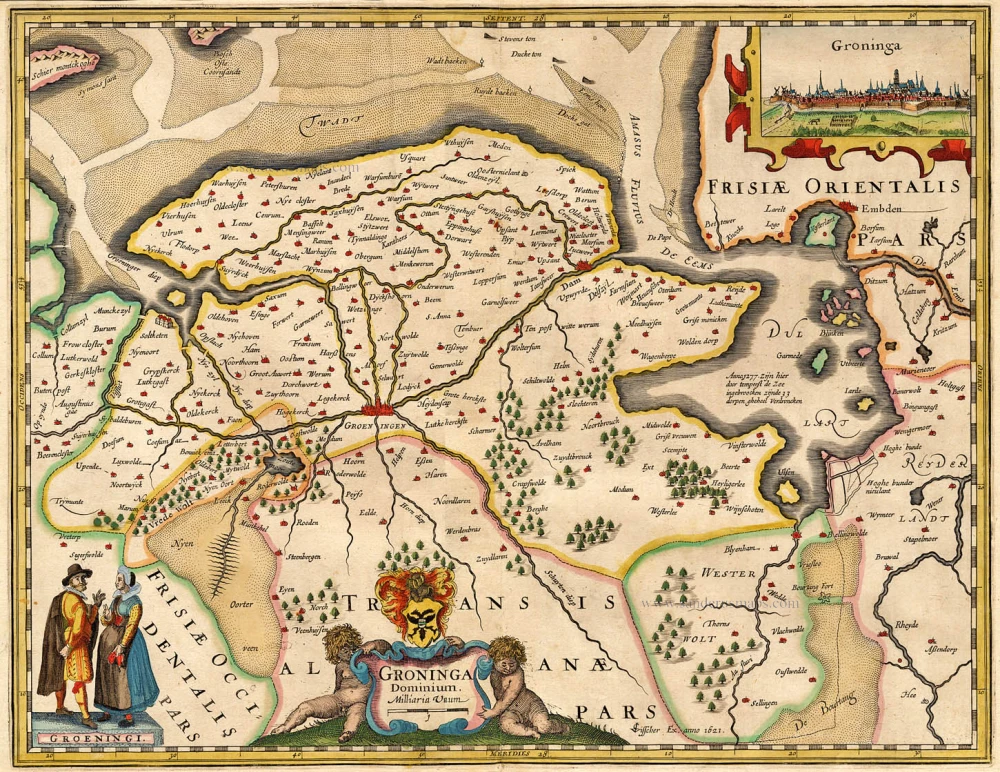
Groningen by G. Mercator / J. Hondius, published by J. Janssonius. 1631

The Janssonius Family
Joannes Janssonius (Arnhem, 1588-1664), son of the Arnhem publisher Jan Janssen, married Elisabeth Hondius, daughter of Jodocus Hondius, in Amsterdam in 1612. After his marriage, he settled down in this town as a bookseller and publisher of cartographic material. In 1618 he established himself in Amsterdam next door to Blaeu’s book shop. He entered into serious competition with Willem Jansz. Blaeu when copying Blaeu’s Licht der Zeevaert after the expiration of the privilege in 1620. His activities not only concerned the publication of atlases and books, but also of single maps and an extensive book trade with branches in Frankfurt, Danzig, Stockholm, Copenhagen, Berlin, Koningsbergen, Geneva, and Lyon. In 1631 he began publishing atlases together with Henricus Hondius.
In the early 1640s Henricus Hondius left the atlas publishing business completely to Janssonius. Competition with Joan Blaeu, Willem’s son and successor, in atlas production prompted Janssonius to enlarge his Atlas Novus finally into a work of six volumes, into which a sea atlas and an atlas of the Old World were inserted. Other atlases published by Janssonius are Mercator’s Atlas Minor, Hornius’s historical atlas (1652), the townbooks in eight volumes (1657), Cellarius’s Atlas Coelestis and several sea atlases and pilot guides.
After the death of Joannes Janssonius, the shop and publishing firm were continued by the heirs under the direction of Johannes van Waesbergen (c. 1616-1681), son-in-law of Joannes Janssonius. Van Waesbergen added the name of Janssonius to his own.
In 1676, Joannes Janssonius’s heirs sold by auction “all the remaining Atlases in Latin, French, High and Low German, as well as the Stedeboecken in Latin, in 8 volumes, bound and unbound, maps, plates belonging to the Atlas and Stedeboecken.” The copperplates from Janssonius’s atlases were afterwards sold to Schenk and Valck.
Gerard Mercator (1512 – 1594)
Gerard Mercator was born Gerard de Cremere in Rupelmonde (near Antwerp) on 5 March 1512.
Young Gerard learned what Latin he could in Rupelmonde, and when he was about fifteen, his uncle sent him to s'Hertogenbosch to study at a school run by the Brothers of the Common Life. One of Mercator’s teachers was the celebrated humanist Macropedius. After three and a half years with the brothers, Gerard went to Louvain, where he enrolled in the university in 1530 as one of the poor students at Castle College.
By this time, he had Latinized his name to Mercator. He studied philosophy and took his master’s degree in 1532. The problems of the creation of the Universe and the Earth interested him in particular, and this is reflected in his works written in later years.
After spending a few years in Antwerp, he returned to Louvain in c. 1535, where he took courses in mathematics under Gemma Frisius. Soon, he was recognised as an expert on the construction of mathematical instruments, as a land surveyor and, after 1537, as a cartographer. He drew his income from these activities after his marriage on August 3, 1536. He also qualified himself as a copper engraver, the first to introduce italic handwriting to this trade. The first maps, drawn and engraved by Gerard Mercator, are Palestine, 1537; the World in double heart-shaped projection, 1538; and Flanders, 1540.
In 1544, Mercator came into great danger: he was arrested on the accusation of heresy and put into jail. Thanks to the intervention of the University of Louvain, he was released after four months. In 1552, he moved with his family to Duisburg (Germany). In 1560, Mercator became a cosmographer in service of the Duke of Jülich-Cleve-Berge, and in 1563, he became a lecturer at the Grammar School of the new University in Duisburg. During this period, he made wall maps of Europe, 1554; of Loraine, 1564; the British Isles, 1564; and the famous world map with increasing latitudes, 1569. About this time, Mercator was also working on the project for a complete description of the creation, the Heavens, Earth, Sea and world history. This resulted in his Atlas, sive cosmographicae meditationes de fabrica mundi et fabricati figura. He also worked on an edition of Ptolemy’s Geographia in 1578. The first part of his book, which contains modern maps (France, Germany, and the Netherlands), appeared in 1585.
Shortly after the publication of the second part of his map book (not yet called Atlas) with the maps of Italy (1589), he had a stroke that ended his highly significant productivity. The great man passed away on 2 December 1594, leaving the responsibility of finishing the map book to his son Rumold. The final part of it appeared in 1595. Its title is Pars Altera, and it constitutes an essential part of what was then called Mercator’s Atlas.
The map of Europe and the world map in the Atlas are by Rumold Mercator. After Rumold died in 1599, the Atlas was reissued in 1602.
The plates of the maps, both of the Ptolemy edition and the Atlas, were sold in 1604 to Jodocus Hondius of Amsterdam. The following year, Hondius managed to bring out Ptolemy’s Geographia. In 1606, the first Amsterdam edition of the Mercator Atlas appeared in the next year. From then to 1638, the Atlas saw many enlarged editions in various languages.
The Hondius Family
Jodocus Hondius the Elder (1563-1612)
Joost d’Hondt was born at Wakken (Flanders) in 1563. Two years later, his family settled down in Ghent, where young Joost displayed a great gift for drawing and calligraphy. By study and lessons, he developed his talents and became an engraver with a good reputation.
Due to the circumstances of war, he moved in 1584 to London where he settled down as an engraver, instrument-maker and map-maker. In 1587, he married Coletta van den Keere, sister of the well-known engraver, Pieter van den Keere (Petrus Kaerius); some years earlier his sister, Jacomina, had married Pieter van den Berghe (Petrus Montanus). Joost, who had Latinized his name to Jodocus Hondius, closely co-operated with his two brothers-in-law.
The political situation in the Northern Netherlands in 1593 was such that Jodocus seemed to be justified in establishing himself in Amsterdam, where so many Antwerp printers, publishers, and engravers had gone. In this new centre of cartography, Jodocus Hondius set up his business “In de Wackere Hondt” (in the vigilant dog), this name being an allusion to his birthplace and name. Here he engraved many maps and published atlases and many other works such as his continuation of Gerard Mercator’s Atlas.
He suddenly passed away in February 1612. The publishing firm of Jodocus Hondius was continued by his widow; later on by his two sons Jodocus Jr., and Henricus, and by his son-in-law, J. Janssonius.
Jodocus Hondius II (1594-1629) & Henricus Hondius (1597-1651)
After the father’s death, the widow with her seven children continued publishing the atlases under the name of Jodocus Hondius till 1620. The firm was reinforced by the very welcome help of Joannes Janssonius (1588-1664), who married 24-year-old Elisabeth Hondius in 1612. After 1619 Mercator’s Atlas was published under the name of Henricus Hondius.
One of the most dramatic events in the early history of commercial cartography in Amsterdam was the sale of Jodocus Hondius Jr.’s copper-plates to Willem Jansz. Blaeu in 1629, the year of his death. At least 34 plates, from which Jodocus II had printed single-sheet maps for his own benefit, passed into the hands of his great competitor. Immediately after that, his brother, Henricus, and Joannes Janssonius ordered the engraving of identical plates.
During a long period, Henricus devoted all his energy to the publication of the Atlas. He saw its growth up to, and including, the fourth part in 1646; after that, his name does not figure any more on the title-pages. After 1638, the title of the Atlas was changed to Atlas Novus; it was mainly carried on by Joannes Janssonius.
The competition with the Blaeus dates from 1630. In 1630, Willem Janszoon (=Blaeu) made the first attack with his Atlantis Appendix. In 1635, Blaeu completed his Theatrum orbis terrarum in two volumes with texts in French, Latin, Dutch, and German, which prompted Henricus Hondius to speed up the enlargement of his Atlas.
Groninga Dominium.
Item Number: 17721 Authenticity Guarantee
Category: Antique maps > Europe > The Netherlands
Old, antique map of Groningen by G. Mercator / J. Hondius, published by J. Janssonius.
Title: Groninga Dominium.
Cartographer: G. Mercator.
Date of the first edition: 1616.
Date of this map: 1631.
Copper engraving, printed on paper.
Image size: 120 x 175mm (4.72 x 6.89 inches).
Sheet size: 185 x 220mm (7.28 x 8.66 inches).
Verso: German text.
Condition: Coloured, excellent.
Condition Rating: A+.
From: Atlas Minor Das ist: Ein kurtze, jedoch gründliche Beschreibung der gantzen Welt, und aller ihrer Theyl, Erstlich von Gerardo Mercatore in Latein beschrieben: Folgends durch Iodocum Hondium mit vielen Kupffern gebessert und vermehrt: und endlich un unsere hochdeutsche Sprach versetzt. Amsterodami, Ex officina Ioannis Ianssonii. MDCXXXI. [1631]
The Janssonius Family
Joannes Janssonius (Arnhem, 1588-1664), son of the Arnhem publisher Jan Janssen, married Elisabeth Hondius, daughter of Jodocus Hondius, in Amsterdam in 1612. After his marriage, he settled down in this town as a bookseller and publisher of cartographic material. In 1618 he established himself in Amsterdam next door to Blaeu’s book shop. He entered into serious competition with Willem Jansz. Blaeu when copying Blaeu’s Licht der Zeevaert after the expiration of the privilege in 1620. His activities not only concerned the publication of atlases and books, but also of single maps and an extensive book trade with branches in Frankfurt, Danzig, Stockholm, Copenhagen, Berlin, Koningsbergen, Geneva, and Lyon. In 1631 he began publishing atlases together with Henricus Hondius.
In the early 1640s Henricus Hondius left the atlas publishing business completely to Janssonius. Competition with Joan Blaeu, Willem’s son and successor, in atlas production prompted Janssonius to enlarge his Atlas Novus finally into a work of six volumes, into which a sea atlas and an atlas of the Old World were inserted. Other atlases published by Janssonius are Mercator’s Atlas Minor, Hornius’s historical atlas (1652), the townbooks in eight volumes (1657), Cellarius’s Atlas Coelestis and several sea atlases and pilot guides.
After the death of Joannes Janssonius, the shop and publishing firm were continued by the heirs under the direction of Johannes van Waesbergen (c. 1616-1681), son-in-law of Joannes Janssonius. Van Waesbergen added the name of Janssonius to his own.
In 1676, Joannes Janssonius’s heirs sold by auction “all the remaining Atlases in Latin, French, High and Low German, as well as the Stedeboecken in Latin, in 8 volumes, bound and unbound, maps, plates belonging to the Atlas and Stedeboecken.” The copperplates from Janssonius’s atlases were afterwards sold to Schenk and Valck.
Gerard Mercator (1512 – 1594)
Gerard Mercator was born Gerard de Cremere in Rupelmonde (near Antwerp) on 5 March 1512.
Young Gerard learned what Latin he could in Rupelmonde, and when he was about fifteen, his uncle sent him to s'Hertogenbosch to study at a school run by the Brothers of the Common Life. One of Mercator’s teachers was the celebrated humanist Macropedius. After three and a half years with the brothers, Gerard went to Louvain, where he enrolled in the university in 1530 as one of the poor students at Castle College.
By this time, he had Latinized his name to Mercator. He studied philosophy and took his master’s degree in 1532. The problems of the creation of the Universe and the Earth interested him in particular, and this is reflected in his works written in later years.
After spending a few years in Antwerp, he returned to Louvain in c. 1535, where he took courses in mathematics under Gemma Frisius. Soon, he was recognised as an expert on the construction of mathematical instruments, as a land surveyor and, after 1537, as a cartographer. He drew his income from these activities after his marriage on August 3, 1536. He also qualified himself as a copper engraver, the first to introduce italic handwriting to this trade. The first maps, drawn and engraved by Gerard Mercator, are Palestine, 1537; the World in double heart-shaped projection, 1538; and Flanders, 1540.
In 1544, Mercator came into great danger: he was arrested on the accusation of heresy and put into jail. Thanks to the intervention of the University of Louvain, he was released after four months. In 1552, he moved with his family to Duisburg (Germany). In 1560, Mercator became a cosmographer in service of the Duke of Jülich-Cleve-Berge, and in 1563, he became a lecturer at the Grammar School of the new University in Duisburg. During this period, he made wall maps of Europe, 1554; of Loraine, 1564; the British Isles, 1564; and the famous world map with increasing latitudes, 1569. About this time, Mercator was also working on the project for a complete description of the creation, the Heavens, Earth, Sea and world history. This resulted in his Atlas, sive cosmographicae meditationes de fabrica mundi et fabricati figura. He also worked on an edition of Ptolemy’s Geographia in 1578. The first part of his book, which contains modern maps (France, Germany, and the Netherlands), appeared in 1585.
Shortly after the publication of the second part of his map book (not yet called Atlas) with the maps of Italy (1589), he had a stroke that ended his highly significant productivity. The great man passed away on 2 December 1594, leaving the responsibility of finishing the map book to his son Rumold. The final part of it appeared in 1595. Its title is Pars Altera, and it constitutes an essential part of what was then called Mercator’s Atlas.
The map of Europe and the world map in the Atlas are by Rumold Mercator. After Rumold died in 1599, the Atlas was reissued in 1602.
The plates of the maps, both of the Ptolemy edition and the Atlas, were sold in 1604 to Jodocus Hondius of Amsterdam. The following year, Hondius managed to bring out Ptolemy’s Geographia. In 1606, the first Amsterdam edition of the Mercator Atlas appeared in the next year. From then to 1638, the Atlas saw many enlarged editions in various languages.
The Hondius Family
Jodocus Hondius the Elder (1563-1612)
Joost d’Hondt was born at Wakken (Flanders) in 1563. Two years later, his family settled down in Ghent, where young Joost displayed a great gift for drawing and calligraphy. By study and lessons, he developed his talents and became an engraver with a good reputation.
Due to the circumstances of war, he moved in 1584 to London where he settled down as an engraver, instrument-maker and map-maker. In 1587, he married Coletta van den Keere, sister of the well-known engraver, Pieter van den Keere (Petrus Kaerius); some years earlier his sister, Jacomina, had married Pieter van den Berghe (Petrus Montanus). Joost, who had Latinized his name to Jodocus Hondius, closely co-operated with his two brothers-in-law.
The political situation in the Northern Netherlands in 1593 was such that Jodocus seemed to be justified in establishing himself in Amsterdam, where so many Antwerp printers, publishers, and engravers had gone. In this new centre of cartography, Jodocus Hondius set up his business “In de Wackere Hondt” (in the vigilant dog), this name being an allusion to his birthplace and name. Here he engraved many maps and published atlases and many other works such as his continuation of Gerard Mercator’s Atlas.
He suddenly passed away in February 1612. The publishing firm of Jodocus Hondius was continued by his widow; later on by his two sons Jodocus Jr., and Henricus, and by his son-in-law, J. Janssonius.
Jodocus Hondius II (1594-1629) & Henricus Hondius (1597-1651)
After the father’s death, the widow with her seven children continued publishing the atlases under the name of Jodocus Hondius till 1620. The firm was reinforced by the very welcome help of Joannes Janssonius (1588-1664), who married 24-year-old Elisabeth Hondius in 1612. After 1619 Mercator’s Atlas was published under the name of Henricus Hondius.
One of the most dramatic events in the early history of commercial cartography in Amsterdam was the sale of Jodocus Hondius Jr.’s copper-plates to Willem Jansz. Blaeu in 1629, the year of his death. At least 34 plates, from which Jodocus II had printed single-sheet maps for his own benefit, passed into the hands of his great competitor. Immediately after that, his brother, Henricus, and Joannes Janssonius ordered the engraving of identical plates.
During a long period, Henricus devoted all his energy to the publication of the Atlas. He saw its growth up to, and including, the fourth part in 1646; after that, his name does not figure any more on the title-pages. After 1638, the title of the Atlas was changed to Atlas Novus; it was mainly carried on by Joannes Janssonius.
The competition with the Blaeus dates from 1630. In 1630, Willem Janszoon (=Blaeu) made the first attack with his Atlantis Appendix. In 1635, Blaeu completed his Theatrum orbis terrarum in two volumes with texts in French, Latin, Dutch, and German, which prompted Henricus Hondius to speed up the enlargement of his Atlas.
Related items

Groninga, opulenta, populosa, et valide contra hostiles insultus munita Phrisie urbs, ... 1575
Groningen, by Georg Braun and Frans Hogenberg.
[Item number: 8108]

Correctissima nec non Novissima Dominii et Provinciae Groningae et Omlandiae Tabula, ... c. 1680
Groningen, by F. De Wit.
[Item number: 10601]
Groninga Dominium 1634
Groningen, Petrus Kaerius (Pieter Van der Keere).
[Item number: 15473]

Very nice colouring
Groninga Dominium / P. Kaerius Ex. 1617. 1617
Groningen by Kaerius Petrus
[Item number: 20513]

Groninga Dominium 1642
Groningen by Blaeu W.
[Item number: 22497]

Groninga, opulenta, populosa, et valide contra hostiles insultus munita Phrisie urbs, 1623
Groningen by Georg Braun & Frans Hogenberg.
[Item number: 23271]

Correctissima nec non Novissima Dominii et Provinciae Groningae et Omlandiae Tabula, ... 1721-41
Groningen, by F. De Wit.
[Item number: 23669]

La Groningue. 1713
Groningen, by Pieter Van der Aa.
[Item number: 26057]
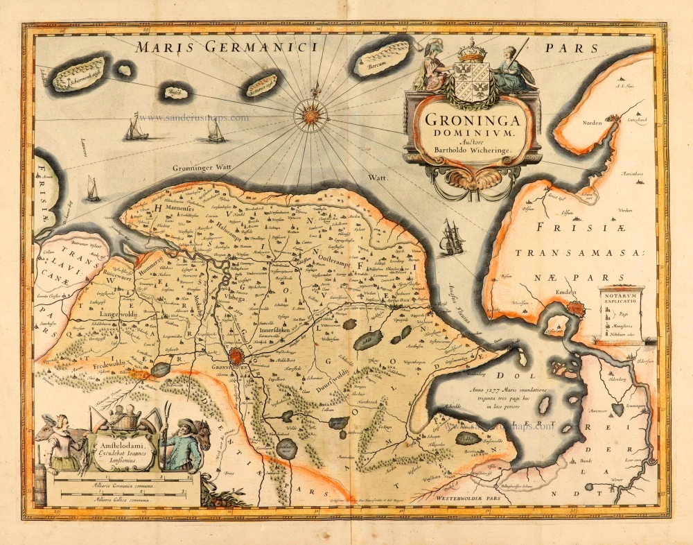
Groninga Dominium. 1632
Groningen, by Joannes Janssonius.
[Item number: 28114]

Tabula Frisiae, Groningae, er Territorii Emdensis nec non circumjacentium Regionum, puta Transisalaniae, Benthemiae, Westphaliae et Oldenburgi. 1656-80
Friesland & Groningen by Nicolaes Visscher I.
[Item number: 28601]

La Seigneurie de Groningue subdivisée en toutes ses Iuridictions. 1692
Groningen by N. Sanson, so-called published by Hubert Jaillot. (Pirated edition by Pierre Mortier).
[Item number: 31452]

Carte de la Seigneurie de Groningue. 1633
Groningen by C. Tassin.
[Item number: 31756]

Groninga opule[n]ta populosa, et valide contra hostiles insultus nivinita Phrisie urbs Ptolemeo Phileum, constracta et denominata a Grunno Anthenoris Regis Francorum fr[atr]e, Anno ante incarnationem Christi, CCCLXXVII ut Humbaldes Schribit : 1612
Groningen, by Ludovicus Guicciardini, after Braun & Hogenberg.
[Item number: 32949]