
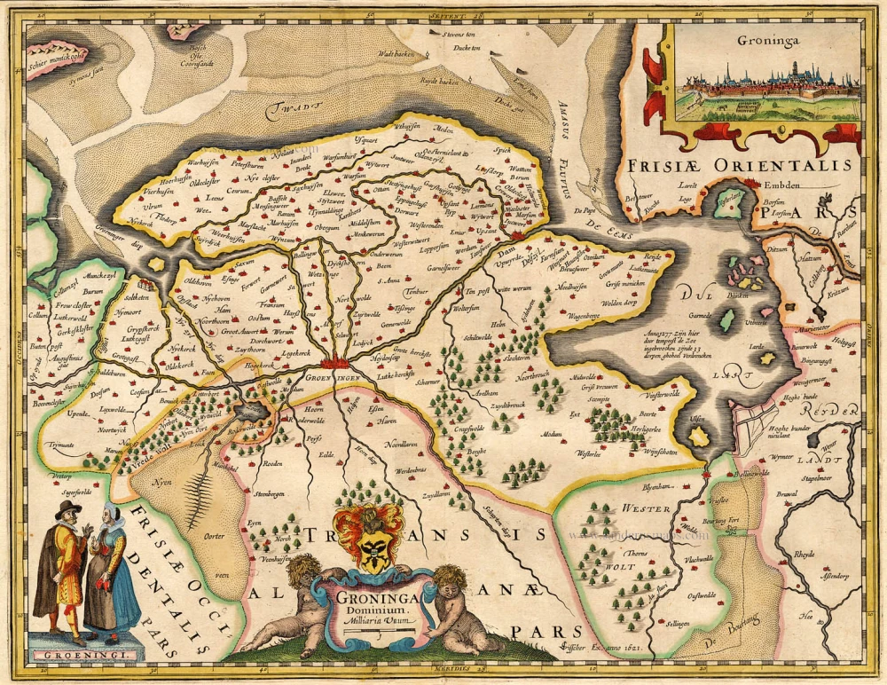
Groningen by Georg Braun & Frans Hogenberg. 1623

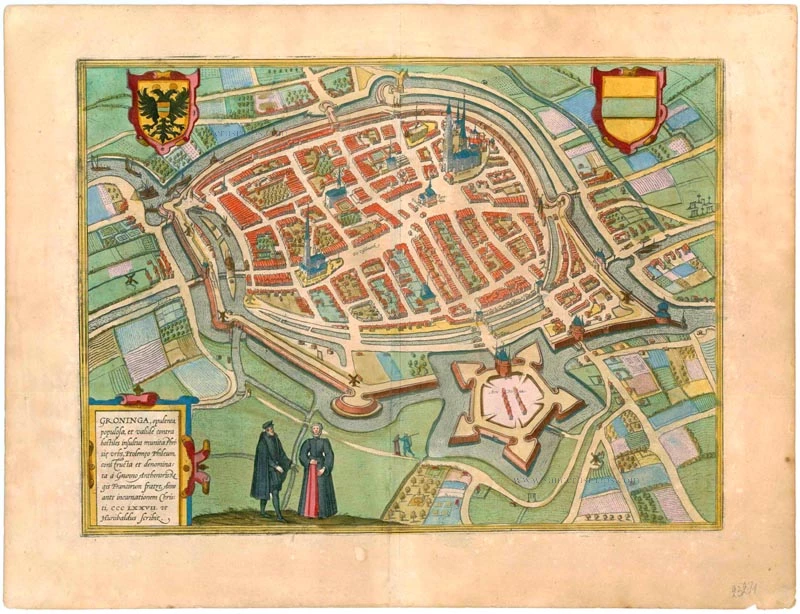
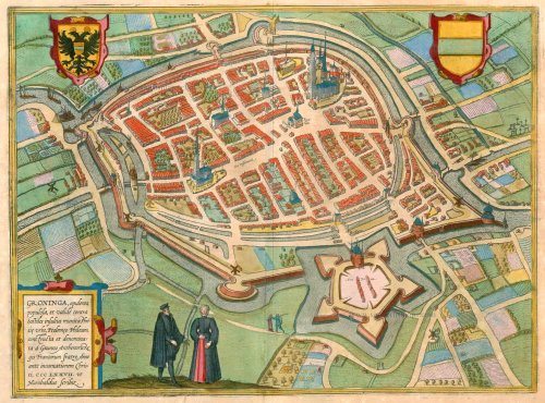

TRANSLATION OF CARTOUCHE TEXT: Groningen, a wealthy and populous Frisian city, strongly fortified against enemy attacks, referred to by Ptolemy as Phileum; built and named by Grunno, brother of the Frankish king Anthenor in AD 377, as written by Hunibald.
COMMENTARY BY BRAUN: "The water is conducted in and through the city in enormous canals built largely by human architecture and artisanship. It is a spacious city with its laws and rules and has authority over many surrounding villages. The city itself possesses many fiefs."
The Old Town is surrounded by canals and dominated by the Grote Markt with the town hall and Martinikerk and by the fish market with the Aakerk. Both churches were originally built in the 13th century but were altered and expanded in the 15th century. To the former belongs the 97-m-high Martinitoren, known locally as the "Old Grey One".
In the 13th century, the city attained great importance because of its favourable position, and it became a Hanseatic city in 1282. Many merchants settled here, and Groningen developed into a flourishing trade centre. In 1536 the city passed first to the Habsburgs and finally in 1594 to the United Netherlands. In 1614 the university was founded. (Taschen)
Braun G. & Hogenberg F. and the Civitates Orbis Terrarum.
The Civitates Orbis Terrarum, also known as the 'Braun & Hogenberg', is a six-volume town atlas and the most excellent book of town views and plans ever published: 363 engravings, sometimes beautifully coloured. It was one of the best-selling works in the last quarter of the 16th century. Georg Braun, a skilled writer, wrote the text accompanying the plans and views on the verso. Many plates were engraved after the original drawings of a professional artist, Joris Hoefnagel (1542-1600). The first volume was published in Latin in 1572 and the sixth in 1617. Frans Hogenberg, a talented engraver, created the tables for volumes I through IV, and Simon van den Neuwel made those for volumes V and VI. Other contributors were cartographers Daniel Freese and Heinrich Rantzau, who provided valuable geographical information. Works by Jacob van Deventer, Sebastian Münster, and Johannes Stumpf were also used as references. Translations appeared in German and French, making the atlas accessible to a broader audience.
Since its original publication of volume 1 in 1572, the Civitates Orbis Terrarum has left an indelible mark on the history of cartography. Seven more editions followed the first volume in 1575, 1577, 1582, 1588, 1593, 1599, and 1612. Vol.2, initially released in 1575, saw subsequent editions in 1597 and 1612. The subsequent volumes, each a treasure trove of historical insights, graced the world in 1581, 1588, 1593, 1599, and 1606. The German translation of the first volume, a testament to its widespread appeal, debuted in 1574, followed by the French edition in 1575.
Several printers were involved: Theodor Graminaeus, Heinrich von Aich, Gottfried von Kempen, Johannis Sinniger, Bertram Buchholtz, and Peter von Brachel, all of whom worked in Cologne.
Georg Braun (1541-1622)
Georg Braun, the author of the text accompanying the plans and views in the Civitates Orbis Terrarum, was born in Cologne in 1541. After his studies in Cologne, he entered the Jesuit Order as a novice, indicating his commitment to learning and intellectual pursuits. In 1561, he obtained his bachelor's degree; in 1562, he received his Magister Artium, further demonstrating his academic achievements. Although he left the Jesuit Order, he continued his studies in theology, gaining a licentiate in theology. His theological background likely influenced the content and tone of the text in the Civitates Orbis Terrarum, adding a unique perspective to the work.
Frans Hogenberg (1535-1590)
Frans Hogenberg was a Flemish and German painter, engraver, and mapmaker. He was born in Mechelen as the son of Nicolaas Hogenberg.
By the end of the 1560s, Frans Hogenberg was employed upon Abraham Ortelius's Theatrum Orbis Terrarum, published in 1570; he is named an engraver of numerous maps. In 1568, he was banned from Antwerp by the Duke of Alva and travelled to London, where he stayed a few years before emigrating to Cologne. He immediately embarked on his two most important works, the Civitates, published in 1572 and the Geschichtsblätter, which appeared in several series from 1569 until about 1587.
Thanks to large-scale projects like the Geschichtsblätter and the Civitates, Hogenberg's social circumstances improved with each passing year. He died as a wealthy man in Cologne in 1590.
Groninga, opulenta, populosa, et valide contra hostiles insultus munita Phrisie urbs,
Item Number: 23271 Authenticity Guarantee
Category: Antique maps > Europe > The Netherlands - Cities
Old, antique bird’s-eye view plan of Groningen, by Georg Braun & Frans Hogenberg.
Title: Groninga, opulenta, populosa, et valide contra hostiles insultus munita Phrisie urbs,
Ptolemeo Phileum, constructa et denominata à Grunno Anthenoris Regis Francorum fratre, Anno ante incarnationem Christi, CCCLXXVI.
ut Hunibaldis Scribit.
Date of the first edition: 1572.
Date of this map: 1623.
Copper engraving, printed on paper.
Size (not including margins): 320 x 436mm (12.6 x 17.17 inches).
Verso: Latin text.
Condition: Original coloured, lower centrefold split reinforced.
Condition Rating: A+.
References: Van der Krogt 4, #1645; Fauser, #5053; Taschen, Br. Hog., p.162
From: Civitates Orbis Terrarum, ... Part 2: De Praecipuis, Totius Universi Urbibus, Liber Secundus. Köln, Petrus von Brachel, 1623. (Van der Krogt 4, 41:1.2)
TRANSLATION OF CARTOUCHE TEXT: Groningen, a wealthy and populous Frisian city, strongly fortified against enemy attacks, referred to by Ptolemy as Phileum; built and named by Grunno, brother of the Frankish king Anthenor in AD 377, as written by Hunibald.
COMMENTARY BY BRAUN: "The water is conducted in and through the city in enormous canals built largely by human architecture and artisanship. It is a spacious city with its laws and rules and has authority over many surrounding villages. The city itself possesses many fiefs."
The Old Town is surrounded by canals and dominated by the Grote Markt with the town hall and Martinikerk and by the fish market with the Aakerk. Both churches were originally built in the 13th century but were altered and expanded in the 15th century. To the former belongs the 97-m-high Martinitoren, known locally as the "Old Grey One".
In the 13th century, the city attained great importance because of its favourable position, and it became a Hanseatic city in 1282. Many merchants settled here, and Groningen developed into a flourishing trade centre. In 1536 the city passed first to the Habsburgs and finally in 1594 to the United Netherlands. In 1614 the university was founded. (Taschen)
Braun G. & Hogenberg F. and the Civitates Orbis Terrarum.
The Civitates Orbis Terrarum, also known as the 'Braun & Hogenberg', is a six-volume town atlas and the most excellent book of town views and plans ever published: 363 engravings, sometimes beautifully coloured. It was one of the best-selling works in the last quarter of the 16th century. Georg Braun, a skilled writer, wrote the text accompanying the plans and views on the verso. Many plates were engraved after the original drawings of a professional artist, Joris Hoefnagel (1542-1600). The first volume was published in Latin in 1572 and the sixth in 1617. Frans Hogenberg, a talented engraver, created the tables for volumes I through IV, and Simon van den Neuwel made those for volumes V and VI. Other contributors were cartographers Daniel Freese and Heinrich Rantzau, who provided valuable geographical information. Works by Jacob van Deventer, Sebastian Münster, and Johannes Stumpf were also used as references. Translations appeared in German and French, making the atlas accessible to a broader audience.
Since its original publication of volume 1 in 1572, the Civitates Orbis Terrarum has left an indelible mark on the history of cartography. Seven more editions followed the first volume in 1575, 1577, 1582, 1588, 1593, 1599, and 1612. Vol.2, initially released in 1575, saw subsequent editions in 1597 and 1612. The subsequent volumes, each a treasure trove of historical insights, graced the world in 1581, 1588, 1593, 1599, and 1606. The German translation of the first volume, a testament to its widespread appeal, debuted in 1574, followed by the French edition in 1575.
Several printers were involved: Theodor Graminaeus, Heinrich von Aich, Gottfried von Kempen, Johannis Sinniger, Bertram Buchholtz, and Peter von Brachel, all of whom worked in Cologne.
Georg Braun (1541-1622)
Georg Braun, the author of the text accompanying the plans and views in the Civitates Orbis Terrarum, was born in Cologne in 1541. After his studies in Cologne, he entered the Jesuit Order as a novice, indicating his commitment to learning and intellectual pursuits. In 1561, he obtained his bachelor's degree; in 1562, he received his Magister Artium, further demonstrating his academic achievements. Although he left the Jesuit Order, he continued his studies in theology, gaining a licentiate in theology. His theological background likely influenced the content and tone of the text in the Civitates Orbis Terrarum, adding a unique perspective to the work.
Frans Hogenberg (1535-1590)
Frans Hogenberg was a Flemish and German painter, engraver, and mapmaker. He was born in Mechelen as the son of Nicolaas Hogenberg.
By the end of the 1560s, Frans Hogenberg was employed upon Abraham Ortelius's Theatrum Orbis Terrarum, published in 1570; he is named an engraver of numerous maps. In 1568, he was banned from Antwerp by the Duke of Alva and travelled to London, where he stayed a few years before emigrating to Cologne. He immediately embarked on his two most important works, the Civitates, published in 1572 and the Geschichtsblätter, which appeared in several series from 1569 until about 1587.
Thanks to large-scale projects like the Geschichtsblätter and the Civitates, Hogenberg's social circumstances improved with each passing year. He died as a wealthy man in Cologne in 1590.
Related items

Groninga, opulenta, populosa, et valide contra hostiles insultus munita Phrisie urbs, ... 1575
Groningen, by Georg Braun and Frans Hogenberg.
[Item number: 8108]

Correctissima nec non Novissima Dominii et Provinciae Groningae et Omlandiae Tabula, ... c. 1680
Groningen, by F. De Wit.
[Item number: 10601]
Groninga Dominium 1634
Groningen, Petrus Kaerius (Pieter Van der Keere).
[Item number: 15473]

Groninga Dominium. 1631
Groningen by G. Mercator / J. Hondius, published by J. Janssonius.
[Item number: 17721]

Very nice colouring
Groninga Dominium / P. Kaerius Ex. 1617. 1617
Groningen by Kaerius Petrus
[Item number: 20513]

Groeninga, sive ut alij, Gruninga, Frisiae urb, ... ([on sheet with] Bouersavia, eius Insule in Zelandia oppidum, .. [and] Goricum, nobile Hollandiae Oppidum 1612
Groningen, Brouwershaven and Gorinchem, by Georg Braun and Frans Hogenberg.
[Item number: 22319]

Groninga Dominium 1642
Groningen by Blaeu W.
[Item number: 22497]

Correctissima nec non Novissima Dominii et Provinciae Groningae et Omlandiae Tabula, ... 1721-41
Groningen, by F. De Wit.
[Item number: 23669]

La Groningue. 1713
Groningen, by Pieter Van der Aa.
[Item number: 26057]

La Seigneurie de Groningue subdivisée en toutes ses Iuridictions. 1692
Groningen by N. Sanson, so-called published by Hubert Jaillot. (Pirated edition by Pierre Mortier).
[Item number: 31452]

Carte de la Seigneurie de Groningue. 1633
Groningen by C. Tassin.
[Item number: 31756]

Groninga opule[n]ta populosa, et valide contra hostiles insultus nivinita Phrisie urbs Ptolemeo Phileum, constracta et denominata a Grunno Anthenoris Regis Francorum fr[atr]e, Anno ante incarnationem Christi, CCCLXXVII ut Humbaldes Schribit : 1612
Groningen, by Ludovicus Guicciardini, after Braun & Hogenberg.
[Item number: 32949]