Groningen, Brouwershaven and Gorinchem, by Georg Braun and Frans Hogenberg. 1612
GRONINGEN
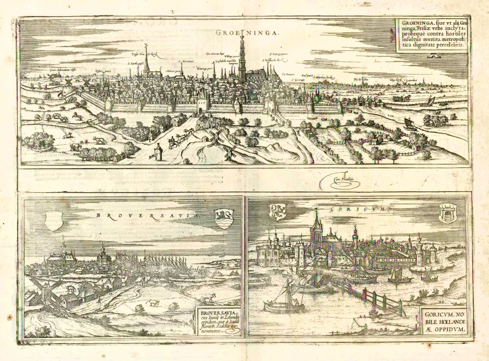
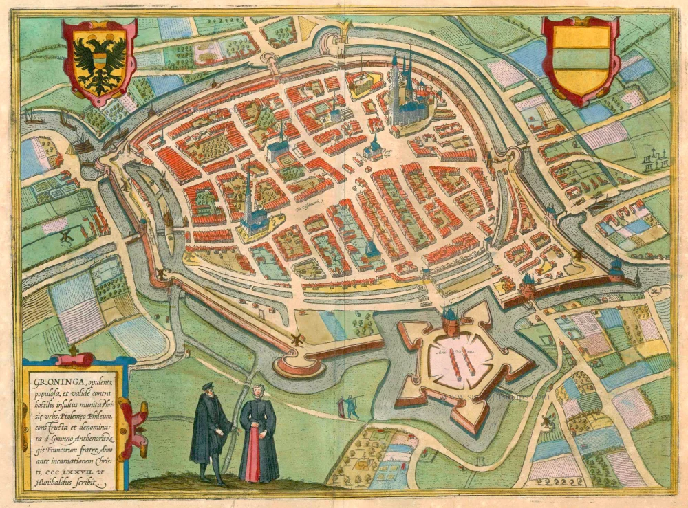
TRANSLATION OF CARTOUCHE TEXT: Groninga, also Groningen, is a well-known city in Frisia, well armed against hostile attacks and famed as a capital.
COMMENTARY BY BRAUN: "Groningen is the capital of Frisia and takes its name from its first founder, Gruno. [...] At that time, it was protected not by walls but only by wooden posts; in 1110, it was made safe against all attacks from enemies through walls, moats and towers. Groningen is now a powerful and populous city embellished with tall spires and splendid houses."
This panoramic view shows Groningen on a small hill from the north: characteristic is the densely packed houses and the Martinitoren, a tall tower in the middle. In the 13th century, the city attained great importance because of its favourable position, and it became a Hanseatic city in 1282. Many merchants settled here, and Groningen developed into a flourishing trade centre. In 1536 the city passed first to the Habsburgs and finally in 1594 to the United Netherlands. In 1614 the university was founded.
BROUWERSHAVEN
TRANSLATION OF CARTOUCHE TEXT: Brouwershaven is a town on the Island of Zeeland, which also bears the cognomen of Scaldia after the River Scalde.
COMMENTARY BY BRAUN: "Zeeland lies on the sea and is spread across numerous islands; richly populated villages, settlements and dairy farms are found there, as well as splendid noblemen's and townhouses and palaces, e.g. Haamstede, Moermondt etc., also a not ignoble stronghold that is called Brouwershaven. It is a small and well-built town, whose inhabitants go out to sea and are industrious fishermen because fish is exported from Brouwershaven to various parts of the world."
The farmhouses in the foreground and the absence of city fortifications lend Brouwershaven a primarily rural character. The town arose in the middle of the 12th century as a port on the Island of Schouwen-Duiveland, directly on Lake Grevelingen in the northern Netherlandish province of Zeeland. It owes its name ("brewers' port") to its earlier involvement in the beer trade: due to the lack of spring water, Zeeland had no brewery of its own in the Middle Ages and so had to import its beer from Holland. The large church of Sint-Nicolaas (left) was begun in 1325, but the town hall would not be built until 1599. After economically difficult times, in the mid-19th century, Brouwerhaven enjoyed renewed prosperity when it temporarily took over Rotterdam's role as a transhipment point for goods and passengers travelling overseas.
GORINCHEM
CARTOUCHE: Gorinchem, a notable town in Flanders.
COMMENTARY BY BRAUN: "Past the town of Gorinchem flows the Waal, one of the three distributaries through which the Rhine empties into the ocean. From a high tower here, one can see 22 towns well fortified with city walls, as well as many dairy farms and noblemen's houses. There are also very fertile pastures here, which enable the inhabitants to produce butter, milk and cheese, which they export to Antwerp and other cities."
It is clear at first sight that fishing is also a tradition in the town of Gorinchem, seen here in the side view. Located in South Holland, Gorinchem was already a walled farming and fishing village by around 1000 and was eventually granted its charter in 1382. The Gothic Grote Kerk, with its Sint-Jans tower some 60 m high, was built in the second half of the 15th century - in the illustration, it dominates all the other buildings in the town. In 1566 Gorinchem's population became Protestant, and during the Eighty Years' War, several Catholic clergymen were murdered here by Geuzen (Netherlandish freedom fighters). After a period of economic decline, the town revived in the 19th century with the building of the railway and inland canals.
Braun G. & Hogenberg F. and the Civitates Orbis Terrarum.
The Civitates Orbis Terrarum, also known as the 'Braun & Hogenberg', is a six-volume town atlas and the most excellent book of town views and plans ever published: 363 engravings, sometimes beautifully coloured. It was one of the best-selling works in the last quarter of the 16th century. Georg Braun, a skilled writer, wrote the text accompanying the plans and views on the verso. Many plates were engraved after the original drawings of a professional artist, Joris Hoefnagel (1542-1600). The first volume was published in Latin in 1572 and the sixth in 1617. Frans Hogenberg, a talented engraver, created the tables for volumes I through IV, and Simon van den Neuwel made those for volumes V and VI. Other contributors were cartographers Daniel Freese and Heinrich Rantzau, who provided valuable geographical information. Works by Jacob van Deventer, Sebastian Münster, and Johannes Stumpf were also used as references. Translations appeared in German and French, making the atlas accessible to a broader audience.
Since its original publication of volume 1 in 1572, the Civitates Orbis Terrarum has left an indelible mark on the history of cartography. Seven more editions followed the first volume in 1575, 1577, 1582, 1588, 1593, 1599, and 1612. Vol.2, initially released in 1575, saw subsequent editions in 1597 and 1612. The subsequent volumes, each a treasure trove of historical insights, graced the world in 1581, 1588, 1593, 1599, and 1606. The German translation of the first volume, a testament to its widespread appeal, debuted in 1574, followed by the French edition in 1575.
Several printers were involved: Theodor Graminaeus, Heinrich von Aich, Gottfried von Kempen, Johannis Sinniger, Bertram Buchholtz, and Peter von Brachel, all of whom worked in Cologne.
Georg Braun (1541-1622)
Georg Braun, the author of the text accompanying the plans and views in the Civitates Orbis Terrarum, was born in Cologne in 1541. After his studies in Cologne, he entered the Jesuit Order as a novice, indicating his commitment to learning and intellectual pursuits. In 1561, he obtained his bachelor's degree; in 1562, he received his Magister Artium, further demonstrating his academic achievements. Although he left the Jesuit Order, he continued his studies in theology, gaining a licentiate in theology. His theological background likely influenced the content and tone of the text in the Civitates Orbis Terrarum, adding a unique perspective to the work.
Frans Hogenberg (1535-1590)
Frans Hogenberg was a Flemish and German painter, engraver, and mapmaker. He was born in Mechelen as the son of Nicolaas Hogenberg.
By the end of the 1560s, Frans Hogenberg was employed upon Abraham Ortelius's Theatrum Orbis Terrarum, published in 1570; he is named an engraver of numerous maps. In 1568, he was banned from Antwerp by the Duke of Alva and travelled to London, where he stayed a few years before emigrating to Cologne. He immediately embarked on his two most important works, the Civitates, published in 1572 and the Geschichtsblätter, which appeared in several series from 1569 until about 1587.
Thanks to large-scale projects like the Geschichtsblätter and the Civitates, Hogenberg's social circumstances improved with each passing year. He died as a wealthy man in Cologne in 1590.
Groeninga, sive ut alij, Gruninga, Frisiae urb, ... ([on sheet with] Bouersavia, eius Insule in Zelandia oppidum, .. [and] Goricum, nobile Hollandiae Oppidum
Item Number: 22319 Authenticity Guarantee
Category: Antique maps > Europe > The Netherlands - Cities
Old antique map with three bird's-eye views by Braun and Hogenberg: Groningen, Brouwershaven and Gorinchem.
Second state: Gorinchem is mentioned as a Hollandisch town.
Title: Groeninga, sive ut alij, Gruninga, Frisiae urb, ... [on sheet with] Bouersavia, eius Insule in Zelandia oppidum, .. [and] Goricum, nobile Hollandiae Oppidum
Date of the first edition: 1572.
Date of this map: 1612.
Copper engraving, printed on paper.
Size (not including margins): 335 x 465mm (13.19 x 18.31 inches).
Verso: Latin text.
Condition: Uncoloured, excellent.
Condition Rating: A+.
From: Civitates Orbis Terrarum, Liber Primus. Cologne, Petrus von Brachel, 1612. (Van der Krogt 4, 41:1.1(1612))
GRONINGEN
TRANSLATION OF CARTOUCHE TEXT: Groninga, also Groningen, is a well-known city in Frisia, well armed against hostile attacks and famed as a capital.
COMMENTARY BY BRAUN: "Groningen is the capital of Frisia and takes its name from its first founder, Gruno. [...] At that time, it was protected not by walls but only by wooden posts; in 1110, it was made safe against all attacks from enemies through walls, moats and towers. Groningen is now a powerful and populous city embellished with tall spires and splendid houses."
This panoramic view shows Groningen on a small hill from the north: characteristic is the densely packed houses and the Martinitoren, a tall tower in the middle. In the 13th century, the city attained great importance because of its favourable position, and it became a Hanseatic city in 1282. Many merchants settled here, and Groningen developed into a flourishing trade centre. In 1536 the city passed first to the Habsburgs and finally in 1594 to the United Netherlands. In 1614 the university was founded.
BROUWERSHAVEN
TRANSLATION OF CARTOUCHE TEXT: Brouwershaven is a town on the Island of Zeeland, which also bears the cognomen of Scaldia after the River Scalde.
COMMENTARY BY BRAUN: "Zeeland lies on the sea and is spread across numerous islands; richly populated villages, settlements and dairy farms are found there, as well as splendid noblemen's and townhouses and palaces, e.g. Haamstede, Moermondt etc., also a not ignoble stronghold that is called Brouwershaven. It is a small and well-built town, whose inhabitants go out to sea and are industrious fishermen because fish is exported from Brouwershaven to various parts of the world."
The farmhouses in the foreground and the absence of city fortifications lend Brouwershaven a primarily rural character. The town arose in the middle of the 12th century as a port on the Island of Schouwen-Duiveland, directly on Lake Grevelingen in the northern Netherlandish province of Zeeland. It owes its name ("brewers' port") to its earlier involvement in the beer trade: due to the lack of spring water, Zeeland had no brewery of its own in the Middle Ages and so had to import its beer from Holland. The large church of Sint-Nicolaas (left) was begun in 1325, but the town hall would not be built until 1599. After economically difficult times, in the mid-19th century, Brouwerhaven enjoyed renewed prosperity when it temporarily took over Rotterdam's role as a transhipment point for goods and passengers travelling overseas.
GORINCHEM
CARTOUCHE: Gorinchem, a notable town in Flanders.
COMMENTARY BY BRAUN: "Past the town of Gorinchem flows the Waal, one of the three distributaries through which the Rhine empties into the ocean. From a high tower here, one can see 22 towns well fortified with city walls, as well as many dairy farms and noblemen's houses. There are also very fertile pastures here, which enable the inhabitants to produce butter, milk and cheese, which they export to Antwerp and other cities."
It is clear at first sight that fishing is also a tradition in the town of Gorinchem, seen here in the side view. Located in South Holland, Gorinchem was already a walled farming and fishing village by around 1000 and was eventually granted its charter in 1382. The Gothic Grote Kerk, with its Sint-Jans tower some 60 m high, was built in the second half of the 15th century - in the illustration, it dominates all the other buildings in the town. In 1566 Gorinchem's population became Protestant, and during the Eighty Years' War, several Catholic clergymen were murdered here by Geuzen (Netherlandish freedom fighters). After a period of economic decline, the town revived in the 19th century with the building of the railway and inland canals.
Braun G. & Hogenberg F. and the Civitates Orbis Terrarum.
The Civitates Orbis Terrarum, also known as the 'Braun & Hogenberg', is a six-volume town atlas and the most excellent book of town views and plans ever published: 363 engravings, sometimes beautifully coloured. It was one of the best-selling works in the last quarter of the 16th century. Georg Braun, a skilled writer, wrote the text accompanying the plans and views on the verso. Many plates were engraved after the original drawings of a professional artist, Joris Hoefnagel (1542-1600). The first volume was published in Latin in 1572 and the sixth in 1617. Frans Hogenberg, a talented engraver, created the tables for volumes I through IV, and Simon van den Neuwel made those for volumes V and VI. Other contributors were cartographers Daniel Freese and Heinrich Rantzau, who provided valuable geographical information. Works by Jacob van Deventer, Sebastian Münster, and Johannes Stumpf were also used as references. Translations appeared in German and French, making the atlas accessible to a broader audience.
Since its original publication of volume 1 in 1572, the Civitates Orbis Terrarum has left an indelible mark on the history of cartography. Seven more editions followed the first volume in 1575, 1577, 1582, 1588, 1593, 1599, and 1612. Vol.2, initially released in 1575, saw subsequent editions in 1597 and 1612. The subsequent volumes, each a treasure trove of historical insights, graced the world in 1581, 1588, 1593, 1599, and 1606. The German translation of the first volume, a testament to its widespread appeal, debuted in 1574, followed by the French edition in 1575.
Several printers were involved: Theodor Graminaeus, Heinrich von Aich, Gottfried von Kempen, Johannis Sinniger, Bertram Buchholtz, and Peter von Brachel, all of whom worked in Cologne.
Georg Braun (1541-1622)
Georg Braun, the author of the text accompanying the plans and views in the Civitates Orbis Terrarum, was born in Cologne in 1541. After his studies in Cologne, he entered the Jesuit Order as a novice, indicating his commitment to learning and intellectual pursuits. In 1561, he obtained his bachelor's degree; in 1562, he received his Magister Artium, further demonstrating his academic achievements. Although he left the Jesuit Order, he continued his studies in theology, gaining a licentiate in theology. His theological background likely influenced the content and tone of the text in the Civitates Orbis Terrarum, adding a unique perspective to the work.
Frans Hogenberg (1535-1590)
Frans Hogenberg was a Flemish and German painter, engraver, and mapmaker. He was born in Mechelen as the son of Nicolaas Hogenberg.
By the end of the 1560s, Frans Hogenberg was employed upon Abraham Ortelius's Theatrum Orbis Terrarum, published in 1570; he is named an engraver of numerous maps. In 1568, he was banned from Antwerp by the Duke of Alva and travelled to London, where he stayed a few years before emigrating to Cologne. He immediately embarked on his two most important works, the Civitates, published in 1572 and the Geschichtsblätter, which appeared in several series from 1569 until about 1587.
Thanks to large-scale projects like the Geschichtsblätter and the Civitates, Hogenberg's social circumstances improved with each passing year. He died as a wealthy man in Cologne in 1590.

