
Friesland & Groningen by Nicolaes Visscher I. 1656-80


The Visscher Family
For nearly a century, the members of the Visscher family were essential art dealers and map publishers in Amsterdam.
Claes Jansz. Visscher, or N.J. Piscator (1587-1652)
Claes Jansz. Vischer bought a house in Amsterdam, 'de gulden Bors', on the crucial Kalverstraat and changed the name into "In de Visscher"; under this title, the shop was to flourish for many years.
He was famous for his engravings and etchings of Dutch landscapes and 'historical scenes', such as sieges, battles, etc. These 'historical scenes' were considered contemporary illustrated news items, especially e.g. that of 'the Eighty Years' War'.
For the publication of his first atlas, he bought copperplates of the atlas Germania Inferior by Pieter van den Keere (1623).
In 1649, he published an atlas entitled Tabularum Geographicarum Contractarum, containing the same maps as Langenes' Caert Thresoor, for which Visscher had only new title pages engraved.
Claes Jansz. Visscher died in 1652. His wife, Neeltjen Florisdr., had already died in 1640. They had seven children, four of whom were still alive at Claes Jansz.'s death. One was Nicolaes Visscher I, who was to continue his father's business.
Nicolaes Visscher I (1618-1679)
Nicolaes Visscher I partnered with his father, continued the business, and stayed on the Kalverstraat 'in de Visscher' till his death.
In about 1657, the first edition of his Atlas Contractus Orbis Terrarum appeared.
Between 1664 and 1677, several editions of his Atlas Contractus appeared without a printed index, for these atlases had no fixed contents but were composed according to the buyer's financial leaping pole.
In May 1664, Nicolaes Visscher was admitted as a member of the Booksellers' Guild of his town. In July 1677, he was granted a patent of the States of Holland and West-Friesland for printing and publishing maps and atlases for 15 years.
After this, he again published an Atlas Contractus with a printed index. At about the same time, he also brought out an Atlas Minor.
Nicolaes Visscher II (1649-1702)
Nicolaes Visscher II inherited the 'shop' from his father. To obtain a new privilege, he applied to the States of Holland and West-Friesland in 1682 for a patent for printing and publishing maps. This patent was granted to him the same year. He moved the firm to the Dam, but it kept the same signboard: "In de Visscher".
Around 1683, he published his first Atlas Minor with a printed index of 91 maps. In 1684, an atlas Germania Inferior appeared. Till 1697, he published another number of atlases. He used his grandfather's (Claes Jansz.) maps less often now and relied more and more on his own.
The wars waged at this time initiated the compilation of maps of the countries where the armies operated. Many war maps were included in the various editions of his Atlas Minor.
After Nicolaes's death, his wife, Elizabeth Verseyl, published all the war maps as an atlas under the title De Stoel des Oorlogs in de Wereld (The seat of war in the world).
The widow of Nicolaes Visscher II (?-1726)
His widow continued the business energetically, and by her hand, under the name of her deceased husband, numerous atlases appeared, e.g., several editions of the Atlas Minor, an Atlas Maior and De Stoel des Oorlogs. The shop enjoyed a high reputation due to the assortment's incredible variety. Not only 'Visscher' maps but also maps of other publishers were obtainable. With the death of Elizabeth Verseyl in 1726, the last descendant died of a great map- and atlas-publishing firm in Amsterdam.
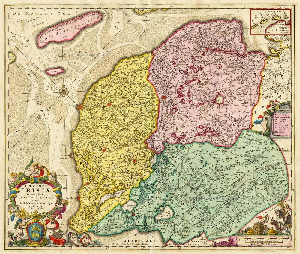
Tabula Frisiae, Groningae, er Territorii Emdensis nec non circumjacentium Regionum, puta Transisalaniae, Benthemiae, Westphaliae et Oldenburgi.
Item Number: 28601 Authenticity Guarantee
Category: Antique maps > Europe > The Netherlands
Old, antique map of Friesland & Groningen, by Nicolaes Visscher I.
Title: Tabula Frisiae, Groningae, er Territorii Emdensis nec non circumjacentium Regionum, puta Transisalaniae, Benthemiae, Westphaliae et Oldenburgi.
Ex Officina N. Visscher.
Date of the first edition: c. 1656.
Date of this map: 1656-80.
Copper engraving, printed on paper.
Map size: 434 x 544mm (17.09 x 21.42 inches).
Sheet size: 540 x 615mm (21.26 x 24.21 inches).
Verso: Blank.
Condition: Original coloured, excellent.
Condition Rating: A+.
References: Schilder, #65.9
References: Schilder 6 - #65.9; de Rijke (Friesland) - #36.9
From: Atlas Contractus Orbis Terrarum Praecipuas ac Novissimas Complectens Tabulas. Amsterdam, N. Visscher, 1656-80. (Koeman III, Vis5-8)
The Visscher Family
For nearly a century, the members of the Visscher family were essential art dealers and map publishers in Amsterdam.
Claes Jansz. Visscher, or N.J. Piscator (1587-1652)
Claes Jansz. Vischer bought a house in Amsterdam, 'de gulden Bors', on the crucial Kalverstraat and changed the name into "In de Visscher"; under this title, the shop was to flourish for many years.
He was famous for his engravings and etchings of Dutch landscapes and 'historical scenes', such as sieges, battles, etc. These 'historical scenes' were considered contemporary illustrated news items, especially e.g. that of 'the Eighty Years' War'.
For the publication of his first atlas, he bought copperplates of the atlas Germania Inferior by Pieter van den Keere (1623).
In 1649, he published an atlas entitled Tabularum Geographicarum Contractarum, containing the same maps as Langenes' Caert Thresoor, for which Visscher had only new title pages engraved.
Claes Jansz. Visscher died in 1652. His wife, Neeltjen Florisdr., had already died in 1640. They had seven children, four of whom were still alive at Claes Jansz.'s death. One was Nicolaes Visscher I, who was to continue his father's business.
Nicolaes Visscher I (1618-1679)
Nicolaes Visscher I partnered with his father, continued the business, and stayed on the Kalverstraat 'in de Visscher' till his death.
In about 1657, the first edition of his Atlas Contractus Orbis Terrarum appeared.
Between 1664 and 1677, several editions of his Atlas Contractus appeared without a printed index, for these atlases had no fixed contents but were composed according to the buyer's financial leaping pole.
In May 1664, Nicolaes Visscher was admitted as a member of the Booksellers' Guild of his town. In July 1677, he was granted a patent of the States of Holland and West-Friesland for printing and publishing maps and atlases for 15 years.
After this, he again published an Atlas Contractus with a printed index. At about the same time, he also brought out an Atlas Minor.
Nicolaes Visscher II (1649-1702)
Nicolaes Visscher II inherited the 'shop' from his father. To obtain a new privilege, he applied to the States of Holland and West-Friesland in 1682 for a patent for printing and publishing maps. This patent was granted to him the same year. He moved the firm to the Dam, but it kept the same signboard: "In de Visscher".
Around 1683, he published his first Atlas Minor with a printed index of 91 maps. In 1684, an atlas Germania Inferior appeared. Till 1697, he published another number of atlases. He used his grandfather's (Claes Jansz.) maps less often now and relied more and more on his own.
The wars waged at this time initiated the compilation of maps of the countries where the armies operated. Many war maps were included in the various editions of his Atlas Minor.
After Nicolaes's death, his wife, Elizabeth Verseyl, published all the war maps as an atlas under the title De Stoel des Oorlogs in de Wereld (The seat of war in the world).
The widow of Nicolaes Visscher II (?-1726)
His widow continued the business energetically, and by her hand, under the name of her deceased husband, numerous atlases appeared, e.g., several editions of the Atlas Minor, an Atlas Maior and De Stoel des Oorlogs. The shop enjoyed a high reputation due to the assortment's incredible variety. Not only 'Visscher' maps but also maps of other publishers were obtainable. With the death of Elizabeth Verseyl in 1726, the last descendant died of a great map- and atlas-publishing firm in Amsterdam.
Related items

Tabula Comitatus Frisiae. Auctore B: Schotano à Sterringa. c. 1680
Friesland, by Frederik De Wit.
[Item number: 2635]

Charte von Friesland 1759-1784
Friesland by Homann Heirs.
[Item number: 13868]

Groninga Dominium. 1631
Groningen by G. Mercator / J. Hondius, published by J. Janssonius.
[Item number: 17721]
Dominii Frisiae Tabula, inter Flevum et Lavicam. c. 1678
Friesland by Nicolaas Visscher II.
[Item number: 18688]

Westfalia Cum Dioecesi Bremensi 1595
Ost-Friesland, Oldenburg, and Bremen by Gerard Mercator.
[Item number: 19091]

Frisia Occidentalis. 1635
Friesland, by Willem Blaeu.
[Item number: 21015]

Groninga Dominium 1642
Groningen by Blaeu W.
[Item number: 22497]

Tabula Comitatus Frisiae. Auctore B: Schotano à Sterringa. c. 1715
Friesland by Frederik de Wit.
[Item number: 23665]

Frisiae Dominium vernacule Friesland, Ca. 1730
Friesland, by Ottens R. & I.
[Item number: 25746]

La Frise. 1713
Friesland by P. Van der Aa.
[Item number: 26064]
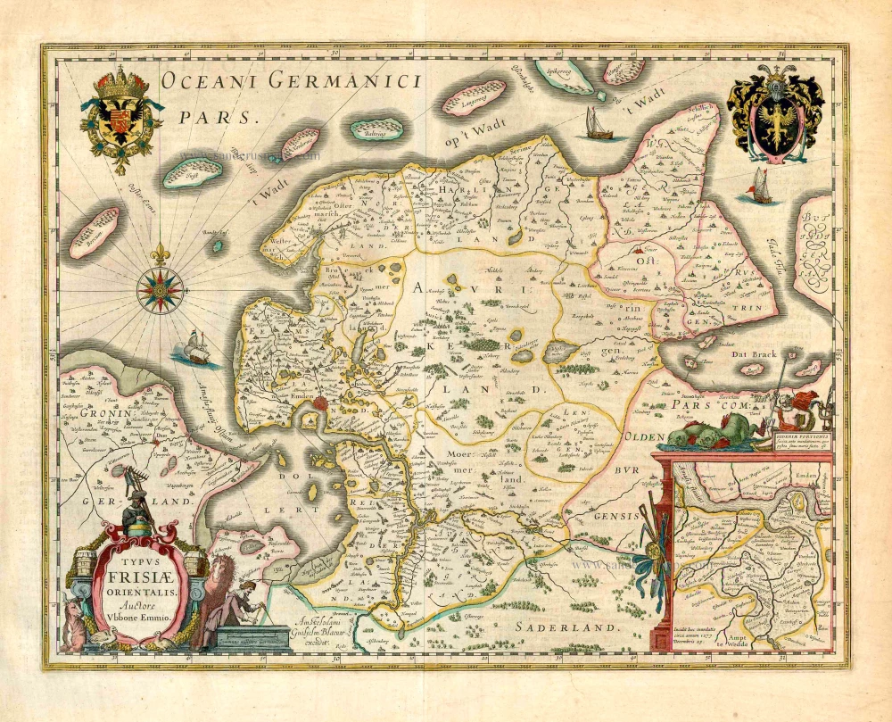
Typus Frisiae Orientalis. 1643
Ost-Friesland, by Willem Blaeu.
[Item number: 27110]

Frisia Occidentalis. c. 1630-1650
West-Friesland, by Henricus Hondius.
[Item number: 31219]

La Seigneurie d'Ouest-Frise ou Frise Occidentale, divisée en ses Trois Parties, subdivisées en leurs Iuridictions. 1692
West-Friesland by N. Sanson, so-called published by Hubert Jaillot. (Pirated edition by Pierre Mortier).
[Item number: 31376]

La Seigneurie de Groningue subdivisée en toutes ses Iuridictions. 1692
Groningen by N. Sanson, so-called published by Hubert Jaillot. (Pirated edition by Pierre Mortier).
[Item number: 31452]

Carte de la Frise Occidentale. 1633
Friesland by C. Tassin.
[Item number: 31755]

Carte de la Seigneurie de Groningue. 1633
Groningen by C. Tassin.
[Item number: 31756]

Groninga opule[n]ta populosa, et valide contra hostiles insultus nivinita Phrisie urbs Ptolemeo Phileum, constracta et denominata a Grunno Anthenoris Regis Francorum fr[atr]e, Anno ante incarnationem Christi, CCCLXXVII ut Humbaldes Schribit : 1612
Groningen, by Ludovicus Guicciardini, after Braun & Hogenberg.
[Item number: 32949]