
Bolsward, Stavoren, Harlingen, Hindelopen by Braun & Hogenberg. 1599

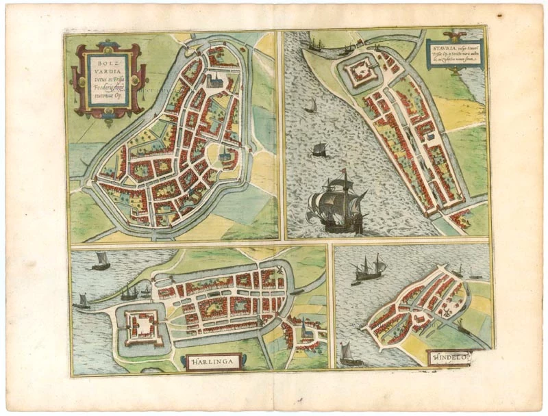
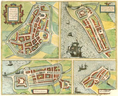

BOLSWARD
CARTOUCHE: Bolsward, an old Hanseatic Frisian town.
COMMENTARY BY BRAUN (on verso): "Bolsward lies only one mile north of Sneek and three miles from Leeuwarden. The fact that it is united with other brave and famous cities in the German Hanseatic League proves that it was considered an old and famous city in earlier times. Thus, in this region's provincial diets and other assemblies, it is considered the first after Leeuwarden and ranks second in dignity."
STAVOREN
CARTOUCHE: Stavria, commonly known as Stavoren, is a Frisian town in the narrowest part of the Southern Sea, which bears the name Zuiderzee.
COMMENTARY BY BRAUN (on verso): "Stavoren, two miles from Sloten, lies on the banks of the Southern Sea [...]. It was once such a wealthy and handsome trade city that it was one of the chief cities in the German Hanseatic League. And although it lost its high-status many years ago, it still enjoys many privileges abroad."
This is a bird's-eye view of the town from the south. In the north, a castle surrounded by a moat and four bastions can be seen, as can the church in the centre of the town. Stavoren is considered to be the oldest town in Friesland. It is a port, and salt was exported from here as early as the 10th century; it was granted a municipal charter in 1060. However, in the 14th century, little remained to show that it had once been prosperous; its temporary use as a naval base during the Guelders War did not lead to a lasting revival.
HARLINGEN
COMMENTARY BY BRAUN (on verso): "Harlingen lies at the entrance of the Zuiderzee, far to the north of the other sea towns [...]. It has a fine and well-fortified castle and a harbour that is very convenient for seafarers not only because of its width and capacity but also of the town's location."
This is a bird's-eye view of the town from the south. The most prominent features are the castle surrounded by a moat, and the Romanesque Grote Kerk, which is to the southeast of the town, outside the walls. Harlingen was created from two dwelling mounds that are still distinctly recognizable. It was granted a municipal charter in 1234 and maintained commercial ties with Hamburg, Denmark and the Baltic countries, but it never joined the Hanseatic League. Harlingen became the last Frisian port with access to the North Sea after the dam's completion in 1932.
HINDELOOPEN
COMMENTARY BY BRAUN (on verso): "Hindeloopen is located not far from Stavoren and stretches into the sea like a promontory, exposed to the waves not just at a point but on all sides. The town is thus in perpetual danger of destruction, despite the effort put into building sturdy, broad and high embankments (thrown up to restrain the stormy sea and protect the town and the neighbouring fields from its violence).
This is a bird's-eye view from the south of the little town projecting into the sea; canals permit small boats to sail into the centre of it. It is known that there was a settlement here in the 8th century AD. The town was granted a municipal charter in 1372 and was one of the 11 Frisian cities. In the 14th century, it was an important Hanseatic city, maintaining trade ties mainly with Scandinavia. These trade activities are indicated by the sailing ship anchored before the town. (Taschen)
Braun G. & Hogenberg F. and the Civitates Orbis Terrarum.
The Civitates Orbis Terrarum, also known as the 'Braun & Hogenberg', is a six-volume town atlas and the most excellent book of town views and plans ever published: 363 engravings, sometimes beautifully coloured. It was one of the best-selling works in the last quarter of the 16th century. Georg Braun, a skilled writer, wrote the text accompanying the plans and views on the verso. Many plates were engraved after the original drawings of a professional artist, Joris Hoefnagel (1542-1600). The first volume was published in Latin in 1572 and the sixth in 1617. Frans Hogenberg, a talented engraver, created the tables for volumes I through IV, and Simon van den Neuwel made those for volumes V and VI. Other contributors were cartographers Daniel Freese and Heinrich Rantzau, who provided valuable geographical information. Works by Jacob van Deventer, Sebastian Münster, and Johannes Stumpf were also used as references. Translations appeared in German and French, making the atlas accessible to a broader audience.
Since its original publication of volume 1 in 1572, the Civitates Orbis Terrarum has left an indelible mark on the history of cartography. Seven more editions followed the first volume in 1575, 1577, 1582, 1588, 1593, 1599, and 1612. Vol.2, initially released in 1575, saw subsequent editions in 1597 and 1612. The subsequent volumes, each a treasure trove of historical insights, graced the world in 1581, 1588, 1593, 1599, and 1606. The German translation of the first volume, a testament to its widespread appeal, debuted in 1574, followed by the French edition in 1575.
Several printers were involved: Theodor Graminaeus, Heinrich von Aich, Gottfried von Kempen, Johannis Sinniger, Bertram Buchholtz, and Peter von Brachel, all of whom worked in Cologne.
Georg Braun (1541-1622)
Georg Braun, the author of the text accompanying the plans and views in the Civitates Orbis Terrarum, was born in Cologne in 1541. After his studies in Cologne, he entered the Jesuit Order as a novice, indicating his commitment to learning and intellectual pursuits. In 1561, he obtained his bachelor's degree; in 1562, he received his Magister Artium, further demonstrating his academic achievements. Although he left the Jesuit Order, he continued his studies in theology, gaining a licentiate in theology. His theological background likely influenced the content and tone of the text in the Civitates Orbis Terrarum, adding a unique perspective to the work.
Frans Hogenberg (1535-1590)
Frans Hogenberg was a Flemish and German painter, engraver, and mapmaker. He was born in Mechelen as the son of Nicolaas Hogenberg.
By the end of the 1560s, Frans Hogenberg was employed upon Abraham Ortelius's Theatrum Orbis Terrarum, published in 1570; he is named an engraver of numerous maps. In 1568, he was banned from Antwerp by the Duke of Alva and travelled to London, where he stayed a few years before emigrating to Cologne. He immediately embarked on his two most important works, the Civitates, published in 1572 and the Geschichtsblätter, which appeared in several series from 1569 until about 1587.
Thanks to large-scale projects like the Geschichtsblätter and the Civitates, Hogenberg's social circumstances improved with each passing year. He died as a wealthy man in Cologne in 1590.
Bolzvardia vetus in Frisia Foederis Anzae teurinicae Op. [on sheet with] Stavria, vulgo Stavere ... [and] Harlinga [and] Hindelop.
Item Number: 22261 Authenticity Guarantee
Category: Antique maps > Europe > The Netherlands - Cities
Antique map with four bird's-eye view plans by Braun and Hogenberg: Bolsward, Stavoren, Harlingen, Hindelopen.
Title: Bolzvardia vetus in Frisia Foederis Anzae teurinicae Op. [on sheet with] Stavria, vulgo Stavere ... [and] Harlinga [and] Hindelop.
Date of the first edition: 1588.
Date of this map: 1599.
Copper engraving, printed on paper.
Size (excluding margins): 360 x 443mm (14.17 x 17.44 inches).
Verso: Latin text.
Condition: Original coloured, excellent.
Condition Rating: A+.
From: Liber quartus Urbium Praecipuarum totius Mundi. Cologne, Bertram Buchholtz, 1599. (Van der Krogt 4, 41:1.4(1599))
BOLSWARD
CARTOUCHE: Bolsward, an old Hanseatic Frisian town.
COMMENTARY BY BRAUN (on verso): "Bolsward lies only one mile north of Sneek and three miles from Leeuwarden. The fact that it is united with other brave and famous cities in the German Hanseatic League proves that it was considered an old and famous city in earlier times. Thus, in this region's provincial diets and other assemblies, it is considered the first after Leeuwarden and ranks second in dignity."
STAVOREN
CARTOUCHE: Stavria, commonly known as Stavoren, is a Frisian town in the narrowest part of the Southern Sea, which bears the name Zuiderzee.
COMMENTARY BY BRAUN (on verso): "Stavoren, two miles from Sloten, lies on the banks of the Southern Sea [...]. It was once such a wealthy and handsome trade city that it was one of the chief cities in the German Hanseatic League. And although it lost its high-status many years ago, it still enjoys many privileges abroad."
This is a bird's-eye view of the town from the south. In the north, a castle surrounded by a moat and four bastions can be seen, as can the church in the centre of the town. Stavoren is considered to be the oldest town in Friesland. It is a port, and salt was exported from here as early as the 10th century; it was granted a municipal charter in 1060. However, in the 14th century, little remained to show that it had once been prosperous; its temporary use as a naval base during the Guelders War did not lead to a lasting revival.
HARLINGEN
COMMENTARY BY BRAUN (on verso): "Harlingen lies at the entrance of the Zuiderzee, far to the north of the other sea towns [...]. It has a fine and well-fortified castle and a harbour that is very convenient for seafarers not only because of its width and capacity but also of the town's location."
This is a bird's-eye view of the town from the south. The most prominent features are the castle surrounded by a moat, and the Romanesque Grote Kerk, which is to the southeast of the town, outside the walls. Harlingen was created from two dwelling mounds that are still distinctly recognizable. It was granted a municipal charter in 1234 and maintained commercial ties with Hamburg, Denmark and the Baltic countries, but it never joined the Hanseatic League. Harlingen became the last Frisian port with access to the North Sea after the dam's completion in 1932.
HINDELOOPEN
COMMENTARY BY BRAUN (on verso): "Hindeloopen is located not far from Stavoren and stretches into the sea like a promontory, exposed to the waves not just at a point but on all sides. The town is thus in perpetual danger of destruction, despite the effort put into building sturdy, broad and high embankments (thrown up to restrain the stormy sea and protect the town and the neighbouring fields from its violence).
This is a bird's-eye view from the south of the little town projecting into the sea; canals permit small boats to sail into the centre of it. It is known that there was a settlement here in the 8th century AD. The town was granted a municipal charter in 1372 and was one of the 11 Frisian cities. In the 14th century, it was an important Hanseatic city, maintaining trade ties mainly with Scandinavia. These trade activities are indicated by the sailing ship anchored before the town. (Taschen)
Braun G. & Hogenberg F. and the Civitates Orbis Terrarum.
The Civitates Orbis Terrarum, also known as the 'Braun & Hogenberg', is a six-volume town atlas and the most excellent book of town views and plans ever published: 363 engravings, sometimes beautifully coloured. It was one of the best-selling works in the last quarter of the 16th century. Georg Braun, a skilled writer, wrote the text accompanying the plans and views on the verso. Many plates were engraved after the original drawings of a professional artist, Joris Hoefnagel (1542-1600). The first volume was published in Latin in 1572 and the sixth in 1617. Frans Hogenberg, a talented engraver, created the tables for volumes I through IV, and Simon van den Neuwel made those for volumes V and VI. Other contributors were cartographers Daniel Freese and Heinrich Rantzau, who provided valuable geographical information. Works by Jacob van Deventer, Sebastian Münster, and Johannes Stumpf were also used as references. Translations appeared in German and French, making the atlas accessible to a broader audience.
Since its original publication of volume 1 in 1572, the Civitates Orbis Terrarum has left an indelible mark on the history of cartography. Seven more editions followed the first volume in 1575, 1577, 1582, 1588, 1593, 1599, and 1612. Vol.2, initially released in 1575, saw subsequent editions in 1597 and 1612. The subsequent volumes, each a treasure trove of historical insights, graced the world in 1581, 1588, 1593, 1599, and 1606. The German translation of the first volume, a testament to its widespread appeal, debuted in 1574, followed by the French edition in 1575.
Several printers were involved: Theodor Graminaeus, Heinrich von Aich, Gottfried von Kempen, Johannis Sinniger, Bertram Buchholtz, and Peter von Brachel, all of whom worked in Cologne.
Georg Braun (1541-1622)
Georg Braun, the author of the text accompanying the plans and views in the Civitates Orbis Terrarum, was born in Cologne in 1541. After his studies in Cologne, he entered the Jesuit Order as a novice, indicating his commitment to learning and intellectual pursuits. In 1561, he obtained his bachelor's degree; in 1562, he received his Magister Artium, further demonstrating his academic achievements. Although he left the Jesuit Order, he continued his studies in theology, gaining a licentiate in theology. His theological background likely influenced the content and tone of the text in the Civitates Orbis Terrarum, adding a unique perspective to the work.
Frans Hogenberg (1535-1590)
Frans Hogenberg was a Flemish and German painter, engraver, and mapmaker. He was born in Mechelen as the son of Nicolaas Hogenberg.
By the end of the 1560s, Frans Hogenberg was employed upon Abraham Ortelius's Theatrum Orbis Terrarum, published in 1570; he is named an engraver of numerous maps. In 1568, he was banned from Antwerp by the Duke of Alva and travelled to London, where he stayed a few years before emigrating to Cologne. He immediately embarked on his two most important works, the Civitates, published in 1572 and the Geschichtsblätter, which appeared in several series from 1569 until about 1587.
Thanks to large-scale projects like the Geschichtsblätter and the Civitates, Hogenberg's social circumstances improved with each passing year. He died as a wealthy man in Cologne in 1590.
Related items

Nymmegen - Noviomagium sive Nouiomagum vulgo Nijmmegen inclyta quoda Francorum Regia Urbs Gelriae primaria. 1582
Nijmegen, by Braun & Hogenberg.
[Item number: 14229]

Lewardum. Occidentalis Frisiae Opp: 1580. [on sheet with:] Franicher, Nobiliu hominum, in Frisia Occidentali, ut plurimum saedes. 1581-88
Leeuwarden & Franeker by Braun & Hogenberg.
[Item number: 20439]

Urbis Campensis ad Isalam Fluvium Icon. 1581-88
Kampen, by Georg Braun and Frans Hogenberg.
[Item number: 22215]
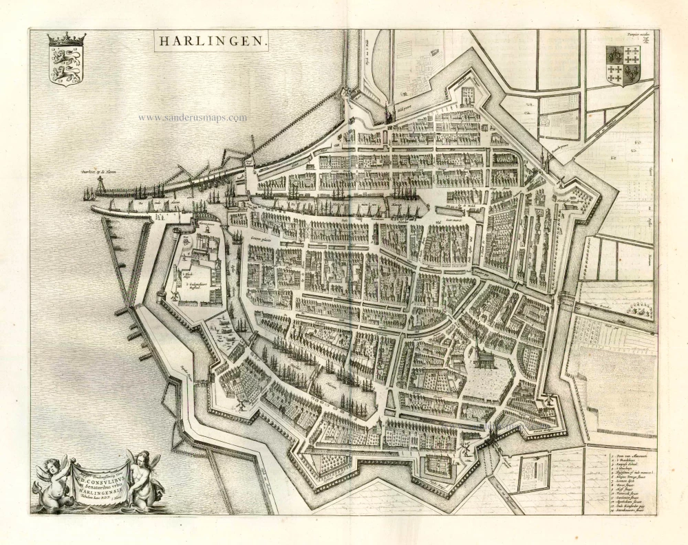
Harlingen. 1649
Harlingen, by Joan Blaeu.
[Item number: 25348]
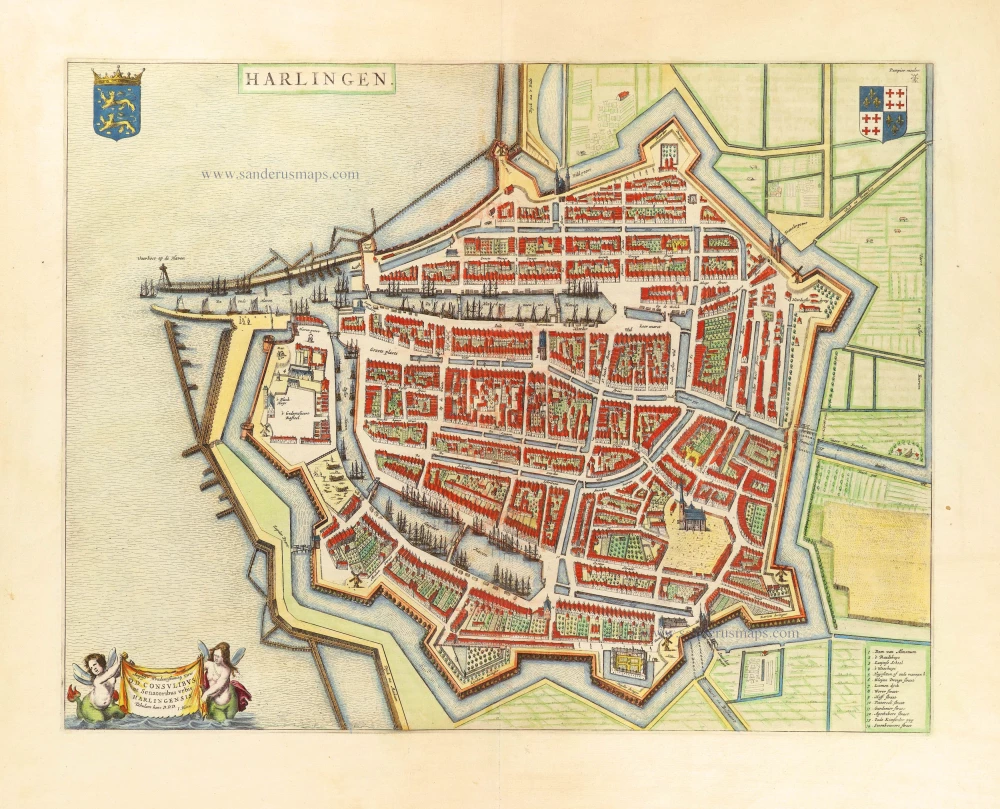
Harlingen. 1652
Harlingen by Joan Blaeu.
[Item number: 28716]