
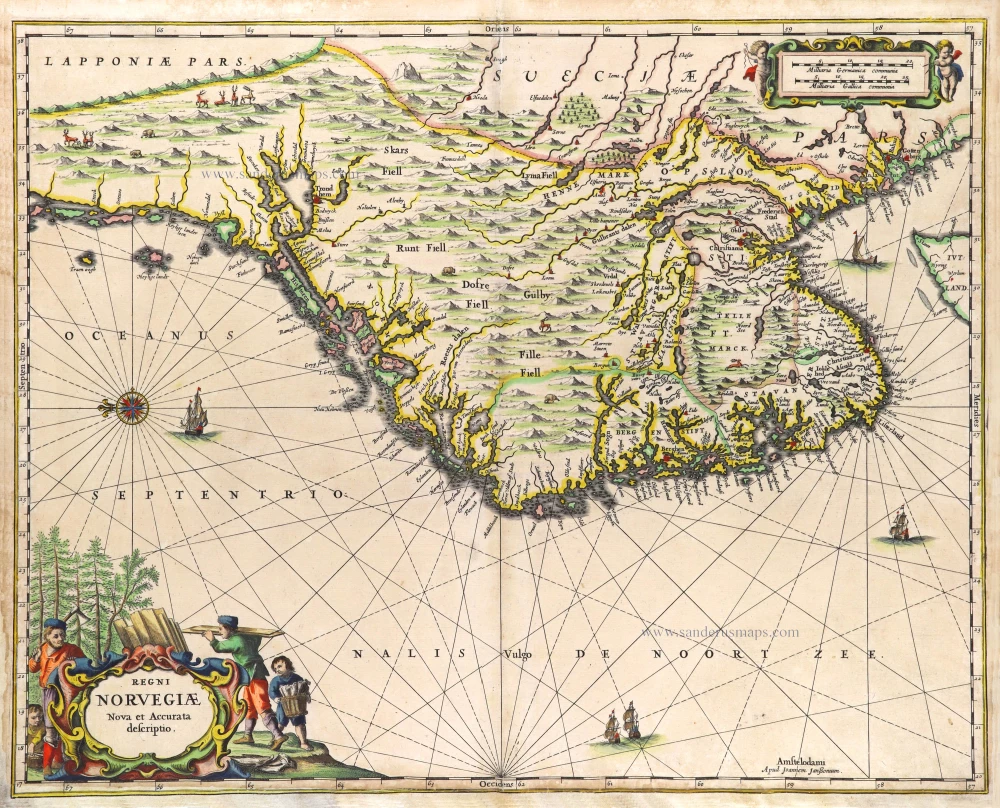
Norway, by Antonio Zatta. 1779-1785

Antonio Zatta (ca. 1722-1804)
Antonio Zatta was an influential Italian cartographer and publisher based in Venice during the 18th century. As one of the last great mapmakers of the Italian Enlightenment, Zatta played a crucial role in preserving and advancing the art of cartography at a time when Venice's status as a centre for mapmaking was in decline.
Little is known about his early life, but Zatta established himself as a prolific publisher and printer, producing a wide range of works including atlases, city plans, and historical maps. His most celebrated achievement is the Atlante Novissimo, published between 1775 and 1785. This monumental four-volume atlas is considered one of the finest Italian cartographic productions of its time. It combined contemporary geographical knowledge with elegant artistry, featuring detailed hand-coloured maps, elaborate title cartouches, and decorative embellishments characteristic of the late Baroque style.
Zatta’s work is notable for incorporating the latest geographical discoveries alongside classical and historical information, reflecting the Enlightenment's emphasis on reason, exploration, and empirical knowledge. He published maps covering all parts of the known world, including detailed representations of Europe, the Americas, and Asia, often updating older cartographic models with new data from explorers and diplomats.
Among his notable contributions is one of the earliest printed maps depicting the newly independent United States after the American Revolutionary War. Zatta's 1778 map, "Gli Stati Uniti della America Settentrionale," adapted English and French sources, marking a significant moment in the cartographic recognition of the United States.
Antonio Zatta's legacy endures through the beauty and precision of his maps, which continue to be prized by collectors and historians alike for their artistic merit and historical value. His works offer a window into the geographical understanding and visual culture of the 18th century, securing his place among the notable figures of cartographic history.
La Norvegia divisa nelle sue Provincie
Item Number: 31892 Authenticity Guarantee
Category: Antique maps > Europe > Northern Europe
Norway, by Antonio Zatta.
Title: La Norvegia divisa nelle sue Provincie
di nuova Projezione.
Venezia 1781 | Presso Antonio Zatta.
Con Privilegio dell' Eccmo Senato.
G. Zuliani inc. G Pitteri scr.
Engraver: Giuliano Zuliani & Giovanni Pitteri.
Date of the first edition: 1779-1785.
Date of this map: 1779-1785.
Date on map: 1781.
Copper engraving, printed on paper.
Image size: 405 x 315mm (16 x 12½ inches).
Sheet size: 500 x 385mm (19¾ x 15¼ inches).
Verso: Blank.
Condition: Original coloured, excellent.
Condition Rating: A+.
From: Atlante novissimo, illustrato ed accresciuto sulle osservazioni, e scoperte fatte dai più celebri e più recenti geografi, che ora per la prima volta si produce. Venice, Antonio Zatta, 1779-1785.
Antonio Zatta (ca. 1722-1804)
Antonio Zatta was an influential Italian cartographer and publisher based in Venice during the 18th century. As one of the last great mapmakers of the Italian Enlightenment, Zatta played a crucial role in preserving and advancing the art of cartography at a time when Venice's status as a centre for mapmaking was in decline.
Little is known about his early life, but Zatta established himself as a prolific publisher and printer, producing a wide range of works including atlases, city plans, and historical maps. His most celebrated achievement is the Atlante Novissimo, published between 1775 and 1785. This monumental four-volume atlas is considered one of the finest Italian cartographic productions of its time. It combined contemporary geographical knowledge with elegant artistry, featuring detailed hand-coloured maps, elaborate title cartouches, and decorative embellishments characteristic of the late Baroque style.
Zatta’s work is notable for incorporating the latest geographical discoveries alongside classical and historical information, reflecting the Enlightenment's emphasis on reason, exploration, and empirical knowledge. He published maps covering all parts of the known world, including detailed representations of Europe, the Americas, and Asia, often updating older cartographic models with new data from explorers and diplomats.
Among his notable contributions is one of the earliest printed maps depicting the newly independent United States after the American Revolutionary War. Zatta's 1778 map, "Gli Stati Uniti della America Settentrionale," adapted English and French sources, marking a significant moment in the cartographic recognition of the United States.
Antonio Zatta's legacy endures through the beauty and precision of his maps, which continue to be prized by collectors and historians alike for their artistic merit and historical value. His works offer a window into the geographical understanding and visual culture of the 18th century, securing his place among the notable figures of cartographic history.
Related items

De Custen van Noorwegen en Laplandt, vande Noord-kyn tot aende Rivier van Kola. 1686
Sea chart of the coast of Norway, by Doncker H.
[Item number: 12920]

De Custen van Noorwegen tusschen Der Neus en Schuitenes. 1686
Sea chart of Norway, by Doncker H.
[Item number: 15775]

De Cust van Noorwegen vertoonende van Bergen tot aen de hoek van Horrel. 1686
Norway, by Doncker H.
[Item number: 17064]

De Zee-kusten van Finmarcken tusschen Dronten en Sanien. 1686
Sea chart of Norway - Finnmark, by Doncker H.
[Item number: 17630]

Caarte van Finmargken van 't Eylandt Sanien tot Noordkyn. 1686
Sea chart of Norway - Finnmark, by Doncker H.
[Item number: 17900]

Norvegia Regnum Divisum in suos Dioeceses Nidrosiensem, Bergensem, Opsloensem, et Stavangriensem et Praefecturam Bahusiae ... After 1721
Norway by F. de Wit - R. & J. Ottens.
[Item number: 23499]

Episcopatus Bergensis 1680
Norway - Bergen, by J. Janssonius, published by Moses Pitt and J. Janssonius-Waesberge.
[Item number: 25068]

Dioecesis Stavangriensis, & partes aliquot vicinae, opera L. Scavenii, S.S. 1643-50
Norway - Stavanger, by Willem & Joan Blaeu.
[Item number: 27100]

Regni Norvegia Nova Tabula in Quinque Praefecturas Generalis Aggerhusiensem, Bergensem, Nidrosiensem, Warhusiae, et Bahusiae. c. 1715
Norway by Frederik de Wit, published by Covens & Mortier.
[Item number: 28266]
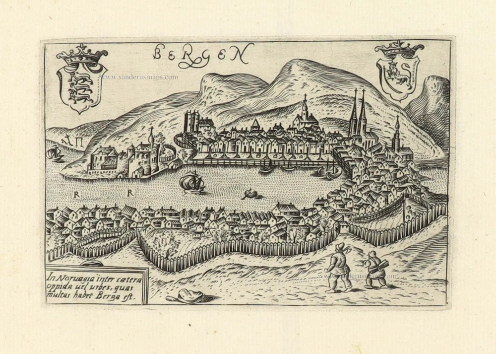
Rare and early view
Bergen. ca. 1580
Bergen (Norway), by Francesco Valegio.
[Item number: 29423]
Regni Norvegiae. 1666
Norway by Joannes Janssonius.
[Item number: 29724]

Das Konigreich Norwegen. 1789
Norway by F. Reilly.
[Item number: 32186]