
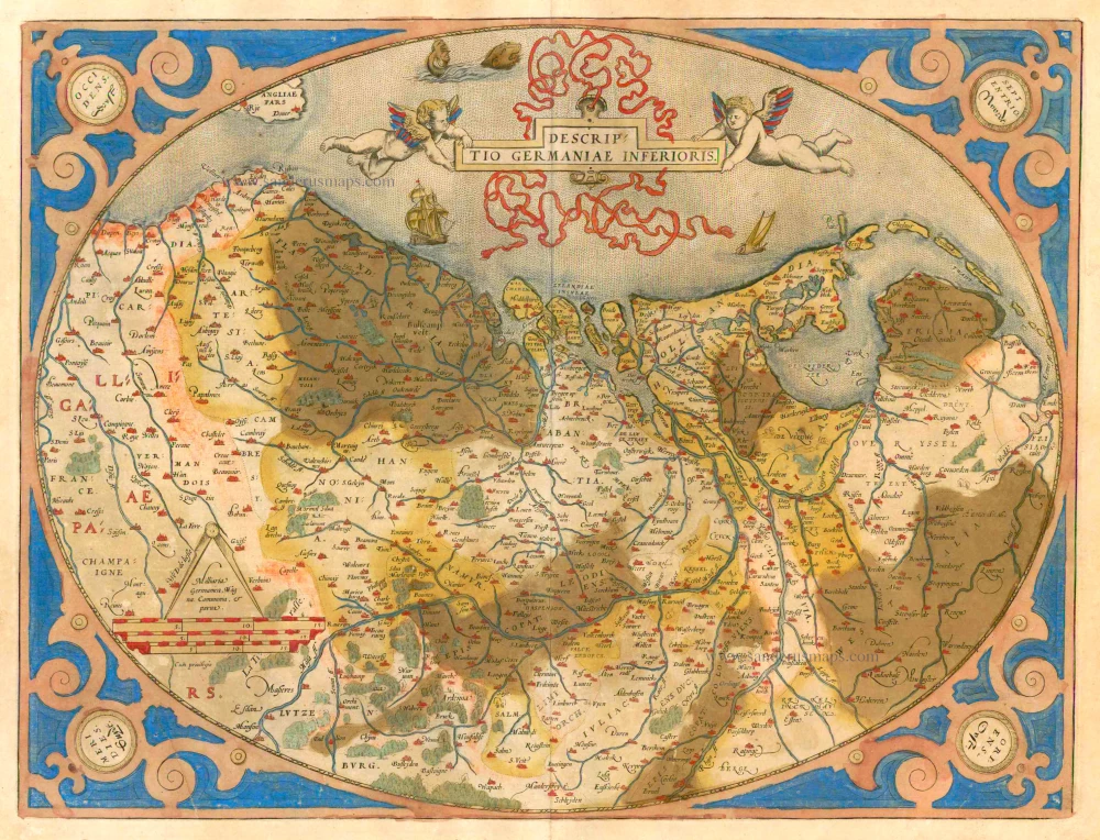
Low Countries by Matthias Quad, published by Johann Bussemacher. 1600

The map is a true copy of Ortelius' map of the Netherlands. Since Albert of Austria became governor of the Netherlands in 1595 and the first state was published in 1596, the map must have been made in one of these years. In his portrait in the second state, Albert, who was secularised in 1598 to enable him to marry Isabella, is no longer depicted as a cardinal.
Matthias Quad (Deventer, 1557 – Eppingen, 1613)
Matthias Quad, born in Deventer in 1557, was trained there as an engraver by the Van Deutecum brothers. He also studied with Hendrick Goltzius in Haarlem. Later, he settled in Germany after spending some time in France and England.
He lived in Cologne since 1587, where he met the renowned engraver and mapmaker Frans Hogenberg and the printer and publisher Johann Bussemacher. For the next 15 years, Quad worked closely with Bussemacher, especially in publishing atlases. In 1592, he published a translation of an atlas by Botero, and in the following years, several geographical works followed.
With Bussemacher, he prepared a hand and travel atlas in a small format, for which he primarily focused on engraving. From 1592, they published some editions under the name of Bussemacher without text. In 1594, the Europae … descriptio appeared as an atlas with 50 maps with text by Quad. Bussemacher printed the maps, but the text was printed by Lambert Andreae, with whom Bussemacher often collaborated. In 1600, the Geographisch Handtbuch, a world atlas featuring 82 maps, was published.
From that time on, Quad released a series of Itineraries. The Deliciae Germaniae (1600), the Deliciae Galliae (1600), the Itinearium universae Germaniae (1602), and others on Northern Europe, Italy and Spain.
He spent the last years of his life as a teacher in Eppingen, where he died in 1613.
Johann Bussemacher (florished 1580-1613)
Johann Bussemacher was a German engraver, publisher, printer and art dealer. Beginning in the 17th century, he was the most successful publisher in Cologne.
Belgium
Item Number: 32421 Authenticity Guarantee
Category: Antique maps > Europe > The Low Countries
Netherlands - 17 Provinces by Matthias Quad, published by Johann Bussemacher.
Title: Belgium
formulis Jani Busse:
Oriented to the west.
Engraver: Matthias Quad.
Date of the first edition: 1595/96.
Date of this map: 1600.
Copper engraving, printed on paper.
Image size: 220 x 305mm (8¾ x 12 inches).
Sheet size: 265 x 335mm (10½ x 13¼ inches).
Verso: German text.
Condition: Hand coloured, excellent.
Condition Rating: A+.
From: Geographisch Handtbuch. Cologne, J. Bussemacher, 1600. (Meurer (Cologne), Qua 6)
The map is a true copy of Ortelius' map of the Netherlands. Since Albert of Austria became governor of the Netherlands in 1595 and the first state was published in 1596, the map must have been made in one of these years. In his portrait in the second state, Albert, who was secularised in 1598 to enable him to marry Isabella, is no longer depicted as a cardinal.
Matthias Quad (Deventer, 1557 – Eppingen, 1613)
Matthias Quad, born in Deventer in 1557, was trained there as an engraver by the Van Deutecum brothers. He also studied with Hendrick Goltzius in Haarlem. Later, he settled in Germany after spending some time in France and England.
He lived in Cologne since 1587, where he met the renowned engraver and mapmaker Frans Hogenberg and the printer and publisher Johann Bussemacher. For the next 15 years, Quad worked closely with Bussemacher, especially in publishing atlases. In 1592, he published a translation of an atlas by Botero, and in the following years, several geographical works followed.
With Bussemacher, he prepared a hand and travel atlas in a small format, for which he primarily focused on engraving. From 1592, they published some editions under the name of Bussemacher without text. In 1594, the Europae … descriptio appeared as an atlas with 50 maps with text by Quad. Bussemacher printed the maps, but the text was printed by Lambert Andreae, with whom Bussemacher often collaborated. In 1600, the Geographisch Handtbuch, a world atlas featuring 82 maps, was published.
From that time on, Quad released a series of Itineraries. The Deliciae Germaniae (1600), the Deliciae Galliae (1600), the Itinearium universae Germaniae (1602), and others on Northern Europe, Italy and Spain.
He spent the last years of his life as a teacher in Eppingen, where he died in 1613.
Johann Bussemacher (florished 1580-1613)
Johann Bussemacher was a German engraver, publisher, printer and art dealer. Beginning in the 17th century, he was the most successful publisher in Cologne.
Related items
First Christoffel Pantin edition
Descriptio Germaniae Inferioris. 1579
XVII Provinces by Abraham Ortelius.
[Item number: 21663]

Belgiae Inferioris descriptio emendata cum circu(m)jacentium regionum confinijs. 1610
The 17 Provinces, by Jan Orlers.
[Item number: 25913]
Belgii sive Germania Inferioris - Nider Teutschlandt. 1638
The 17 Provinces, by Matthäus Merian.
[Item number: 26030]
Belgii sive germaniae inferioris accuratissima tabula. auctore henrico hondio 1631. amstelodami, sumptibus henrici hondio 1631. 1641
The 17 Provinces, by Henricus Hondius.
[Item number: 26301]
Rare
Germania Inferior. Gallia Belgica Dicta, continens Hispaniarum Regis Provincias Septentrionales. 1593
XVII Provinces, by Gerard de Jode.
[Item number: 27943]
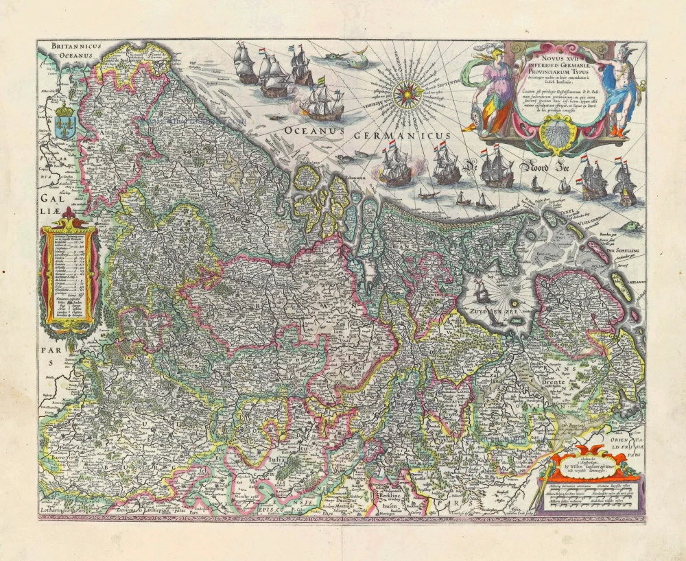
Novus XVII Inferioris Germaniae Provinciarum Typus. 1631
Seventeen Provinces (17 Provinciën), by Willem Blaeu.
[Item number: 28019]
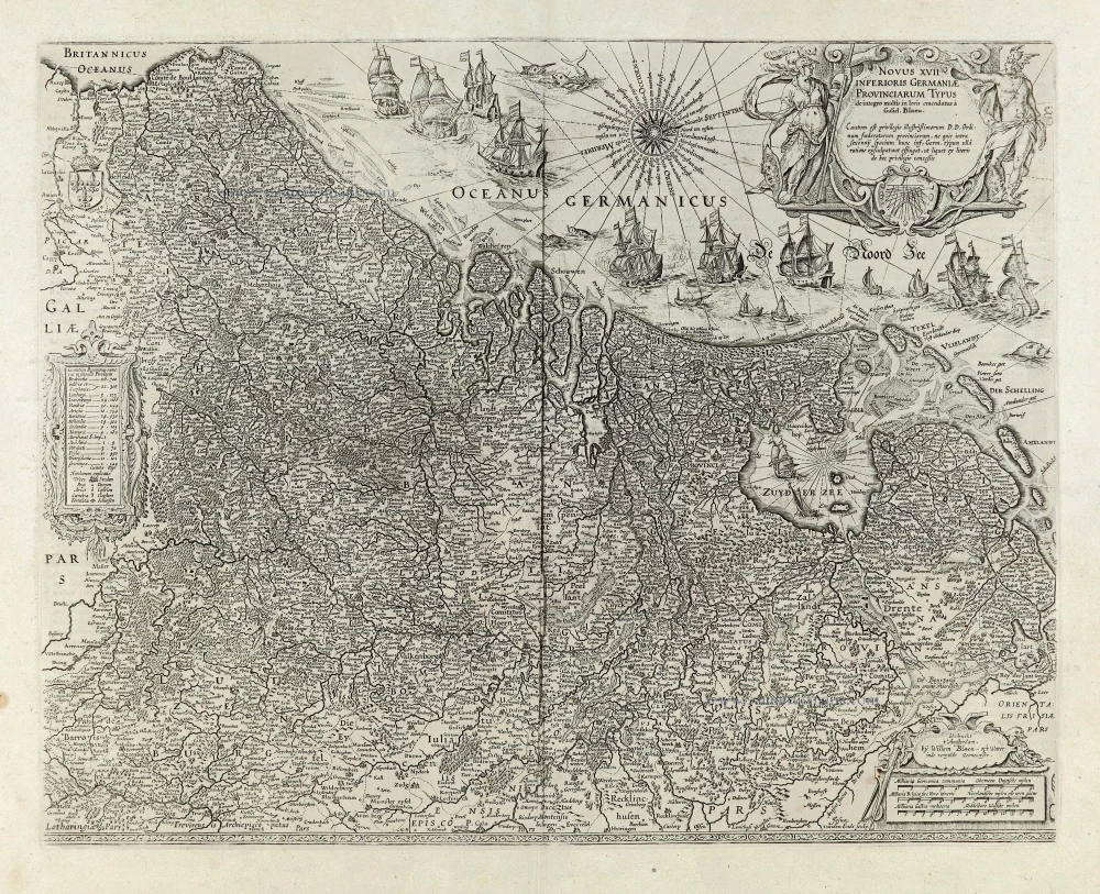
Novus XVII Inferioris Germaniae Provinciarum Typus. 1664-65
Seventeen Provinces (17 Provinciën), by Willem Blaeu.
[Item number: 28110]
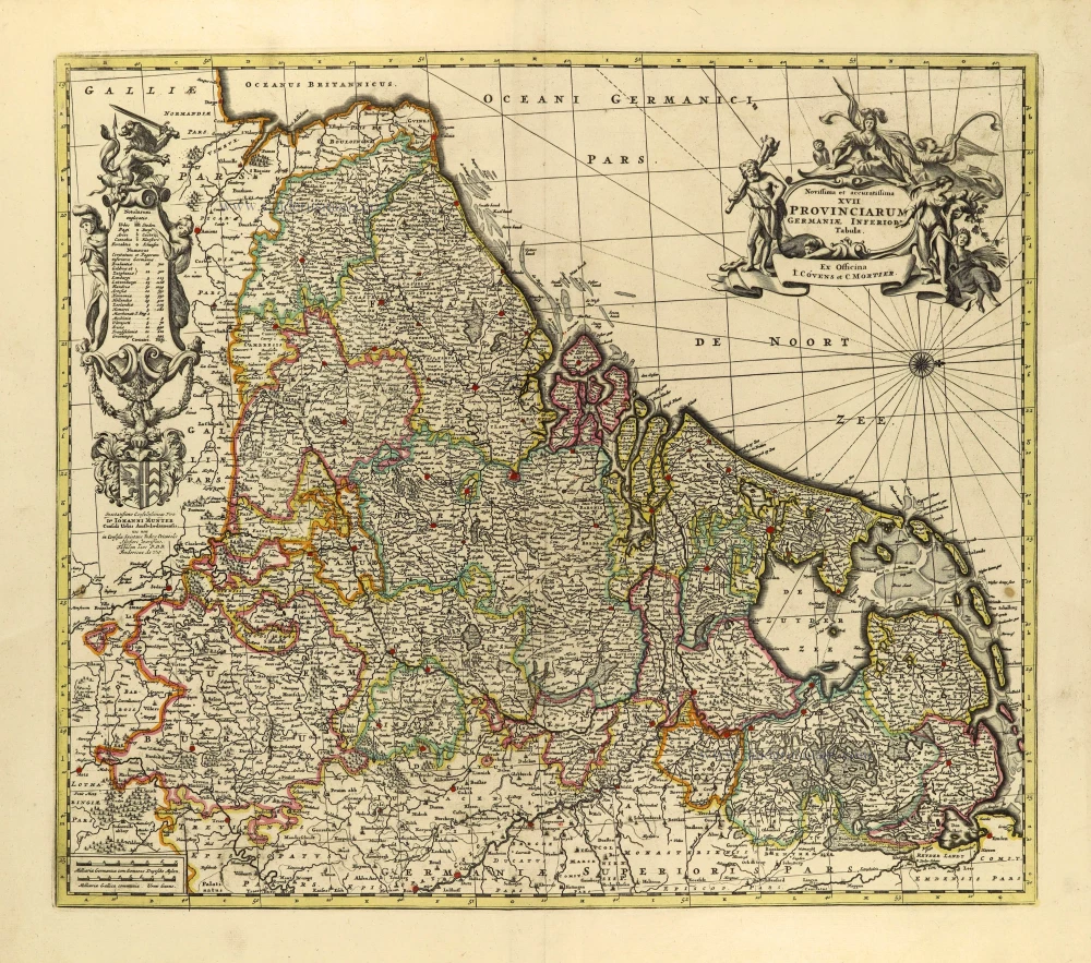
Novissima et accuratissima XVII provinciarum Germaniae Inferioris Tabula. c. 1715
17 Provinces, by Frederik de Wit, published by Covens & Mortier.
[Item number: 28284]

Beautiful original colouring
Descriptio Germaniae Inferioris. 1603
XVII Provinces by Abraham Ortelius.
[Item number: 28899]

Belgium seu Germania Inferior. 1594
The 17 Provinces, by Giovanni Magini.
[Item number: 28914]
In luxury colouring
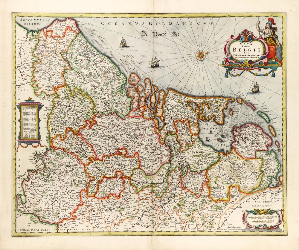
Nova Totius Belgii Sive Germaniae Inferioris. 1666
XVII Provinces (Low Countries) by Joannes Janssonius.
[Item number: 30079]
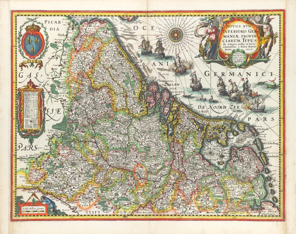
Novus XVII Inferioris Germaniae Provinciarum Typus. 1617
17 Provinces by Petrus Kaerius (Pieter Van den Keere).
[Item number: 30258]

Inferior Germania 1618
XVII Provinces by Petrus Bertius, published by Jodocus Hondius II.
[Item number: 31580]
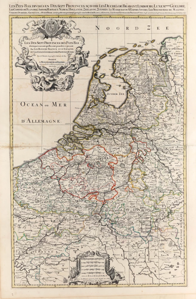
Les dix sept provinces des Pays Bas distinguées suivant qu'elles sont possedées a present par les Roys de France et d'Espagne et les Estats Generaux des Provinces Unies. 1692
XVII Provinces by N. Sanson, so-called published by Hubert Jaillot. (Pirated edition by Pierre Mortier).
[Item number: 31719]

Rare first state
Tabula Generalis Totius Belgii qua Provinciae XVII. Infer. Germaniae olim sub S.R.I. Circulo Burgundiae comprehensae ... 1711-1713
17 Provinces, by J.B. Homann.
[Item number: 32464]

Belgii Universi seu Inferioris Germaniae quam XVII Provinciae, Austriaco, Gallico et Batavo Sceptro parentes constituunt, 1752
XVII Provinces by Johan Tobias Mayer, published by Homann Heirs
[Item number: 32687]
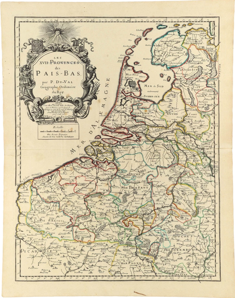
Les XVII. Provinces des Pays-Bas. 1688
17 Provinces by P. Duval.
[Item number: 32902]
new