
First Christoffel Pantin edition
XVII Provinces by Abraham Ortelius. 1579


Abraham Ortelius (1527-1598)
The maker of the 'first atlas', the Theatrum Orbis Terrarum (1570), was born on 4 April 1527 into an old Antwerp family. He learned Latin and studied Greek and mathematics.
Abraham and his sisters, Anne and Elizabeth, took up map colouring. Ortelius was admitted to the Guild of St. Luke as an "illuminator of maps." In addition to colouring maps, Ortelius was a dealer in antiques, coins, maps, and books, and the book and map trade gradually became his primary occupation.
Business went well because his means allowed him to amass an extensive collection of medals, coins, and antiques, as well as a library of many volumes. In addition, he travelled extensively, visited Italy and France, made contacts with scholars and editors everywhere, and maintained extensive correspondence with them.
In 1564, he published his first map, a large and ambitious world wall map. The inspiration for this map may well have been Gastaldi's large world map. In 1565, he published a map of Egypt and a map of the Holy Land; a large map of Asia followed.
In 1568, the production of individual maps for his atlas Theatrum Orbis Terrarum was already in full swing. He completed the atlas in 1569, and in May 1570, it was available for sale. It was one of the most expensive books ever published.
This first edition contained seventy maps on fifty-three sheets. Franciscus Hogenberg engraved the maps.
Later editions included Additamenta (additions), resulting in Ortelius' historical atlas, the Parergon, which is mainly bound together with the atlas. The Parergon can be considered a truly original work by Ortelius, who drew the maps based on his research.
The importance of the Theatrum Orbis Terrarum for geographical knowledge in the last quarter of the sixteenth century is difficult to overemphasise. Nothing was like it until Mercator's atlas appeared twenty-five years later. Demand for the Theatrum was remarkable. Some 24 editions appeared during Ortelius's lifetime, and another 10 after he died in 1598. Editions were published in Dutch, German, French, Spanish, English, and Italian. The number of map sheets grew from 53 in 1570 to 167 in the last edition in 1612.
In 1577, engraver Philip Galle and poet-translator Pieter Heyns published the first pocket-sized edition of the Theatrum, the Epitome. The work was trendy. Over thirty editions of this Epitome were published in different languages.
Ortelius is also remembered for an early idea resembling continental drift: he suggested that the Americas, Europe, and Africa may once have been joined together before separating over time. His work helped shape the development of modern geography and mapmaking.
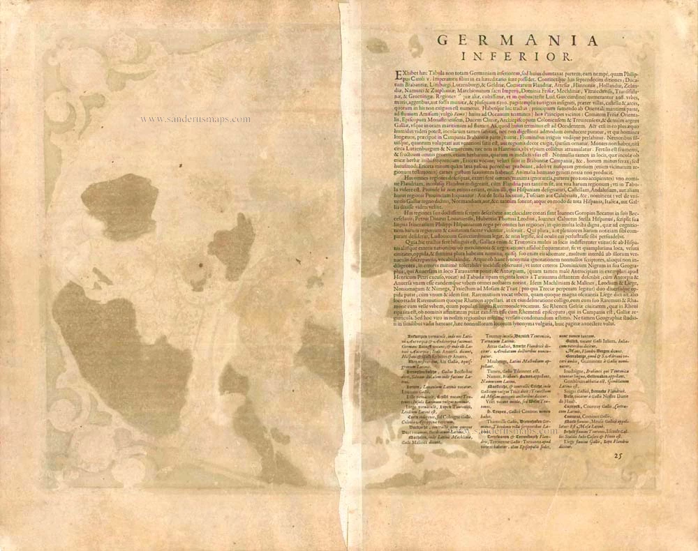
Descriptio Germaniae Inferioris.
Item Number: 21663 Authenticity Guarantee
Category: Antique maps > Europe > The Low Countries
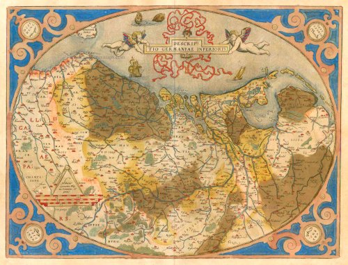
Old, antique map of the XVII Provinces by Abraham Ortelius.
Title: Descriptio Germaniae Inferioris.
Date of the first edition: 1570.
Date of this map: 1579.
Copper engraving, printed on paper.
Size (not including margins): 383 x 502mm (15.08 x 19.76 inches).
Verso: Latin text.
Condition: Original coloured, verdigris area reinforced at the back.
Condition Rating: B.
From: Theatrum Orbis Terrarum. Antwerp, Chr. Plantin, 1579. (Van der Krogt 3, 31:021A (First printing of two)) First Plantin edition.
Abraham Ortelius (1527-1598)
The maker of the 'first atlas', the Theatrum Orbis Terrarum (1570), was born on 4 April 1527 into an old Antwerp family. He learned Latin and studied Greek and mathematics.
Abraham and his sisters, Anne and Elizabeth, took up map colouring. Ortelius was admitted to the Guild of St. Luke as an "illuminator of maps." In addition to colouring maps, Ortelius was a dealer in antiques, coins, maps, and books, and the book and map trade gradually became his primary occupation.
Business went well because his means allowed him to amass an extensive collection of medals, coins, and antiques, as well as a library of many volumes. In addition, he travelled extensively, visited Italy and France, made contacts with scholars and editors everywhere, and maintained extensive correspondence with them.
In 1564, he published his first map, a large and ambitious world wall map. The inspiration for this map may well have been Gastaldi's large world map. In 1565, he published a map of Egypt and a map of the Holy Land; a large map of Asia followed.
In 1568, the production of individual maps for his atlas Theatrum Orbis Terrarum was already in full swing. He completed the atlas in 1569, and in May 1570, it was available for sale. It was one of the most expensive books ever published.
This first edition contained seventy maps on fifty-three sheets. Franciscus Hogenberg engraved the maps.
Later editions included Additamenta (additions), resulting in Ortelius' historical atlas, the Parergon, which is mainly bound together with the atlas. The Parergon can be considered a truly original work by Ortelius, who drew the maps based on his research.
The importance of the Theatrum Orbis Terrarum for geographical knowledge in the last quarter of the sixteenth century is difficult to overemphasise. Nothing was like it until Mercator's atlas appeared twenty-five years later. Demand for the Theatrum was remarkable. Some 24 editions appeared during Ortelius's lifetime, and another 10 after he died in 1598. Editions were published in Dutch, German, French, Spanish, English, and Italian. The number of map sheets grew from 53 in 1570 to 167 in the last edition in 1612.
In 1577, engraver Philip Galle and poet-translator Pieter Heyns published the first pocket-sized edition of the Theatrum, the Epitome. The work was trendy. Over thirty editions of this Epitome were published in different languages.
Ortelius is also remembered for an early idea resembling continental drift: he suggested that the Americas, Europe, and Africa may once have been joined together before separating over time. His work helped shape the development of modern geography and mapmaking.
Related items

Belgii Veteris Typus. 1601
The ancient Low Countries, by Abraham Ortelius.
[Item number: 12355]

Frisia Occidentalis 1598
West Friesland, by Abraham Ortelius.
[Item number: 22913]

Belgiae Inferioris descriptio emendata cum circu(m)jacentium regionum confinijs. 1610
The 17 Provinces, by Jan Orlers.
[Item number: 25913]

Rare
Germania Inferior. Gallia Belgica Dicta, continens Hispaniarum Regis Provincias Septentrionales. 1593
XVII Provinces, by Gerard de Jode.
[Item number: 27943]

Belgium sive Inferior Germania. 1630
XVII Provinces, by A. Goos - J. Janssonius.
[Item number: 27988]

Novissima et accuratissima XVII provinciarum Germaniae Inferioris Tabula. After 1721
17 Provinces, by Frederik de Wit, published by Covens & Mortier.
[Item number: 28284]

In luxury colouring
Nova Totius Belgii Sive Germaniae Inferioris. 1666
XVII Provinces (Low Countries) by Joannes Janssonius.
[Item number: 30079]

Inferior Germania 1618
XVII Provinces by Petrus Bertius, published by Jodocus Hondius II.
[Item number: 31580]

Les dix sept provinces des Pays Bas distinguées suivant qu'elles sont possedées a present par les Roys de France et d'Espagne et les Estats Generaux des Provinces Unies. 1692
XVII Provinces by N. Sanson, so-called published by Hubert Jaillot. (Pirated edition by Pierre Mortier).
[Item number: 31719]

Belgium 1600
Low Countries by Matthias Quad, published by Johann Bussemacher.
[Item number: 32421]

Richly heightened in gold
Novissima et accuratissima XVII provinciarum Germaniae Inferioris Tabula. c. 1675
17 Provinces, by Frederik de Wit.
[Item number: 33063]
new