
Luxury colouring!
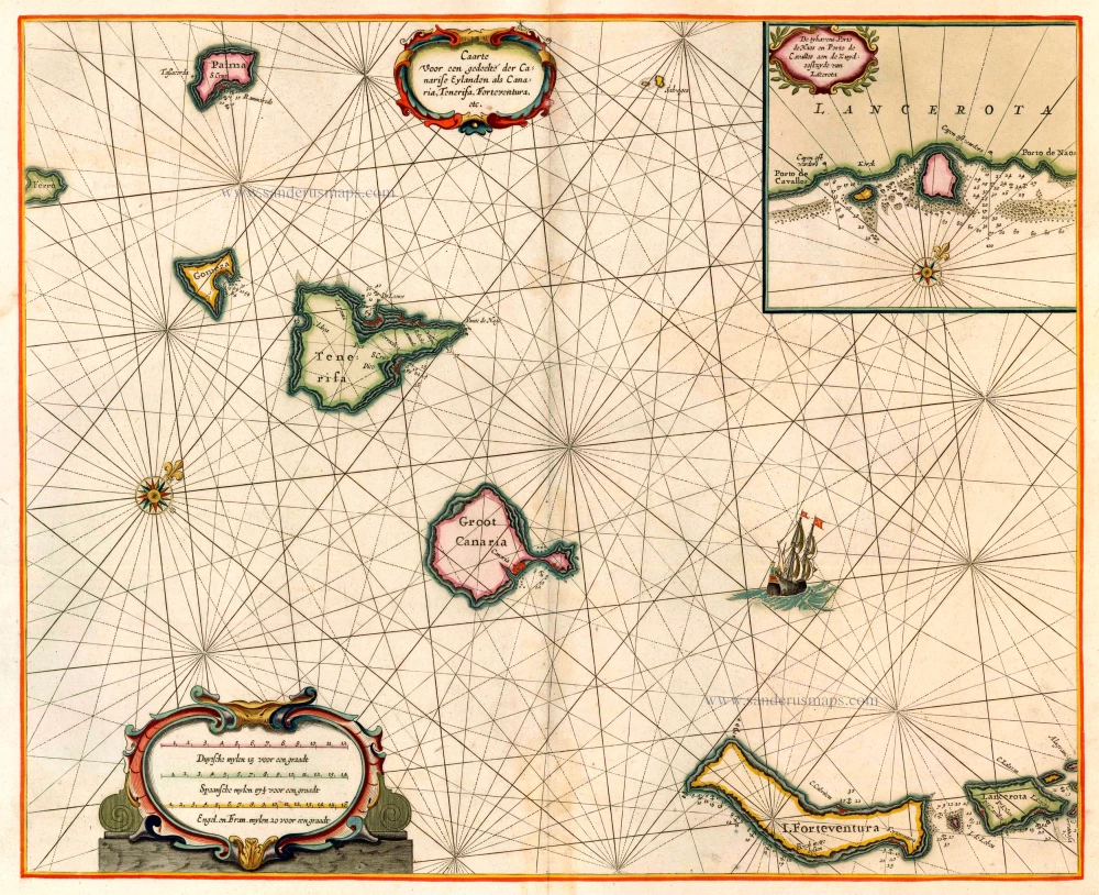
The Canary Islands, by Pieter Goos. 1666
"Pieter Goos' marine atlases were held to be among the finest printed at the time and were often added tot the nine or twelve volumes of Blaeu's Atlas Maior." (Shirley)
Pieter Goos (1615-1675)
Pieter Goos, son of the engraver Abraham Goos, was one of the best known maritime booksellers of Amsterdam. He was not only a bookseller but also a copper-engraver and even a book printer.
His first pilot book, the Lichtende Columne ofte Zee-Spiegel appeared in 1650. The well-made pilot guides and the beautiful sea-atlas reflect a high professional standard. The many editions published over 28 years is an indication of the customers’ appreciation. The Zeespiegel was printed in Dutch, French (1662), and English (1658). Goos printed all the time from the same 60 plates. For his Straetsboeck, being the third part of the Zeespiegel, Pieter Goos copied the text from Lootsman’s Straetboeck and copied also the plates. This atlas of the Mediterranean appeared in 1662.
Pieter Goos also published a fourth and fifth part of his Zeespiegel. For the fourth part, he used the second part of Het Brandende Veen by Arent Roggeveen, which dealt with the coasts of West-Africa (No copy with Goos’s imprint is known). For the fifth part, he used the first part of Het Brandende Veen, which appeared in 1675. It contains the charts and sailing directions for the West Indies.
The first edition of his sea-atlas, the Zee-Atlas ofte Water-Wereld, came out in 1666. For the design of the charts, Goos copied nearly all the charts from Hendrik Doncker’s sea-atlas. All the years through, till 1675 (the year of his death), the number of 40 or 41 maps remained the same.
When Pieter Goos died in March 1675, his widow continued the shop. She brought out a few new editions of the Zee-Atlas with 44 charts. Part of the atlases was sold then by the famous Amsterdam bookbinder Albert Magnus. These copies are renowned for their outstanding colouring. She died in 1677; their son, Hendrik Goos, born in 1641, took over and sold his father’s pilot books until 1680.
Caarte voor en Gedeelte der Canarise Eylanden als Canaria, Tenerifa, Forteventura, etc.
Item Number: 25612 Authenticity Guarantee
Category: Antique maps > Oceans
Old, antique map of the Canary Islands by Goos P., oriented to the Northwest
Date of the first edition: 1666
Date of this map: 1666
Copper engraving
Size (not including margins): 42.5 x 52.5cm (16.6 x 20.5 inches)
Verso: Blank
Condition: Superb original colouring, heightened in gold, on heavy paper.
Condition Rating: A+
References: Koeman, Goos1B (22).
From: De Zee-Atlas, Ofte Water-Weereld, Waer in vertoont werden alle de Zee-Kusten Van het bekende des Aerd-Bodems. P. Goos, 1666. (Koeman, Goos1B)
Framed.
"Pieter Goos' marine atlases were held to be among the finest printed at the time and were often added tot the nine or twelve volumes of Blaeu's Atlas Maior." (Shirley)
"Pieter Goos' marine atlases were held to be among the finest printed at the time and were often added tot the nine or twelve volumes of Blaeu's Atlas Maior." (Shirley)
Pieter Goos (1615-1675)
Pieter Goos, son of the engraver Abraham Goos, was one of the best known maritime booksellers of Amsterdam. He was not only a bookseller but also a copper-engraver and even a book printer.
His first pilot book, the Lichtende Columne ofte Zee-Spiegel appeared in 1650. The well-made pilot guides and the beautiful sea-atlas reflect a high professional standard. The many editions published over 28 years is an indication of the customers’ appreciation. The Zeespiegel was printed in Dutch, French (1662), and English (1658). Goos printed all the time from the same 60 plates. For his Straetsboeck, being the third part of the Zeespiegel, Pieter Goos copied the text from Lootsman’s Straetboeck and copied also the plates. This atlas of the Mediterranean appeared in 1662.
Pieter Goos also published a fourth and fifth part of his Zeespiegel. For the fourth part, he used the second part of Het Brandende Veen by Arent Roggeveen, which dealt with the coasts of West-Africa (No copy with Goos’s imprint is known). For the fifth part, he used the first part of Het Brandende Veen, which appeared in 1675. It contains the charts and sailing directions for the West Indies.
The first edition of his sea-atlas, the Zee-Atlas ofte Water-Wereld, came out in 1666. For the design of the charts, Goos copied nearly all the charts from Hendrik Doncker’s sea-atlas. All the years through, till 1675 (the year of his death), the number of 40 or 41 maps remained the same.
When Pieter Goos died in March 1675, his widow continued the shop. She brought out a few new editions of the Zee-Atlas with 44 charts. Part of the atlases was sold then by the famous Amsterdam bookbinder Albert Magnus. These copies are renowned for their outstanding colouring. She died in 1677; their son, Hendrik Goos, born in 1641, took over and sold his father’s pilot books until 1680.
Related items

Ocean Atlantique et Mers Adjacentes en Quatre Feuilles Contenant les Cotes de l'Europe, de l'Afrique et de l'Amerique ... 1778
The Atlantic Ocean, by G.L. Le Rouge.
[Item number: 14086]
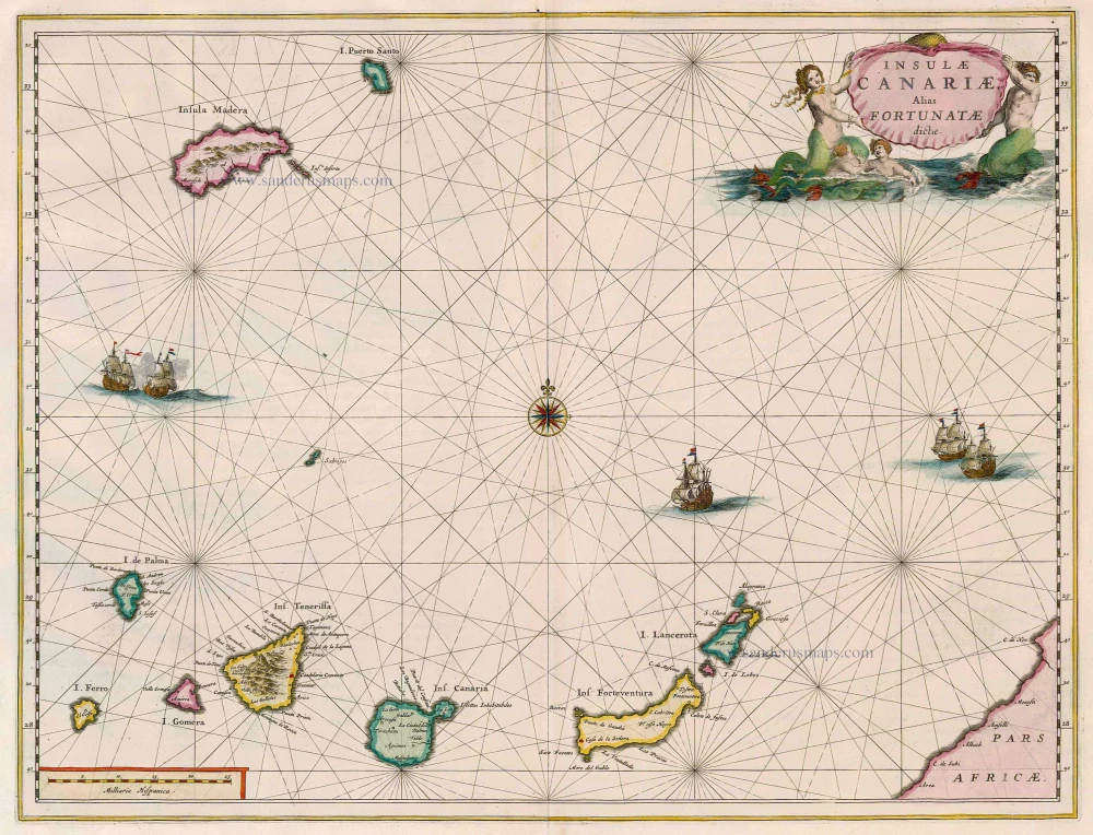
Insulae Canariae alias Fortunatae Dictae 1664-65
Canary Islands, by Joan Blaeu.
[Item number: 14157]
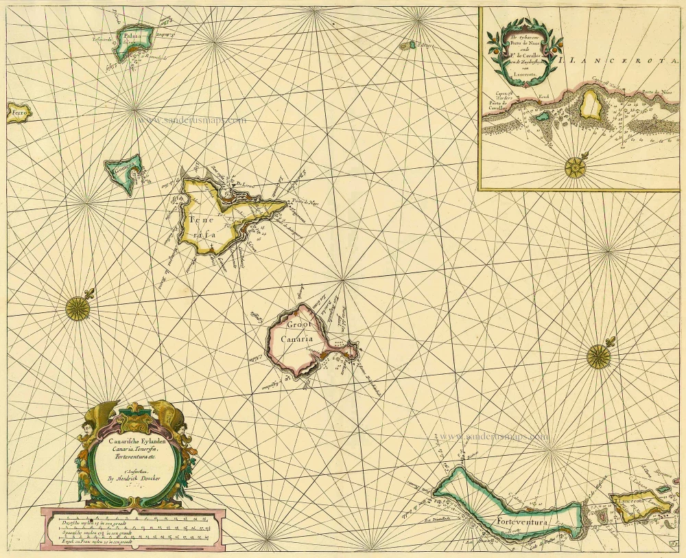
Canarische Eylanden Canaria Tenerifa, Forteventura etc. t' Amsterdam, 1686
Canary Islands, by Hendrick Doncker.
[Item number: 15419]
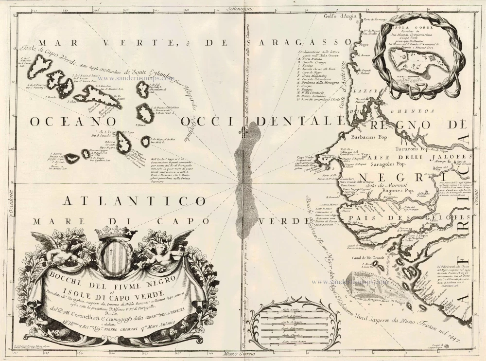
Bocche del Fiume Negro et Isole di Capo Verde 1691
Cape Verde Islands, by Coronelli V.M.
[Item number: 23167]
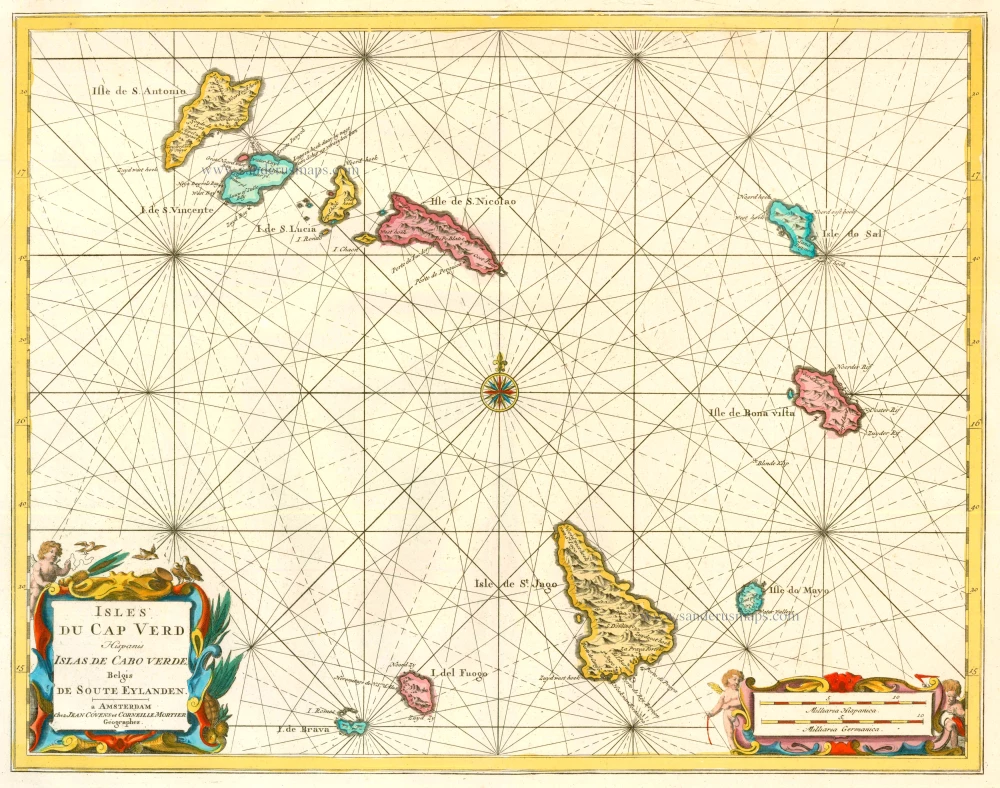
Isles du Cap Verd Hispanis Islas de Cabo Verde Belgis de Soute Eylanden. 1721-41
Cape Verde Islands, by Covens & Mortier.
[Item number: 23621]
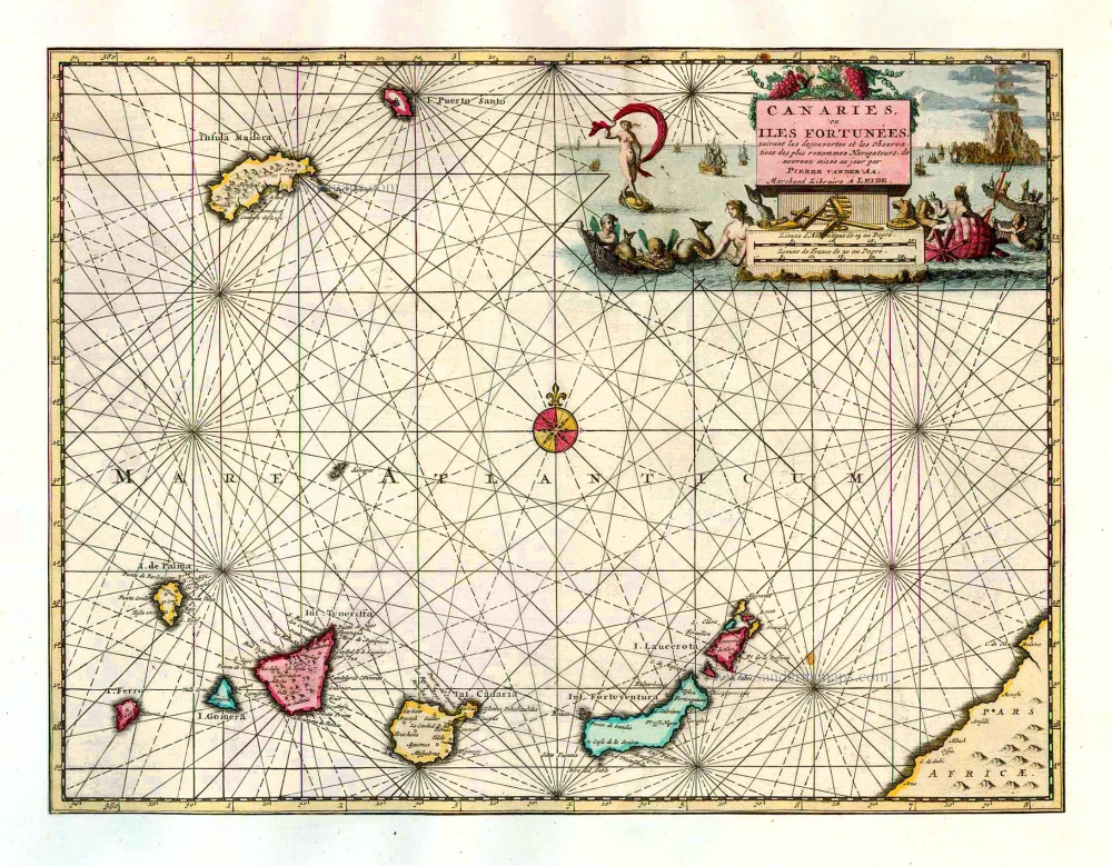
Canaries, ou Iles Fortunées. 1713
Canary Islands by Pieter van der Aa.
[Item number: 26163]
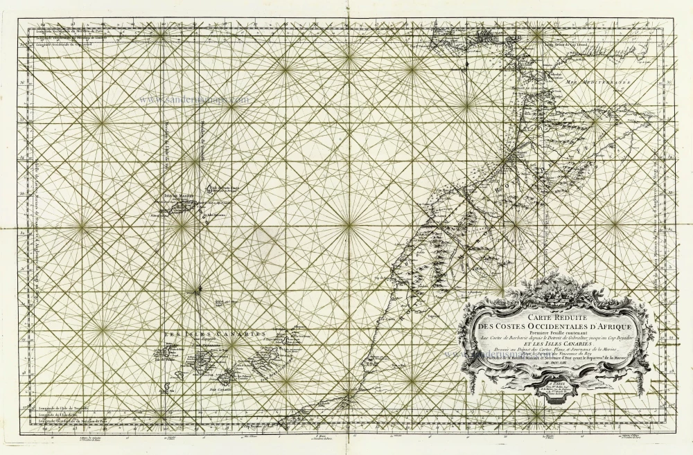
Carte Reduite des Costes Occidentales d'Afrique ... et les Isles Canaries. 1756-1770
Canary Islands - West Africa, by J.N. Bellin.
[Item number: 28116]
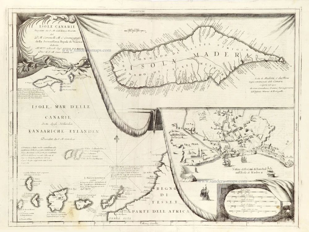
Isole Canarie / Isola di Madero / Veduta della Citta di Fanchal. 1696
Three maps on one sheet: Isole Canarie and two curtained inset maps: Isole Madera, and Veduta della Citta di Fanchal.
[Item number: 28929]