
America - Atlantic Ocean by Martin Waldseemüller 1513
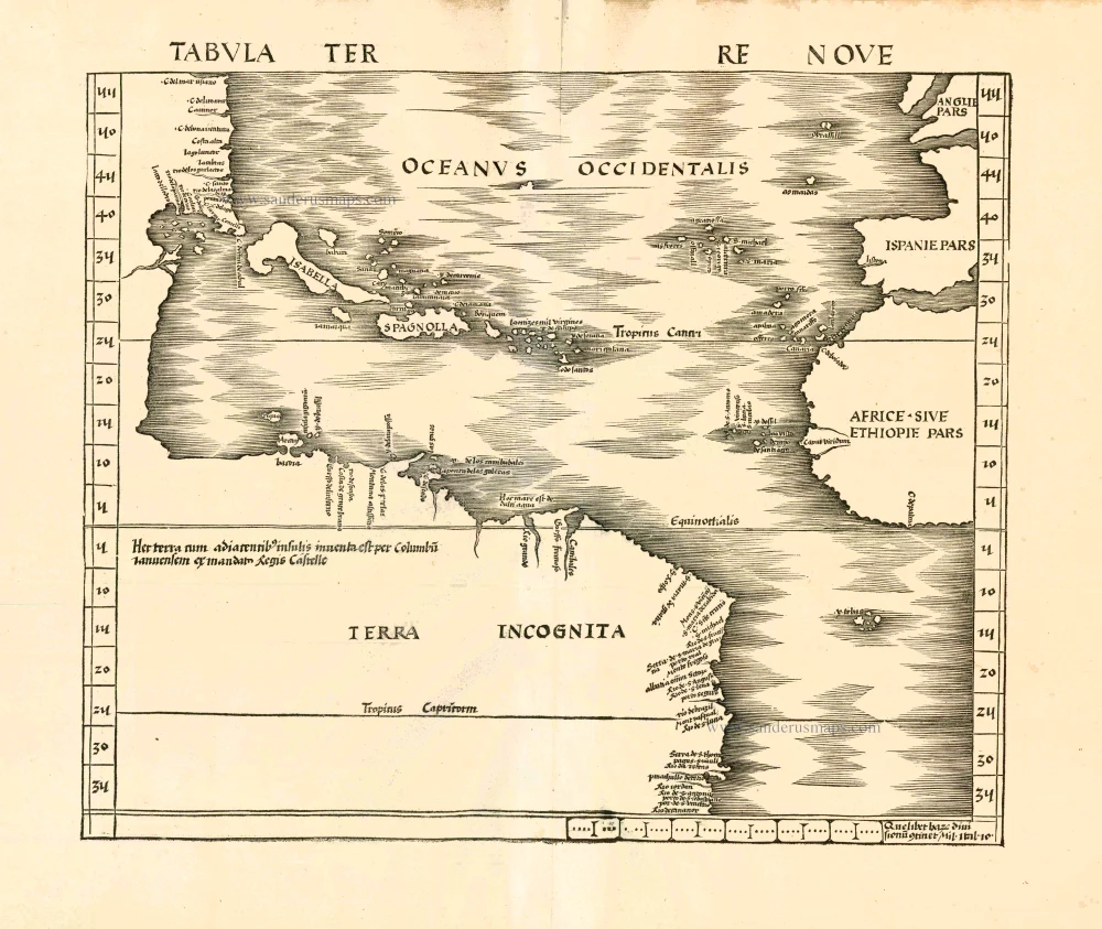
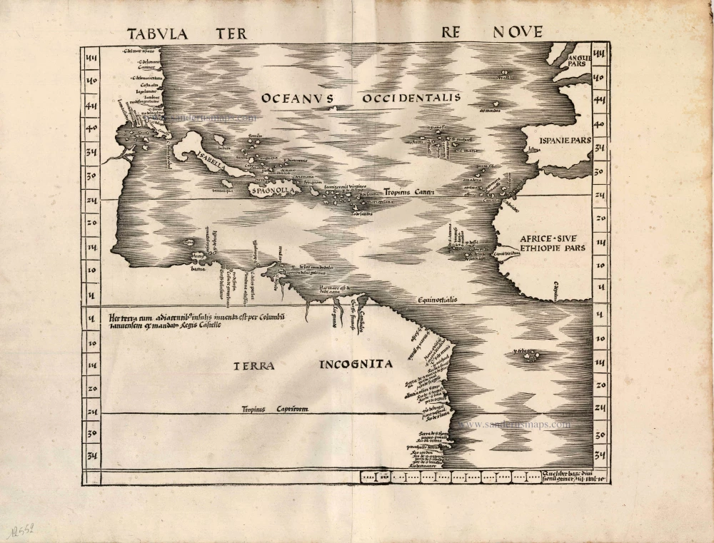

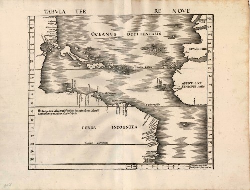

This important map is the first devoted to America to appear in an atlas. Twenty place names are shown on the North American coastline, largely from Portuguese sources, most notably the Cantino portolan chart of 1502 and the Caveri of c.1505. What appears to be the Gulf of Mexico illustrates possible knowledge of an unrecorded voyage before that of Alonzo Alvarez de Pineda in 1519. Similarly, the Florida peninsula is shown before recorded knowledge of it could have reached Europe. Cuba is here named Isabella after the queen of Spain and positioned further north than is actually the case.
In 1507 Waldseemüller produced the twelve sheet world map in which he named the new continent America after Amerigo Vespucci, incorrectly thinking that he was its discoverer. At this time documentation shows that he was already working on an edition of Ptolemy's Geography and that some of the modern maps had already been prepared, the America is not believed to be one of them. In the South American continent is shown an inscription 'Hex terra cum adiacentib insulis inuenta est per Columbu ianuensem ex mandato Regis Castelle' (this land with its adjacent islands was discovered by Columbus, sent by authority of the King of Castile). There is no mention of America on the map, Waldseemüller was trying to correct his error but it proved to be futile. This 1513 map could not have been prepared much before 1508, the year after he produced the wall map. The cause of the delay in publication is unknown but it is speculated that there were financial reasons and printing problems due to the physical size of the work.
In the introduction to the atlas Waldseemüller refers to 'the Admiral' as the source of information for the New World cartography. It is generally assumed that he is referring to Columbus, and hence the label 'The Admiral's map' is often applied to either the modern world map or to this one. (Burden)
Tabula Terre Nove.
Item Number: 12552 Authenticity Guarantee
Category: Antique maps > Oceans
Old, antique map of America - Atlantic Ocean by Martin Waldseemüller.
Date of the first edition: 1513
Date of this map: 1513
Woodcut
Size: 46 x 60cm (17.9 x 23.4 inches)
Verso: Blank
Condition: Printed on thick paper, several filled wormholes, else excellent.
Condition Rating: B
References: Burden, 3; Karrow, 80/33; Suarez (Veil), 9; Schwartz & Ehrenberg, pp.31-34.
From: Claudii Ptolemei viri Alexandrini Mathematice discipline Philosophi dictissimi Geographiae opus novissima . . . Strassburg, J. Schott, 1513.
The Strassbourg Ptolemy is the most important edition of the Geographia. Preparatory work was begun in about 1505 by Martin Waldseemüller, scholar-geographer of the small town of St. Dié in Lorraine, together with his associate Mathias Ringmann. Waldseemüller is believed to have incised many of the maps himself; all are firm distinctive woodcuts. By 1507 much progress had been made but the project was delayed and was not completed until 1513 under the editorship of Jacob Eszler and Georg Ubelin. The printer was Johann Schott, and the work, the first modern atlas, bears a dedication to the Emperor Maximilian.
This important map is the first devoted to America to appear in an atlas. Twenty place names are shown on the North American coastline, largely from Portuguese sources, most notably the Cantino portolan chart of 1502 and the Caveri of c.1505. What appears to be the Gulf of Mexico illustrates possible knowledge of an unrecorded voyage before that of Alonzo Alvarez de Pineda in 1519. Similarly, the Florida peninsula is shown before recorded knowledge of it could have reached Europe. Cuba is here named Isabella after the queen of Spain and positioned further north than is actually the case.
In 1507 Waldseemüller produced the twelve sheet world map in which he named the new continent America after Amerigo Vespucci, incorrectly thinking that he was its discoverer. At this time documentation shows that he was already working on an edition of Ptolemy's Geography and that some of the modern maps had already been prepared, the America is not believed to be one of them. In the South American continent is shown an inscription 'Hex terra cum adiacentib insulis inuenta est per Columbu ianuensem ex mandato Regis Castelle' (this land with its adjacent islands was discovered by Columbus, sent by authority of the King of Castile). There is no mention of America on the map, Waldseemüller was trying to correct his error but it proved to be futile. This 1513 map could not have been prepared much before 1508, the year after he produced the wall map. The cause of the delay in publication is unknown but it is speculated that there were financial reasons and printing problems due to the physical size of the work.
In the introduction to the atlas Waldseemüller refers to 'the Admiral' as the source of information for the New World cartography. It is generally assumed that he is referring to Columbus, and hence the label 'The Admiral's map' is often applied to either the modern world map or to this one. (Burden)
Related items
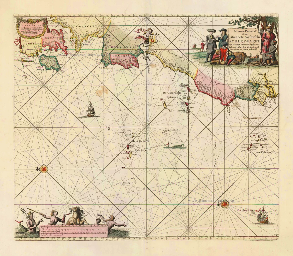
Nieuwe Paskaert vande Gheheele Westersche Scheep-Vaert, op Nieus uyt Ondervindinghe van Schrandre Stierlieden Naaukeurigh Geteeckent en Samen Gebracht. 1697-1709
The Atlantic Ocean, by J. Van Keulen.
[Item number: 11218]

Ocean Atlantique et Mers Adjacentes en Quatre Feuilles Contenant les Cotes de l'Europe, de l'Afrique et de l'Amerique ... 1778
The Atlantic Ocean, by G.L. Le Rouge.
[Item number: 14086]

Paskaart van de Cust van Portugal, Barbaria, en Genehoa Beginnende van d'Barlengers tot aan C. Verde. 1680-1694
Sea chart of the northwest coast of Africa, with the Azores, Canary Islands and Cape Verde Islands, by Johannes Van Keulen.
[Item number: 26808]
Rare.
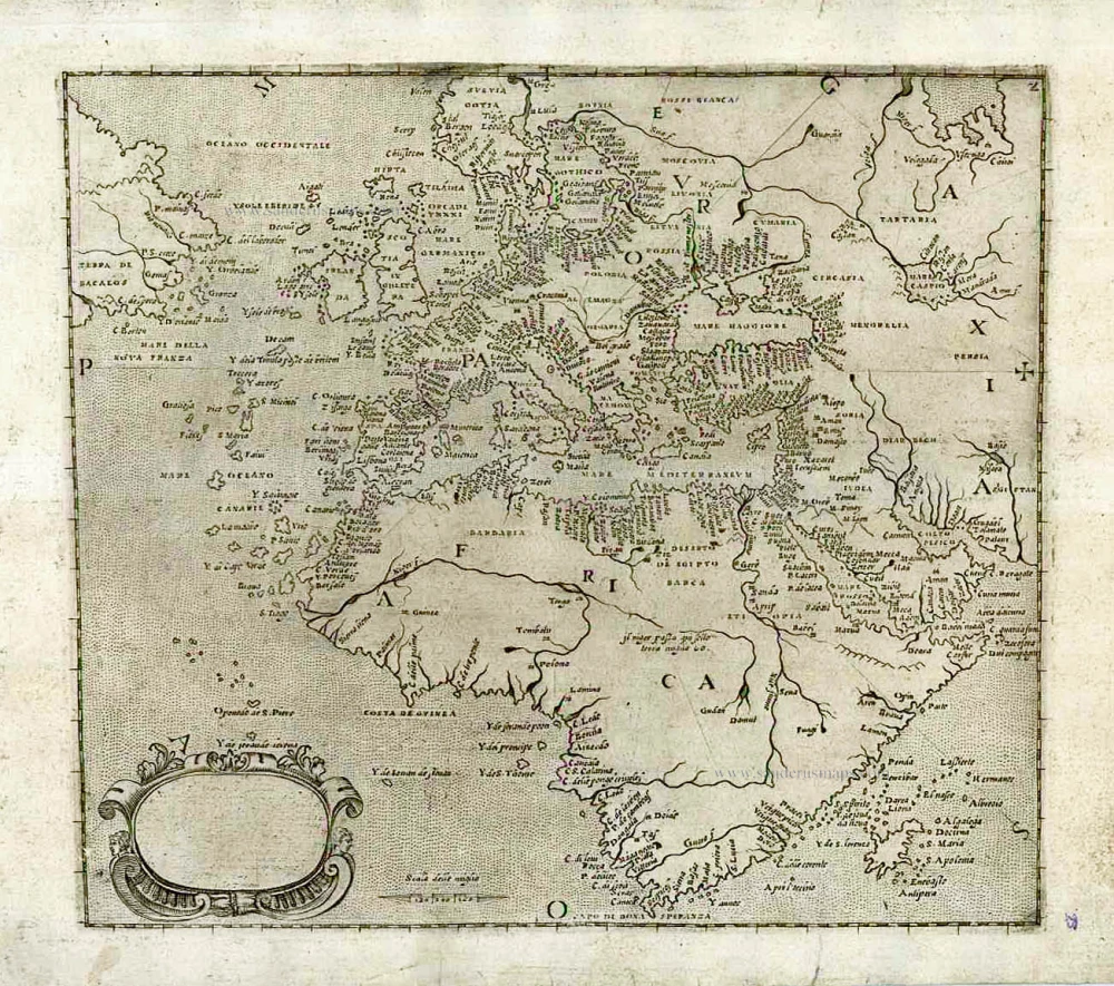
[No title] c. 1575
Atlantic Ocean - Europe, Africa & Eastern Canada by Giovanni Francesco Camocio
[Item number: 27086]