
America by Sebastian Münster. 1550
The item displayed on this page has been sold. However, we have a similar map in stock:
America by Sebastian Münster. 1555
Le table des neufues lesquelles on appelle isles ...
[Item number: 30379]
new

In 1540 Sebastian Münster, one of the most influential cartographers of the sixteenth century published his edition of Ptolemy's Geography with a different section of modern, more up-to-date maps. For the first time, he included a set of continental maps; America was the earliest of any note. The map's inclusion in Münsters Cosmography, first published in 1544, sealed the fate of "America" as the name for the New World. The Portuguese flag is shown flying over the South Atlantic, and the Spanish one over her possessions in the Caribbean. The Strait of Magellan is named again, and Mare pacificum appears for the first time on a printed map. Magellan's ship Victoria, the only survivor of five vessels, appears in the middle of this ocean. Marco Polo's influence can be seen with Zipangri (Japan), appearing three years before the earliest known contact with Europeans and his Archipelagus 7448 insularu. The Yucatan is still shown as an island, and the lake at Temistitan is depicted emptying into the Gulf of Mexico. North America is not shown as accurately as the southern half of the continent; it had, to a large extent, been neglected so far by explorers. When Giovanni di Verrazzano, in the service of Francis I of France, passed by the Outer Banks of the Carolinas in 1524, he mistook Pamlico and Albemarle Sounds for the 'Oriental Sea' that led to Cathay and the rich Spice Islands. Here Münster perpetuated this error and provided a considerable impetus to exploring the region through the success of this book. The only place names occurring here are C. Britonum, marking England's early explorations, Corterati, probably Newfoundland after the Corte Reals, and Terra Florida. FRANCISCA is named in honour of Francis I. (Burden)
Sebastian Münster (1488-1552)
Sebastian Münster, a German geographer, cartographer, Hebraist, and theologian, was born in Ingelheim, near Mainz In 1505, he went to Heidelberg to enter the Franciscan order. In 1507 he went to Louvain, where he studied mathematics, geography, and astronomy. In 1509 Münster became a student of Konrad Pelikan, who taught Hebrew and Greek as well as mathematics and cosmography. In 1518 he completed his studies at the University of Tübingen. He was the favorite of the famous mathematician and astronomer Johann Stöffler.
In 1524 Münster was appointed professor of Hebrew at Heidelberg University. In 1525 he published his first map as part of a broadside: The Instrument of the Suns combined a map, calendar, astrological almanac, sundial, and nocturnal on one attractive sheet, suitable for wall mounting.
In 1540 he published a Latin edition of Ptolemy's Geographia with illustrations. He based this edition on the Latin translation by Willibald Pirkheimer and produced new maps to supplement the Ptolemaic maps. The twenty-seven maps of the Ptolemaic canon are supplemented by twenty-one new maps. Further editions appeared in 1541 and 1542.
In 1544 he published the Cosmographia, a bulky book with 659 pages and some 520 woodcuts. Maps in this edition included three maps from the Ptolemaic canon and fourteen modern maps (from previous editions of the Geographia), as well as nine new maps. Later editions (1545, 1546, 1548) enlarged the Cosmographia. The 1550 edition contains cities, portraits, and costumes. These editions in both Latin and German constitute the full fruition of Münster's dream of a comprehensive geography.
The Cosmographia was one of the most successful works of the 16th century. It passed through 24 editions in 100 years, in different languages, including Latin, French, Italian, English, and even Czech. The last German edition was published in 1628.
He died at Basel of the plague in 1552.
As a cartographer, Münster deserves special recognition for formulating a plan for a comprehensive and uniform map of a country. As a geographer, his greatest achievement was the Cosmographia. (Karrow).
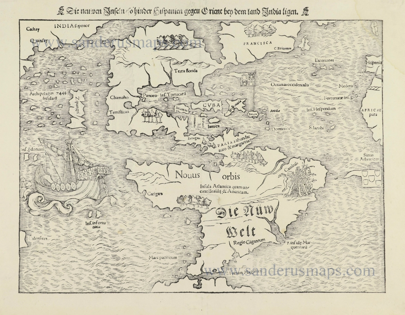
Die Neüwen Inseln / so hinder Hispanien gegeu Orient / bey dem Landt India ligen.
Item Number: 28519 Authenticity Guarantee
Category: Antique maps > America > The Americas
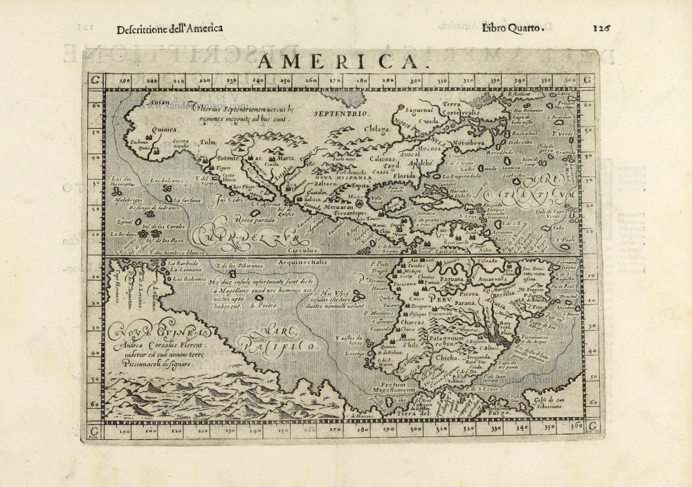
Old, antique map of America, by Sebastian Münster.
Title: Die Neüwen Inseln / so hinder Hispanien gegeu Orient / bey dem Landt India ligen.
Date of the first edition: 1540.
Date of this map: 1550.
Woodcut, printed on paper.
Map size: 255 x 340mm (10.04 x 13.39 inches).
Sheet size: 305 x 400mm (12.01 x 15.75 inches).
Verso: Latin text.
Condition: Tear in centre reinforced at the back, water stain in the upper right corner.
Condition Rating: B+.
References: Burden, #12, State 5; Karrow 58/117
From: Cosmographiae Universalis Lib. VI. . . . Basle, H. Petri, 1550.
In 1540 Sebastian Münster, one of the most influential cartographers of the sixteenth century published his edition of Ptolemy's Geography with a different section of modern, more up-to-date maps. For the first time, he included a set of continental maps; America was the earliest of any note. The map's inclusion in Münsters Cosmography, first published in 1544, sealed the fate of "America" as the name for the New World. The Portuguese flag is shown flying over the South Atlantic, and the Spanish one over her possessions in the Caribbean. The Strait of Magellan is named again, and Mare pacificum appears for the first time on a printed map. Magellan's ship Victoria, the only survivor of five vessels, appears in the middle of this ocean. Marco Polo's influence can be seen with Zipangri (Japan), appearing three years before the earliest known contact with Europeans and his Archipelagus 7448 insularu. The Yucatan is still shown as an island, and the lake at Temistitan is depicted emptying into the Gulf of Mexico. North America is not shown as accurately as the southern half of the continent; it had, to a large extent, been neglected so far by explorers. When Giovanni di Verrazzano, in the service of Francis I of France, passed by the Outer Banks of the Carolinas in 1524, he mistook Pamlico and Albemarle Sounds for the 'Oriental Sea' that led to Cathay and the rich Spice Islands. Here Münster perpetuated this error and provided a considerable impetus to exploring the region through the success of this book. The only place names occurring here are C. Britonum, marking England's early explorations, Corterati, probably Newfoundland after the Corte Reals, and Terra Florida. FRANCISCA is named in honour of Francis I. (Burden)
Sebastian Münster (1488-1552)
Sebastian Münster, a German geographer, cartographer, Hebraist, and theologian, was born in Ingelheim, near Mainz In 1505, he went to Heidelberg to enter the Franciscan order. In 1507 he went to Louvain, where he studied mathematics, geography, and astronomy. In 1509 Münster became a student of Konrad Pelikan, who taught Hebrew and Greek as well as mathematics and cosmography. In 1518 he completed his studies at the University of Tübingen. He was the favorite of the famous mathematician and astronomer Johann Stöffler.
In 1524 Münster was appointed professor of Hebrew at Heidelberg University. In 1525 he published his first map as part of a broadside: The Instrument of the Suns combined a map, calendar, astrological almanac, sundial, and nocturnal on one attractive sheet, suitable for wall mounting.
In 1540 he published a Latin edition of Ptolemy's Geographia with illustrations. He based this edition on the Latin translation by Willibald Pirkheimer and produced new maps to supplement the Ptolemaic maps. The twenty-seven maps of the Ptolemaic canon are supplemented by twenty-one new maps. Further editions appeared in 1541 and 1542.
In 1544 he published the Cosmographia, a bulky book with 659 pages and some 520 woodcuts. Maps in this edition included three maps from the Ptolemaic canon and fourteen modern maps (from previous editions of the Geographia), as well as nine new maps. Later editions (1545, 1546, 1548) enlarged the Cosmographia. The 1550 edition contains cities, portraits, and costumes. These editions in both Latin and German constitute the full fruition of Münster's dream of a comprehensive geography.
The Cosmographia was one of the most successful works of the 16th century. It passed through 24 editions in 100 years, in different languages, including Latin, French, Italian, English, and even Czech. The last German edition was published in 1628.
He died at Basel of the plague in 1552.
As a cartographer, Münster deserves special recognition for formulating a plan for a comprehensive and uniform map of a country. As a geographer, his greatest achievement was the Cosmographia. (Karrow).
Related items
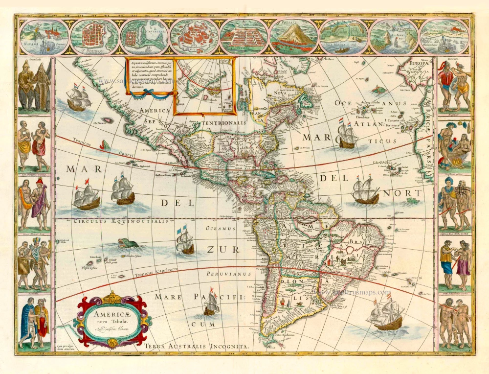
Americae nova Tabula. 1647-49
America, by Willem Blaeu.
[Item number: 6717]

America 1602
America by Langenes, published by Bertius P.
[Item number: 12494]
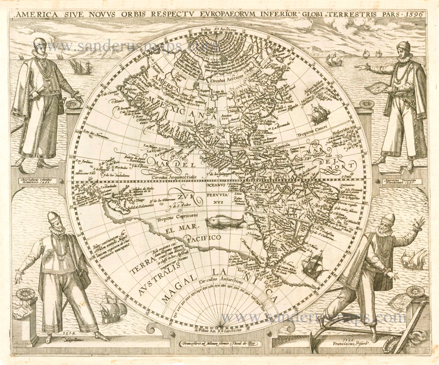
America Sive Novus Orbis Respectu Europaeorum Inferior Globi Terrestri Pars. 1596. 1596
The Americas by Theodore de Bry.
[Item number: 12546]
California as an island
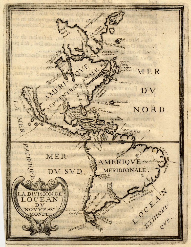
La Division de l'Ocean du Nouveau Monde 1648
America, by Briet Ph.
[Item number: 17771]
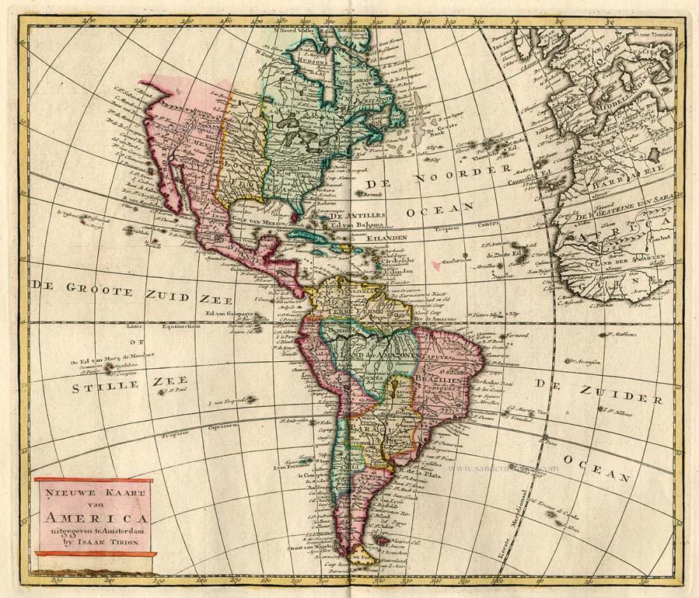
Nieuwe Kaart van America c. 1770
Antique map of America by Tirion I.
[Item number: 19194]

America. 1597
AMERICA by Giovanni Magini
[Item number: 22492]
Americae Sive Novi Orbis, Nova Descriptio. 1598
America, by Abraham Ortelius.
[Item number: 25618]
Americae tam Septentrionalis quam Meridionalis in Mappa Geographica Delineatio. c. 1700
America by A.F. Zürner, published by Petrus Schenk.
[Item number: 25715]
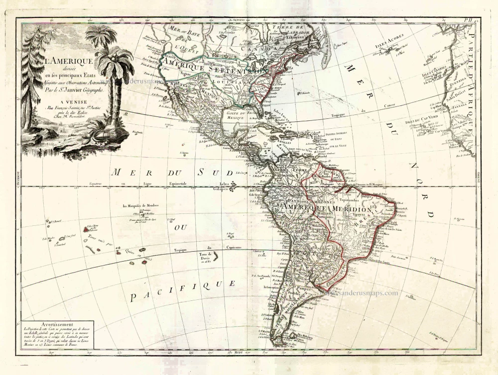
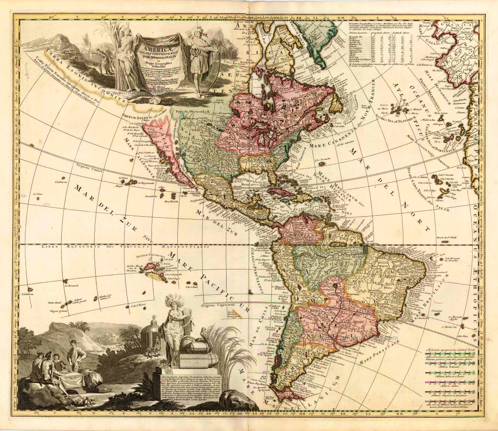
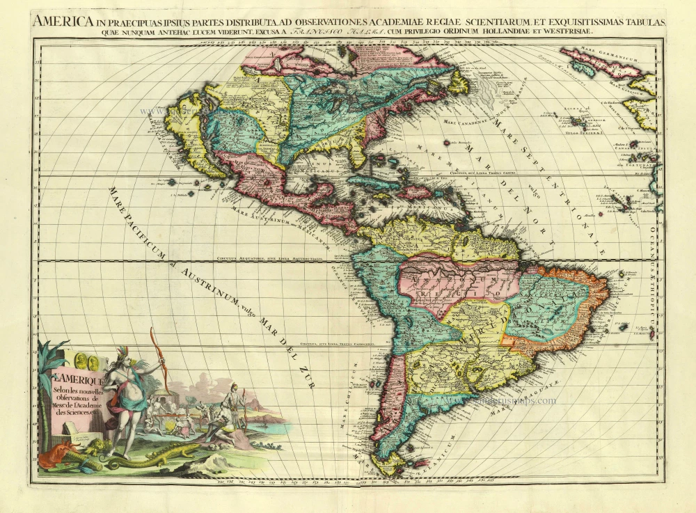
L'Amerique Divisée en ses Principaux Etats Assujettie aux Observations Astronomiqes. 1776-79
America, by Francesco Santini.
[Item number: 26978]
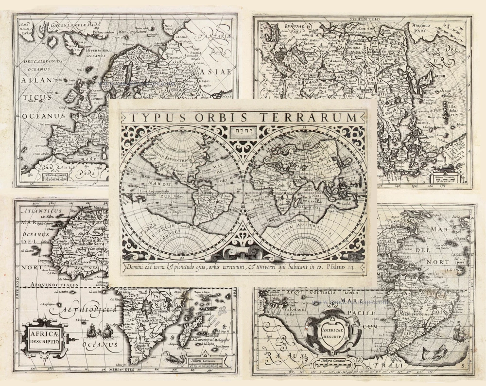
Typus Orbis Terrarum, [in set with:] Europa, [and] Asia, [and] Americae Descrip., [and] Africae Descriptio. 1607
World + Continents, by Jodocus Hondius.
[Item number: 27088]
Americae Sive Novi Orbis, Nova Descriptio. 1603
America by Abraham Ortelius.
[Item number: 27538]
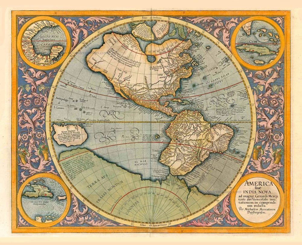
America sive India Nova. 1623
America, by Gerard Mercator.
[Item number: 27752]
Original Halma edition.
L'Amerique selon les Nouvelles Observations de Messrs. de l'Academie des Sciences, etc. Before 1713
America, by François Halma.
[Item number: 28017]
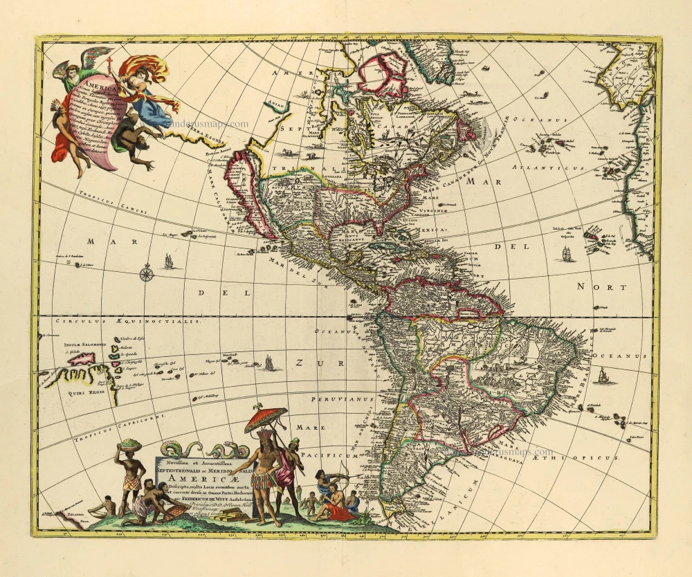
Novissima et Accuratissima Septentrionalis ac Meridionalis Americae. c. 1715
America by Frederick de Wit, published by Covens & Mortier.
[Item number: 28295]
America. 1598
America, by Giovanni Lorenzo d'Anania, published by Girolamo Ruscelli.
[Item number: 28432]
America. 1613
America by Jodocus Hondius.
[Item number: 28530]
Novissima et Accuratissima Totius Americae Descriptio. 1656-77
America by Nicolaes Visscher I.
[Item number: 28554]
First plate
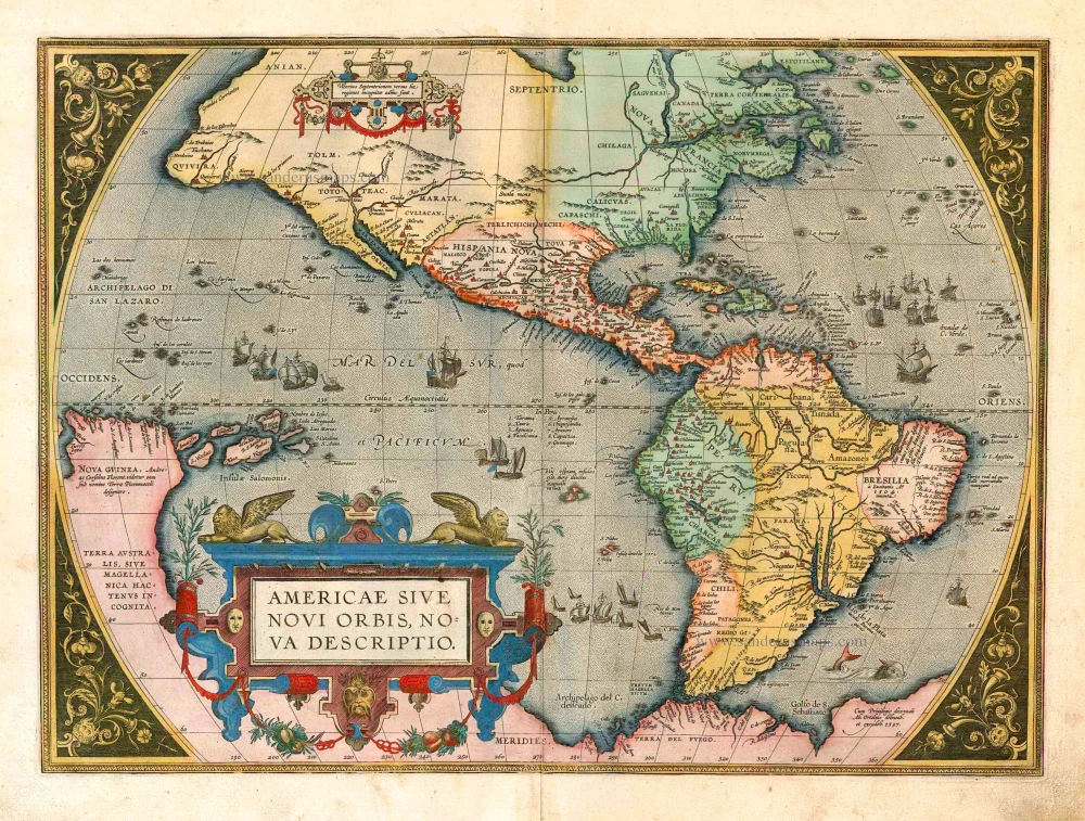
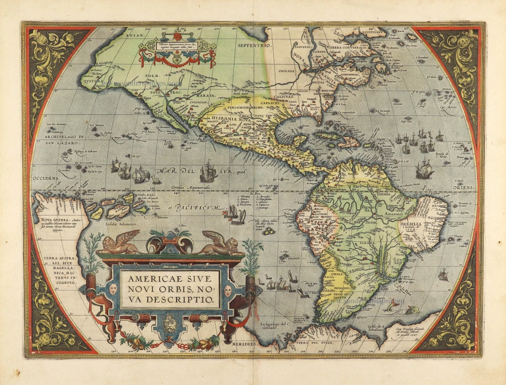
Americae Sive Novi Orbis, Nova Descriptio. 1572
America by Abraham Ortelius.
[Item number: 29237]
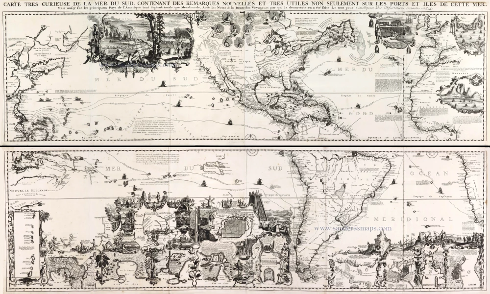
One of the most elaborately engraved maps ever published.
Carte tres Curieuse de la Mer du Sud, Contenant des Remarques Nouvelles et tres Utiles non Seulement sur les Ports et Iles de cette Mer, 1719
Pacific by Zacharias Châtelain after Nicolas de Fer.
[Item number: 29466]