
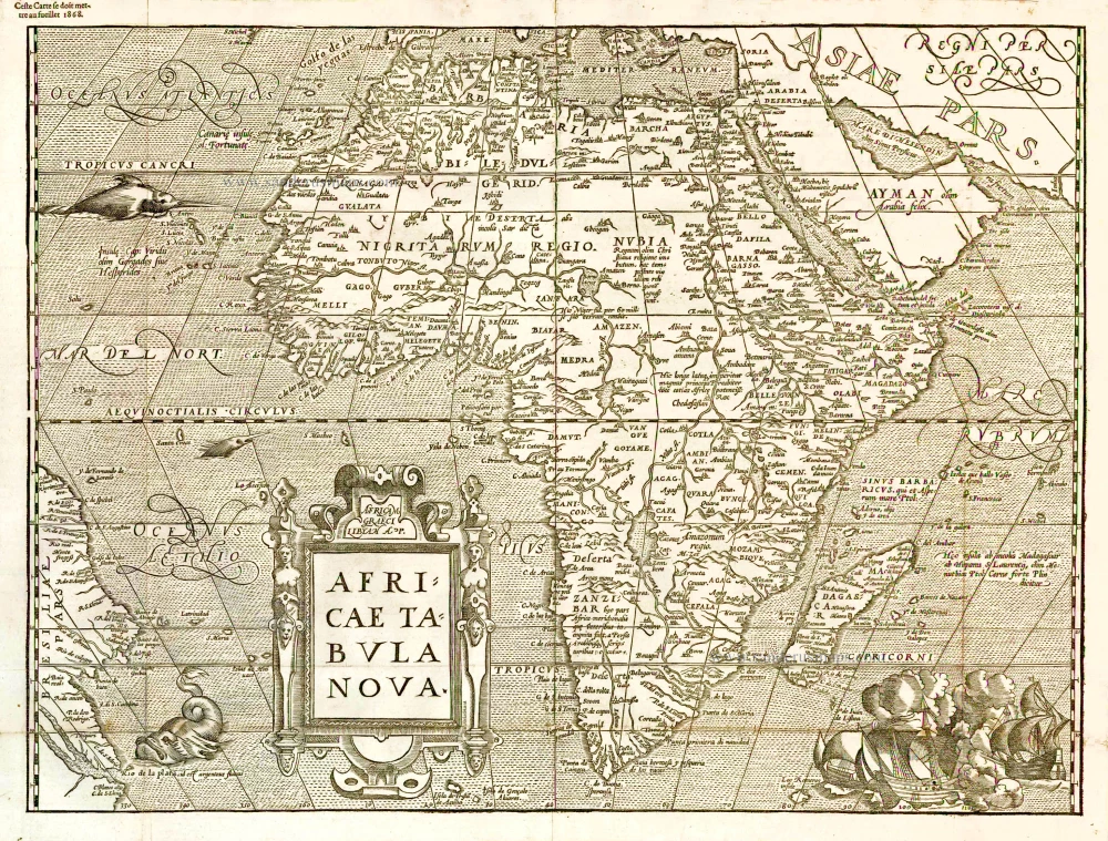
Africa by Willem Blaeu. 1642
The item displayed on this page has been sold. However, we have a similar map in stock:
Africa by Willem Blaeu. 1640
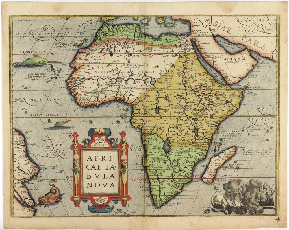
Africae nova descriptio.
[Item number: 31334]

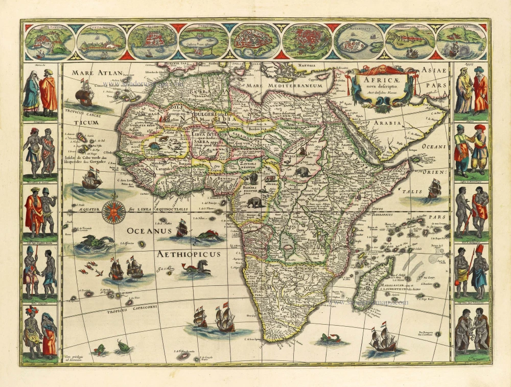


"This is one of the most decorative and popular of all the early maps of Africa. The cartouche is not very elaborate, but it is surmounted by what appears to be a lion with a flowing mane. The map itself is decorated with ships - seven in the Atlantic and two in the Indian Ocean - all flying Dutch flags; flying fish, whales and monsters are used to fill in the spaces in the oceans while elephants, monkeys and lions, ostriches and camels are depicted wandering all over the continent. Each side border is filled with decorative vignettes of costumed couples from various parts of Africa. The top border features oval vignettes of nine principal cities. The Nile is shown according to Ptolemy with its sources in Lakes Zaire and Zaflan; the fictitious Lake Sachaf of Laurent Fries appears, and the R. de Spirito Santo. The only names shown at the Cape are coastal ones, engraved inwards to give an appearance of fullness to the map, leaving the contours clear and sharp." (Norwich)
The Blaeus: Willem Janszoon, Cornelis & Joan
Willem Jansz. Blaeu and his son Joan Blaeu are the seventeenth century's most widely known cartographic publishers.
Willem Jansz. (also written Guilielmus Janssonius) = Willem Janszoon Blaeu was born in Uitgeest (Netherlands), near Alkmaar, in 1571. He studied mathematics under Tycho Brahe and learned the theory and practice of astronomical observations and the art of instrument- and globe-making.
In 1596, he came to Amsterdam, where he settled down as a globe-, instrument- and mapmaker. He published his first cartographic work (a globe) in 1599 and probably published his first printed map (a map of the Netherlands) in 1604. He specialised in maritime cartography, published the first edition of the pilot guide Het Licht der Zeevaert in 1608, and was appointed Hydrographer of the V.O.C. (United East India Company) in 1633. After publishing books, wall maps, globes, charts and pilot guides for thirty years, he brought out his first atlas, Atlas Appendix (1630). This was the beginning of the great tradition of atlas-making by the Blaeus.
In 1618, another mapmaker, bookseller and publisher, Johannes Janssonius, established himself in Amsterdam next door to Blaeu's shop. No wonder these two neighbours began accusing each other of copying and stealing their information and became fierce competitors who did not have a good word to say about each other. In about 1621 Willem Jansz. decided to end the confusion between his name and his competitor's and assumed his grandfather's nickname, 'blauwe Willem' ('blue Willem'), as the family name; after that, he called himself Willem Jansz. Blaeu.
Willem Janszoon Blaeu died in 1638, leaving his prospering business to his sons, Cornelis and Joan. We only know that Cornelis's name occurs in the prefaces of books and atlases until c. 1645.
Joan Blaeu, born in Amsterdam in 1596, became a partner in his father's book trade and printing business. 1638, he was appointed his father's successor in the Hydrographic Office of the V.O.C. His efforts culminated in the magnificent Atlas Major and the town books of the Netherlands and Italy – works unsurpassed in history and modern times, giving eternal fame to the name of the Blaeu's.
A fire ruined the business on February 23, 1672, and one year later, Dr. Joan Blaeu died. The fire and the director's passing caused the complete sale of the Blaeu House's stock. Five public auctions dispersed the remaining books, atlases, copperplates, globes, etc., among many other map dealers and publishers in Amsterdam. The majority was acquired by several booksellers acting in partnership.
In the succeeding years, the remaining printing department remained in the hands of the Blaeu family until 1695, when the printing house's inventory was sold at a public auction. That meant the end of the Blaeu family as a printing house of world renown.
Africae nova descriptio.
Item Number: 28388 Authenticity Guarantee
Category: Antique maps > Africa
Old, antique map of Africa by Willem & Joan Blaeu.
Title: Africae nova descriptio.
Auct: Guiljelmo Blaeuw.
Cum privilegio ad decennium.
Oriented to the west.
Date of the first edition: 1630.
Date of this map: 1642.
Copper engraving, printed on paper.
Map size: 410 x 553mm (16.14 x 21.77 inches).
Sheet size: 505 x 600mm (19.88 x 23.62 inches).
Verso: German text.
Condition: Original coloured, excellent.
Condition Rating: A+.
References: Schilder 6, #11.3; Betz, #57.2; Van der Krogt 2, 8600:2; Norwich O.I, #32
From: Novus Atlas, Das ist, Weltbeschreibung, ... Amsterdam, J. Blaeu, 1641. (Van der Krogt 2, 231)
"This is one of the most decorative and popular of all the early maps of Africa. The cartouche is not very elaborate, but it is surmounted by what appears to be a lion with a flowing mane. The map itself is decorated with ships - seven in the Atlantic and two in the Indian Ocean - all flying Dutch flags; flying fish, whales and monsters are used to fill in the spaces in the oceans while elephants, monkeys and lions, ostriches and camels are depicted wandering all over the continent. Each side border is filled with decorative vignettes of costumed couples from various parts of Africa. The top border features oval vignettes of nine principal cities. The Nile is shown according to Ptolemy with its sources in Lakes Zaire and Zaflan; the fictitious Lake Sachaf of Laurent Fries appears, and the R. de Spirito Santo. The only names shown at the Cape are coastal ones, engraved inwards to give an appearance of fullness to the map, leaving the contours clear and sharp." (Norwich)
The Blaeus: Willem Janszoon, Cornelis & Joan
Willem Jansz. Blaeu and his son Joan Blaeu are the seventeenth century's most widely known cartographic publishers.
Willem Jansz. (also written Guilielmus Janssonius) = Willem Janszoon Blaeu was born in Uitgeest (Netherlands), near Alkmaar, in 1571. He studied mathematics under Tycho Brahe and learned the theory and practice of astronomical observations and the art of instrument- and globe-making.
In 1596, he came to Amsterdam, where he settled down as a globe-, instrument- and mapmaker. He published his first cartographic work (a globe) in 1599 and probably published his first printed map (a map of the Netherlands) in 1604. He specialised in maritime cartography, published the first edition of the pilot guide Het Licht der Zeevaert in 1608, and was appointed Hydrographer of the V.O.C. (United East India Company) in 1633. After publishing books, wall maps, globes, charts and pilot guides for thirty years, he brought out his first atlas, Atlas Appendix (1630). This was the beginning of the great tradition of atlas-making by the Blaeus.
In 1618, another mapmaker, bookseller and publisher, Johannes Janssonius, established himself in Amsterdam next door to Blaeu's shop. No wonder these two neighbours began accusing each other of copying and stealing their information and became fierce competitors who did not have a good word to say about each other. In about 1621 Willem Jansz. decided to end the confusion between his name and his competitor's and assumed his grandfather's nickname, 'blauwe Willem' ('blue Willem'), as the family name; after that, he called himself Willem Jansz. Blaeu.
Willem Janszoon Blaeu died in 1638, leaving his prospering business to his sons, Cornelis and Joan. We only know that Cornelis's name occurs in the prefaces of books and atlases until c. 1645.
Joan Blaeu, born in Amsterdam in 1596, became a partner in his father's book trade and printing business. 1638, he was appointed his father's successor in the Hydrographic Office of the V.O.C. His efforts culminated in the magnificent Atlas Major and the town books of the Netherlands and Italy – works unsurpassed in history and modern times, giving eternal fame to the name of the Blaeu's.
A fire ruined the business on February 23, 1672, and one year later, Dr. Joan Blaeu died. The fire and the director's passing caused the complete sale of the Blaeu House's stock. Five public auctions dispersed the remaining books, atlases, copperplates, globes, etc., among many other map dealers and publishers in Amsterdam. The majority was acquired by several booksellers acting in partnership.
In the succeeding years, the remaining printing department remained in the hands of the Blaeu family until 1695, when the printing house's inventory was sold at a public auction. That meant the end of the Blaeu family as a printing house of world renown.
Related items
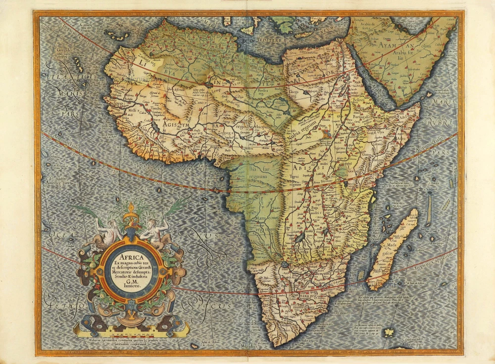
Africa Ex magna orbis terre 1633
Africa, by G. Mercator.
[Item number: 1452]
Africa Ex magna orbis terre. 1623
Africa by Gerard Mercator.
[Item number: 24900]
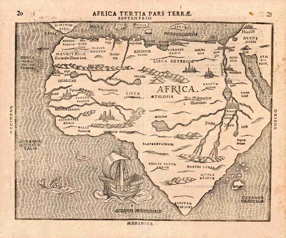
Africa Tertia Pars Terrae. 1581
Africa, by H. Bünting.
[Item number: 26228]
Rare.
[No title] c. 1575
Atlantic Ocean - Europe, Africa & Eastern Canada by Giovanni Francesco Camocio
[Item number: 27086]
Scarce
Africae Tabula Nova. 1575
Africa, by François de Belleforest.
[Item number: 27380]
Affricae Tabula Nova. 1598
Africa, by Sebastian Münster.
[Item number: 27416]
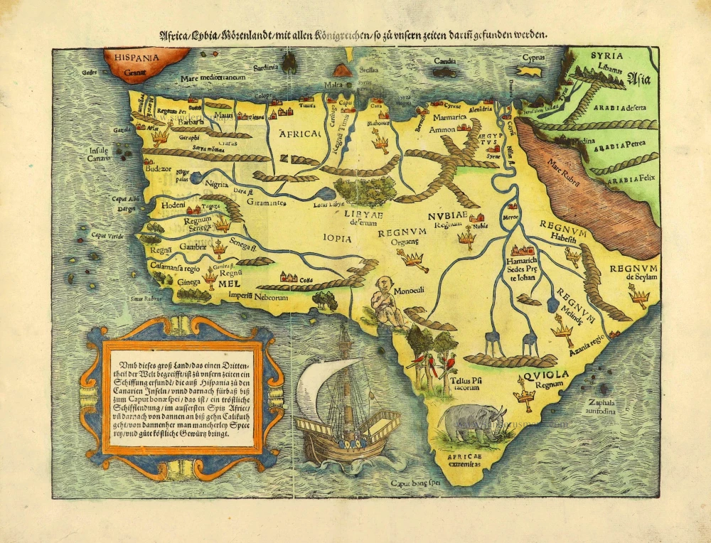
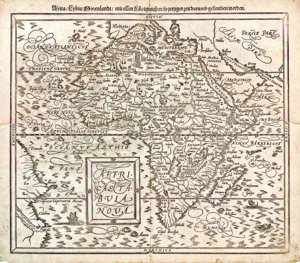
Africa / Lybia / Morenland / mit allen Künigreichen / so zu unsern zeiten darin gefunden werden. 1572
Africa by Sebastian Münster.
[Item number: 28142]
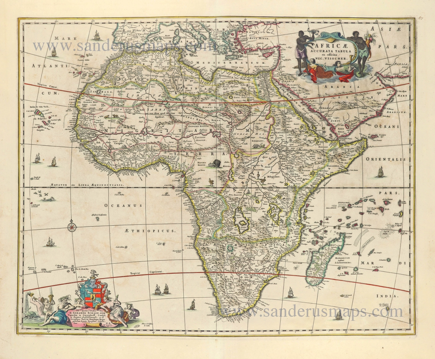
Africae Accurata Tabula. 1656-77
Africa by Nicolaes Visscher I.
[Item number: 28551]
Africa Ex magna orbis terre. 1623
Africa by Gerard Mercator.
[Item number: 28678]
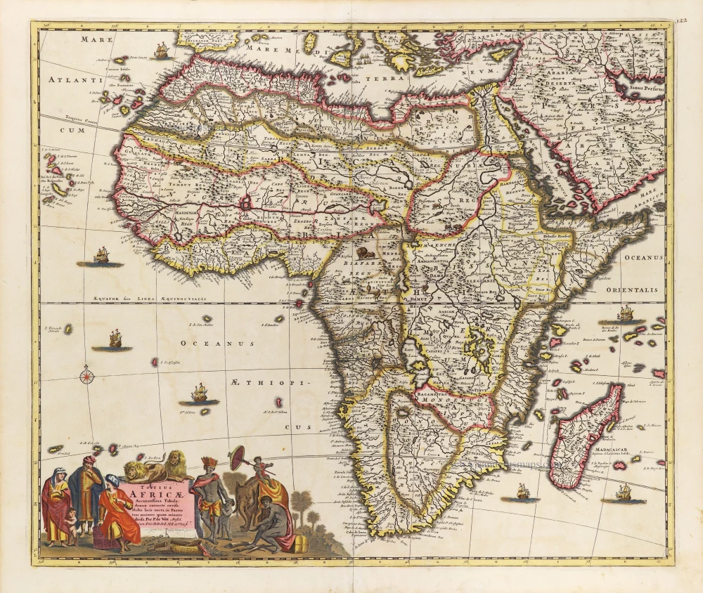
Totius Africae Accuratissima Tabula, c. 1697-1704
Africa, by Frederick De Wit.
[Item number: 29289]
Important map
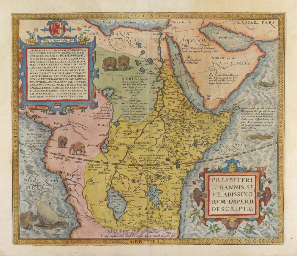
Presbiteri Iohannis, sive, Abissinorum Imperii Descriptio. 1584
Prestor John Map (Western & Central Africa), by Abraham Ortelius.
[Item number: 29722]
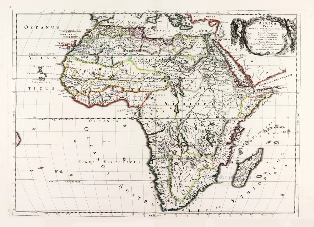
Africa Vetus. 1667-69
Ancient Africa by Nicolas & Guillaume Sanson.
[Item number: 30003]
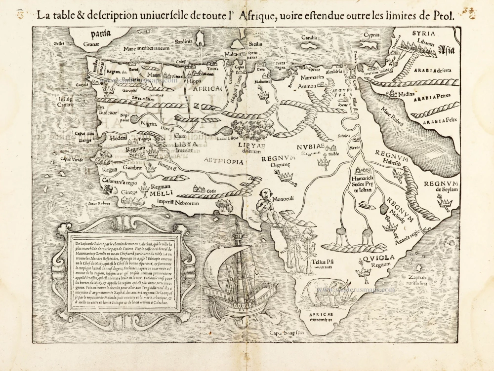
La table & description universelle de toute l' Afrique, voire estendue outre les limites de Ptol. 1568
AFRICA by Sebastian Münster
[Item number: 30519]
Africa 1621
Africa by Giovanni Magini.
[Item number: 30775]
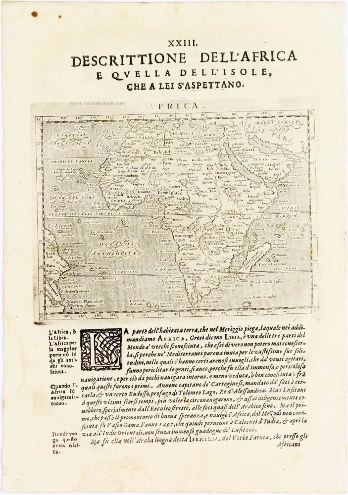
Important map
Africae Tabula Nova. 1575
Africa by Abraham Ortelius
[Item number: 30948]
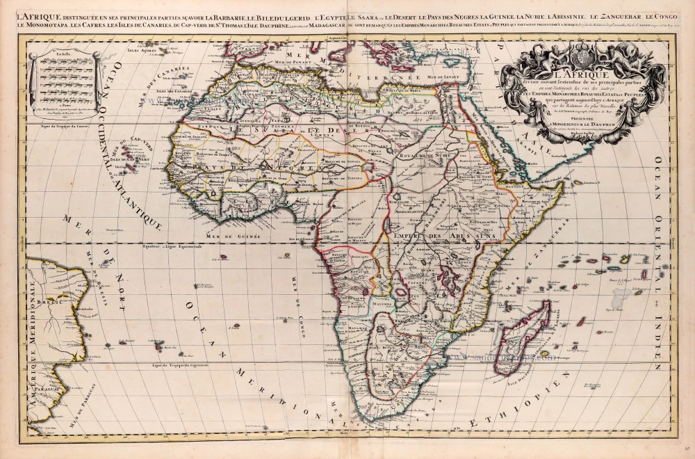
L'Afrique divisée suivant l'estendue de ses principales parties ou sont distingués les uns des autres, Les Empires, Monarchies, Royaumes, Estats et Peuples qui partagent aujourd'huy l'Afrique sur les Relations les plus Nouvelles. 1692
Africa, by N. Sanson, so-called published by Hubert Jaillot. (Pirated edition by Pierre Mortier).
[Item number: 31141]