
Northern Africa, by Francesco Santini. 1776-79
Francesco and Paolo Santini (c.1729-1793)
Francesco Santini, a Venetian publisher, acquired the printing plates of Vaugondy’s Atlas Universel …, a commercial and cartographic success, with widespread influence on mapmakers throughout Europe. Together with his brother Paolo, he commissioned a new set of plates and reissued the atlas in 1776. The following year, Paolo Santini assigned all his publication rights to M. Remondini, who in 1777 reissued the same atlas but with his name.
Gilles and Didier Robert de Vaugondy
Gilles Robert de Vaugondy (1688-1766) and his son Didier Robert de Vaugondy (1723-1786) were leading cartographers in France during the 18th century. They served both as geographer to the king of France. The father, Gilles is also known as ‘Le Sieur’ or ‘Monsieur Robert’. He descended from the Nicolas Sanson family through Sanson's grandson Pierre Moulard-Sanson, from whom he inherited Sanson's cartographic material. After Hubert Jaillot died in 1712, the de Vaugondy's acquired numerous copies of his maps and plates, which formed the basis of their beautiful Atlas Universel (1757).
Their business flourished from 1731 to 1778. They made a substantial contribution to the world of cartography.
Jean-Baptiste Bourguignon d'Anville (1697 -1782)
French geographer and cartographer to the king. He made more than 200 maps during his life. His maps remained the reference point in cartography throughout the 19th century.
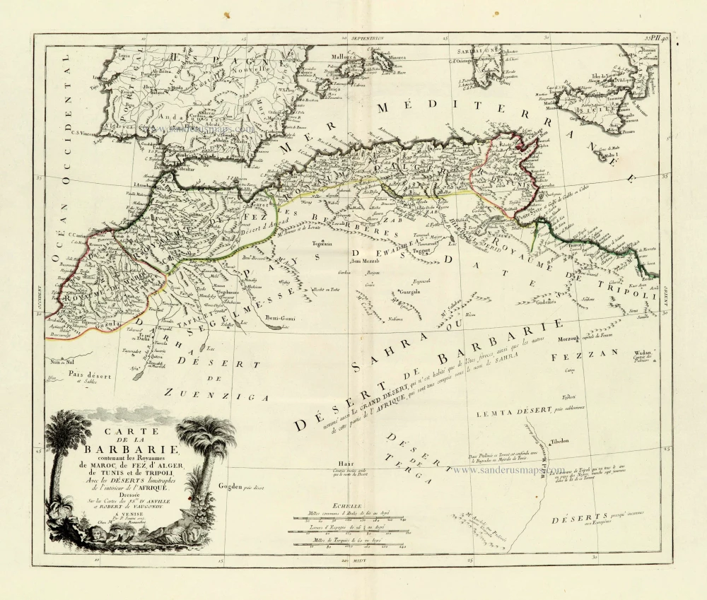
Carte de la Barbarie, contenant les Royaumes de Maroc, de Fez, d'Alger, de Tunis et de Tripoli, Avec les Déserts limitrophes de l'intérieur de l'Afrique.
Item Number: 28098 Authenticity Guarantee
Category: Antique maps > Africa
Old, antique map of Northern Africa, by Paolo Santini.
Title: Carte de la Barbarie, contenant les Royaumes de Maroc, de Fez, d'Alger, de Tunis et de Tripoli, Avec les Déserts limitrophes de l'intérieur de l'Afrique.
Dressée Sur les Cartes des SS.rs D'Anville et Robert de Vaugondy.
A Venise | Par François Santini 1775.
Chez Mr. Remondini.
Cartographer: Sr. D'Anville & Robert de Vaugondy.
Date of the first edition: 1775.
Date of this map: 1776-79.
Date on map: 1775.
Copper engraving, printed on paper.
Size (not including margins): 460 x 545mm (18.11 x 21.46 inches).
Verso: Blank.
Condition: Original coloured in outline, excellent.
Condition Rating: A+.
From: Atlas Universel dressé sur les meilleures cartes modernes. Venice, Remondini, 1776-79.
Francesco and Paolo Santini (c.1729-1793)
Francesco Santini, a Venetian publisher, acquired the printing plates of Vaugondy’s Atlas Universel …, a commercial and cartographic success, with widespread influence on mapmakers throughout Europe. Together with his brother Paolo, he commissioned a new set of plates and reissued the atlas in 1776. The following year, Paolo Santini assigned all his publication rights to M. Remondini, who in 1777 reissued the same atlas but with his name.
Gilles and Didier Robert de Vaugondy
Gilles Robert de Vaugondy (1688-1766) and his son Didier Robert de Vaugondy (1723-1786) were leading cartographers in France during the 18th century. They served both as geographer to the king of France. The father, Gilles is also known as ‘Le Sieur’ or ‘Monsieur Robert’. He descended from the Nicolas Sanson family through Sanson's grandson Pierre Moulard-Sanson, from whom he inherited Sanson's cartographic material. After Hubert Jaillot died in 1712, the de Vaugondy's acquired numerous copies of his maps and plates, which formed the basis of their beautiful Atlas Universel (1757).
Their business flourished from 1731 to 1778. They made a substantial contribution to the world of cartography.
Jean-Baptiste Bourguignon d'Anville (1697 -1782)
French geographer and cartographer to the king. He made more than 200 maps during his life. His maps remained the reference point in cartography throughout the 19th century.
Related items

Africae Propriae Tabula. 1624
Ancient Northern Africa, by Ortelius A.
[Item number: 2053]

Barbaria 1613-16
Northern Africa by J. Hondius
[Item number: 13746]

Africae Propriae Tabula .. 1645-58
Northern Africa, by Janssonius J.
[Item number: 19443]

Barbariae et Biledulgerid, Nova Descriptio. 1601
Northern Africa, by A. Ortelius.
[Item number: 22524]

Barbaria 1662
Northern Africa, by Blaeu J.
[Item number: 22814]

Nouvelle Carte du Roiaume d'Alger, divisée en toutes ses provinces, avec une partie du Côtes d'Espagne &c. 1756
Northern Africa - Algeria (Algiers) by Ottens R. & J.
[Item number: 23495]

Barbaria c. 1680
Northern Africa, by F. de Wit.
[Item number: 24490]

Barbarie, Biledulgerid, (autrefois Libye) et une partie du Pays des Negres. 1713
Northern Africa (Barbary), by Pieter van der Aa.
[Item number: 26154]

Aphricae Tabula II. 1571
Tunisia by Strabo - Sebastian Münster
[Item number: 27694]

Tabula nova partis Africae. 1525
Northern Africa by Lorenz Fries
[Item number: 27946]

Ptolemaic map of the African continent
[Title on verso:] Tabula .IIII. Aphricae. 1525
Africa, by Lorenz Fries,
[Item number: 27976]

Parergon map
Africae Propriae Tabula, In qua, Punica regna vides; Tyrios, et Agenoris urbem. 1609
Abraham Ortelius, Ancient Northern Africa.
[Item number: 29348]

Barbariae et Biledulgerid, Nova Descriptio. 1584
Northern Africa, by Abraham Ortelius.
[Item number: 29356]

Carte de la Barbarie, Nigritie et de la Guinee avec les Pays Voisins, 1719
Northwest Africa, by Z. Châtelain.
[Item number: 29369]

Carte Particuliere de l'Egypte, de la Nubie et de l'Abyssinie. 1719
Northeast Africa & Arabia, by Z. Châtelain.
[Item number: 29371]

Antiquorum Africae Episcopatuum Geographice Descriptio. 1640
Northern Africa by Melchior Tavernier, published for Nicolas Sanson.
[Item number: 30001]

Tabula Aphricae III. 1545
Northern Africa by Sebastian Münster.
[Item number: 30293]

Barbaria. 1618
Northern Africa by Petrus Bertius, published by Jodocus Hondius II.
[Item number: 32067]