
Tianjin (Tientsin - China), by Petrus Schenk. 1702

The Schenk Family
Petrus Schenk (1660-1718), the founder of one of the best-known publishing firms of Amsterdam in the 18th century, was born in Elberfeld, Germany, in 1660. He went to Amsterdam, where he became a pupil of the engraver Gerard Valck. On 19 Nov. 1686, a privilegio was granted to Petrus Schenk and Gerard Valk for the manufacturing and selling their prints—Schenk’s contribution to cartography dates from c. 1695. In 1706, he moved to the Vijgendam in Amsterdam, ‘in Sanson’s Atlas’. After he died in 1718, his son, Leonardus Schenk, continued the art and print shop. The second son, Petrus II (1693-1775), settled in another famous house: ‘in Visscher’s Atlas’, where he continued associating with Gerard and Leonarus Valck.
The Schenk family produced general geographical atlases and special atlases. Apart from seventy original maps, several hundred are known as Schenk, printed from plates obtained from Janssonius and Visscher. Schenk and Valck acquired all the plates of the Janssonius Heir’s Novus Atlas, including the Celestial Atlas. Many of Janssonius’ plates were reworked and amended.
Republishing maps from Janssonius’ Novus Atlas since c. 1680 was followed by engraving new maps copied from Sanson’s better and more modern maps. Petrus Schenk published these maps in his Atlas Contractus sive mapparum geographicarum Sansoniarum auctarum et correctum Nova Congeries, also called Atlas Minor. After 1719, Petrus Schenk II continued the Atlas Contractus.
Petrus Schenk, the elder, enjoyed great fame as a print seller and artist among art and print dealers in the whole of Europe. The great activity in map publishing, displayed by Petrus Schenk, the elder, was continued by his son and grandson. But the number of original atlas maps is small. Like his father, who bought the copperplates of Janssonius’ atlas, Petrus Schenk II bought many of the plates formerly owned by Nicolaas Visscher.
Apart from the globes, maps and atlases, Petrus Schenk II published many books. In 1733, he was older men of the booksellers guild in 1733.
Petrus Schenk Junior (1728-1803) was an engraver and artseller. He continued to publish many of the titles his father and grandfather issued, and the globes of his uncle Leonard Valk.
Kuchin een Sineesche stadt in het lantschap Peking, aen de rivier Guci, de gemeene vryplaets des vluchtelingen van Sina en Korea = Kuchin Urbs regionis Peking, ...
Item Number: 26659 Authenticity Guarantee
Category: Antique maps > Asia > China
Old, antique view of Tianjin (Tientsin - China), by Petrus Schenk.
Date of the first edition: 1702
Date of this map: 1702
Copper engraving, printed on paper.
Size (not including margins): 21 x 26cm (8.2 x 10.1 inches)
Verso: Blank
Condition Rating: A+
References: Van der Krogt 4, #4307; Fauser, #7063.
From: Petri Schenkii Hecatompolis, sive Totius orbis Terrarum Oppida Nobiliora Centum; exquisite collecta atque eleganter depicta. Amsterdam, Petrus Schenk, 1702.
The Schenk Family
Petrus Schenk (1660-1718), the founder of one of the best-known publishing firms of Amsterdam in the 18th century, was born in Elberfeld, Germany, in 1660. He went to Amsterdam, where he became a pupil of the engraver Gerard Valck. On 19 Nov. 1686, a privilegio was granted to Petrus Schenk and Gerard Valk for the manufacturing and selling their prints—Schenk’s contribution to cartography dates from c. 1695. In 1706, he moved to the Vijgendam in Amsterdam, ‘in Sanson’s Atlas’. After he died in 1718, his son, Leonardus Schenk, continued the art and print shop. The second son, Petrus II (1693-1775), settled in another famous house: ‘in Visscher’s Atlas’, where he continued associating with Gerard and Leonarus Valck.
The Schenk family produced general geographical atlases and special atlases. Apart from seventy original maps, several hundred are known as Schenk, printed from plates obtained from Janssonius and Visscher. Schenk and Valck acquired all the plates of the Janssonius Heir’s Novus Atlas, including the Celestial Atlas. Many of Janssonius’ plates were reworked and amended.
Republishing maps from Janssonius’ Novus Atlas since c. 1680 was followed by engraving new maps copied from Sanson’s better and more modern maps. Petrus Schenk published these maps in his Atlas Contractus sive mapparum geographicarum Sansoniarum auctarum et correctum Nova Congeries, also called Atlas Minor. After 1719, Petrus Schenk II continued the Atlas Contractus.
Petrus Schenk, the elder, enjoyed great fame as a print seller and artist among art and print dealers in the whole of Europe. The great activity in map publishing, displayed by Petrus Schenk, the elder, was continued by his son and grandson. But the number of original atlas maps is small. Like his father, who bought the copperplates of Janssonius’ atlas, Petrus Schenk II bought many of the plates formerly owned by Nicolaas Visscher.
Apart from the globes, maps and atlases, Petrus Schenk II published many books. In 1733, he was older men of the booksellers guild in 1733.
Petrus Schenk Junior (1728-1803) was an engraver and artseller. He continued to publish many of the titles his father and grandfather issued, and the globes of his uncle Leonard Valk.
Related items

Imperii Sinarum Nova Descriptio. c. 1680.
China with Japan, Korea and Taiwan, by J. Janssonius.
[Item number: 2618]

Pecheli, Xansi, Xantung, Honan, Nanking, In plaga Regni Sinensis in ter Septentrionem ac OrientemCeciam versus sitae Provinciae. c. 1700
Northeastern China, by Valk G. & Schenk P.
[Item number: 2694]
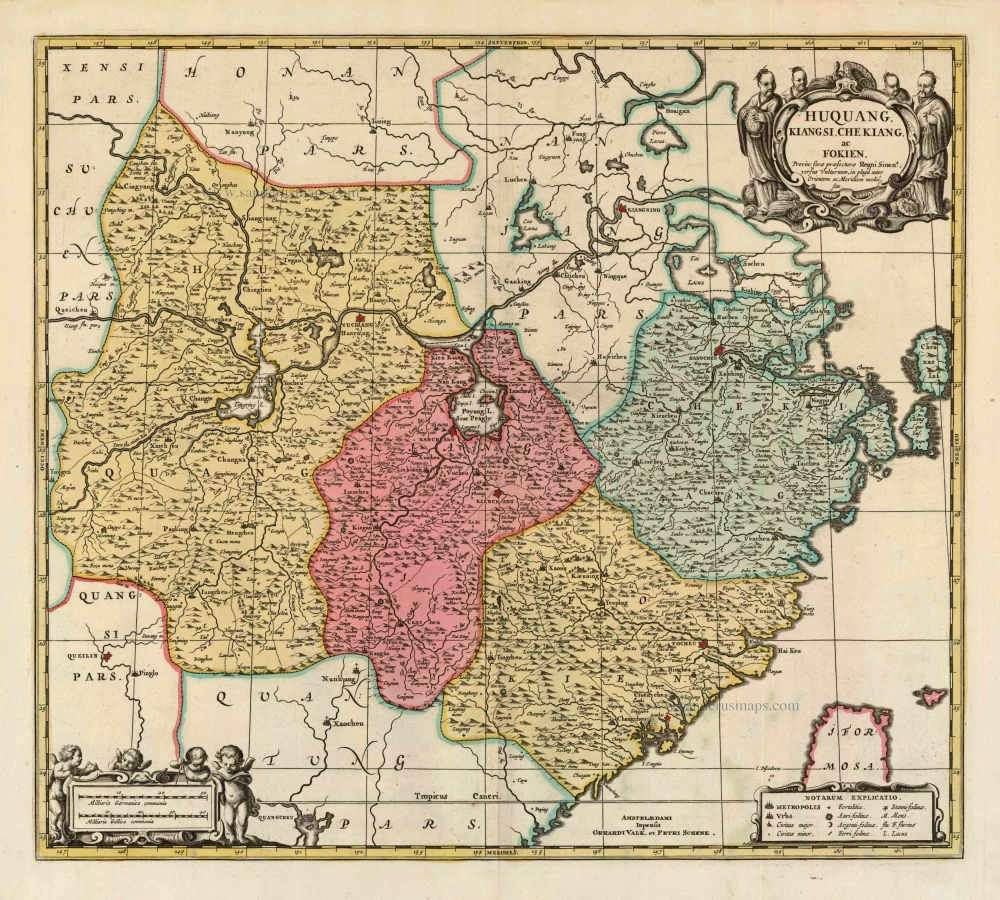
Huquang, Kiangsi, Che Kiang, ac Fokien. Provin: sivae praefecturae Regni Sinen:s, versus Vulturnum, in plaga inter Orientem ac Meridiem media, sitae. c. 1700
Eastern China, by Valk and Schenk.
[Item number: 8453]

Kiangsi, Imperii Sinarum Provincia Octava. 1655-1659
China - Chiang-hsi, by J. Blaeu.
[Item number: 26589]

Batavia, gelegen op het eiland Java, een beroemde volkplanting der Batavieren. = Batavia Nova, Kalappa & Jacatra prius dicta in insula Java Batavorum nobilis colonia. 1702
Jakarta (Batavia), by Petrus Schenk
[Item number: 26660]
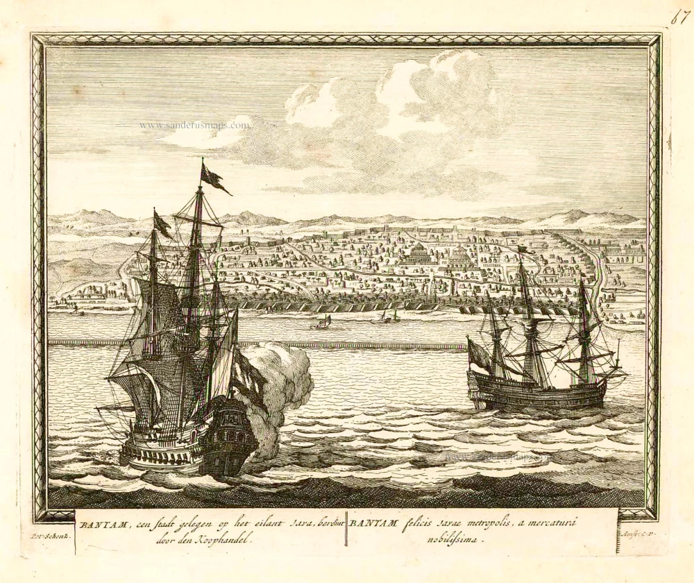
Bantam, een stadt gelegen op het eilant Java, beroemt door den Koophandel. = Bantam felicis Javae metropolis, a mercaturi nobilissima. 1702
Banten (Bantam - Indonesia), by Petrus Schenk.
[Item number: 26661]

La Chine, Suivant les Nouvelles Observations. 1713
China, by Pieter van der Aa.
[Item number: 27095]

Very decorative map in excellent condition.
Pecheli, sive Peking Imperii Sinarum Provincia Prima. 1655-1659
Bejing by Joan Blaeu.
[Item number: 29021]

Royaume de la Chine. 1682
China by Nicolas Sanson, published by Simon de Vries.
[Item number: 30235]

SCARCE !
Kuching. 1685/90
View of Tianjin (Tientsin - China), by Carel Allard.
[Item number: 30585]

China. 1618
China by Petrus Bertius, published by Jodocus Hondius II.
[Item number: 32151]