
China with Japan, Korea and Taiwan, by J. Janssonius. c. 1680.

The Janssonius Family
Joannes Janssonius (Arnhem, 1588-1664), son of the Arnhem publisher Jan Janssen, married Elisabeth Hondius, daughter of Jodocus Hondius, in Amsterdam in 1612. After his marriage, he settled down in this town as a bookseller and publisher of cartographic material. In 1618, he established himself in Amsterdam next door to Blaeu’s bookshop. He entered into serious competition with Willem Jansz. Blaeu when copying Blaeu’s Licht der Zeevaert after the expiration of the privilege in 1620. His activities concerned the publication of atlases, books, single maps, and an extensive book trade with branches in Frankfurt, Danzig, Stockholm, Copenhagen, Berlin, Koningsbergen, Geneva, and Lyon. In 1631, he began publishing atlases together with Henricus Hondius.
In the early 1640s, Henricus Hondius left the atlas publishing business to Janssonius. Competition with Joan Blaeu, Willem’s son and successor, in atlas production, prompted Janssonius to enlarge his Atlas Novus finally into a work of six volumes, into which a sea atlas and an atlas of the Old World were inserted. Other atlases published by Janssonius are Mercator’s Atlas Minor, Hornius’s historical atlas (1652), the townbooks in eight volumes (1657), Cellarius’s Atlas Coelestis and several sea atlases and pilot guides.
After the death of Joannes Janssonius, the shop and publishing firm were continued by the heirs under the direction of Johannes van Waesbergen (c. 1616-1681), son-in-law of Joannes Janssonius. Van Waesbergen added Janssonius's name to his own.
In 1676, Joannes Janssonius’s heirs sold by auction “all the remaining Atlases in Latin, French, High and Low German, as well as the Stedeboecken in Latin, in 8 volumes, bound and unbound, maps, plates belonging to the Atlas and Stedeboecken.” The copperplates from Janssonius’s atlases were afterwards sold to Schenk and Valck.
Imperii Sinarum Nova Descriptio.
Item Number: 2618 Authenticity Guarantee
Category: Antique maps > Asia > China
Old, antique map of China with Japan, Korea and Taiwan by J. Janssonius.
Title: Imperii Sinarum Nova Descriptio.
Cartographer: Van Loon J..
Date of the first edition: 1666.
Date of this map: c. 1680..
Copper engraving, printed on paper.
Size (not including margins): 470 x 525mm (18.5 x 20.67 inches).
Verso: Blank.
Condition: Contemporary old coloured, excellent.
Condition Rating: A.
From: Ioannis Ianssonii Novus Atlas, sive Theatrum Orbis Terrarum . . . Amsterdam, c. 1680.
The Janssonius Family
Joannes Janssonius (Arnhem, 1588-1664), son of the Arnhem publisher Jan Janssen, married Elisabeth Hondius, daughter of Jodocus Hondius, in Amsterdam in 1612. After his marriage, he settled down in this town as a bookseller and publisher of cartographic material. In 1618, he established himself in Amsterdam next door to Blaeu’s bookshop. He entered into serious competition with Willem Jansz. Blaeu when copying Blaeu’s Licht der Zeevaert after the expiration of the privilege in 1620. His activities concerned the publication of atlases, books, single maps, and an extensive book trade with branches in Frankfurt, Danzig, Stockholm, Copenhagen, Berlin, Koningsbergen, Geneva, and Lyon. In 1631, he began publishing atlases together with Henricus Hondius.
In the early 1640s, Henricus Hondius left the atlas publishing business to Janssonius. Competition with Joan Blaeu, Willem’s son and successor, in atlas production, prompted Janssonius to enlarge his Atlas Novus finally into a work of six volumes, into which a sea atlas and an atlas of the Old World were inserted. Other atlases published by Janssonius are Mercator’s Atlas Minor, Hornius’s historical atlas (1652), the townbooks in eight volumes (1657), Cellarius’s Atlas Coelestis and several sea atlases and pilot guides.
After the death of Joannes Janssonius, the shop and publishing firm were continued by the heirs under the direction of Johannes van Waesbergen (c. 1616-1681), son-in-law of Joannes Janssonius. Van Waesbergen added Janssonius's name to his own.
In 1676, Joannes Janssonius’s heirs sold by auction “all the remaining Atlases in Latin, French, High and Low German, as well as the Stedeboecken in Latin, in 8 volumes, bound and unbound, maps, plates belonging to the Atlas and Stedeboecken.” The copperplates from Janssonius’s atlases were afterwards sold to Schenk and Valck.
Related items
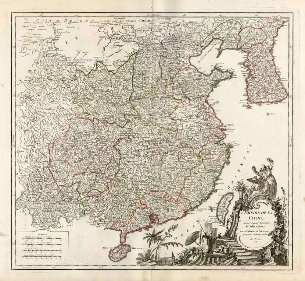
L'Empire de la Chine Dresse d'apres les Cartes de l'Atlas Chinois ... c. 1757
China, by Robert de Vaugondy.
[Item number: 5093]
With Korea as an island.
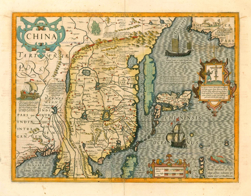
China 1619
China, Korea and Japan by J. Hondius.
[Item number: 6494]

In rare original colour
L'Île de Formosa ou sont exactement marquez les Bancs de Sables, Rochers et Brasses d'Eau. 1713
Formosa and the Pescadores, by Pieter van der Aa.
[Item number: 26098]
In rare old colour
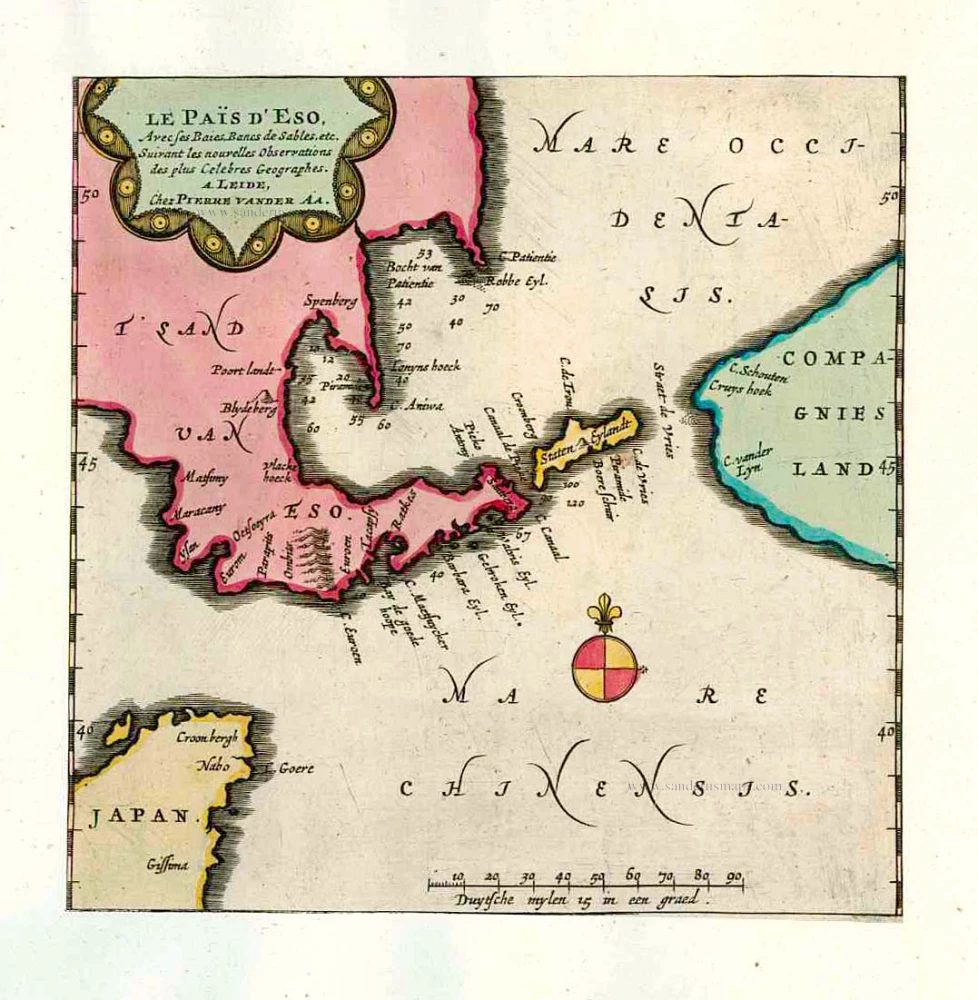
Le Païs d'Eso, Avec ses Baies, Bancs de Sables, etc. 1713
Eso (Hokkaido), by Pieter van der Aa.
[Item number: 26122]

In rare old colour
Les Ports et Havres de Firando et Nangesaque. 1713
Nagasaki and Hirado, by Pieter Van der Aa.
[Item number: 26123]

Early 1525 edition
Ta. Superioris Indiae et Tartariae Maioris. 1525
China - Japan, by Lorenz Fries after Martin Waldseemüller.
[Item number: 27928]

Carte du Katay, ou Empire de Kin. 1750
China - Korea by Jacques Nicolas Bellin.
[Item number: 28177]

Carte de l'Entrée de la Rivière de Canton. 1749
Guangzhou (Canton) by Jacques Nicolas Bellin.
[Item number: 28194]

La Chine avec la Korée et les Parties de la Tartarie les plus voisines, 1749
China - Korea by Jacques Nicolas Bellin.
[Item number: 28195]

Isola del Giapone e Penisola di Corea. 1696
Japan - Korea by Vincenzo Coronelli.
[Item number: 28757]
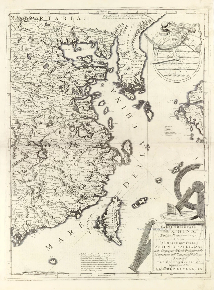
Parte Orientale della China, 1696
Eastern part of China with Korea and Formosa (Taiwan), by Vincenzo Coronelli.
[Item number: 28775]

Very decorative map in excellent condition.
Pecheli, sive Peking Imperii Sinarum Provincia Prima. 1655-1659
Bejing by Joan Blaeu.
[Item number: 29021]

From the Martini atlas
Imperii Sinarum Nova Descriptio. c. 1691-97
China by Joan Blaeu, published by Frederick de Wit.
[Item number: 29431]

First map to show Korea as a peninsula. Excellent condition.
Iaponia Regnum. 1655-1659
Japan & Korea by Joan Blaeu.
[Item number: 29853]

Die Insel Formosa neu abgemessen auf Befehl Kaysers Kamhi. 1726
Taiwan by J. Stöcklein. (Formosa)
[Item number: 30143]

Royaume de la Chine. 1682
China by Nicolas Sanson, published by Simon de Vries.
[Item number: 30235]

L'Empire de la Chine 1748
China by N. Bellin.
[Item number: 30260]

Important and rare China map.
China Regnum. 1593
China by Cornelis de Jode
[Item number: 30312]

Rare 1525 edition in nice old colour.
No title - on verso: Ta. Superioris Indiae et Tartariae Maioris. 1525
China - Japan by Lorenz Fries, after Martin Waldseemüller.
[Item number: 30659]

Rare!
Royaume du Iapon. c. 1658
Japan by Philippe Briet, published by Pierre Mariette.
[Item number: 30911]
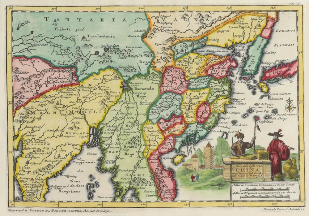
't Koninkryk van China, met d'aangrensende Landen van Siam en Bengale. 1706
China by Pieter Van der Aa.
[Item number: 31842]

Carte du Katay ou Empire de Kin. 1747
Northern China and Korea by Jacques-Nicolas Bellin, published by A.F. Prévost.
[Item number: 31884]

Chinae, Olim Sinarum regionis, nova descriptio. 1584
China by Abraham Ortelius.
[Item number: 32005]

China. 1618
China by Petrus Bertius, published by Jodocus Hondius II.
[Item number: 32151]
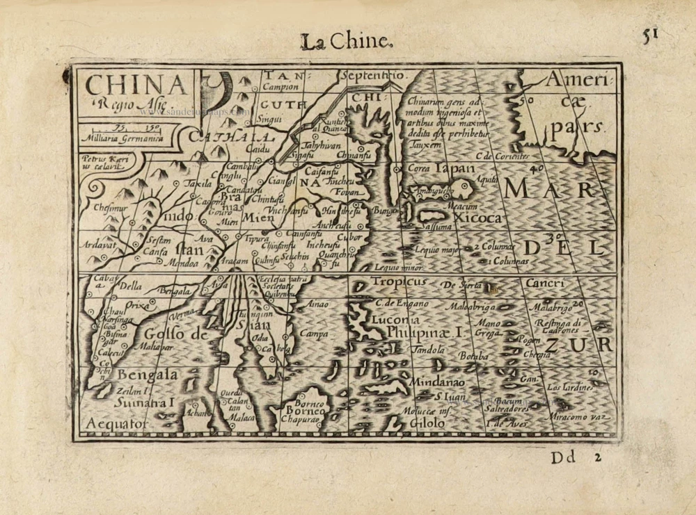
China Regio Asiae. c. 1600
China by Barent Langenes.
[Item number: 32299]

Extremely rare first edition
Mapa de la parte de la Isla Formosa, perteneciente al Emperador de la China sacado por Orden de su Mag. 1753-57
Formosa (Taiwan) by a French missionary, engraved by Gonzalez.
[Item number: 33076]
new