
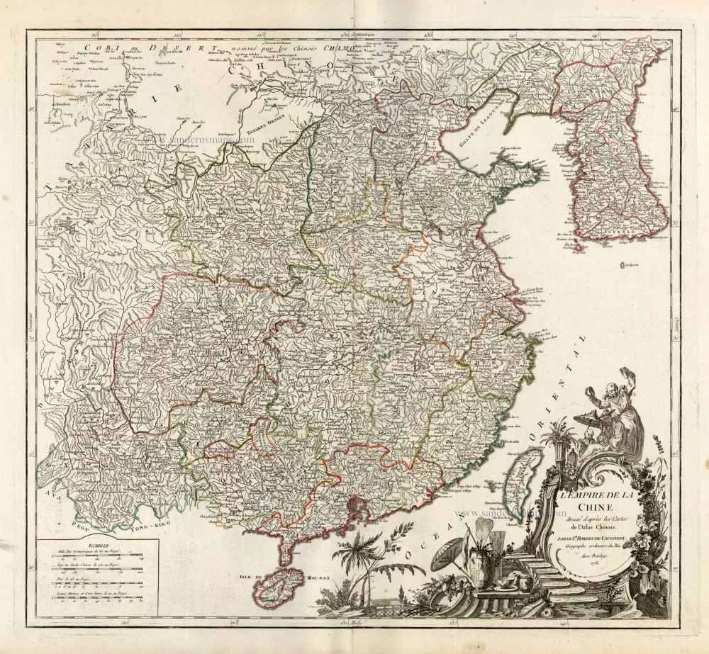
China, by Robert de Vaugondy. c. 1757
Gilles and Didier Robert de Vaugondy
Gilles Robert de Vaugondy (1688-1766) and his son Didier Robert de Vaugondy (1723-1786) were leading cartographers in France during the 18th century. They served both as geographer to the king of France. The father, Gilles is also known as ‘Le Sieur’ or ‘Monsieur Robert’. He descended from the Nicolas Sanson family through Sanson's grandson Pierre Moulard-Sanson, from whom he inherited Sanson's cartographic material. After Hubert Jaillot died in 1712, the de Vaugondy's acquired numerous copies of his maps and plates, which formed the basis of their beautiful Atlas Universel (1757).
Their business flourished from 1731 to 1778. They made a substantial contribution to the world of cartography.
L'Empire de la Chine Dresse d'apres les Cartes de l'Atlas Chinois ...
Item Number: 5093 Authenticity Guarantee
Category: Antique maps > Asia > China
Old, antique map of China by Robert de Vaugondy.
Title: L'Empire de la Chine Dresse d'apres les Cartes de l'Atlas Chinois ...
Date: c. 1757.
Copper engraving, printed on paper.
Size (not including margins): 485 x 530mm (19.09 x 20.87 inches).
Verso: Blank.
Condition: Original outline colour, excellent.
Condition Rating: A.
From: Atlas Universelle. Paris, c.1757.
Gilles and Didier Robert de Vaugondy
Gilles Robert de Vaugondy (1688-1766) and his son Didier Robert de Vaugondy (1723-1786) were leading cartographers in France during the 18th century. They served both as geographer to the king of France. The father, Gilles is also known as ‘Le Sieur’ or ‘Monsieur Robert’. He descended from the Nicolas Sanson family through Sanson's grandson Pierre Moulard-Sanson, from whom he inherited Sanson's cartographic material. After Hubert Jaillot died in 1712, the de Vaugondy's acquired numerous copies of his maps and plates, which formed the basis of their beautiful Atlas Universel (1757).
Their business flourished from 1731 to 1778. They made a substantial contribution to the world of cartography.
Related items

Imperii Sinarum Nova Descriptio. c. 1680.
China with Japan, Korea and Taiwan, by J. Janssonius.
[Item number: 2618]

Pecheli, Xansi, Xantung, Honan, Nanking, In plaga Regni Sinensis in ter Septentrionem ac OrientemCeciam versus sitae Provinciae. c. 1700
Northeastern China, by Valk G. & Schenk P.
[Item number: 2694]
With Korea as an island.
China 1619
China, Korea and Japan by J. Hondius.
[Item number: 6494]
Huquang, Kiangsi, Che Kiang, ac Fokien. Provin: sivae praefecturae Regni Sinen:s, versus Vulturnum, in plaga inter Orientem ac Meridiem media, sitae. c. 1700
Eastern China, by Valk and Schenk.
[Item number: 8453]

In rare original colour
L'Île de Formosa ou sont exactement marquez les Bancs de Sables, Rochers et Brasses d'Eau. 1713
Formosa and the Pescadores, by Pieter van der Aa.
[Item number: 26098]

Huquang, Imperii Sinarum Provincia Septima. 1655-1659
Hukuang (China), by J. Blaeu.
[Item number: 26359]

Quangsi, Sinarum Imperii Provincia Decimatertia. 1655-1659
Kuang-hsi (China), by J. Blaeu.
[Item number: 26361]

Xensi, Imperii Sinarum Provincia Tertia. 1655-1659
China - Shan-hsi (Shensi), by J. Blaeu.
[Item number: 26421]

Carte de l'Entrée de la Rivière de Canton. 1749
Guangzhou (Canton) by Jacques Nicolas Bellin.
[Item number: 28194]

La Chine avec la Korée et les Parties de la Tartarie les plus voisines, 1749
China - Korea by Jacques Nicolas Bellin.
[Item number: 28195]
Parte Orientale della China, 1696
Eastern part of China with Korea and Formosa (Taiwan), by Vincenzo Coronelli.
[Item number: 28775]

Very decorative map in excellent condition.
Pecheli, sive Peking Imperii Sinarum Provincia Prima. 1655-1659
Bejing by Joan Blaeu.
[Item number: 29021]

From the Martini atlas
Imperii Sinarum Nova Descriptio. c. 1691-97
China by Joan Blaeu, published by Frederick de Wit.
[Item number: 29431]

Royaume de la Chine. 1682
China by Nicolas Sanson, published by Simon de Vries.
[Item number: 30235]

L'Empire de la Chine 1748
China by N. Bellin.
[Item number: 30260]

Important and rare China map.
China Regnum. 1593
China by Cornelis de Jode
[Item number: 30312]

SCARCE !
Kuching. 1685/90
View of Tianjin (Tientsin - China), by Carel Allard.
[Item number: 30585]

Rare 1525 edition in nice old colour.
No title - on verso: Ta. Superioris Indiae et Tartariae Maioris. 1525
China - Japan by Lorenz Fries, after Martin Waldseemüller.
[Item number: 30659]
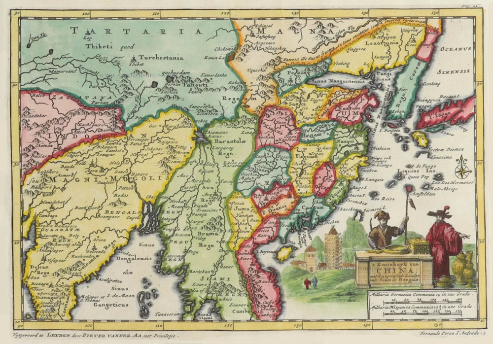
't Koninkryk van China, met d'aangrensende Landen van Siam en Bengale. 1706
China by Pieter Van der Aa.
[Item number: 31842]

Chinae, Olim Sinarum regionis, nova descriptio. 1584
China by Abraham Ortelius.
[Item number: 32005]

China. 1618
China by Petrus Bertius, published by Jodocus Hondius II.
[Item number: 32151]
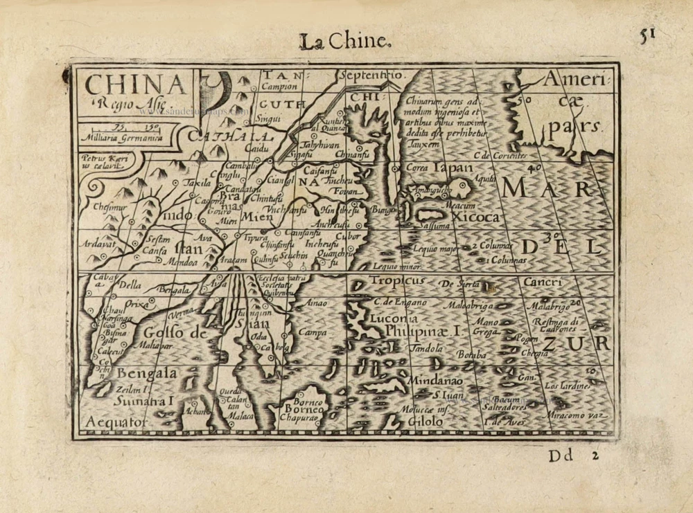
China Regio Asiae. c. 1600
China by Barent Langenes.
[Item number: 32299]