
Guangzhou (Canton) by Jacques Nicolas Bellin. 1749

Jacques-Nicolas Bellin (1703-1772)
Jacques-Nicolas Bellin, a French geographer, was among the most important mapmakers of the eighteenth century. In 1721, at the age of 18, he was appointed hydrographer of the Ministry of the Navy following the French hydrographic office's creation and the Dépot of charts and plans of the Navy. Appointed hydrographic engineer in August 1741. Member of the Academy of the Navy and the Royal Society of London.
Over the course of a 50-year career, he drew the maps of several major works of his time such as Histoire et description générale de la Nouvelle-France de Charlevoix (1744); Histoire générale des voyages de l'Abbé Prévost (published between 1746 and 1759) ); Neptune François (1753), Hydrographie Françoise (1756-1765), and Petit Atlas Français (1763) - reissued as Petit Atlas Maritime (1765). He is the most copied cartographer of the 18th century.
His maps of Canada and the French territories of North America are of considerable value. This is all the more remarkable since, an archetype of the cabinet cartographer, Bellin never came to America. For his cartography of the St. Lawrence River, he entrusted handwritten maps to navigators to correct and enrich. With each return of these maps, he was updating his knowledge. Two basic needs drive its cartography of North America: to secure navigation on the St. Lawrence River and to claim for France the lands explored by the French in the Great Lakes region and along the Mississippi River.
Jacques-Nicolas Bellin died on March 21, 1772, in Versailles. In the burial certificate, he is described as "the first engineer of the navy and the deposit of plans, royal censor of the academy of navy and the royal society of London".
Carte de l'Entrée de la Rivière de Canton.
Item Number: 28194 Authenticity Guarantee
Category: Antique maps > Asia > China
Old, antique map of Guangzhou (Canton), by Jacques Nicolas Bellin.
Title: Carte de l'Entrée de la Rivière de Canton.
Dressée sur les Observations les plus Récentes.
Par N.B. Ingr Ordre de la Marine.
J. v Schley direx.
Kaart van't Inkoomen der Riviere van Kanton, Geschik wolgens de Nieuwste Waarnemingen, door N.B. Ingenieur des Franssen Zeevaards.
Engraver: Jacob van der Schley.
First state.
Date of the first edition: 1749.
Date of this map: 1749.
Copper engraving, printed on paper.
Guangzhou (Canton)
Verso: Blank.
Condition: Folds as issued, excellent.
Condition Rating: A+.
From: Prévost d'Exiles A. Fr. Historische Beschryving der Reizen. Den Haag, P. De Hondt, 1747-80. Enlarged Dutch translation of the French edition of 1746-89. Part 8. 1749.
Jacques-Nicolas Bellin (1703-1772)
Jacques-Nicolas Bellin, a French geographer, was among the most important mapmakers of the eighteenth century. In 1721, at the age of 18, he was appointed hydrographer of the Ministry of the Navy following the French hydrographic office's creation and the Dépot of charts and plans of the Navy. Appointed hydrographic engineer in August 1741. Member of the Academy of the Navy and the Royal Society of London.
Over the course of a 50-year career, he drew the maps of several major works of his time such as Histoire et description générale de la Nouvelle-France de Charlevoix (1744); Histoire générale des voyages de l'Abbé Prévost (published between 1746 and 1759) ); Neptune François (1753), Hydrographie Françoise (1756-1765), and Petit Atlas Français (1763) - reissued as Petit Atlas Maritime (1765). He is the most copied cartographer of the 18th century.
His maps of Canada and the French territories of North America are of considerable value. This is all the more remarkable since, an archetype of the cabinet cartographer, Bellin never came to America. For his cartography of the St. Lawrence River, he entrusted handwritten maps to navigators to correct and enrich. With each return of these maps, he was updating his knowledge. Two basic needs drive its cartography of North America: to secure navigation on the St. Lawrence River and to claim for France the lands explored by the French in the Great Lakes region and along the Mississippi River.
Jacques-Nicolas Bellin died on March 21, 1772, in Versailles. In the burial certificate, he is described as "the first engineer of the navy and the deposit of plans, royal censor of the academy of navy and the royal society of London".
Related items

Imperii Sinarum Nova Descriptio. c. 1680.
China with Japan, Korea and Taiwan, by J. Janssonius.
[Item number: 2618]

Pecheli, Xansi, Xantung, Honan, Nanking, In plaga Regni Sinensis in ter Septentrionem ac OrientemCeciam versus sitae Provinciae. c. 1700
Northeastern China, by Valk G. & Schenk P.
[Item number: 2694]
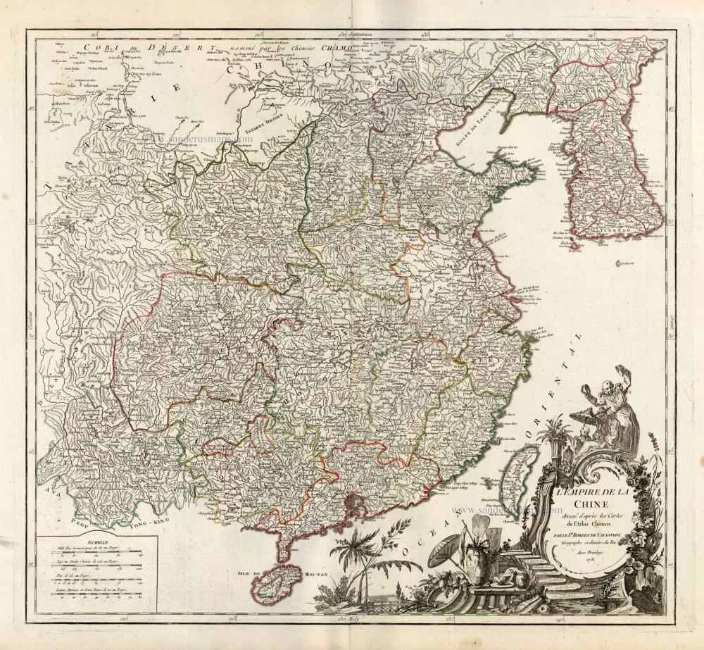
L'Empire de la Chine Dresse d'apres les Cartes de l'Atlas Chinois ... c. 1757
China, by Robert de Vaugondy.
[Item number: 5093]
With Korea as an island.
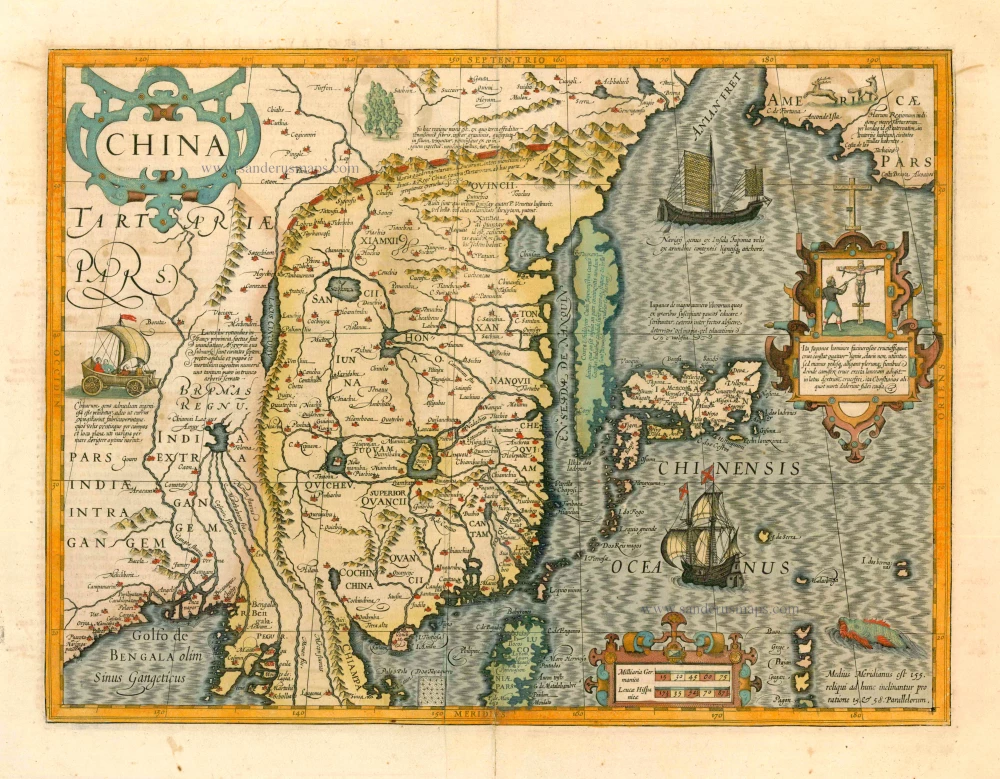
China 1619
China, Korea and Japan by J. Hondius.
[Item number: 6494]
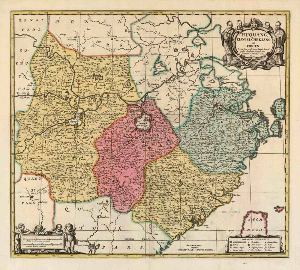
Huquang, Kiangsi, Che Kiang, ac Fokien. Provin: sivae praefecturae Regni Sinen:s, versus Vulturnum, in plaga inter Orientem ac Meridiem media, sitae. c. 1700
Eastern China, by Valk and Schenk.
[Item number: 8453]

Huquang, Imperii Sinarum Provincia Septima. 1655-1659
Hukuang (China), by J. Blaeu.
[Item number: 26359]

L'Empire de la Chine, avec la Tartarie Chinoise d'après l'Atlas Chinois. 1776-79
China with Korea and Japan, by Paolo Santini.
[Item number: 26974]

China Veteribus Sinarum Regio Nunc Incolis Tame Dicta. 1649-55
China - Japan - Korea, by Willem & Joan Blaeu.
[Item number: 27043]

La Chine, Suivant les Nouvelles Observations. 1713
China, by Pieter van der Aa.
[Item number: 27095]

Early 1525 edition
Ta. Superioris Indiae et Tartariae Maioris. 1525
China - Japan, by Lorenz Fries after Martin Waldseemüller.
[Item number: 27928]

Carte du Katay, ou Empire de Kin. 1750
China - Korea by Jacques Nicolas Bellin.
[Item number: 28177]