
China by Abraham Ortelius. 1584


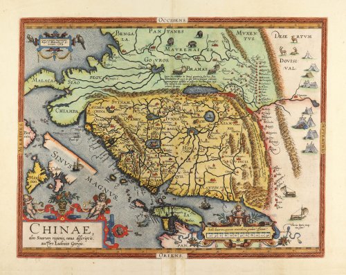

The first printed map of China. Signed by Ludovico Georgio (= Luiz Jorge de Barbuda, a Portuguese Jesuit), who made a manuscript map of China which reached Ortelius via Arias Montanus (Meurer p.111-112).
Abraham Ortelius (1527-1598)
The maker of the 'first atlas', the Theatrum Orbis Terrarum (1570), was born on 4 April 1527 into an old Antwerp family. He learned Latin and studied Greek and mathematics.
Abraham and his sisters, Anne and Elizabeth, took up map colouring. Ortelius was admitted to the Guild of St. Luke as an "illuminator of maps." In addition to colouring maps, Ortelius was a dealer in antiques, coins, maps, and books, and the book and map trade gradually became his primary occupation.
Business went well because his means allowed him to amass an extensive collection of medals, coins, and antiques, as well as a library of many volumes. In addition, he travelled extensively, visited Italy and France, made contacts with scholars and editors everywhere, and maintained extensive correspondence with them.
In 1564, he published his first map, a large and ambitious world wall map. The inspiration for this map may well have been Gastaldi's large world map. In 1565, he published a map of Egypt and a map of the Holy Land; a large map of Asia followed.
In 1568, the production of individual maps for his atlas Theatrum Orbis Terrarum was already in full swing. He completed the atlas in 1569, and in May 1570, it was available for sale. It was one of the most expensive books ever published.
This first edition contained seventy maps on fifty-three sheets. Franciscus Hogenberg engraved the maps.
Later editions included Additamenta (additions), resulting in Ortelius' historical atlas, the Parergon, which is mainly bound together with the atlas. The Parergon can be considered a truly original work by Ortelius, who drew the maps based on his research.
The importance of the Theatrum Orbis Terrarum for geographical knowledge in the last quarter of the sixteenth century is difficult to overemphasise. Nothing was like it until Mercator's atlas appeared twenty-five years later. Demand for the Theatrum was remarkable. Some 24 editions appeared during Ortelius's lifetime, and another 10 after he died in 1598. Editions were published in Dutch, German, French, Spanish, English, and Italian. The number of map sheets grew from 53 in 1570 to 167 in the last edition in 1612.
In 1577, engraver Philip Galle and poet-translator Pieter Heyns published the first pocket-sized edition of the Theatrum, the Epitome. The work was trendy. Over thirty editions of this Epitome were published in different languages.
Ortelius is also remembered for an early idea resembling continental drift: he suggested that the Americas, Europe, and Africa may once have been joined together before separating over time. His work helped shape the development of modern geography and mapmaking.
Chinae, Olim Sinarum regionis, nova descriptio.
Item Number: 32005 Authenticity Guarantee
Category: Antique maps > Asia > China
China by Abraham Ortelius.
Title: Chinae, Olim Sinarum regionis, nova descriptio.
auctore Ludovico Georgio.
Cum privilegio Imperatoris, Regis, & Brabantiae: ad decennium, 1584.
Oriented to the west.
Cartographer: Luiz Jorge de Barbuda.
Date of the first edition: 1584.
Date of this map: 1584.
Date on map: 1584.
First state.
Copper engraving, printed on paper.
Image size: 370 x 470mm (14½ x 18½ inches).
Sheet size: 425 x 560mm (16¾ x 22 inches).
Verso: Latin text.
Condition: Original coloured and heightened in gold; lower centrefold split reinforced (outside the image).
Condition Rating: A+.
From: Theatrum Orbis Terrarum. Antwerp, Christoffel Plantin, 1584. (Van der Krogt, 31:031)
The first printed map of China. Signed by Ludovico Georgio (= Luiz Jorge de Barbuda, a Portuguese Jesuit), who made a manuscript map of China which reached Ortelius via Arias Montanus (Meurer p.111-112).
Abraham Ortelius (1527-1598)
The maker of the 'first atlas', the Theatrum Orbis Terrarum (1570), was born on 4 April 1527 into an old Antwerp family. He learned Latin and studied Greek and mathematics.
Abraham and his sisters, Anne and Elizabeth, took up map colouring. Ortelius was admitted to the Guild of St. Luke as an "illuminator of maps." In addition to colouring maps, Ortelius was a dealer in antiques, coins, maps, and books, and the book and map trade gradually became his primary occupation.
Business went well because his means allowed him to amass an extensive collection of medals, coins, and antiques, as well as a library of many volumes. In addition, he travelled extensively, visited Italy and France, made contacts with scholars and editors everywhere, and maintained extensive correspondence with them.
In 1564, he published his first map, a large and ambitious world wall map. The inspiration for this map may well have been Gastaldi's large world map. In 1565, he published a map of Egypt and a map of the Holy Land; a large map of Asia followed.
In 1568, the production of individual maps for his atlas Theatrum Orbis Terrarum was already in full swing. He completed the atlas in 1569, and in May 1570, it was available for sale. It was one of the most expensive books ever published.
This first edition contained seventy maps on fifty-three sheets. Franciscus Hogenberg engraved the maps.
Later editions included Additamenta (additions), resulting in Ortelius' historical atlas, the Parergon, which is mainly bound together with the atlas. The Parergon can be considered a truly original work by Ortelius, who drew the maps based on his research.
The importance of the Theatrum Orbis Terrarum for geographical knowledge in the last quarter of the sixteenth century is difficult to overemphasise. Nothing was like it until Mercator's atlas appeared twenty-five years later. Demand for the Theatrum was remarkable. Some 24 editions appeared during Ortelius's lifetime, and another 10 after he died in 1598. Editions were published in Dutch, German, French, Spanish, English, and Italian. The number of map sheets grew from 53 in 1570 to 167 in the last edition in 1612.
In 1577, engraver Philip Galle and poet-translator Pieter Heyns published the first pocket-sized edition of the Theatrum, the Epitome. The work was trendy. Over thirty editions of this Epitome were published in different languages.
Ortelius is also remembered for an early idea resembling continental drift: he suggested that the Americas, Europe, and Africa may once have been joined together before separating over time. His work helped shape the development of modern geography and mapmaking.
Related items

Imperii Sinarum Nova Descriptio. c. 1680.
China with Japan, Korea and Taiwan, by J. Janssonius.
[Item number: 2618]
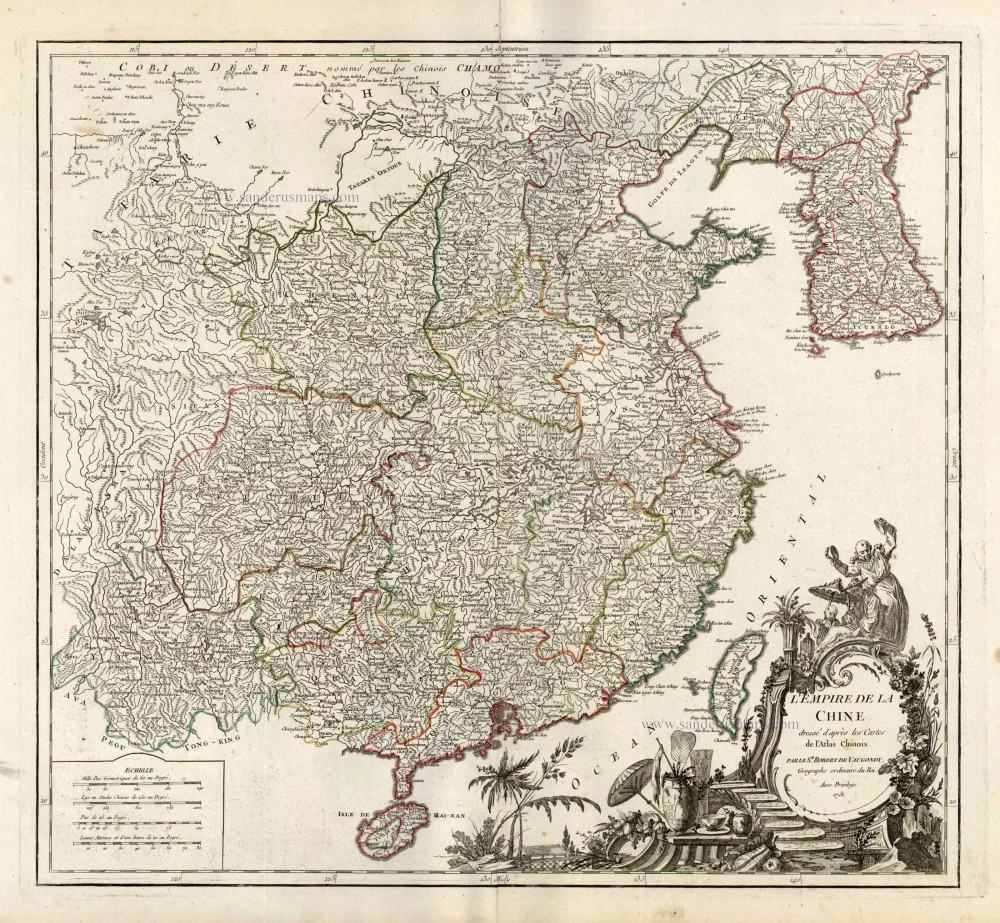
L'Empire de la Chine Dresse d'apres les Cartes de l'Atlas Chinois ... c. 1757
China, by Robert de Vaugondy.
[Item number: 5093]
With Korea as an island.
China 1619
China, Korea and Japan by J. Hondius.
[Item number: 6494]
China. 1641
China, Japan, Korea by Henricus Hondius.
[Item number: 26440]

L'Empire de la Chine, avec la Tartarie Chinoise d'après l'Atlas Chinois. 1776-79
China with Korea and Japan, by Paolo Santini.
[Item number: 26974]

China Veteribus Sinarum Regio Nunc Incolis Tame Dicta. 1649-55
China - Japan - Korea, by Willem & Joan Blaeu.
[Item number: 27043]

La Chine, Suivant les Nouvelles Observations. 1713
China, by Pieter van der Aa.
[Item number: 27095]

Early 1525 edition
Ta. Superioris Indiae et Tartariae Maioris. 1525
China - Japan, by Lorenz Fries after Martin Waldseemüller.
[Item number: 27928]

Carte du Katay, ou Empire de Kin. 1750
China - Korea by Jacques Nicolas Bellin.
[Item number: 28177]

La Chine avec la Korée et les Parties de la Tartarie les plus voisines, 1749
China - Korea by Jacques Nicolas Bellin.
[Item number: 28195]

Honan, Imperii Sinarum Provincia Quinta. 1655-1659
Honan by Joan Blaeu
[Item number: 28593]

From the Martini atlas
Imperii Sinarum Nova Descriptio. c. 1691-97
China by Joan Blaeu, published by Frederick de Wit.
[Item number: 29431]

Royaume de la Chine. 1682
China by Nicolas Sanson, published by Simon de Vries.
[Item number: 30235]

L'Empire de la Chine 1748
China by N. Bellin.
[Item number: 30260]

Important and rare China map.
China Regnum. 1593
China by Cornelis de Jode
[Item number: 30312]

Rare 1525 edition in nice old colour.
No title - on verso: Ta. Superioris Indiae et Tartariae Maioris. 1525
China - Japan by Lorenz Fries, after Martin Waldseemüller.
[Item number: 30659]
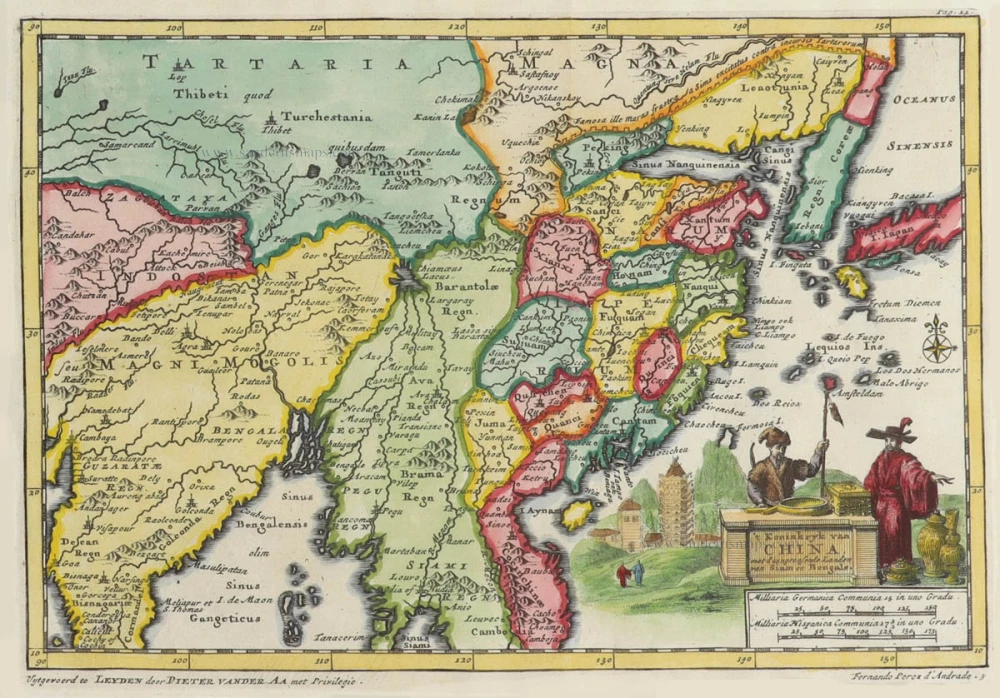
't Koninkryk van China, met d'aangrensende Landen van Siam en Bengale. 1706
China by Pieter Van der Aa.
[Item number: 31842]

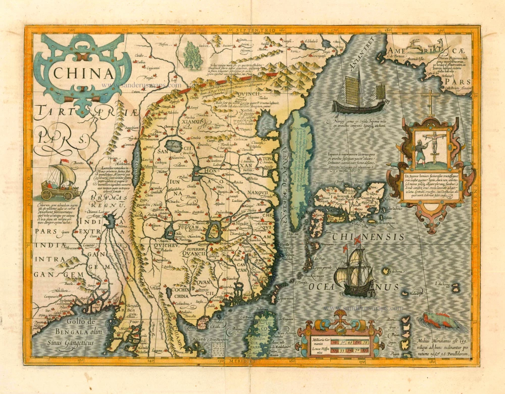
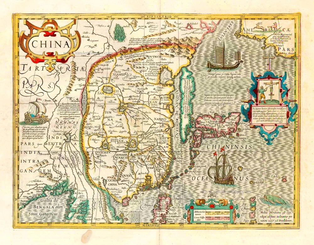
China. 1618
China by Petrus Bertius, published by Jodocus Hondius II.
[Item number: 32151]
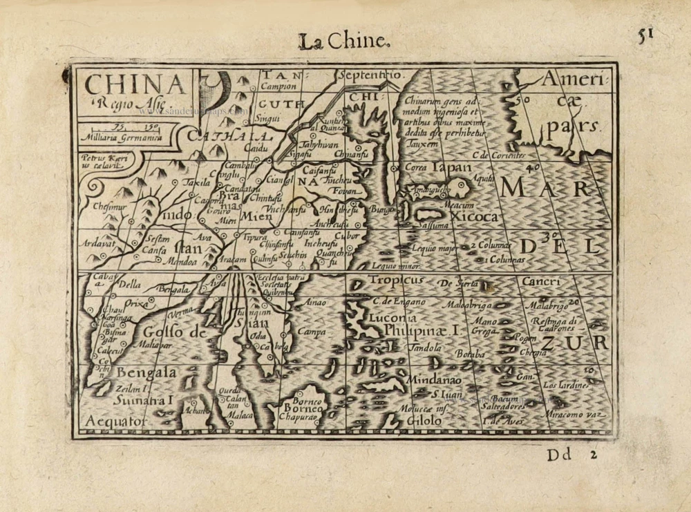
China Regio Asiae. c. 1600
China by Barent Langenes.
[Item number: 32299]