
Extremely rare map, only one complete copy recorded
Map depicting Jerusalem and the Holy Land, by Nicolas van Aelst. 1590
According to Bifolco-Ronca (Cartografia e Topografia Italiana del XVI secolo), only one complete copy of this map is recorded: Rome, Bibliotheca Apostolica Vaticana. Only the right part of this map (described by Laor) is in the National Library of Israel.
Another copy, kept in an atlas factice, was sold at Christie's New York in 2011. The atlas was later apparently sold as loose maps.
Nicolas van Aelst (c. 1527 - 1613)
Flemish printseller and engraver resident at '5 Maire della Pace', Rome.
He obtained several printing privileges from Sixtus V for prints of monuments built or restored by the pope himself. He published engravings from drawings by the best artists, including Antonio Tempesta. Van Aelst owned a rich collection of copper plates he engraved or purchased from other publishers, including some that belonged to Lafreri. In choosing subjects, he preferred geographical maps and prints of ancient and modern monuments, leaving aside religious subjects.
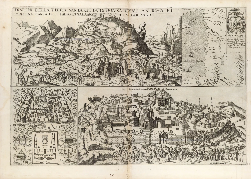
Disegni della Terra Santa Citta di Ierusalemme Anticha et Moderna Pianta di Salomone et D'Altri Luoghi Santi.
Item Number: 31414 Authenticity Guarantee
Category: Antique maps > Asia > Holy Land
Map depicting Jerusalem and the sacred places of the Holy Land, by Nicolas van Aelst.
Title: Disegni della Terra Santa Citta di Ierusalemme Anticha et Moderna Pianta di Salomone et D'Altri Luoghi Santi.
Nicolas van aelst de Brusselles ded.
Romae cum privilegio.
Map in four sections: Upper left: The Mount of Olives with the general title. Upper right: Map of the Holy Land with a dedication to Girolamo d'Avila by Nicolas van Aelst. Lower left: Plan of antique Jerusalem and Solomon's Temple. Lower right: View on Jerusalem from the east with title: Ierusalem Ritratta con parte del suo circuito che hoggidi si vede dalla parte d'orient.
Date: 1590.
Copper engraving, printed on paper.
Image size: 460 x 690mm (18 x 27¼ inches).
Sheet size: 530 x 735mm (20¾ x 29 inches).
Verso: Blank.
Condition: some browning along centrefold, small worm trace in centre and small tear backed. Printed from two plates, joined.
Condition Rating: A.
Separate publication.
According to Bifolco-Ronca (Cartografia e Topografia Italiana del XVI secolo), only one complete copy of this map is recorded: Rome, Bibliotheca Apostolica Vaticana. Only the right part of this map (described by Laor) is in the National Library of Israel.
Another copy, kept in an atlas factice, was sold at Christie's New York in 2011. The atlas was later apparently sold as loose maps.
Nicolas van Aelst (c. 1527 - 1613)
Flemish printseller and engraver resident at '5 Maire della Pace', Rome.
He obtained several printing privileges from Sixtus V for prints of monuments built or restored by the pope himself. He published engravings from drawings by the best artists, including Antonio Tempesta. Van Aelst owned a rich collection of copper plates he engraved or purchased from other publishers, including some that belonged to Lafreri. In choosing subjects, he preferred geographical maps and prints of ancient and modern monuments, leaving aside religious subjects.
Related items

Terra Sancta quae in Sacris Terra Promissionis ol: Palestina 1630
HOLY LAND by Mercator - Janssonius
[Item number: 17710]
Hierosolyma, Clarissima Totius Orientis Civitas Iudaee Metropolis ... 1599
Jerusalem, by Georg Braun and Frans Hogenberg.
[Item number: 23948]
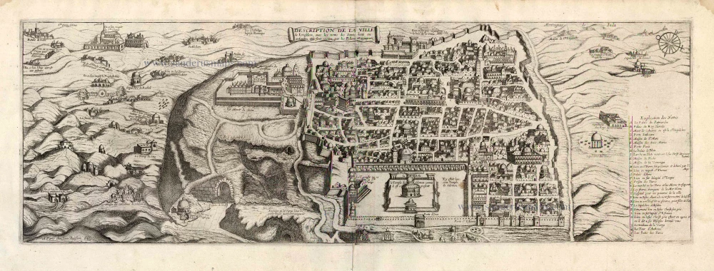
Description de la Ville de Jerusalem avec les Noms des Saints Lieux ou Antiquitez qui sont Visitez par les Pellerins et Voiageurs. 1648
Jerusalem by J. Boisseau.
[Item number: 25598]

La saincte cité de Ierusalem iadiz metropolitaine du royaume des Iuifz, & maintenant colonie du Turc. 1552
Jerusalem, by Sebastian Munster.
[Item number: 27359]

Ierusalem comme elle est a present. c. 1780
Jerusalem by Pierre Aveline.
[Item number: 28752]

Hierosolyma Urbs Sancta, Iudeae, Totiusque Orientis Longe Clarissima ... 1623
Jerusalem, by Georg Braun & Frans Hogenberg
[Item number: 29229]

Vue & Description de la ville de Jerusalem telle qu'elle est aujourd'hui avec les tombeaux de ses anciens rois, & quelques autres antiquités curieuses qui se trouvent aux environs de cette ville. 1719
Jerusalem, by Z. Châtelain
[Item number: 29374]

Palestinae Delineatio Ad Geographiae Canones Revocata. 1641
Holy Land - Jerusalem by Philippe Briet, published by Pierre Mariette.
[Item number: 30056]

Pinax Geogpaphicus [sic] Patriarchatus Hierosolymitani [...] 1651
The Patriarchate of Jerusalem, by Philippe de la Rue, published by Pierre Mariette.
[Item number: 30120]

La saincte cité de Ierusalem iadiz metropolitaine du royaume des Iuifz, & maintenant colonie du Turc. 1568
Jerusalem, by Sebastian Munster.
[Item number: 30601]

Tabula Cananaeae prout tempore Christi et Apostolorum divisa fuit 1618
Holy Land by Petrus Bertius, published by Jodocus Hondius II.
[Item number: 32140]

Iudaea seu Palaestina ob Sacratißima Redemtoris vestigia hodie dicta Terra Sancta prout olim in Duodecim Tribus Divisa separatis ab Invicem Regnis Iuda et Israel expreßis insuper VI ultimi temporis ejusdem Terrae Procinciis. c. 1720
Holy Land, by J.B. Homann.
[Item number: 32192]

First edition!
Ierusalem, et Suburbia eius, sicut Tempore Christi Floruit, cum Locis in quibus Christ Pass. est quae religiose à Christianis observata etiam num Veneratio ni habent descripta per Christianum Adrichom Delphum Delphum. 1588
Jerusalem by Georg Braun and Frans Hogenberg.
[Item number: 32830]

Terra Sancta sive Promissionis, olim Palestina, in duo divisa Regna, Israel, et Iuda, et in sex subdivisa Provincias ... 1687
Holy Land, by Guillaume Sanson, adapted by Giacomo Cantelli da Vignola, and published by Giovanni de Rossi.
[Item number: 32957]