
Holy Land, by J.B. Homann. c. 1720

The Homann Family: Masters of German Cartography and Publishing
The Homann family stands as one of the most significant names in the history of German cartography and publishing. Their maps, atlases, and geographic works not only shaped contemporary understanding of the world during the 18th century but also left an enduring legacy in the fields of geography, engraving, and scholarly publishing.
The family's prominence began with Johann Baptist Homann (1664–1724), a native of Oberkammlach in Bavaria. Initially trained in law and theology, Johann Baptist later turned to engraving and cartography — a field that was flourishing amid the Age of Discovery and the growing demand for precise geographic knowledge.
In 1702, he founded his own publishing house in Nürnberg, a city then renowned for its vibrant intellectual, artistic, and scientific community. Nuremberg’s rich tradition of printmaking and map production provided fertile ground for Homann's enterprise.
Johann Baptist Homann quickly rose to prominence as one of Germany’s leading cartographers and publishers. His works combined technical accuracy, artistic merit, and rich ornamentation, often embellished with elaborate cartouches, mythological scenes, and heraldic symbols.
In 1715, Homann was appointed Imperial Geographer to the Holy Roman Emperor Charles VI. He obtained the "Imperial Privilege" (Privilegium Imperialis). This prestigious title solidified his status and bestowed upon his publishing house both credibility and influence. His most famous works include:
- Atlas Novus Terrarum Orbis (1707) — an early and ambitious atlas project.
- Grosser Atlas über die ganze Welt (1716) — one of the most crucial German world atlases of the early 18th century.
Homann’s maps covered both European and global territories, including the Americas, Asia, and Africa, reflecting contemporary geographical knowledge and political boundaries.
The Homann Heirs (Homannische Erben)
After Johann Baptist Homann died in 1724, his son Johann Christoph Homann (1703–1730) briefly took over the business. However, Johann Christoph died at a young age, and the enterprise was then continued under the name Homännische Erben ("Homann Heirs"), a partnership of family members and associates.
Despite the loss of its founder, the firm remained highly productive and influential for several decades. The Homann Heirs continued to publish atlases, wall maps, city views, and geographical treatises well into the late 18th century. Their catalogue included works by noted cartographers such as Johann Matthias Hase, Leonhard Euler, and Tobias Conrad Lotter.
The Homann publishing house played a crucial role in disseminating geographic and scientific knowledge during the Enlightenment. Their maps combined artistry with empirical detail and were sought after by scholars, navigators, governments, and collectors.
Several of their works are now prized as valuable historical artefacts, housed in museums, libraries, and private collections around the world. The Homann Heirs' firm gradually declined by the end of the 18th century, overtaken by newer publishing houses and changing technologies, but their contribution to the cartographic tradition remains significant.
The Homann family’s name is indelibly linked to the golden age of German cartography. Through meticulous craftsmanship and a keen sense of visual storytelling, they charted the known world of their time, leaving a remarkable record of early modern geography. Today, their maps not only inform historians of cartography but also captivate collectors and enthusiasts for their aesthetic beauty and historical value.
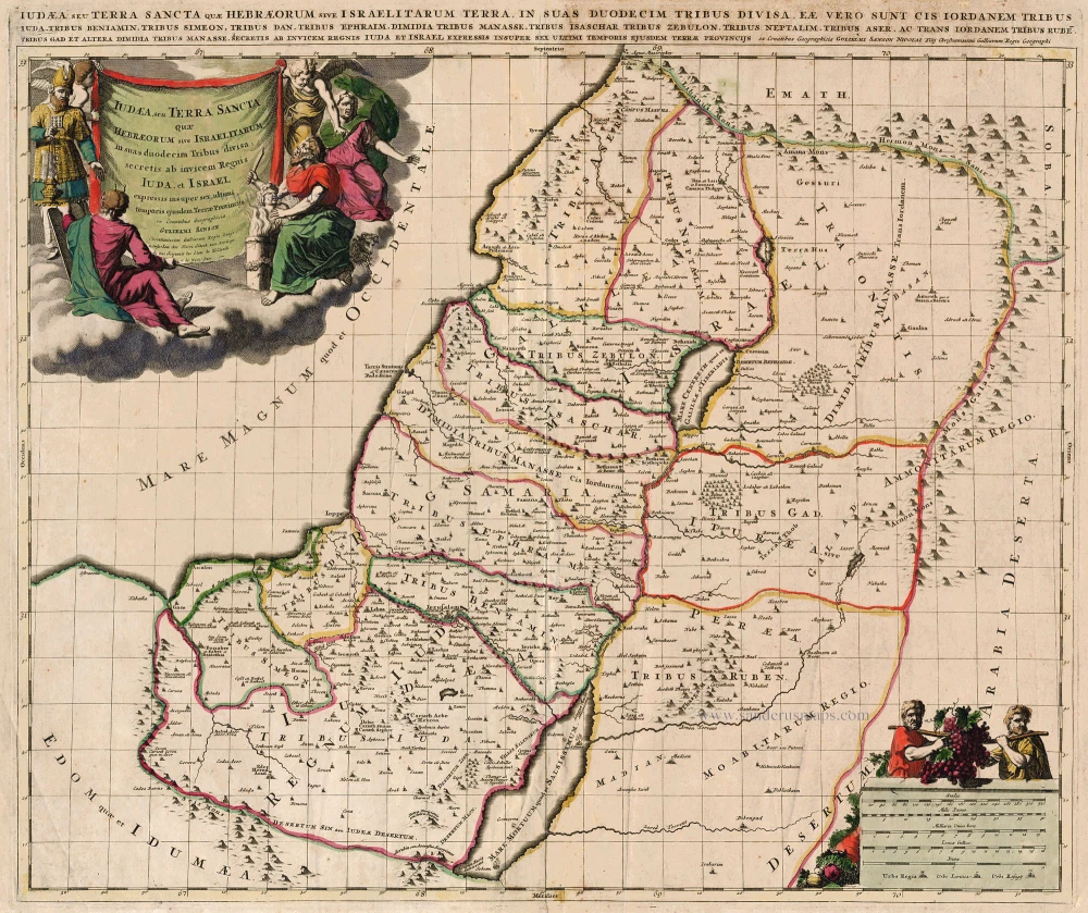
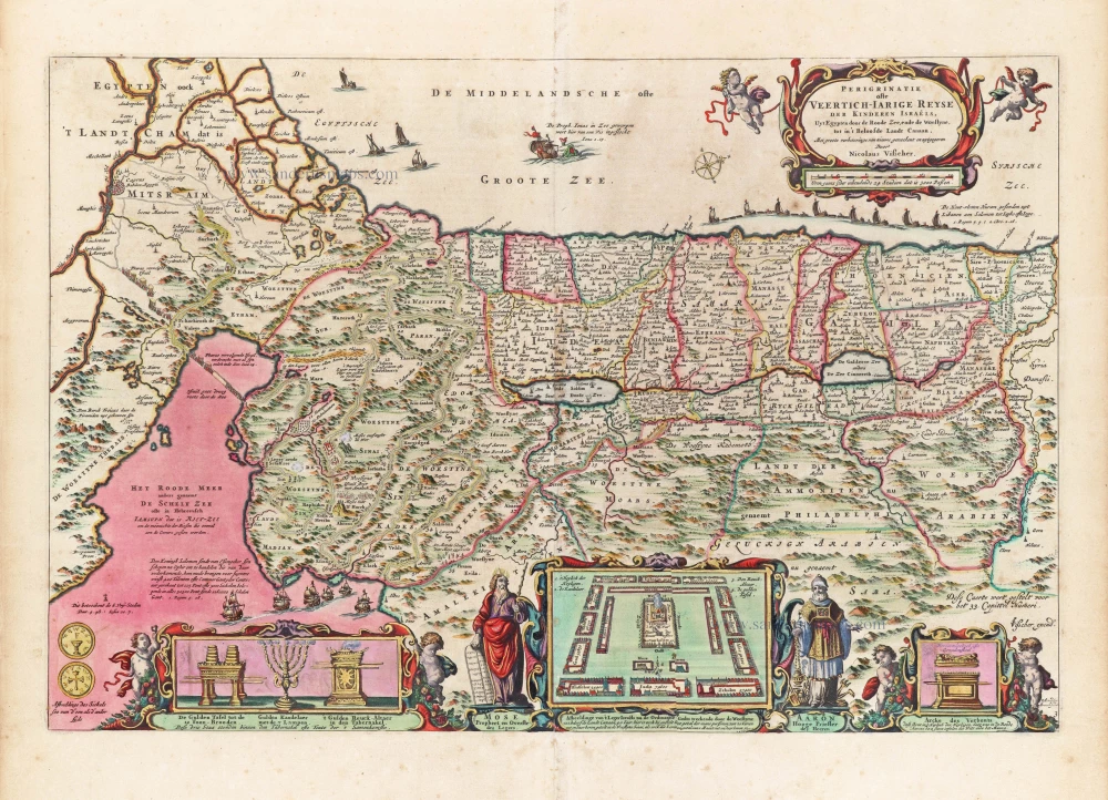
Iudaea seu Palaestina ob Sacratißima Redemtoris vestigia hodie dicta Terra Sancta prout olim in Duodecim Tribus Divisa separatis ab Invicem Regnis Iuda et Israel expreßis insuper VI ultimi temporis ejusdem Terrae Procinciis.
Item Number: 32192 Authenticity Guarantee
Category: Antique maps > Asia > Holy Land
Holy Land, by J.B. Homann.
Title: Iudaea seu Palaestina ob Sacratißima Redemtoris vestigia hodie dicta Terra Sancta prout olim in Duodecim Tribus Divisa separatis ab Invicem Regnis Iuda et Israel expreßis insuper VI ultimi temporis ejusdem Terrae Procinciis.
collecta ex Tabulis Guil. Sansonij Christ. Regis Geogr. à Ioh. Baptista Homanno Norimbergae.
Date of the first edition: 1707.
Date of this map: c. 1720.
Copper engraving, printed on paper.
Image size: 485 x 570mm (19 x 22½ inches).
Sheet size: 515 x 600mm (20¼ x 23½ inches).
Verso: Blank.
Condition: Original coloured, sharp impression, excellent.
Condition Rating: A+.
From: Atlas Novus Terrarum Orbis Imperia, regna et status exactis tabulis geographice demonstrans. Nuremberg, J.B. Homann, [c. 1720].
The Homann Family: Masters of German Cartography and Publishing
The Homann family stands as one of the most significant names in the history of German cartography and publishing. Their maps, atlases, and geographic works not only shaped contemporary understanding of the world during the 18th century but also left an enduring legacy in the fields of geography, engraving, and scholarly publishing.
The family's prominence began with Johann Baptist Homann (1664–1724), a native of Oberkammlach in Bavaria. Initially trained in law and theology, Johann Baptist later turned to engraving and cartography — a field that was flourishing amid the Age of Discovery and the growing demand for precise geographic knowledge.
In 1702, he founded his own publishing house in Nürnberg, a city then renowned for its vibrant intellectual, artistic, and scientific community. Nuremberg’s rich tradition of printmaking and map production provided fertile ground for Homann's enterprise.
Johann Baptist Homann quickly rose to prominence as one of Germany’s leading cartographers and publishers. His works combined technical accuracy, artistic merit, and rich ornamentation, often embellished with elaborate cartouches, mythological scenes, and heraldic symbols.
In 1715, Homann was appointed Imperial Geographer to the Holy Roman Emperor Charles VI. He obtained the "Imperial Privilege" (Privilegium Imperialis). This prestigious title solidified his status and bestowed upon his publishing house both credibility and influence. His most famous works include:
- Atlas Novus Terrarum Orbis (1707) — an early and ambitious atlas project.
- Grosser Atlas über die ganze Welt (1716) — one of the most crucial German world atlases of the early 18th century.
Homann’s maps covered both European and global territories, including the Americas, Asia, and Africa, reflecting contemporary geographical knowledge and political boundaries.
The Homann Heirs (Homannische Erben)
After Johann Baptist Homann died in 1724, his son Johann Christoph Homann (1703–1730) briefly took over the business. However, Johann Christoph died at a young age, and the enterprise was then continued under the name Homännische Erben ("Homann Heirs"), a partnership of family members and associates.
Despite the loss of its founder, the firm remained highly productive and influential for several decades. The Homann Heirs continued to publish atlases, wall maps, city views, and geographical treatises well into the late 18th century. Their catalogue included works by noted cartographers such as Johann Matthias Hase, Leonhard Euler, and Tobias Conrad Lotter.
The Homann publishing house played a crucial role in disseminating geographic and scientific knowledge during the Enlightenment. Their maps combined artistry with empirical detail and were sought after by scholars, navigators, governments, and collectors.
Several of their works are now prized as valuable historical artefacts, housed in museums, libraries, and private collections around the world. The Homann Heirs' firm gradually declined by the end of the 18th century, overtaken by newer publishing houses and changing technologies, but their contribution to the cartographic tradition remains significant.
The Homann family’s name is indelibly linked to the golden age of German cartography. Through meticulous craftsmanship and a keen sense of visual storytelling, they charted the known world of their time, leaving a remarkable record of early modern geography. Today, their maps not only inform historians of cartography but also captivate collectors and enthusiasts for their aesthetic beauty and historical value.
Related items

Palaestinae sive totius Terrae Promissionis nova descriptio Auctore Tilemanno Stella Sigenensi. 1624
Holy Land, by Abraham Ortelius.
[Item number: 1583]

Tribus Zabulon, Isachar, Et, Dimidia Manasse ... 1590
Holy Land, by Adrichomius C.
[Item number: 1902]

Vue et Description de Bethleem et de Nazareth et de Plusieurs Singularitez Curieuses .. 1719
Holy Land - Bethlehem - Nazareth, by Z. Châtelain.
[Item number: 16855]

Terra Sancta quae in Sacris Terra Promissionis ol: Palestina 1630
HOLY LAND by Mercator - Janssonius
[Item number: 17710]

Beschreibung des Heiligen Landes Canaan. 1581
The Holy Land, by Bünting H.
[Item number: 18420]
Iudaea, seu Terra Sancta quae Hebraeorum sive Israelitarum ... c. 1700
HOLY LAND by Schenk P.
[Item number: 19146]

Situs Terrae Promissionis. S.S. Bibliorum intelligentiam exacte aperiens per Chr. Adrichom. c. 1658
The Holy Land, by Janssonius J.
[Item number: 19521]
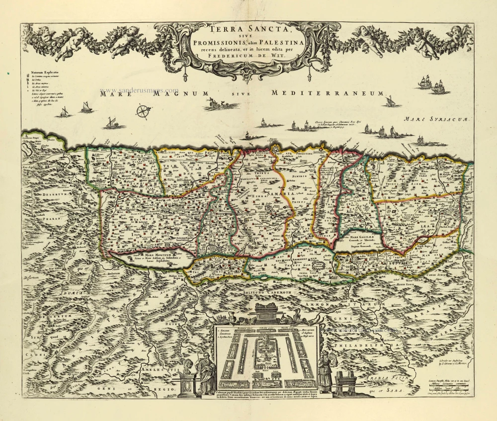
Terra Sancta, sive Promissionis, olim Palestina recens delineata. 1683-1696
The Holy Land, by Visscher N.
[Item number: 19522]

Reisen der Kinder von Israel aus Egypten. 1582
Holy Land - Egypt by Heinrich Bünting.
[Item number: 22612]

Taffel des Heiligen Landes zu dem Newen Testament dienlich. 1582
Holy Land, by Bünting H.
[Item number: 22640]

Terra Sancta, A Petro Laicstain perlustrata, et ab eius ore et schedisà Chistino Schrot in tabulam redacta. 1612
Holy Land by Abraham Ortelius.
[Item number: 23099]

Situs Terrae Canaan sive Terrae Promissionis, hodie Palestinae, ... 1710
The Holy Land, by Jaillot - Covens & Mortier.
[Item number: 23600]

Terra Sancta, sive Promissionis, olim Palestina recens delineata. 1683-1696
The Holy Land by Nicolaas Visscher
[Item number: 24441]
Tabula Asiae IIII. 1571
Middle East - Cyprus - Holy Land by Strabo - Sebastian Münster
[Item number: 25653]

Terre Sainte Suivant les Nouvelles Observations. 1713
The Holy Land, by Pieter van der Aa.
[Item number: 26110]

La Judée ou Terre Sainte divisée en ses Douze Tribus. 1776-79
Holy Land, by Paolo Santini.
[Item number: 27015]
In monte Casio iuxta Ostracinam, ... 1550
Cyprus and the Holy Land, by Sebastian Münster.
[Item number: 27073]
Terra Sancta, sive Promissionis, olim Palestina. after 1721
Holy Land by Frederik de Wit, published by Covens & Mortier.
[Item number: 28329]

Terra Sancta, sive Promissionis, olim Palestina recens delineata. 1664-80
The Holy Land by Nicolaas Visscher.
[Item number: 28582]

Terra Sancta, A Petro Laicstain perlustrata, et ab eius ore et schedisà Chistino Schrot in tabulam redacta. 1601
Holy Land by Abraham Ortelius.
[Item number: 28669]
Parergon map
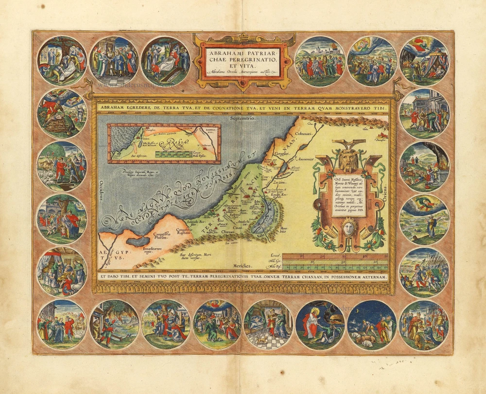
Abrahami Patriarchae Peregrinatio, et Vita. 1612
The Holy Land by Abraham Ortelius.
[Item number: 28921]

First edition
Creta Iovis magni, medio iacet insula ponto. [On sheet with:] Corsica [and:] Insulae Maris Ionii [and:] Sardinia. 1584
Corsica, Crete (Creta), Sardinia, by Abraham Ortelius.
[Item number: 29148]

Carte de la Terre Sainte Divisée dans Toutes ses Parties selon le nombre des Tribus d'Israel. 1719
Holy Land, by Zacharias Châtelain.
[Item number: 29383]

The most decorative map of the Holy Land to be included in a seventeenth century atlas
Palestina, sive Terrae Sanctae Descriptio. 1666
The Holy Land by Joannes Janssonius.
[Item number: 29972]

Palestinae Delineatio Ad Geographiae Canones Revocata. 1641
Holy Land - Jerusalem by Philippe Briet, published by Pierre Mariette.
[Item number: 30056]
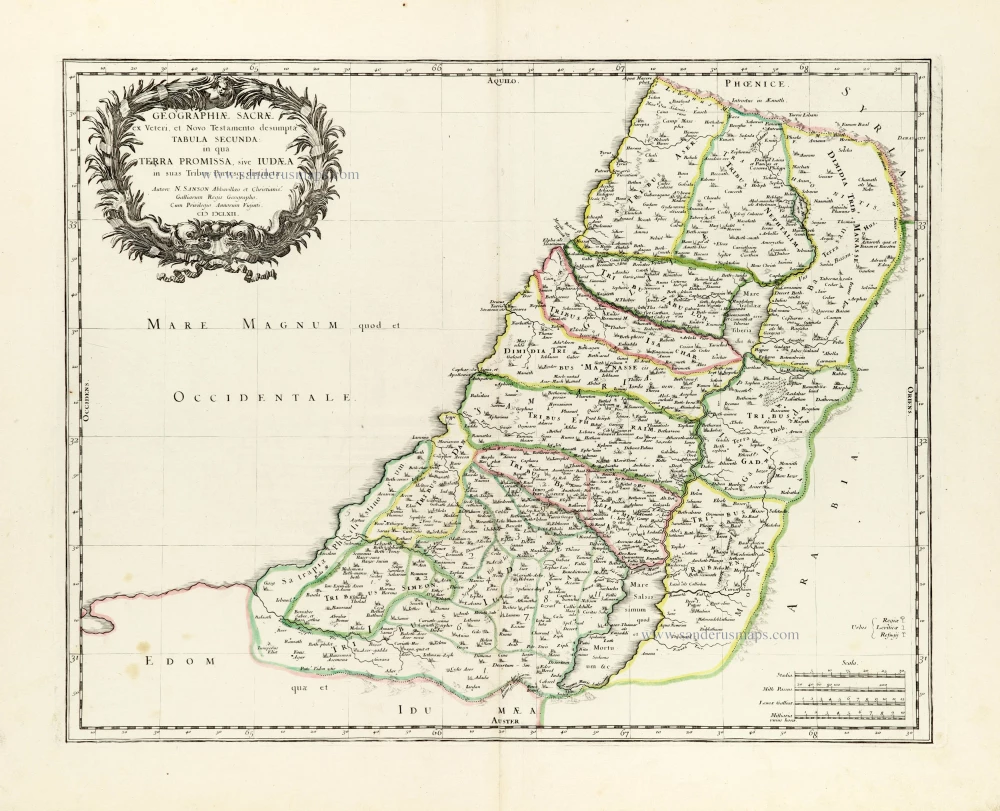
Geographiae Sacrae ex Veteri et Novo Testamento desumptae Tabula Secunda: in qua Terra Promissa, sive Iudaea in suas Tribus Partesq, distincta. 1665
Holy Land by Nicolas Sanson.
[Item number: 30105]
Superb old colouring, heightened with gold.
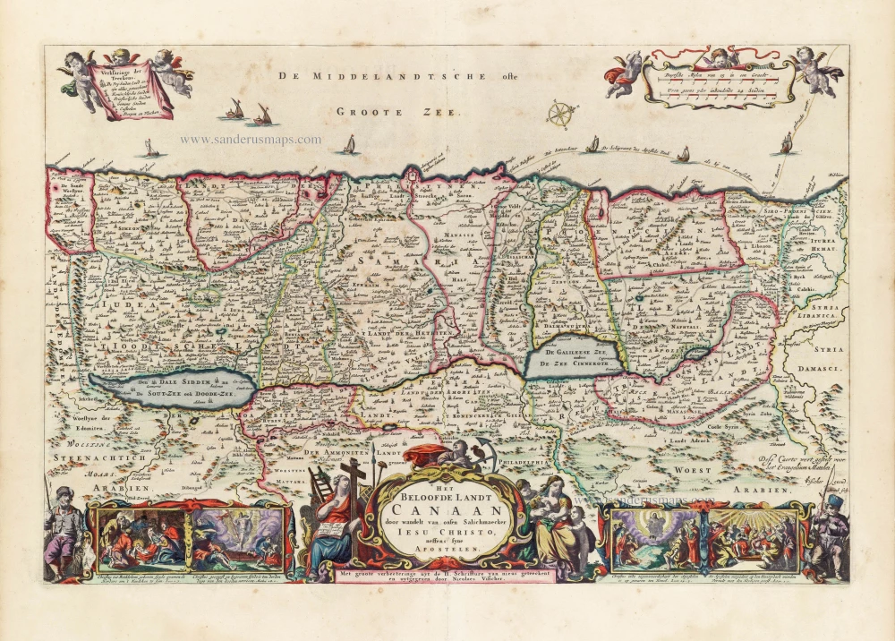
Het Beloofde Landt Canaan door wandelt van onsen Salichmaeker Iesu Christo, neffens syne Apostelen. 1663
Holy Land by Nicolaas Visscher.
[Item number: 30535]
Superb old colouring, heightened with gold.
Perigrinatie ofte Veertigh-Iarige Reyse der Kinderen Israëls. 1663
Holy Land, by Nicolaes Visscher I.
[Item number: 30538]

Holy Land map from the very rare van Liesveldt Bible
Die ghelegentheit ende die palen des lants van Beloften. 1532-1560
Holy Land by van Jacob van Liesveldt.
[Item number: 30549]

Terra Sancta quae in Sacris Terra Promissionis olim Palestina. 1645
Holy Land, by Willem Blaeu.
[Item number: 30914]

Iudaea seu Terra Sancta quae Hebraeorum sive Israelitarum in suas duodecim Tribus divisa; secretis ab invicem Regnis Iuda et Israel. 1692
Holy Land by N. Sanson, so-called published by Hubert Jaillot. (Pirated edition by Pierre Mortier).
[Item number: 31200]

Tabula Terre Sanctae. 1525
Holy Land, by Lorenz Fries.
[Item number: 31846]

Tabula Cananaeae prout tempore Christi et Apostolorum divisa fuit 1618
Holy Land by Petrus Bertius, published by Jodocus Hondius II.
[Item number: 32140]

Terra Sancta sive Promissionis, olim Palestina, in duo divisa Regna, Israel, et Iuda, et in sex subdivisa Provincias ... 1687
Holy Land, by Guillaume Sanson, adapted by Giacomo Cantelli da Vignola, and published by Giovanni de Rossi.
[Item number: 32957]