
Holy Land - Jerusalem by Philippe Briet, published by Pierre Mariette. 1641

The map is divided into two parts: the lower part, a map of Palestine entitled as above, oriented to the east and divided according to the Tribes on both sides of the Jordan. The shoreline runs from "Sidon" to "Rhinocolura". The upper part is divided into three small maps: 1) "Syriae veteris descriptio", showing the Eastern Mediterranean and the Near East; 2) "Hierusalem", a plan of the ancient city; 3) "Exodus Israelis", showing the Wanderings of the Tribes from Ramses in Egypt through the Red Sea and the Sinai Peninsula until they reached Palestine.
According to Laor, this map appeared in Philippe de La Rue's La Terre Saincte en six cartes géographiques, but Pastoureau, who gives the list of the six maps in this atlas, doesn't mention this map. (Pastoureau, Les Atlas Français XVIe-XVIIe siècles. p. 293)
Philippe Briet (1601-1668)
Jesuit priest of Abbeville, historian and cartographer. Author of historical maps; worked for Pierre Mariette and Michael van Lochom, Parisian publishers.
He published his Paralella Geographica in 1648, which contained 144 maps of Europe. He had intended to continue with the other continents but only produced a manuscript of the Asia tome, which was never published. Briet published two other atlases in 1653: the Theatre Geographique de l'Europe, with 79 maps, and the Theatrum Geographicum Europa Veteris, with 57 maps of ancient geography.
Palestinae Delineatio Ad Geographiae Canones Revocata.
Item Number: 30056 Authenticity Guarantee
Category: Antique maps > Asia > Holy Land
Rare antique map of the Holy Land - Jerusalem by Philippe Briet, published by Pierre Mariette.
Title: Palestinae Delineatio Ad Geographiae Canones Revocata.
A Paris, Chez Pierre Mariette en la Rue St. Iacques a l'enseigne de l'Esperance.
Avec Privilege du Roy. 1641.
Henri le Roy fecit.
Cartographer: Christian von Adrichom.
Engraver: Henri Le Roy.
Date of the first edition: 1641.
Date of this map: 1641.
Date on map: 1641.
Copper engraving, printed on paper.
Image size: 395 x 545mm (15.55 x 21.46 inches).
Sheet size: 490 x 640mm (19.29 x 25.2 inches).
Verso: Blank.
Condition: Original coloured in outline, lower centrefold split reinforced.
Condition Rating: A.
Separate publication.
The map is divided into two parts: the lower part, a map of Palestine entitled as above, oriented to the east and divided according to the Tribes on both sides of the Jordan. The shoreline runs from "Sidon" to "Rhinocolura". The upper part is divided into three small maps: 1) "Syriae veteris descriptio", showing the Eastern Mediterranean and the Near East; 2) "Hierusalem", a plan of the ancient city; 3) "Exodus Israelis", showing the Wanderings of the Tribes from Ramses in Egypt through the Red Sea and the Sinai Peninsula until they reached Palestine.
According to Laor, this map appeared in Philippe de La Rue's La Terre Saincte en six cartes géographiques, but Pastoureau, who gives the list of the six maps in this atlas, doesn't mention this map. (Pastoureau, Les Atlas Français XVIe-XVIIe siècles. p. 293)
Philippe Briet (1601-1668)
Jesuit priest of Abbeville, historian and cartographer. Author of historical maps; worked for Pierre Mariette and Michael van Lochom, Parisian publishers.
He published his Paralella Geographica in 1648, which contained 144 maps of Europe. He had intended to continue with the other continents but only produced a manuscript of the Asia tome, which was never published. Briet published two other atlases in 1653: the Theatre Geographique de l'Europe, with 79 maps, and the Theatrum Geographicum Europa Veteris, with 57 maps of ancient geography.
Related items

Palaestinae sive totius Terrae Promissionis nova descriptio Auctore Tilemanno Stella Sigenensi. 1624
Holy Land, by Abraham Ortelius.
[Item number: 1583]

Tribus Aser 1590
The Holy Land, by Adrichomius C.
[Item number: 1891]

Tribus Zabulon, Isachar, Et, Dimidia Manasse ... 1590
Holy Land, by Adrichomius C.
[Item number: 1902]

Vue et Description de Bethleem et de Nazareth et de Plusieurs Singularitez Curieuses .. 1719
Holy Land - Bethlehem - Nazareth, by Z. Châtelain.
[Item number: 16855]

Terra Sancta quae in Sacris Terra Promissionis ol: Palestina 1630
HOLY LAND by Mercator - Janssonius
[Item number: 17710]

Beschreibung des Heiligen Landes Canaan. 1581
The Holy Land, by Bünting H.
[Item number: 18420]
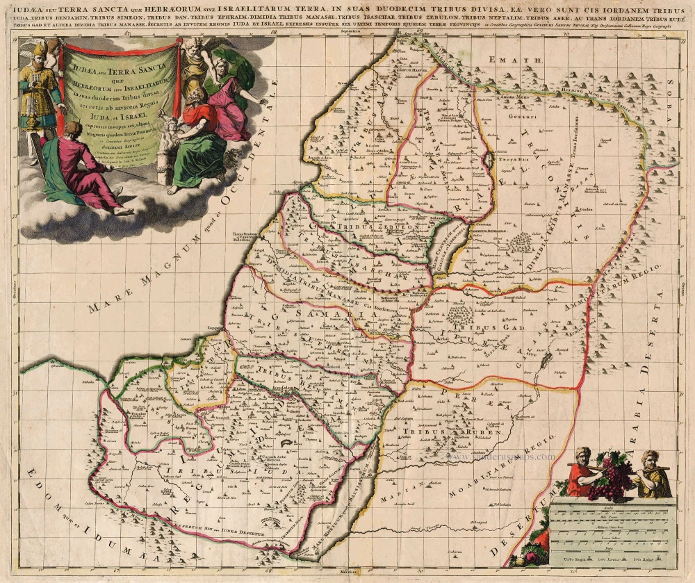
Iudaea, seu Terra Sancta quae Hebraeorum sive Israelitarum ... c. 1700
HOLY LAND by Schenk P.
[Item number: 19146]

Situs Terrae Promissionis. S.S. Bibliorum intelligentiam exacte aperiens per Chr. Adrichom. c. 1658
The Holy Land, by Janssonius J.
[Item number: 19521]
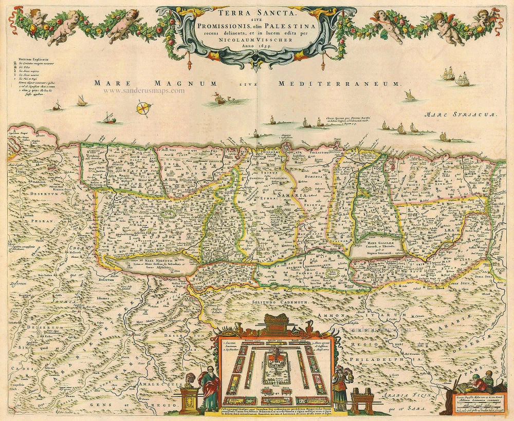
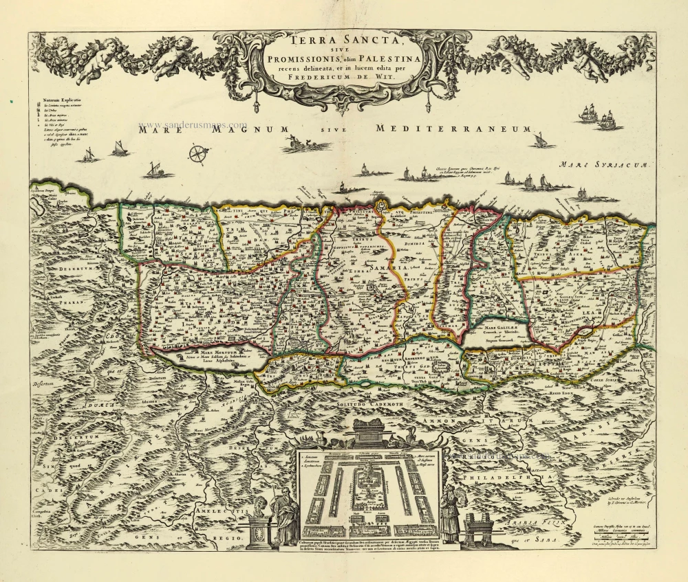
Terra Sancta, sive Promissionis, olim Palestina recens delineata. 1683-1696
The Holy Land, by Visscher N.
[Item number: 19522]

Reisen der Kinder von Israel aus Egypten. 1582
Holy Land - Egypt by Heinrich Bünting.
[Item number: 22612]

Taffel des Heiligen Landes zu dem Newen Testament dienlich. 1582
Holy Land, by Bünting H.
[Item number: 22640]

Terra Sancta, A Petro Laicstain perlustrata, et ab eius ore et schedisà Chistino Schrot in tabulam redacta. 1612
Holy Land by Abraham Ortelius.
[Item number: 23099]

Situs Terrae Canaan sive Terrae Promissionis, hodie Palestinae, ... 1710
The Holy Land, by Jaillot - Covens & Mortier.
[Item number: 23600]

Terra Sancta, sive Promissionis, olim Palestina recens delineata. 1683-1696
The Holy Land by Nicolaas Visscher
[Item number: 24441]
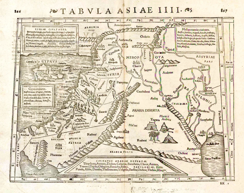
Tabula Asiae IIII. 1571
Middle East - Cyprus - Holy Land by Strabo - Sebastian Münster
[Item number: 25653]

Terre Sainte Suivant les Nouvelles Observations. 1713
The Holy Land, by Pieter van der Aa.
[Item number: 26110]

La Judée ou Terre Sainte divisée en ses Douze Tribus. 1776-79
Holy Land, by Paolo Santini.
[Item number: 27015]
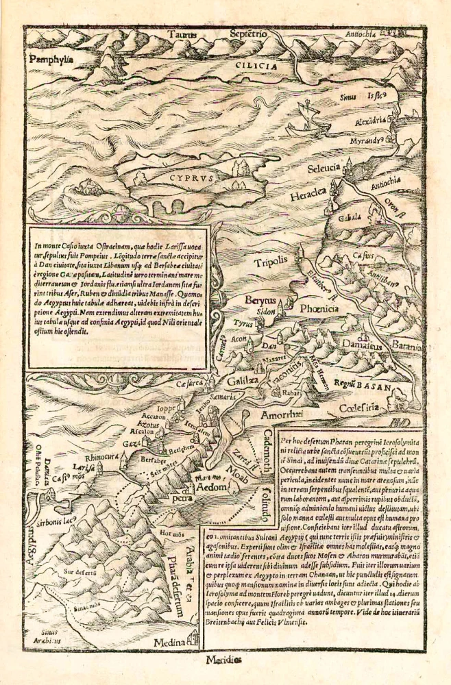
In monte Casio iuxta Ostracinam, ... 1550
Cyprus and the Holy Land, by Sebastian Münster.
[Item number: 27073]
Terra Sancta, sive Promissionis, olim Palestina. after 1721
Holy Land by Frederik de Wit, published by Covens & Mortier.
[Item number: 28329]

Terra Sancta, sive Promissionis, olim Palestina recens delineata. 1664-80
The Holy Land by Nicolaas Visscher.
[Item number: 28582]

Terra Sancta, A Petro Laicstain perlustrata, et ab eius ore et schedisà Chistino Schrot in tabulam redacta. 1601
Holy Land by Abraham Ortelius.
[Item number: 28669]
Parergon map
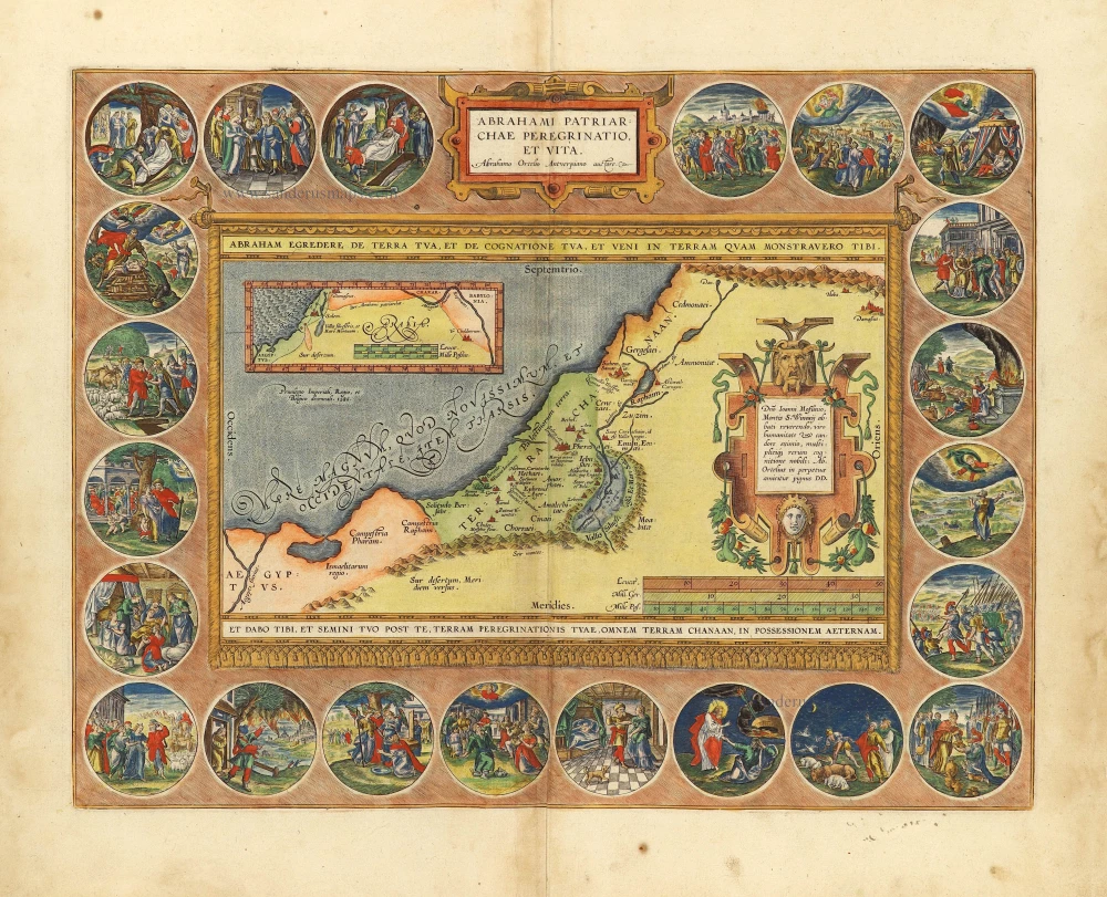
Abrahami Patriarchae Peregrinatio, et Vita. 1612
The Holy Land by Abraham Ortelius.
[Item number: 28921]

Carte de la Terre Sainte Divisée dans Toutes ses Parties selon le nombre des Tribus d'Israel. 1719
Holy Land, by Zacharias Châtelain.
[Item number: 29383]

The most decorative map of the Holy Land to be included in a seventeenth century atlas
Palestina, sive Terrae Sanctae Descriptio. 1666
The Holy Land by Joannes Janssonius.
[Item number: 29972]
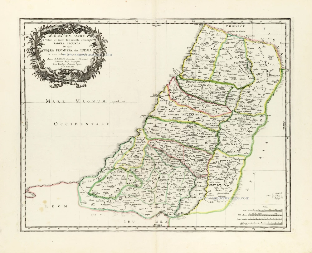
Geographiae Sacrae ex Veteri et Novo Testamento desumptae Tabula Secunda: in qua Terra Promissa, sive Iudaea in suas Tribus Partesq, distincta. 1665
Holy Land by Nicolas Sanson.
[Item number: 30105]

Regnum Salomonicum Seu Tabula digesta ad Libros Judicum, Regum, Paral. et Prophetarum. 1651
Historic map of the Kingdom of Solomon divided into 12 provinces, by Philippe de la Rue, published by Pierre Mariette.
[Item number: 30106]

Pinax Geogpaphicus [sic] Patriarchatus Hierosolymitani [...] 1651
The Patriarchate of Jerusalem, by Philippe de la Rue, published by Pierre Mariette.
[Item number: 30120]
Superb old colouring, heightened with gold.
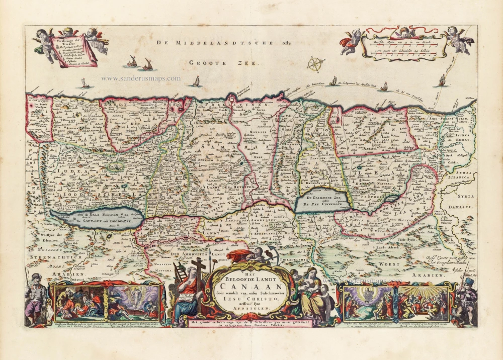
Het Beloofde Landt Canaan door wandelt van onsen Salichmaeker Iesu Christo, neffens syne Apostelen. 1663
Holy Land by Nicolaas Visscher.
[Item number: 30535]
Superb old colouring, heightened with gold.
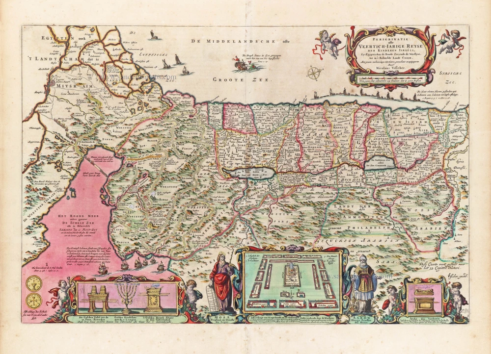
Perigrinatie ofte Veertigh-Iarige Reyse der Kinderen Israëls. 1663
Holy Land, by Nicolaes Visscher I.
[Item number: 30538]

Holy Land map from the very rare van Liesveldt Bible
Die ghelegentheit ende die palen des lants van Beloften. 1532-1560
Holy Land by van Jacob van Liesveldt.
[Item number: 30549]

La saincte cité de Ierusalem iadiz metropolitaine du royaume des Iuifz, & maintenant colonie du Turc. 1568
Jerusalem, by Sebastian Munster.
[Item number: 30601]

Terra Sancta quae in Sacris Terra Promissionis olim Palestina. 1645
Holy Land, by Willem Blaeu.
[Item number: 30914]

Iudaea seu Terra Sancta quae Hebraeorum sive Israelitarum in suas duodecim Tribus divisa; secretis ab invicem Regnis Iuda et Israel. 1692
Holy Land by N. Sanson, so-called published by Hubert Jaillot. (Pirated edition by Pierre Mortier).
[Item number: 31200]
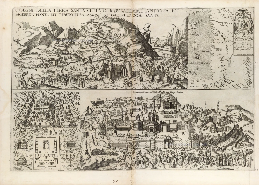
Extremely rare map, only one complete copy recorded
Disegni della Terra Santa Citta di Ierusalemme Anticha et Moderna Pianta di Salomone et D'Altri Luoghi Santi. 1590
Map depicting Jerusalem and the Holy Land, by Nicolas van Aelst.
[Item number: 31414]

Tabula Cananaeae prout tempore Christi et Apostolorum divisa fuit 1618
Holy Land by Petrus Bertius, published by Jodocus Hondius II.
[Item number: 32140]

Iudaea seu Palaestina ob Sacratißima Redemtoris vestigia hodie dicta Terra Sancta prout olim in Duodecim Tribus Divisa separatis ab Invicem Regnis Iuda et Israel expreßis insuper VI ultimi temporis ejusdem Terrae Procinciis. c. 1720
Holy Land, by J.B. Homann.
[Item number: 32192]

First edition!
Ierusalem, et Suburbia eius, sicut Tempore Christi Floruit, cum Locis in quibus Christ Pass. est quae religiose à Christianis observata etiam num Veneratio ni habent descripta per Christianum Adrichom Delphum Delphum. 1588
Jerusalem by Georg Braun and Frans Hogenberg.
[Item number: 32830]

Terra Sancta sive Promissionis, olim Palestina, in duo divisa Regna, Israel, et Iuda, et in sex subdivisa Provincias ... 1687
Holy Land, by Guillaume Sanson, adapted by Giacomo Cantelli da Vignola, and published by Giovanni de Rossi.
[Item number: 32957]