
Scarce
Ceylon (Sri Lanka), by Pieter Van der Aa. 1707
Pieter van der Aa (Leiden, 1659-1733)
Pieter van der Aa was already in 1682 owner of a bookshop and auction house. During his life, he has published an enormous amount of printed material.
After 1700, van der Aa increasingly specialised in books on geography and travel.
He published composite atlases, a series of geographical descriptions of European countries, and some very spectacular works. Between 1706 and 1708 he published the Naauweurige versameling der gedenkwaardigste zee- en land-reysen, in 28 volumes.
Many of Van der Aa’s publications are richly illustrated with maps and plates. He took over many copperplates and prints from other publishers such as Carel Allard and Frederik De Wit. The composite atlases that appeared from his workshop contain a curious mixture of his own material, copies of maps from other publishers, and reprints made from old copper plates, now with his own imprint.
The Galérie agréable du monde, was completed in 1729, and comprised 66 parts, bound in 27 volumes. Van der Aa presented it as a good investment; after publication, the antiquarian value of the work would double, the more so since it was printed in a limited edition of only one hundred copies.
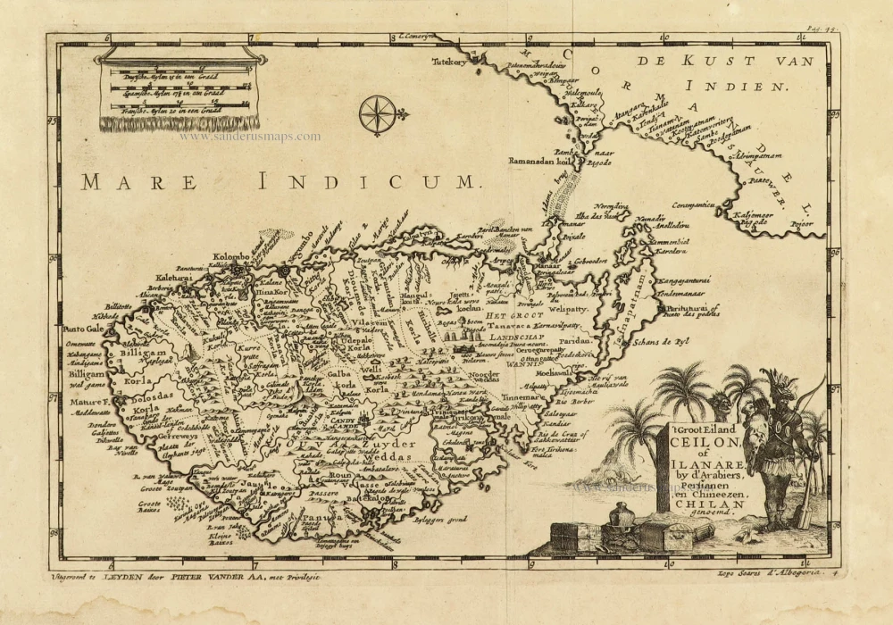
't Groot Eiland Ceilon, of Ilanare. by s'Arabiers, Persianen en Chineezen Chilan genoemd.
Item Number: 32324 Authenticity Guarantee
Category: Antique maps > Asia > India - Ceylon
Ceylon (Sri Lanka), by Pieter Van der Aa.
Title: 't Groot Eiland Ceilon, of Ilanare. by s'Arabiers, Persianen en Chineezen Chilan genoemd.
Uytgevoerd te Leyden door Pieter Vander Aa, met Privilegie. - Lopo Siares d'Albegeria.
Oriented to the west.
Date of the first edition: 1707.
Date of this map: 1707.
Copper engraving, printed on paper.
Image size: 155 x 225mm (6 x 8¾ inches).
Sheet size: 180 x 280mm (7 x 11 inches).
Verso: Blank.
Condition: Excellent.
Condition Rating: A+.
From: Naaukeurige Versameling der gedenk-waardigste Zee- en landreysen na Oost en West-Indien. Leiden, Pieter Van der Aa, 1707.
Pieter van der Aa (Leiden, 1659-1733)
Pieter van der Aa was already in 1682 owner of a bookshop and auction house. During his life, he has published an enormous amount of printed material.
After 1700, van der Aa increasingly specialised in books on geography and travel.
He published composite atlases, a series of geographical descriptions of European countries, and some very spectacular works. Between 1706 and 1708 he published the Naauweurige versameling der gedenkwaardigste zee- en land-reysen, in 28 volumes.
Many of Van der Aa’s publications are richly illustrated with maps and plates. He took over many copperplates and prints from other publishers such as Carel Allard and Frederik De Wit. The composite atlases that appeared from his workshop contain a curious mixture of his own material, copies of maps from other publishers, and reprints made from old copper plates, now with his own imprint.
The Galérie agréable du monde, was completed in 1729, and comprised 66 parts, bound in 27 volumes. Van der Aa presented it as a good investment; after publication, the antiquarian value of the work would double, the more so since it was printed in a limited edition of only one hundred copies.
Related items

Ins. Ceilan quae incolis Tenarisin dicitur. 1638
Sri Lanka (Ceylon), by Jodocus Hondius.
[Item number: 26006]

Carte du Golfe de Bengale, Mer des Indes, et Riviere du Gange, Avec les Païs et Iles d'alentour, Savoir les Côtes de Malabar, Cormandel, Ile de Ceylon, les Maldives, les Rolaumes de Visiapour, Golconda, Guzaratte, etc. 1713
India and Ceylon (Sri Lanka), by Pieter van der Aa.
[Item number: 26095]

Peninsula Indiae citra Gangem, hoc est Orae Celeberrimae Malabar & Coromandel. Cum Adjacente Insula non Minus Celebratissima Ceylon. c. 1737
India & Ceylon, by Homann Heirs.
[Item number: 26752]

Punto de Galle. 1724-26
Galle (Ceylon - Sri Lanka) ,by François Valentyn (Valentijn).
[Item number: 26902]

Narsinga et Ceylon. c. 1600
South India and Ceylon by Barent Langenes & Cornelis Claesz
[Item number: 26999]

Very nice old colour
Iaponia. 1623
Japan, Jodocus Hondius.
[Item number: 27819]
[No title] 1525
Ceylon (Sri Lanka), by Lorenz Fries.
[Item number: 27932]

Baay van Tricoen Male. 1724-26
Sri Lanka (Ceylon) - Trincomalee Bay by François Valentyn (Valentijn).
[Item number: 28627]

Penisola dell'Indo di qua del Gange, e l'Isola di Ceilan nell'Indie Orientali. 1696
India - Ceylon (Sri Lanka) by Vincenzo Coronelli.
[Item number: 28674]

Nouvelle Carte de L'Ile de Ceylon, avec des Remarques Historiques. 1719
Ceylon (Sri Lanka), by Zacharias Châtelain.
[Item number: 29360]

Taprobana. - [Above map :] Descrittione del l'Isola di Taprobana. 1590
Ceylon (Sri Lanka) by Tommaso Porcacchi.
[Item number: 29808]

SCARCE !
Colombo. 1685/90
Ceylon (Sri Lanka) - Colombo, by Carel Allard.
[Item number: 30576]

[Map of the Maldives] [and] Ceylon I. 1618
Maldives and Ceylon, by Petrus Bertius
[Item number: 32170]
Scarce
De Eilanden Maldives of Voormuur van Indien met der selver tußen-gelegen Zeen. 1707
Maldives and Ceylon, by Pieter Van der Aa.
[Item number: 32342]

Nieuwe kaart van het eyland Ceylon. 1724-26
Ceylon (Sri Lanka) by François Valentyn (Valentijn)
[Item number: 32699]