
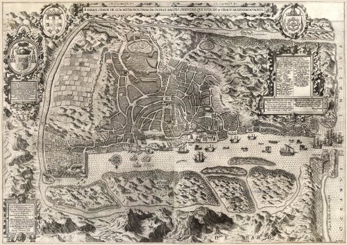
Old antique plan of Goa, by Jan Huygen van Linschoten. 1596


Jan Huygen van Linschoten (1562-c.1611)
Jan Huygen van Linschoten was one of the pathfinders for the first Dutch voyages to the East. Born in Haarlem, his parents moved to Enkhuizen in or after 1572 for political and religious reasons. In 1579 he left for Spain, where his older brothers had already been living for several years. In 1583, Jan Huygen set sail with a fleet heading for Goa in India. There he entered the service of the new archbishop.
The years that Jan Huygen spent in Goa, the administrative centre of Portugal’s widespread colonial territory in the East, provided an excellent opportunity to collect a wealth of information. Ships from all directions came into port here, and he could inform himself on the patterns of trade and the economic opportunities to China and Japan. In the foreword to his Itinerario (1596), Jan Huygen refers to the fact that he could not help but take note of everything. For instance, during his six-year sojourn in Goa, he also drew a bird’s eye view of this city, which he included in the Itinerario. He also gave ample attention to the Portuguese sailing routes to, from, and within Asian waters.
In November 1588 he came back home with the pepper ship Santa Cruz. He interrupted this voyage after an eventful journey and spent two years on the island of Terceira. In 1592 he arrived back in Enkhuizen. With his writings, drawings, and tales, he captured the attention of the town, and people encouraged him to publish the report of his journey.
While preparations for the publication of the Itinerario were in full swing, Jan Huygen took part in the first two polar expeditions as a chief commercial officer on the ships fitted out by Enkhuizen.
After these voyages, Jan Huygen stayed on land. He married with Reynu Meinertsdr Semeyns, daughter of one of Enkhuizen’s regent families. Thanks to his in-laws, he subsequently occupied various positions in the city’s civil administration until he died in 1611.
Jan Huygen van Linschoten and his Itinerario (1595-96).
By the time Jan Huygen returned from India, commercial and scientific circles in the Northern Netherlands were strongly motivated to learn more about overseas territories. He came in contact with the Amsterdam publisher Cornelis Claesz, who had been the publisher of Waghenaer’s cartographic work since 1589. Claesz showed great interest in Van Linschoten’s plans. He realized that on the threshold of a new era, cartographic and maritime works would be in high demand in circles of navigators, merchants, and other interested parties. Van Linschoten’s work could also serve as a guide to unknown territories.
On 14 March 1594, shortly before leaving northbound, Van Linschoten and Claesz signed a contract to print a book on navigation to the East Indies. By the end of this year, the States General granted Jan Huygen a ten-year privilege on the publication of his Itinerario and Reysgeschrift.
The volume published under the title Itinerario would include Van Linschoten’s travel account, supplemented by further information on the peoples, flora, and fauna of the Asian territories. Cornelis Claesz expanded the work and gave some attention to the west coast of Africa and also to America, a territory completely unknown to Van Linschoten. Because Jan Huygen had never been in these areas himself, Bernardus Paludanus was called in to help out. With the aid of Portuguese and Spanish sources, Paludanus and Van Linschoten made a compendium entitled Beschryvinghe van de gantsche Custe van Guinea.
The result of all this was a set of four different and distinctly separate individuals works. Each work has its own title page, its own date of publication, and a dedication. These four parts are usually bound in a single volume, with the Itinerario coming first. Therefore, the contents of the whole work are generally referred to by that name.
The Van Doetecum brothers engraved Jan Huygens drawings. Joannes van Doetecum had already engraved the world map of Petrus Plancius in 1594. Cornelis Claesz included this map in some copies of the 1596-99 editions. Still, in some copies, it was replaced by a map by Joan Baptista Vrients, engraved by the Van Langren brothers. The five detail maps, all of which were engraved by Arnold Floris and Hendrik Floris van Langren, cover a large proportion of the non-European world known at the time.
Jan Huygen van Linschoten’s Itinerarium was one of the most impressive works to be published at the end of the sixteenth century. The report of his northern travels appeared a couple of years later.
Ailhae Cidade de Goa Metropolitana da Indiae Partes Orientais que esta en 15 Graos da Banda da Norte.
Item Number: 26851 Authenticity Guarantee
Category: Antique maps > Asia > India - Ceylon
Old, antique bird's eye view and plan of the isle and city of Goa, by Jan Huygen van Linschoten.
With dedication by Van Linschoten to archduke Albert of Austria.
Engraver: Baptista Van Doetecum.
Date of the first edition: 1596
Date of this map: 1596
Date on map: 1595
Copper engraving, printed on two sheets of paper, joined.
Size (not including margins): 56.5 x 79.5cm (22 x 31 inches)
Verso: Blank
Condition: Narrow margins as issued, excellent.
Condition Rating: A
References: Schilder 7, Ill. 10.2; TNH Doet4, #932 II.
From: Jan Huygen van Linschoten, Itinerario, Voyage ofte Schipvaert naer Oost ofte Portugaels Indien.... Amsterdam: C. Claesz, 1595-96.
<
"One of the pathfinders for the first Dutch voyages to the East was surely Jan Huygen van Linschoten (1562-1611), whose Reysgeschrift (1595) and Itinerario (1596) were published by Cornelis Claesz. The young Jan Huygen left for Spain at age 16. At first, he was enticed by distant lands. In 1579, he followed his older brothers, who had already been living in Spain for several years. In 1583, he set sail with a fleet heading for Goa in India. There, he entered the service of the new archbishop.
The years that Jan Huygen spent in Goa, the administrative center of Portugal's widespread colonial territory in the East, provided an excellent opportunity to collect a wealth of information. Ships from all directions came into port here, and a keen observer like Jan Huygen could inform himself on the patterns of trade and the economic opportunities all the way to China and Japan. Gathering information about the trade, he also wanted to find out everything about the peoples, plants, and animals in diverse Asian territories. In the foreword to his Itinerario, Jan Huygen refers to the fact that he could not help but take note of everything (translation): to take notes, lay down in drawings or draw in image everything to the best of my ability. For instance, during his six-year sojourn in Goa, he also drew a bird's eye view of this city. Later; Baptista van Doetecum made a copper engraving of the town plan; it was included in the Itinerario and also appeared separately."
Jan Huygen van Linschoten (1562-c.1611)
Jan Huygen van Linschoten was one of the pathfinders for the first Dutch voyages to the East. Born in Haarlem, his parents moved to Enkhuizen in or after 1572 for political and religious reasons. In 1579 he left for Spain, where his older brothers had already been living for several years. In 1583, Jan Huygen set sail with a fleet heading for Goa in India. There he entered the service of the new archbishop.
The years that Jan Huygen spent in Goa, the administrative centre of Portugal’s widespread colonial territory in the East, provided an excellent opportunity to collect a wealth of information. Ships from all directions came into port here, and he could inform himself on the patterns of trade and the economic opportunities to China and Japan. In the foreword to his Itinerario (1596), Jan Huygen refers to the fact that he could not help but take note of everything. For instance, during his six-year sojourn in Goa, he also drew a bird’s eye view of this city, which he included in the Itinerario. He also gave ample attention to the Portuguese sailing routes to, from, and within Asian waters.
In November 1588 he came back home with the pepper ship Santa Cruz. He interrupted this voyage after an eventful journey and spent two years on the island of Terceira. In 1592 he arrived back in Enkhuizen. With his writings, drawings, and tales, he captured the attention of the town, and people encouraged him to publish the report of his journey.
While preparations for the publication of the Itinerario were in full swing, Jan Huygen took part in the first two polar expeditions as a chief commercial officer on the ships fitted out by Enkhuizen.
After these voyages, Jan Huygen stayed on land. He married with Reynu Meinertsdr Semeyns, daughter of one of Enkhuizen’s regent families. Thanks to his in-laws, he subsequently occupied various positions in the city’s civil administration until he died in 1611.
Jan Huygen van Linschoten and his Itinerario (1595-96).
By the time Jan Huygen returned from India, commercial and scientific circles in the Northern Netherlands were strongly motivated to learn more about overseas territories. He came in contact with the Amsterdam publisher Cornelis Claesz, who had been the publisher of Waghenaer’s cartographic work since 1589. Claesz showed great interest in Van Linschoten’s plans. He realized that on the threshold of a new era, cartographic and maritime works would be in high demand in circles of navigators, merchants, and other interested parties. Van Linschoten’s work could also serve as a guide to unknown territories.
On 14 March 1594, shortly before leaving northbound, Van Linschoten and Claesz signed a contract to print a book on navigation to the East Indies. By the end of this year, the States General granted Jan Huygen a ten-year privilege on the publication of his Itinerario and Reysgeschrift.
The volume published under the title Itinerario would include Van Linschoten’s travel account, supplemented by further information on the peoples, flora, and fauna of the Asian territories. Cornelis Claesz expanded the work and gave some attention to the west coast of Africa and also to America, a territory completely unknown to Van Linschoten. Because Jan Huygen had never been in these areas himself, Bernardus Paludanus was called in to help out. With the aid of Portuguese and Spanish sources, Paludanus and Van Linschoten made a compendium entitled Beschryvinghe van de gantsche Custe van Guinea.
The result of all this was a set of four different and distinctly separate individuals works. Each work has its own title page, its own date of publication, and a dedication. These four parts are usually bound in a single volume, with the Itinerario coming first. Therefore, the contents of the whole work are generally referred to by that name.
The Van Doetecum brothers engraved Jan Huygens drawings. Joannes van Doetecum had already engraved the world map of Petrus Plancius in 1594. Cornelis Claesz included this map in some copies of the 1596-99 editions. Still, in some copies, it was replaced by a map by Joan Baptista Vrients, engraved by the Van Langren brothers. The five detail maps, all of which were engraved by Arnold Floris and Hendrik Floris van Langren, cover a large proportion of the non-European world known at the time.
Jan Huygen van Linschoten’s Itinerarium was one of the most impressive works to be published at the end of the sixteenth century. The report of his northern travels appeared a couple of years later.
Related items

Anfa, quibusdam Anaffa [on sheet with] Azaamurum [and] Diu [and] Goa 1599
Casablanca (Anfa) - Azemmour (Azamor) - Diu - Old Goa (Velha Goa), by Georg Braun and Frans Hogenberg.
[Item number: 23246]

Carte des Cotes de Malabar et de Coromandel. 1721-41
India by Guillaume Delisle, published by Covens & Mortier.
[Item number: 23609]

Anfa, quibusdam Anaffa [on sheet with] Azaamurum [and] Diu [and] Goa. 1582
Casablanca (Anfa) - Azemmour (Azamor) - Diu - Old Goa (Velha Goa), by Braun & Hogenberg.
[Item number: 25333]

Magni Mogolis Imperium. After 1721
Mongol Empire, by Frederick de Wit - Covens & Mortier.
[Item number: 25838]

Goa. 1638
Goa, by M. Merian.
[Item number: 25903]

Carte du Golfe de Bengale, Mer des Indes, et Riviere du Gange, Avec les Païs et Iles d'alentour, Savoir les Côtes de Malabar, Cormandel, Ile de Ceylon, les Maldives, les Rolaumes de Visiapour, Golconda, Guzaratte, etc. 1713
India and Ceylon (Sri Lanka), by Pieter van der Aa.
[Item number: 26095]

L'Inde de ça le Gange. 1713
India, by Pieter van der Aa.
[Item number: 26107]

Nieuwe kaart van Choromandel ende Malabar. 1724-26
Southern India, by François Valentyn (Valentijn).
[Item number: 26896]