
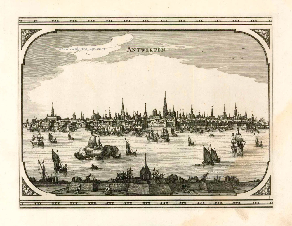
Antwerp, by Georg Braun and Frans Hogenberg, after G. Hoefnagel. 1596
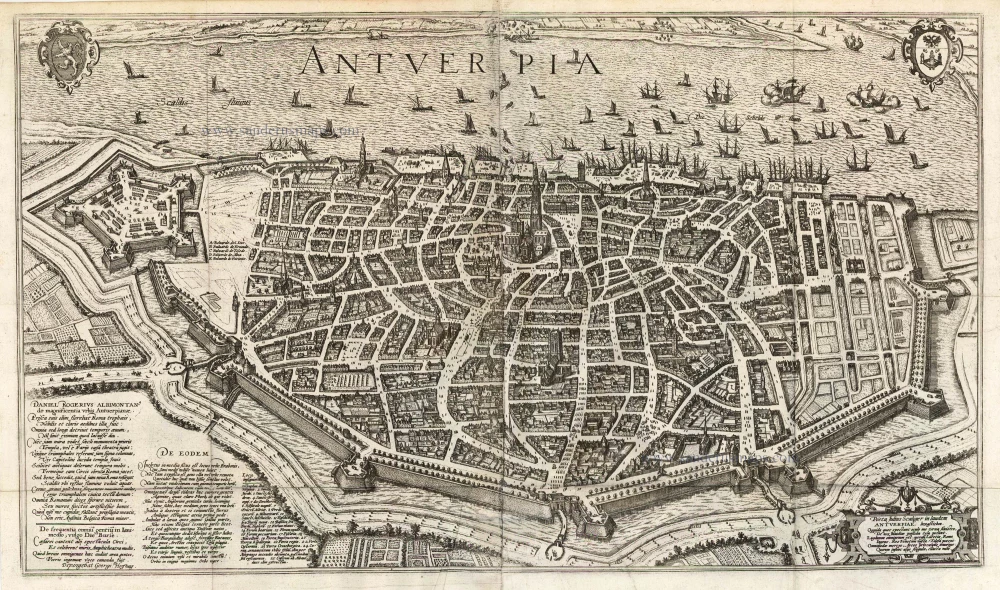
COMMENTARY BY BRAUN: "The city is in rich possession of that which belongs to the nourishment of the soul and the practice of the Christian religion. For it has 5 parish churches, 9 monasteries and nunneries, 8 chapels, 3 hospices, 24 houses of God. The Franciscan monastery is particularly famous and invested with a magnificent library, which was plundered in the wars gone by, however. [...] In the very centre of the city is a large square called the Bourse, which is lined with magnificent columns supporting the covered colonnade and which is very skilfully vaulted: it looks as if it were panelled in wood. In the colonade there are all sorts of things for sale that are interesting to look at; the merchants meet here every day at certain times to trade their wares."
The two plan views (the first appeared in the 1st volume) show the Belgian port on the River Schelde from a bird's-eye perspective. The eye is struck by the star-shaped citadel built by the Duke of Alba on Antwerp's southern side, the defensive moat and the harbour serving the prosperous centre of commerce. The city centre is clearly recognizable with the Onze-Lieve-Vrouwe cathedral (1), its town hall (24) behind it overlooking the Grote Markt and the fish market (17). The north tower of the Gothic cathedral is the city landmark. First mentioned in records in AD 726, Antwerp was granted its charter in 1291 and in 1315 became a Hansa town. The merchants' guilds relocated here and between 1347 and 1496 Antwerp's population grew from 5,000 to 50,000; by 1565 this figure is estimated to have reached 95,000. In the 16th century Antwerp was also an important centre of the arts and home to the leading printer and publisher north of the Alps, Christoffel Plantin. The prosperous metropolis attracted numerous artists (including Jan Brueghel the Elder, Peter Paul Rubens and Anthony van Dyck). But Antwerp, too, became embroiled in the Wars of Religion, and in 1585, the city was taken by the Alexander Farnese, Duke of Parma. Countless Protestant merchants and craftsmen were subsequently driven out of the city, whose importance declined sharply as a result. (Taschen)
Braun G. & Hogenberg F. and the Civitates Orbis Terrarum.
The Civitates Orbis Terrarum, also known as the 'Braun & Hogenberg', is a six-volume town atlas and the most excellent book of town views and plans ever published: 363 engravings, sometimes beautifully coloured. It was one of the best-selling works in the last quarter of the 16th century. Georg Braun, a skilled writer, wrote the text accompanying the plans and views on the verso. Many plates were engraved after the original drawings of a professional artist, Joris Hoefnagel (1542-1600). The first volume was published in Latin in 1572 and the sixth in 1617. Frans Hogenberg, a talented engraver, created the tables for volumes I through IV, and Simon van den Neuwel made those for volumes V and VI. Other contributors were cartographers Daniel Freese and Heinrich Rantzau, who provided valuable geographical information. Works by Jacob van Deventer, Sebastian Münster, and Johannes Stumpf were also used as references. Translations appeared in German and French, making the atlas accessible to a broader audience.
Since its original publication of volume 1 in 1572, the Civitates Orbis Terrarum has left an indelible mark on the history of cartography. Seven more editions followed the first volume in 1575, 1577, 1582, 1588, 1593, 1599, and 1612. Vol.2, initially released in 1575, saw subsequent editions in 1597 and 1612. The subsequent volumes, each a treasure trove of historical insights, graced the world in 1581, 1588, 1593, 1599, and 1606. The German translation of the first volume, a testament to its widespread appeal, debuted in 1574, followed by the French edition in 1575.
Several printers were involved: Theodor Graminaeus, Heinrich von Aich, Gottfried von Kempen, Johannis Sinniger, Bertram Buchholtz, and Peter von Brachel, all of whom worked in Cologne.
Georg Braun (1541-1622)
Georg Braun, the author of the text accompanying the plans and views in the Civitates Orbis Terrarum, was born in Cologne in 1541. After his studies in Cologne, he entered the Jesuit Order as a novice, indicating his commitment to learning and intellectual pursuits. In 1561, he obtained his bachelor's degree; in 1562, he received his Magister Artium, further demonstrating his academic achievements. Although he left the Jesuit Order, he continued his studies in theology, gaining a licentiate in theology. His theological background likely influenced the content and tone of the text in the Civitates Orbis Terrarum, adding a unique perspective to the work.
Frans Hogenberg (1535-1590)
Frans Hogenberg was a Flemish and German painter, engraver, and mapmaker. He was born in Mechelen as the son of Nicolaas Hogenberg.
By the end of the 1560s, Frans Hogenberg was employed upon Abraham Ortelius's Theatrum Orbis Terrarum, published in 1570; he is named an engraver of numerous maps. In 1568, he was banned from Antwerp by the Duke of Alva and travelled to London, where he stayed a few years before emigrating to Cologne. He immediately embarked on his two most important works, the Civitates, published in 1572 and the Geschichtsblätter, which appeared in several series from 1569 until about 1587.
Thanks to large-scale projects like the Geschichtsblätter and the Civitates, Hogenberg's social circumstances improved with each passing year. He died as a wealthy man in Cologne in 1590.
Antverpia
Currently not available
Item Number: 5602 Authenticity Guarantee
Category: Antique maps > Europe > Belgium - Cities
Old, antique map - Bird's-eye view plan of Antwerp by Braun and Hogenberg, after G. Hoefnagel,
With key to locations.
Title: Antverpia
Date of the first edition: 1596.
Date of this map: 1596.
Copper engraving, printed on paper.
Size (not including margins): 455 x 785mm (17.91 x 30.91 inches).
Verso: Latin text.
Condition: Uncoloured, a few old reinforcements.
Condition Rating: .
From: Urbium Praecipuarum Mundi Theatrum Quintum Auctore Georgio Braunio Agrippinate. Part 5. Köln, 1596/97. (Van der Krogt 4, 41:1.5)
COMMENTARY BY BRAUN: "The city is in rich possession of that which belongs to the nourishment of the soul and the practice of the Christian religion. For it has 5 parish churches, 9 monasteries and nunneries, 8 chapels, 3 hospices, 24 houses of God. The Franciscan monastery is particularly famous and invested with a magnificent library, which was plundered in the wars gone by, however. [...] In the very centre of the city is a large square called the Bourse, which is lined with magnificent columns supporting the covered colonnade and which is very skilfully vaulted: it looks as if it were panelled in wood. In the colonade there are all sorts of things for sale that are interesting to look at; the merchants meet here every day at certain times to trade their wares."
The two plan views (the first appeared in the 1st volume) show the Belgian port on the River Schelde from a bird's-eye perspective. The eye is struck by the star-shaped citadel built by the Duke of Alba on Antwerp's southern side, the defensive moat and the harbour serving the prosperous centre of commerce. The city centre is clearly recognizable with the Onze-Lieve-Vrouwe cathedral (1), its town hall (24) behind it overlooking the Grote Markt and the fish market (17). The north tower of the Gothic cathedral is the city landmark. First mentioned in records in AD 726, Antwerp was granted its charter in 1291 and in 1315 became a Hansa town. The merchants' guilds relocated here and between 1347 and 1496 Antwerp's population grew from 5,000 to 50,000; by 1565 this figure is estimated to have reached 95,000. In the 16th century Antwerp was also an important centre of the arts and home to the leading printer and publisher north of the Alps, Christoffel Plantin. The prosperous metropolis attracted numerous artists (including Jan Brueghel the Elder, Peter Paul Rubens and Anthony van Dyck). But Antwerp, too, became embroiled in the Wars of Religion, and in 1585, the city was taken by the Alexander Farnese, Duke of Parma. Countless Protestant merchants and craftsmen were subsequently driven out of the city, whose importance declined sharply as a result. (Taschen)
Braun G. & Hogenberg F. and the Civitates Orbis Terrarum.
The Civitates Orbis Terrarum, also known as the 'Braun & Hogenberg', is a six-volume town atlas and the most excellent book of town views and plans ever published: 363 engravings, sometimes beautifully coloured. It was one of the best-selling works in the last quarter of the 16th century. Georg Braun, a skilled writer, wrote the text accompanying the plans and views on the verso. Many plates were engraved after the original drawings of a professional artist, Joris Hoefnagel (1542-1600). The first volume was published in Latin in 1572 and the sixth in 1617. Frans Hogenberg, a talented engraver, created the tables for volumes I through IV, and Simon van den Neuwel made those for volumes V and VI. Other contributors were cartographers Daniel Freese and Heinrich Rantzau, who provided valuable geographical information. Works by Jacob van Deventer, Sebastian Münster, and Johannes Stumpf were also used as references. Translations appeared in German and French, making the atlas accessible to a broader audience.
Since its original publication of volume 1 in 1572, the Civitates Orbis Terrarum has left an indelible mark on the history of cartography. Seven more editions followed the first volume in 1575, 1577, 1582, 1588, 1593, 1599, and 1612. Vol.2, initially released in 1575, saw subsequent editions in 1597 and 1612. The subsequent volumes, each a treasure trove of historical insights, graced the world in 1581, 1588, 1593, 1599, and 1606. The German translation of the first volume, a testament to its widespread appeal, debuted in 1574, followed by the French edition in 1575.
Several printers were involved: Theodor Graminaeus, Heinrich von Aich, Gottfried von Kempen, Johannis Sinniger, Bertram Buchholtz, and Peter von Brachel, all of whom worked in Cologne.
Georg Braun (1541-1622)
Georg Braun, the author of the text accompanying the plans and views in the Civitates Orbis Terrarum, was born in Cologne in 1541. After his studies in Cologne, he entered the Jesuit Order as a novice, indicating his commitment to learning and intellectual pursuits. In 1561, he obtained his bachelor's degree; in 1562, he received his Magister Artium, further demonstrating his academic achievements. Although he left the Jesuit Order, he continued his studies in theology, gaining a licentiate in theology. His theological background likely influenced the content and tone of the text in the Civitates Orbis Terrarum, adding a unique perspective to the work.
Frans Hogenberg (1535-1590)
Frans Hogenberg was a Flemish and German painter, engraver, and mapmaker. He was born in Mechelen as the son of Nicolaas Hogenberg.
By the end of the 1560s, Frans Hogenberg was employed upon Abraham Ortelius's Theatrum Orbis Terrarum, published in 1570; he is named an engraver of numerous maps. In 1568, he was banned from Antwerp by the Duke of Alva and travelled to London, where he stayed a few years before emigrating to Cologne. He immediately embarked on his two most important works, the Civitates, published in 1572 and the Geschichtsblätter, which appeared in several series from 1569 until about 1587.
Thanks to large-scale projects like the Geschichtsblätter and the Civitates, Hogenberg's social circumstances improved with each passing year. He died as a wealthy man in Cologne in 1590.
Related items
Rare
Antwerpen. 1726
Antwerpen by D. Fassmann
[Item number: 5946]
Rare.
Andorff c. 1650
Antwerp (Antwerpen), by Lucas Schnitzer.
[Item number: 7025]
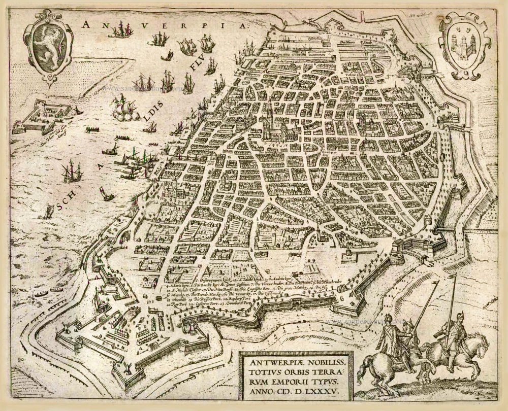
Antwerpiae Nobiliss. totius Orbis Terrarum Emporii Typus. Anno.M.D.LXXXV. (1585). c. 1586
Antwerp (Antwerpen), by Frans Hogenberg.
[Item number: 8017]
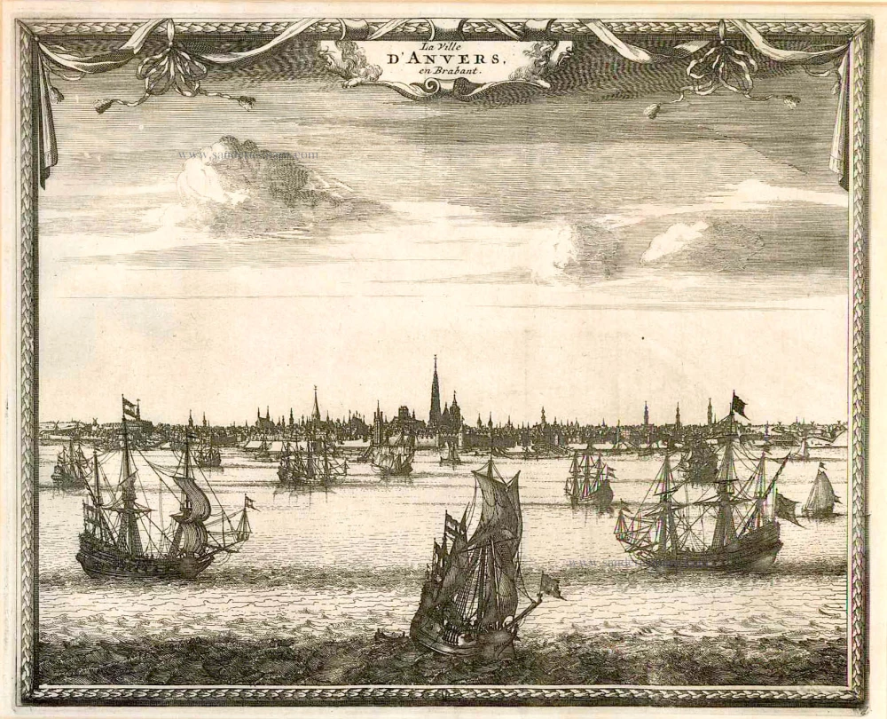
La Ville d'Anvers, en Brabant. c.1715
Antwerpen by Pieter van der Aa
[Item number: 11769]
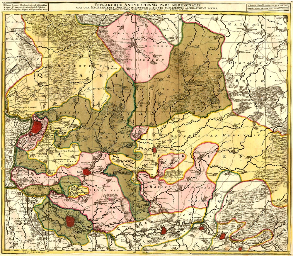
Tetrarchiae Antverpiensis Pars Meridionalis 1683-1696
Antwerpen - Mechelen by Visscher N. II.
[Item number: 14777]

Tertia Pars Brabantiae qua continetur Marchionat S.R.I. horum urbs primaria Antverpia. 1641-42
The Marquisate of Antwerp, by Willem Blaeu.
[Item number: 17537]
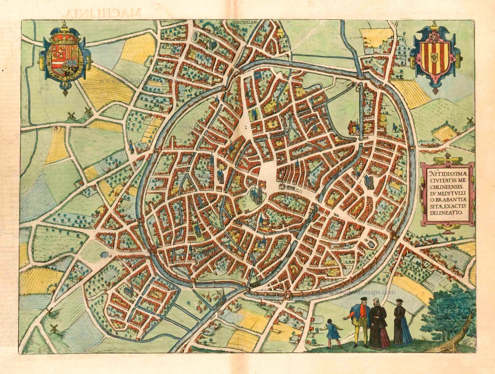
Mechelen - Nitidissimae Civitatis Mechlineensis in meditullio Brabantiae sitae, exactis: delineatio 1581-88
Mechelen, by Braun & Hogenberg.
[Item number: 18002]
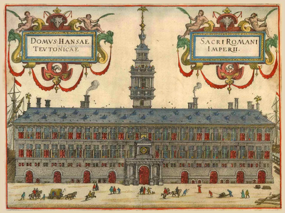
Domus Hansae Teutonicae - Sacri Romani Imperi. 1612
Hanse (Antwerp), by Lodovico Guicciardini.
[Item number: 18160]
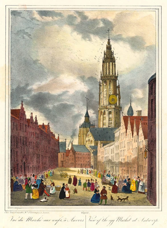
Vue du Marché aux oeufs, à Anvers - View of the egg Market at Antwerp. c. 1846
Antwerpen Eiermarkt by Granello L.
[Item number: 21811]
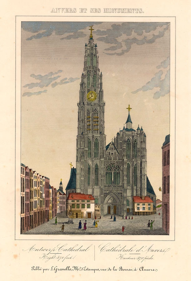
Antwerp Cathedral - Cathédrale d'Anvers c. 1846
Antwerp Cathedral (Antwerpen Kathedraal), by Granello L.
[Item number: 21821]
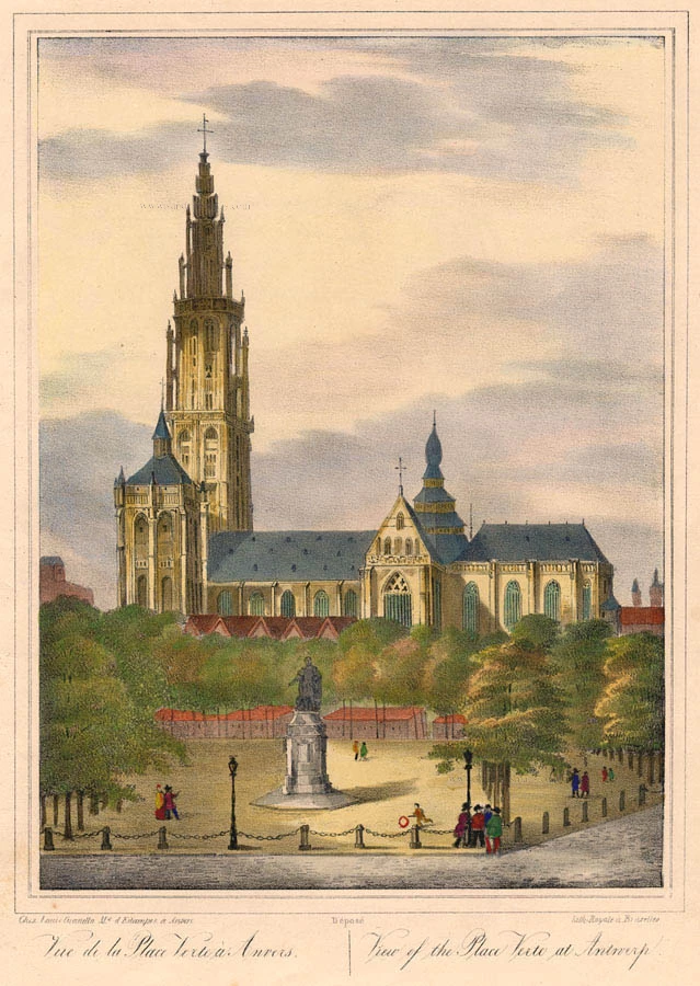
Vue de la Place Verte à Anvers. - View of the Place Verte at Antwerp. c. 1846
Antwerpen Groenplaats by Granello L.
[Item number: 21826]
Marchionatus Sacri Imperiit Dominii Mechelini Tabula 1721-41
Mechelen - Antwerpen, by Covens & Mortier.
[Item number: 23690]
Antwerpen. 1656
Antwerpen by Visscher N. - Schut P.H.
[Item number: 25371]

Beautiful original colour
Arx Antverpensis. 1652
Antwerpen - Citadel, by Joan Blaeu.
[Item number: 28896]
Rare
[No title] c. 1850
Antwerp Cathedral, large lithograph.
[Item number: 30799]