
Lublin (Poland), by Georg Braun and Frans Hogenberg. 1617
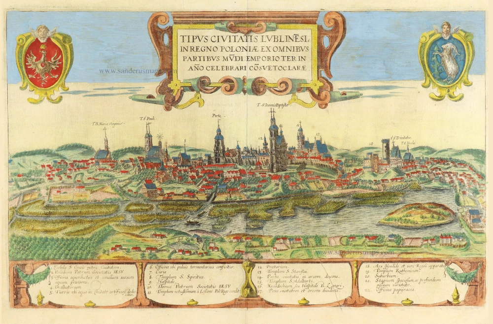

TRANSLATION OF CARTOUCHE TEXT: Impression of the illustrious city of Lublin in the Kingdom of Poland; a market for all the world is customarily held here three times a year.
COMMENTARY BY BRAUN (on verso): "After the royal capital of Cracow, Lublin is almost the most distinguished city in Poland. It has strong walls and deep moats and is thus capable of withstanding not only a surprise attack but also a siege. In this city, three big fairs are held, each lasting a month. It is astonishing how many nations are represented in them, for instance, Germans, Greeks, Armenians, Arabs, Russians, Tatars and even French, Italians and English. There are also many Jews living in the suburbs, and this is where Poland's most important synagogue or school is located."
This is a view of Lubin looking towards the northwest over the marshy flats of the River Bystrzyca. Many church spires can be seen in the city, which received its municipal charter in 1317. It is surrounded by a Jewish suburb founded in the 12th century next to a castle (18). The city is dominated by the Jesuit church of St John and by the Cracow gate. From the 16th century onwards, Lublin was one of the most important Jewish cities in Europe and a centre of Jewish scholarship, with a Talmud academy that was granted the rights of a university in 1567 and was nicknamed the "Jewish Oxford". At the beginning of the 20th century, Jews constituted about half of the population of Lublin. (Taschen)
Braun G. & Hogenberg F. and the Civitates Orbis Terrarum.
The Civitates Orbis Terrarum, also known as the 'Braun & Hogenberg', is a six-volume town atlas and the most excellent book of town views and plans ever published: 363 engravings, sometimes beautifully coloured. It was one of the best-selling works in the last quarter of the 16th century. Georg Braun, a skilled writer, wrote the text accompanying the plans and views on the verso. Many plates were engraved after the original drawings of a professional artist, Joris Hoefnagel (1542-1600). The first volume was published in Latin in 1572 and the sixth in 1617. Frans Hogenberg, a talented engraver, created the tables for volumes I through IV, and Simon van den Neuwel made those for volumes V and VI. Other contributors were cartographers Daniel Freese and Heinrich Rantzau, who provided valuable geographical information. Works by Jacob van Deventer, Sebastian Münster, and Johannes Stumpf were also used as references. Translations appeared in German and French, making the atlas accessible to a wider audience.
Since its original publication of volume 1 in 1572, the Civitates Orbis Terrarum has left an indelible mark on the history of cartography. The first volume was followed by seven more editions in 1575, 1577, 1582, 1588, 1593, 1599, and 1612. Vol.2, initially released in 1575, saw subsequent editions in 1597 and 1612. The subsequent volumes, each a treasure trove of historical insights, graced the world in 1581, 1588, 1593, 1599, and 1606. The German translation of the first volume, a testament to its widespread appeal, debuted in 1574, followed by the French edition in 1575.
Several printers were involved: Theodor Graminaeus, Heinrich von Aich, Gottfried von Kempen, Johannis Sinniger, Bertram Buchholtz, and Peter von Brachel, all of whom worked in Cologne.
Georg Braun (1541-1622)
Georg Braun, the author of the text accompanying the plans and views in the Civitates Orbis Terrarum, was born in Cologne in 1541. After his studies in Cologne, he entered the Jesuit Order as a novice, indicating his commitment to learning and intellectual pursuits. In 1561, he obtained his bachelor's degree; in 1562, he received his Magister Artium, further demonstrating his academic achievements. Although he left the Jesuit Order, he continued his studies in theology, gaining a licentiate in theology. His theological background likely influenced the content and tone of the text in the Civitates Orbis Terrarum, adding a unique perspective to the work.
Frans Hogenberg (1535-1590)
Frans Hogenberg was a Flemish and German painter, engraver, and mapmaker. He was born in Mechelen as the son of Nicolaas Hogenberg.
By the end of the 1560s, Frans Hogenberg was employed upon Abraham Ortelius's Theatrum Orbis Terrarum, published in 1570; he is named an engraver of numerous maps. In 1568, he was banned from Antwerp by the Duke of Alva and travelled to London, where he stayed a few years before emigrating to Cologne. He immediately embarked on his two most important works, the Civitates, published in 1572 and the Geschichtsblätter, which appeared in several series from 1569 until about 1587.
Thanks to large-scale projects like the Geschichtsblätter and the Civitates, Hogenberg's social circumstances improved with each passing year. He died as a wealthy man in Cologne in 1590.
Tipus Civitatis Lublinesi in Regno Poloniae ex omnibus partibus mùdi Emporioa Ter in Año Celebrari Cõsvetoclarae.
Item Number: 29281 Authenticity Guarantee
Category: Antique maps > Europe > Eastern Europe
Old, antique panoramic view of Lublin, by Georg Braun and Frans Hogenberg.
Title: Tipus Civitatis Lublinesi in Regno Poloniae ex omnibus partibus mùdi Emporioa Ter in Año Celebrari Cõsvetoclarae.
Date of the first edition: 1617.
Date of this map: 1617.
Copper engraving, printed on paper.
Map size: 310 x 495mm (12.2 x 19.49 inches).
Sheet size: 385 x 510mm (15.16 x 20.08 inches).
Verso: Latin text.
Condition: Original coloured, excellent.
Condition Rating: A+.
From: Theatri praecipuarum Totius Mundi Urbium Liber Sextus Anno MDCXVII. (Van der Krogt 4, 41:1.6)
TRANSLATION OF CARTOUCHE TEXT: Impression of the illustrious city of Lublin in the Kingdom of Poland; a market for all the world is customarily held here three times a year.
COMMENTARY BY BRAUN (on verso): "After the royal capital of Cracow, Lublin is almost the most distinguished city in Poland. It has strong walls and deep moats and is thus capable of withstanding not only a surprise attack but also a siege. In this city, three big fairs are held, each lasting a month. It is astonishing how many nations are represented in them, for instance, Germans, Greeks, Armenians, Arabs, Russians, Tatars and even French, Italians and English. There are also many Jews living in the suburbs, and this is where Poland's most important synagogue or school is located."
This is a view of Lubin looking towards the northwest over the marshy flats of the River Bystrzyca. Many church spires can be seen in the city, which received its municipal charter in 1317. It is surrounded by a Jewish suburb founded in the 12th century next to a castle (18). The city is dominated by the Jesuit church of St John and by the Cracow gate. From the 16th century onwards, Lublin was one of the most important Jewish cities in Europe and a centre of Jewish scholarship, with a Talmud academy that was granted the rights of a university in 1567 and was nicknamed the "Jewish Oxford". At the beginning of the 20th century, Jews constituted about half of the population of Lublin. (Taschen)
Braun G. & Hogenberg F. and the Civitates Orbis Terrarum.
The Civitates Orbis Terrarum, also known as the 'Braun & Hogenberg', is a six-volume town atlas and the most excellent book of town views and plans ever published: 363 engravings, sometimes beautifully coloured. It was one of the best-selling works in the last quarter of the 16th century. Georg Braun, a skilled writer, wrote the text accompanying the plans and views on the verso. Many plates were engraved after the original drawings of a professional artist, Joris Hoefnagel (1542-1600). The first volume was published in Latin in 1572 and the sixth in 1617. Frans Hogenberg, a talented engraver, created the tables for volumes I through IV, and Simon van den Neuwel made those for volumes V and VI. Other contributors were cartographers Daniel Freese and Heinrich Rantzau, who provided valuable geographical information. Works by Jacob van Deventer, Sebastian Münster, and Johannes Stumpf were also used as references. Translations appeared in German and French, making the atlas accessible to a wider audience.
Since its original publication of volume 1 in 1572, the Civitates Orbis Terrarum has left an indelible mark on the history of cartography. The first volume was followed by seven more editions in 1575, 1577, 1582, 1588, 1593, 1599, and 1612. Vol.2, initially released in 1575, saw subsequent editions in 1597 and 1612. The subsequent volumes, each a treasure trove of historical insights, graced the world in 1581, 1588, 1593, 1599, and 1606. The German translation of the first volume, a testament to its widespread appeal, debuted in 1574, followed by the French edition in 1575.
Several printers were involved: Theodor Graminaeus, Heinrich von Aich, Gottfried von Kempen, Johannis Sinniger, Bertram Buchholtz, and Peter von Brachel, all of whom worked in Cologne.
Georg Braun (1541-1622)
Georg Braun, the author of the text accompanying the plans and views in the Civitates Orbis Terrarum, was born in Cologne in 1541. After his studies in Cologne, he entered the Jesuit Order as a novice, indicating his commitment to learning and intellectual pursuits. In 1561, he obtained his bachelor's degree; in 1562, he received his Magister Artium, further demonstrating his academic achievements. Although he left the Jesuit Order, he continued his studies in theology, gaining a licentiate in theology. His theological background likely influenced the content and tone of the text in the Civitates Orbis Terrarum, adding a unique perspective to the work.
Frans Hogenberg (1535-1590)
Frans Hogenberg was a Flemish and German painter, engraver, and mapmaker. He was born in Mechelen as the son of Nicolaas Hogenberg.
By the end of the 1560s, Frans Hogenberg was employed upon Abraham Ortelius's Theatrum Orbis Terrarum, published in 1570; he is named an engraver of numerous maps. In 1568, he was banned from Antwerp by the Duke of Alva and travelled to London, where he stayed a few years before emigrating to Cologne. He immediately embarked on his two most important works, the Civitates, published in 1572 and the Geschichtsblätter, which appeared in several series from 1569 until about 1587.
Thanks to large-scale projects like the Geschichtsblätter and the Civitates, Hogenberg's social circumstances improved with each passing year. He died as a wealthy man in Cologne in 1590.
Related items
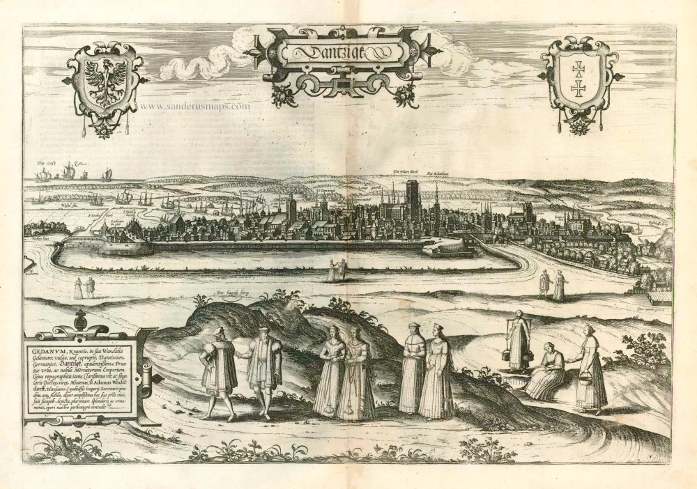
Dantzigk - Gedanum, Krantio, in sua Wandalia Gdanum; . . . 1576
Gdansk, by Georg Braun and Frans Hogenberg.
[Item number: 4056]
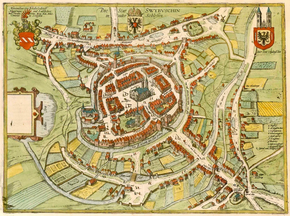
Die Stat Swybuschin in Nider Schlesien. 1596
Poland - Swiebodzin, by Braun & Hogenberg.
[Item number: 22102]
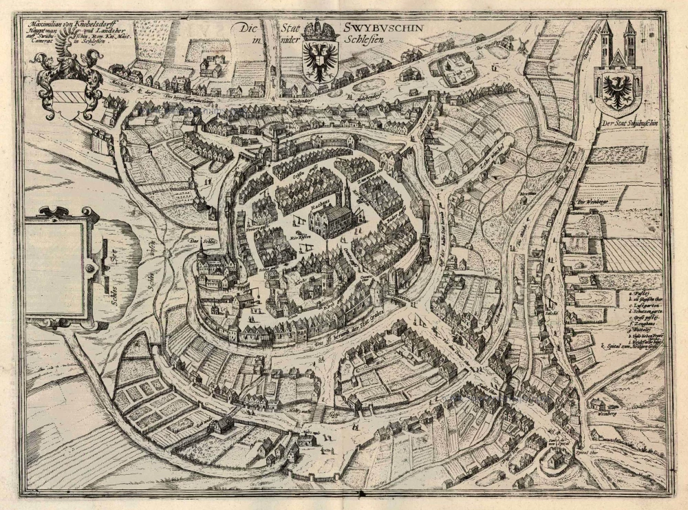
Die Stat Swybuschin in Nider Schlesien 1596
Swiebodzin, by Georg Braun and Frans Hogenberg.
[Item number: 24182]
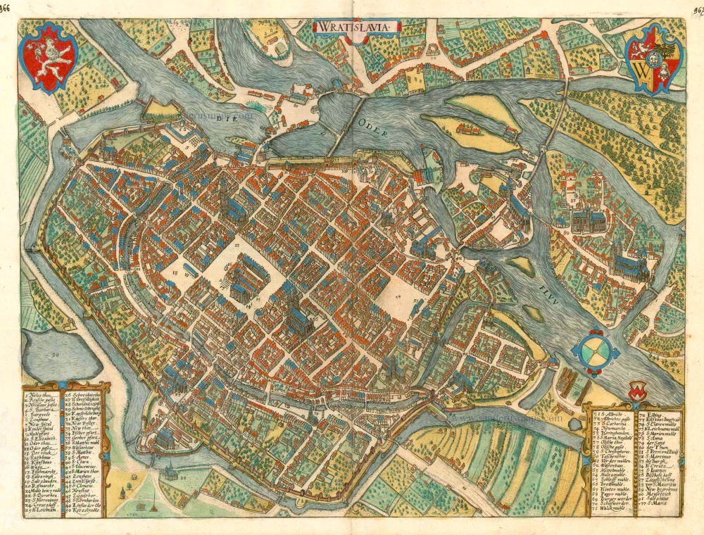
Wratislavia. c. 1593
Wroclaw (Breslau), by Georg Braun and Frans Hogenberg.
[Item number: 24572]
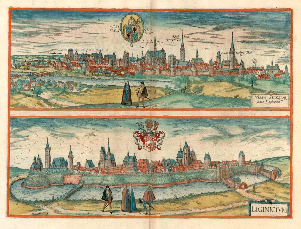
Nissa Silesior Sedes Episcopalis [on sheet with] Liginicium c. 1625
Nysa and Legnica (Poland), by Georg Braun and Frans Hogenberg.
[Item number: 24584]
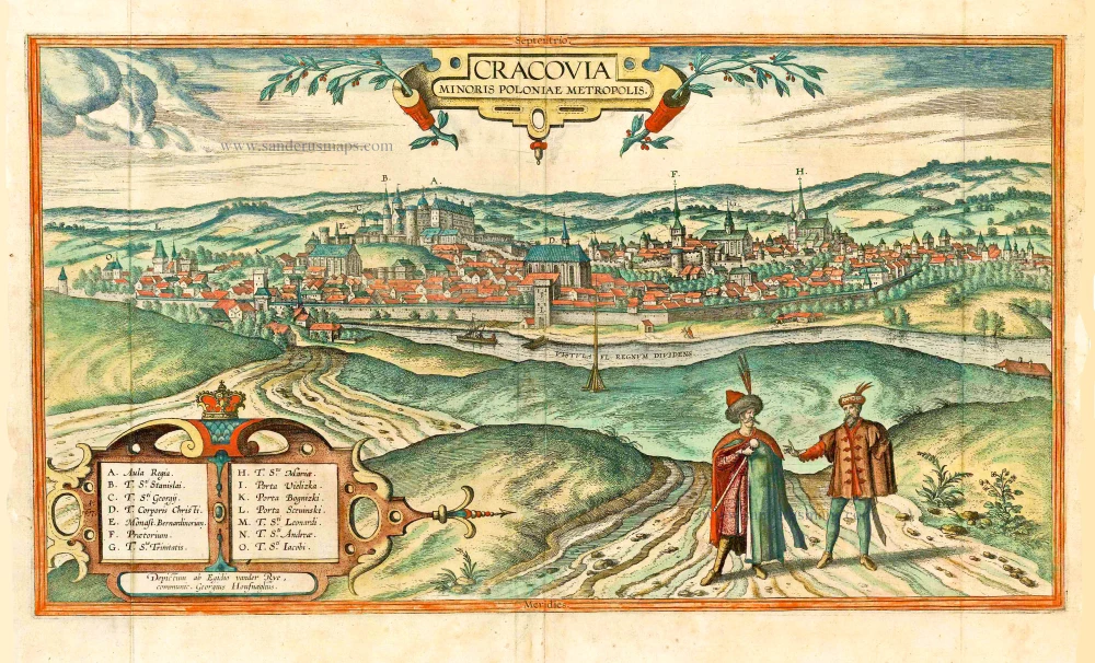
Cracovia Minoris Poloniae Metropolis. 1617-18
Krakow, by Georg Braun and Frans Hogenberg. after G. Hoefnagel and E. vander Rye.
[Item number: 25150]
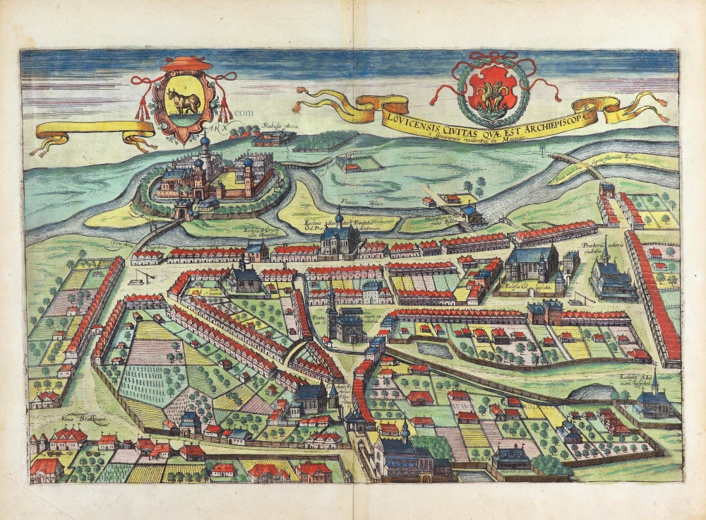
Lovicensis Civitas quae est Archiepiscopa. 1617-18
Lowicz by Georg Braun & Frans Hogenberg
[Item number: 29282]
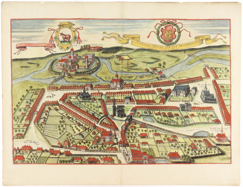
Lovicensis Civitas quae est Archiepiscopa. 1617-18
Lowicz by Georg Braun & Frans Hogenberg
[Item number: 30934]