
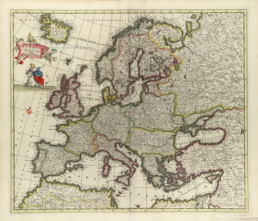
Europe, by Matthias Quad. 1600

Matthias Quad (Deventer, 1557 – Eppingen, 1613)
Matthias Quad, born in Deventer in 1557, was trained there as an engraver by the Van Deutecum brothers. He also studied with Hendrick Goltzius in Haarlem. Later, he settled in Germany after spending some time in France and England.
He lived in Cologne since 1587, where he met the renowned engraver and mapmaker Frans Hogenberg and the printer and publisher Johann Bussemacher. For the next 15 years, Quad worked closely with Bussemacher, especially in publishing atlases. In 1592, he published a translation of an atlas by Botero, and in the following years, several geographical works followed.
With Bussemacher, he prepared a hand and travel atlas in a small format, for which he primarily focused on engraving. From 1592, they published some editions under the name of Bussemacher without text. In 1594, the Europae … descriptio appeared as an atlas with 50 maps with text by Quad. Bussemacher printed the maps, but the text was printed by Lambert Andreae, with whom Bussemacher often collaborated. In 1600, the Geographisch Handtbuch, a world atlas featuring 82 maps, was published.
From that time on, Quad released a series of Itineraries. The Deliciae Germaniae (1600), the Deliciae Galliae (1600), the Itinearium universae Germaniae (1602), and others on Northern Europe, Italy and Spain.
He spent the last years of his life as a teacher in Eppingen, where he died in 1613.
Europa.
Item Number: 26666 Authenticity Guarantee
Category: Antique maps > Europe > Europe Continent
Old, antique map of Europe, by M. Quad, engraved by J. Bussemacher.
Date of the first edition: 1592
Date of this map: c.1600
Copper engraving, printed on paper.
Size (not including margins): 19.5 x 26.5cm (7.6 x 10.4 inches)
Verso text: Blank
Condition: Several folds, short margins (3-7mm).
Condition Rating: A
References: Meurer (Cologne), Qua 1.
Matthias Quad (Deventer, 1557 – Eppingen, 1613)
Matthias Quad, born in Deventer in 1557, was trained there as an engraver by the Van Deutecum brothers. He also studied with Hendrick Goltzius in Haarlem. Later, he settled in Germany after spending some time in France and England.
He lived in Cologne since 1587, where he met the renowned engraver and mapmaker Frans Hogenberg and the printer and publisher Johann Bussemacher. For the next 15 years, Quad worked closely with Bussemacher, especially in publishing atlases. In 1592, he published a translation of an atlas by Botero, and in the following years, several geographical works followed.
With Bussemacher, he prepared a hand and travel atlas in a small format, for which he primarily focused on engraving. From 1592, they published some editions under the name of Bussemacher without text. In 1594, the Europae … descriptio appeared as an atlas with 50 maps with text by Quad. Bussemacher printed the maps, but the text was printed by Lambert Andreae, with whom Bussemacher often collaborated. In 1600, the Geographisch Handtbuch, a world atlas featuring 82 maps, was published.
From that time on, Quad released a series of Itineraries. The Deliciae Germaniae (1600), the Deliciae Galliae (1600), the Itinearium universae Germaniae (1602), and others on Northern Europe, Italy and Spain.
He spent the last years of his life as a teacher in Eppingen, where he died in 1613.
Related items

Imperii Caroli Magni et Vicinarum Regionum Descriptio ... 1635
Empire of Charlemagne, by Blaeu W.& J.
[Item number: 9393]
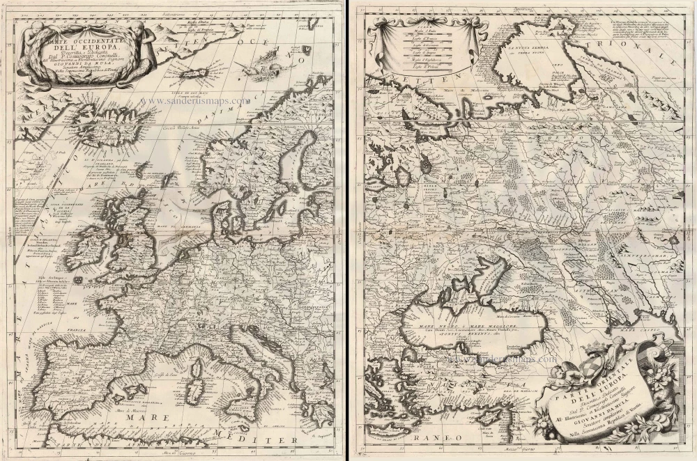
Parte Occidentale dell'Europa ... [in set with] Parte Orientale dell'Europa ... 1691
Europe, by V.M. Coronelli.
[Item number: 23186]

Europa Pars Tenet haec Mundi Reliquas Celeberrima Partes c. 1730.
Europe by G.& L. Valk.
[Item number: 24536]

Europa delineata et recens edita. 1683-1696
Europe by Nicolaas Visscher II.
[Item number: 28712]

Nova et Accurate Divisa in Regna et Regiones Praecipuas Europae Descriptio. c. 1691-96
Europe, by Frederick de Wit;
[Item number: 29233]

Europa Vetus. 1667-69
Ancient Europe by Nicolas & Guillaume Sanson.
[Item number: 30000]
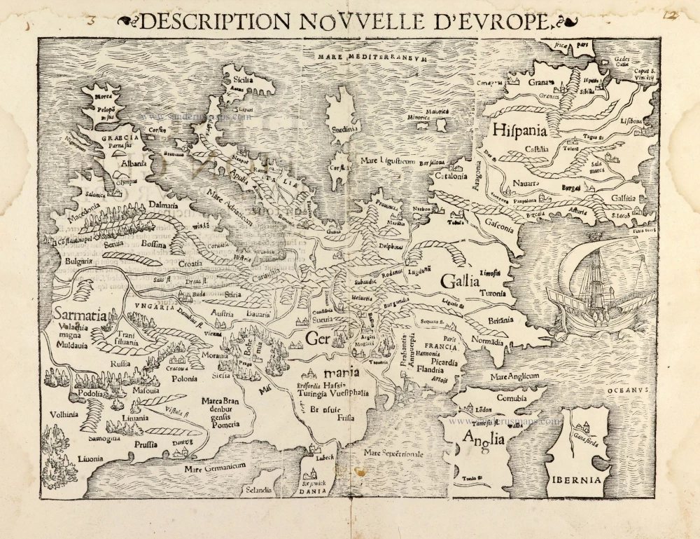
Description Nouvelle d'Europe. 1568
Europe by Sebastian Münster
[Item number: 30523]

Nobilis Hannoniae Com. Descriptio. 1634
Hainaut by Petrus Kaerius (Pieter Van den Keere), published by Claes Jansz. Visscher.
[Item number: 30736]

Scarce map
Europam sive Celticam Veterem c. 1630-1650
Europe by Evert van Hamersveldt, published by Johannes Janssonius.
[Item number: 30838]

Europae. 1612
Europe, by Abraham Ortelius.
[Item number: 30944]

Rare
Nova Totius Europae Tabula ex magnis Gerardi de Iudaeis P. desumpta 1593
Europe by Cornelis de Jode
[Item number: 30946]

L'Europe Divisée Suivant l'Estendue de ses Principaux Estats subdivisés en leurs principales Provinces. 1692
Europe, by N. Sanson, so-called published by Hubert Jaillot. (Pirated edition by Pierre Mortier).
[Item number: 31138]
Accuratissima Europae Tabula. 1696-1713
Europe by J. Danckerts.
[Item number: 32457]

L' Europa. 1677
Europe by Giovanni De Rossi, after Nicolas Sanson.
[Item number: 32886]

Europa, ad Magnae Europae Gerardi Mercatoris P. Imitationem, Rumoldi Mercatoris F. Cura Edita, Seruato Tamen Initio Longitudinis ex Ratione Magnetis, quod Pater in Magna sua Universali Posuit. 1613
Europe by Gerard Mercator.
[Item number: 32928]

Scarce
Nova Europa Descriptio. 1689-90
Europe by Frederick de Wit
[Item number: 32974]

Carte de L'Europe, corrigée et augmentée dessus toutes les autres cy devant faictes c. 1630-1650
Europe by Petrus Bertius, published by Melchior Tavernier.
[Item number: 33121]
new