
Heidelberg - Speyer - Worms by Braun & Hogenberg 1574
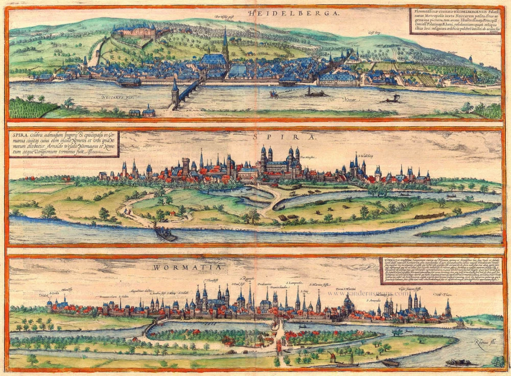
HEIDELBERG
TRANSLATION OF CARTOUCHE TEXT: The location and faithful likeness of the flourishing city of Heidelberg, the capital of the Palatinate beside the Neckar, the castle of the most illustrious princes, the Counts Palatine of the Rhine, and other major buildings are presented to the eyes of the viewer.
COMMENTARY BY BRAUN: "Heidelberg on the Neckar is the seat of the princes and Counts Palatine of the Rhine. Its name is thought to come from the heathens [German Heiden] who lived here, as can be seen from many signs, or in the opinion of Franciscus Irenicus derives from the bilberries [German Heidelbeeren] that grow all over the hillside. [...] In Heidelberg there is also a famous university, founded by the first rector, Marsilius, and in the year 1386 subsequently granted substantial rights by Duke Rupert. A fortress once stood on Allerheiligen Mountain, and a church is also supposed to have existed there, called the Pantheon, which in pagan times was dedicated to all the gods."
The view of the city and castle overlooking the Neckar is presented from the slightly elevated path known as the Philosopher's Way. Those familiar with Heidelberg will easily recognize the layout of the Old Town as it still exists today. The church of the Holy Ghost (Der Hylig Geist) housed the famous Biblioteca Palatina, a library of medieval manuscripts and early printed books. In 1620, during the Thirty Year's War, these were seized by Elector Maximilian I and presented as a gift to Pope Gregory XV. Heidelberg saw its first flowering in 1356, when Count Palatine Rupert I was granted the rank of Elector. The founding of the university in 1386 attracted many scholars in its wake, and the Heidelberg court would later become a meeting point for humanists during the Reformation. At the start of the 15th century Heidelberg occupied the area of the present Old Town as far as Bismarckplatz. The city nevertheless had an estimated population of only 6,300 around 1590 and thereby lagged far behind cities such as Cologne and Nuremberg.
The view has been made after a woodcut in Münster's Cosmographia, 1550.
SPEYER
CARTOUCHE: Speyer, the very famous imperial and episcopal city, whose inhabitants were formerly called Nemetes and the city itself Nemetum.
COMMENTARY BY BRAUN: "Speyer is an old city, it was developed with such magnificence by Emperor Conrad II that he was called the second builder of Speyer. In this city there is a consortium in which, at the instigation of Emperor Charles V, many celebrated and highly learned and wise doctors and lawyers hear appeals that are brought from other courts, on behalf of the Emperor and the Electors."
Speyer is seen from the banks of the Rhine. The tallest steeple on the left belongs to the monastery of St German. In the centre, captioned Das Münster, is the imperial cathedral, one of the most important Romanesque buildings in Germany. In the first half of the 16th century Speyer hosted several important imperial diets, e.g. in 1526, when it was resolved to move the imperial chamber court to Speyer, and in 1529, when the 19 Lutheran imperial states protested against the imperial ban placed upon Luther and his supporters in the Edict of Worms and against the restrictions to the Lutheran (i.e. Protestant) faith.
The view is engraved after a woodcut by Heinrich Holtzmüller, which appeared in Münster's Cosmographia, 1550.
WORMS
CARTOUCHE: Worms, ancient city of the Vangiones on the Rhine, is situated in the best and most fertile place, where a number of legends have also sprung up around it [...]. Theodore of Berne, according to one of these legends, is supposed the have killed the giantess who planted the rose garden here, which no one was permitted to enter and was lethally dangerous. That the garden is said to have been here signifies that Worms is located in the loveliest part of almost all Germany and virtually in its centre. Also living at the time of King Theodore, however, was Attila, king of the Huns, who after destroying many lands finally also advanced in a towering rage against Germany and Gaul. Theodore, king of the Goths, moved against him to support the Roman consul Aelius and drove Attila completely out of Gaul and Germany. From distances given in old itineraries, it is satisfactorily established that the city was formerly called Borbetomagus or according to others Brethomagnus, then Rufiniana.
COMMENTARY BY BRAUN: "Worms was destroyed by a devastating fire during the time of Emperor Charlemagne. At that time Worms was an archbishopric; in AD 782 this passed to Mainz. Worms has always remained a bishopric, however, which competes in age with other German bishoprics. A number of church councils and imperial diets have been held here."
The view across the Rhine shows a well-fortified city with numerous churches and handsome private residences. Rising from the city centre's highest point is St Peter's cathedral (Thumstifft). Amongst the churches on either side are (right) St Paul's, St Rupert's, the Dominican monastery (Predicatores), St Martin's and the Liebfrauenkirche, and (left) St Andrew's. A number of historic decisions were reached in Worms in the late 15th/early 16th century: a diet held here by Emperor Maximilian in 1495 saw the introduction of the Imperial Chamber Court and the "Eternal Peace", while at the diet of 1521 Martin Luther was summoned to defend his 95 theses and Emperor Charles V issued the Edict of Worms outlawing Luther and his supporters.
The view is engraved after a woodcut in Münster's Cosmographia, 1550.
Braun G. & Hogenberg F. and the Civitates Orbis Terrarum.
The Civitates Orbis Terrarum, also known as the 'Braun & Hogenberg', is a six-volume town atlas and the most excellent book of town views and plans ever published: 363 engravings, sometimes beautifully coloured. It was one of the best-selling works in the last quarter of the 16th century. Georg Braun, a skilled writer, wrote the text accompanying the plans and views on the verso. Many plates were engraved after the original drawings of a professional artist, Joris Hoefnagel (1542-1600). The first volume was published in Latin in 1572 and the sixth in 1617. Frans Hogenberg, a talented engraver, created the tables for volumes I through IV, and Simon van den Neuwel made those for volumes V and VI. Other contributors were cartographers Daniel Freese and Heinrich Rantzau, who provided valuable geographical information. Works by Jacob van Deventer, Sebastian Münster, and Johannes Stumpf were also used as references. Translations appeared in German and French, making the atlas accessible to a wider audience.
Since its original publication of volume 1 in 1572, the Civitates Orbis Terrarum has left an indelible mark on the history of cartography. The first volume was followed by seven more editions in 1575, 1577, 1582, 1588, 1593, 1599, and 1612. Vol.2, initially released in 1575, saw subsequent editions in 1597 and 1612. The subsequent volumes, each a treasure trove of historical insights, graced the world in 1581, 1588, 1593, 1599, and 1606. The German translation of the first volume, a testament to its widespread appeal, debuted in 1574, followed by the French edition in 1575.
Several printers were involved: Theodor Graminaeus, Heinrich von Aich, Gottfried von Kempen, Johannis Sinniger, Bertram Buchholtz, and Peter von Brachel, all of whom worked in Cologne.
Georg Braun (1541-1622)
Georg Braun, the author of the text accompanying the plans and views in the Civitates Orbis Terrarum, was born in Cologne in 1541. After his studies in Cologne, he entered the Jesuit Order as a novice, indicating his commitment to learning and intellectual pursuits. In 1561, he obtained his bachelor's degree; in 1562, he received his Magister Artium, further demonstrating his academic achievements. Although he left the Jesuit Order, he continued his studies in theology, gaining a licentiate in theology. His theological background likely influenced the content and tone of the text in the Civitates Orbis Terrarum, adding a unique perspective to the work.
Frans Hogenberg (1535-1590)
Frans Hogenberg was a Flemish and German painter, engraver, and mapmaker. He was born in Mechelen as the son of Nicolaas Hogenberg.
By the end of the 1560s, Frans Hogenberg was employed upon Abraham Ortelius's Theatrum Orbis Terrarum, published in 1570; he is named an engraver of numerous maps. In 1568, he was banned from Antwerp by the Duke of Alva and travelled to London, where he stayed a few years before emigrating to Cologne. He immediately embarked on his two most important works, the Civitates, published in 1572 and the Geschichtsblätter, which appeared in several series from 1569 until about 1587.
Thanks to large-scale projects like the Geschichtsblätter and the Civitates, Hogenberg's social circumstances improved with each passing year. He died as a wealthy man in Cologne in 1590.
Heidelberga - Florentissimae civitatis Heidelbergensis ... [on sheet with] Spira Celebris admodum Imperij & episcopalis in Germania civitas ... [and] Wormacia vetustissima Vangionum civitas ...
Item Number: 5387 Authenticity Guarantee
Category: Antique maps > Europe > Germany - Cities
Antique map with three bird's-eye views by Braun and Hogenberg: Heidelberg, Speyer and Worms.
HEIDELBERG
TRANSLATION OF CARTOUCHE TEXT: The location and faithful likeness of the flourishing city of Heidelberg, the capital of the Palatinate beside the Neckar, the castle of the most illustrious princes, the Counts Palatine of the Rhine, and other major buildings are presented to the eyes of the viewer.
COMMENTARY BY BRAUN: "Heidelberg on the Neckar is the seat of the princes and Counts Palatine of the Rhine. Its name is thought to come from the heathens [German Heiden] who lived here, as can be seen from many signs, or in the opinion of Franciscus Irenicus derives from the bilberries [German Heidelbeeren] that grow all over the hillside. [...] In Heidelberg there is also a famous university, founded by the first rector, Marsilius, and in the year 1386 subsequently granted substantial rights by Duke Rupert. A fortress once stood on Allerheiligen Mountain, and a church is also supposed to have existed there, called the Pantheon, which in pagan times was dedicated to all the gods."
The view of the city and castle overlooking the Neckar is presented from the slightly elevated path known as the Philosopher's Way. Those familiar with Heidelberg will easily recognize the layout of the Old Town as it still exists today. The church of the Holy Ghost (Der Hylig Geist) housed the famous Biblioteca Palatina, a library of medieval manuscripts and early printed books. In 1620, during the Thirty Year's War, these were seized by Elector Maximilian I and presented as a gift to Pope Gregory XV. Heidelberg saw its first flowering in 1356, when Count Palatine Rupert I was granted the rank of Elector. The founding of the university in 1386 attracted many scholars in its wake, and the Heidelberg court would later become a meeting point for humanists during the Reformation. At the start of the 15th century Heidelberg occupied the area of the present Old Town as far as Bismarckplatz. The city nevertheless had an estimated population of only 6,300 around 1590 and thereby lagged far behind cities such as Cologne and Nuremberg.
The view has been made after a woodcut in Münster's Cosmographia, 1550.
SPEYER
CARTOUCHE: Speyer, the very famous imperial and episcopal city, whose inhabitants were formerly called Nemetes and the city itself Nemetum.
COMMENTARY BY BRAUN: "Speyer is an old city, it was developed with such magnificence by Emperor Conrad II that he was called the second builder of Speyer. In this city there is a consortium in which, at the instigation of Emperor Charles V, many celebrated and highly learned and wise doctors and lawyers hear appeals that are brought from other courts, on behalf of the Emperor and the Electors."
Speyer is seen from the banks of the Rhine. The tallest steeple on the left belongs to the monastery of St German. In the centre, captioned Das Münster, is the imperial cathedral, one of the most important Romanesque buildings in Germany. In the first half of the 16th century Speyer hosted several important imperial diets, e.g. in 1526, when it was resolved to move the imperial chamber court to Speyer, and in 1529, when the 19 Lutheran imperial states protested against the imperial ban placed upon Luther and his supporters in the Edict of Worms and against the restrictions to the Lutheran (i.e. Protestant) faith.
The view is engraved after a woodcut by Heinrich Holtzmüller, which appeared in Münster's Cosmographia, 1550.
WORMS
CARTOUCHE: Worms, ancient city of the Vangiones on the Rhine, is situated in the best and most fertile place, where a number of legends have also sprung up around it [...]. Theodore of Berne, according to one of these legends, is supposed the have killed the giantess who planted the rose garden here, which no one was permitted to enter and was lethally dangerous. That the garden is said to have been here signifies that Worms is located in the loveliest part of almost all Germany and virtually in its centre. Also living at the time of King Theodore, however, was Attila, king of the Huns, who after destroying many lands finally also advanced in a towering rage against Germany and Gaul. Theodore, king of the Goths, moved against him to support the Roman consul Aelius and drove Attila completely out of Gaul and Germany. From distances given in old itineraries, it is satisfactorily established that the city was formerly called Borbetomagus or according to others Brethomagnus, then Rufiniana.
COMMENTARY BY BRAUN: "Worms was destroyed by a devastating fire during the time of Emperor Charlemagne. At that time Worms was an archbishopric; in AD 782 this passed to Mainz. Worms has always remained a bishopric, however, which competes in age with other German bishoprics. A number of church councils and imperial diets have been held here."
The view across the Rhine shows a well-fortified city with numerous churches and handsome private residences. Rising from the city centre's highest point is St Peter's cathedral (Thumstifft). Amongst the churches on either side are (right) St Paul's, St Rupert's, the Dominican monastery (Predicatores), St Martin's and the Liebfrauenkirche, and (left) St Andrew's. A number of historic decisions were reached in Worms in the late 15th/early 16th century: a diet held here by Emperor Maximilian in 1495 saw the introduction of the Imperial Chamber Court and the "Eternal Peace", while at the diet of 1521 Martin Luther was summoned to defend his 95 theses and Emperor Charles V issued the Edict of Worms outlawing Luther and his supporters.
The view is engraved after a woodcut in Münster's Cosmographia, 1550.
Date of the first edition: 1572
Date of this map: 1574
Copper engraving, printed on paper.
Size (not including margins): 35 x 47.5cm (13.7 x 18.5 inches)
Verso text: German
Condition: Original coloured, slight discoloration at fold.
Condition Rating: A
References: Van der Krogt 4, 1751, State 1 (Without privilege); Taschen, Br. Hog., p.91; Fauser, #5547 - #13195 - #15692
From: Beschreibung und Contrafactur der Vornembster Stät der Welt. Köln, Heinrich von Ach, 1574. (Van der Krogt 4, 41:2.1)
HEIDELBERG
TRANSLATION OF CARTOUCHE TEXT: The location and faithful likeness of the flourishing city of Heidelberg, the capital of the Palatinate beside the Neckar, the castle of the most illustrious princes, the Counts Palatine of the Rhine, and other major buildings are presented to the eyes of the viewer.
COMMENTARY BY BRAUN: "Heidelberg on the Neckar is the seat of the princes and Counts Palatine of the Rhine. Its name is thought to come from the heathens [German Heiden] who lived here, as can be seen from many signs, or in the opinion of Franciscus Irenicus derives from the bilberries [German Heidelbeeren] that grow all over the hillside. [...] In Heidelberg there is also a famous university, founded by the first rector, Marsilius, and in the year 1386 subsequently granted substantial rights by Duke Rupert. A fortress once stood on Allerheiligen Mountain, and a church is also supposed to have existed there, called the Pantheon, which in pagan times was dedicated to all the gods."
The view of the city and castle overlooking the Neckar is presented from the slightly elevated path known as the Philosopher's Way. Those familiar with Heidelberg will easily recognize the layout of the Old Town as it still exists today. The church of the Holy Ghost (Der Hylig Geist) housed the famous Biblioteca Palatina, a library of medieval manuscripts and early printed books. In 1620, during the Thirty Year's War, these were seized by Elector Maximilian I and presented as a gift to Pope Gregory XV. Heidelberg saw its first flowering in 1356, when Count Palatine Rupert I was granted the rank of Elector. The founding of the university in 1386 attracted many scholars in its wake, and the Heidelberg court would later become a meeting point for humanists during the Reformation. At the start of the 15th century Heidelberg occupied the area of the present Old Town as far as Bismarckplatz. The city nevertheless had an estimated population of only 6,300 around 1590 and thereby lagged far behind cities such as Cologne and Nuremberg.
The view has been made after a woodcut in Münster's Cosmographia, 1550.
SPEYER
CARTOUCHE: Speyer, the very famous imperial and episcopal city, whose inhabitants were formerly called Nemetes and the city itself Nemetum.
COMMENTARY BY BRAUN: "Speyer is an old city, it was developed with such magnificence by Emperor Conrad II that he was called the second builder of Speyer. In this city there is a consortium in which, at the instigation of Emperor Charles V, many celebrated and highly learned and wise doctors and lawyers hear appeals that are brought from other courts, on behalf of the Emperor and the Electors."
Speyer is seen from the banks of the Rhine. The tallest steeple on the left belongs to the monastery of St German. In the centre, captioned Das Münster, is the imperial cathedral, one of the most important Romanesque buildings in Germany. In the first half of the 16th century Speyer hosted several important imperial diets, e.g. in 1526, when it was resolved to move the imperial chamber court to Speyer, and in 1529, when the 19 Lutheran imperial states protested against the imperial ban placed upon Luther and his supporters in the Edict of Worms and against the restrictions to the Lutheran (i.e. Protestant) faith.
The view is engraved after a woodcut by Heinrich Holtzmüller, which appeared in Münster's Cosmographia, 1550.
WORMS
CARTOUCHE: Worms, ancient city of the Vangiones on the Rhine, is situated in the best and most fertile place, where a number of legends have also sprung up around it [...]. Theodore of Berne, according to one of these legends, is supposed the have killed the giantess who planted the rose garden here, which no one was permitted to enter and was lethally dangerous. That the garden is said to have been here signifies that Worms is located in the loveliest part of almost all Germany and virtually in its centre. Also living at the time of King Theodore, however, was Attila, king of the Huns, who after destroying many lands finally also advanced in a towering rage against Germany and Gaul. Theodore, king of the Goths, moved against him to support the Roman consul Aelius and drove Attila completely out of Gaul and Germany. From distances given in old itineraries, it is satisfactorily established that the city was formerly called Borbetomagus or according to others Brethomagnus, then Rufiniana.
COMMENTARY BY BRAUN: "Worms was destroyed by a devastating fire during the time of Emperor Charlemagne. At that time Worms was an archbishopric; in AD 782 this passed to Mainz. Worms has always remained a bishopric, however, which competes in age with other German bishoprics. A number of church councils and imperial diets have been held here."
The view across the Rhine shows a well-fortified city with numerous churches and handsome private residences. Rising from the city centre's highest point is St Peter's cathedral (Thumstifft). Amongst the churches on either side are (right) St Paul's, St Rupert's, the Dominican monastery (Predicatores), St Martin's and the Liebfrauenkirche, and (left) St Andrew's. A number of historic decisions were reached in Worms in the late 15th/early 16th century: a diet held here by Emperor Maximilian in 1495 saw the introduction of the Imperial Chamber Court and the "Eternal Peace", while at the diet of 1521 Martin Luther was summoned to defend his 95 theses and Emperor Charles V issued the Edict of Worms outlawing Luther and his supporters.
The view is engraved after a woodcut in Münster's Cosmographia, 1550.
Braun G. & Hogenberg F. and the Civitates Orbis Terrarum.
The Civitates Orbis Terrarum, also known as the 'Braun & Hogenberg', is a six-volume town atlas and the most excellent book of town views and plans ever published: 363 engravings, sometimes beautifully coloured. It was one of the best-selling works in the last quarter of the 16th century. Georg Braun, a skilled writer, wrote the text accompanying the plans and views on the verso. Many plates were engraved after the original drawings of a professional artist, Joris Hoefnagel (1542-1600). The first volume was published in Latin in 1572 and the sixth in 1617. Frans Hogenberg, a talented engraver, created the tables for volumes I through IV, and Simon van den Neuwel made those for volumes V and VI. Other contributors were cartographers Daniel Freese and Heinrich Rantzau, who provided valuable geographical information. Works by Jacob van Deventer, Sebastian Münster, and Johannes Stumpf were also used as references. Translations appeared in German and French, making the atlas accessible to a wider audience.
Since its original publication of volume 1 in 1572, the Civitates Orbis Terrarum has left an indelible mark on the history of cartography. The first volume was followed by seven more editions in 1575, 1577, 1582, 1588, 1593, 1599, and 1612. Vol.2, initially released in 1575, saw subsequent editions in 1597 and 1612. The subsequent volumes, each a treasure trove of historical insights, graced the world in 1581, 1588, 1593, 1599, and 1606. The German translation of the first volume, a testament to its widespread appeal, debuted in 1574, followed by the French edition in 1575.
Several printers were involved: Theodor Graminaeus, Heinrich von Aich, Gottfried von Kempen, Johannis Sinniger, Bertram Buchholtz, and Peter von Brachel, all of whom worked in Cologne.
Georg Braun (1541-1622)
Georg Braun, the author of the text accompanying the plans and views in the Civitates Orbis Terrarum, was born in Cologne in 1541. After his studies in Cologne, he entered the Jesuit Order as a novice, indicating his commitment to learning and intellectual pursuits. In 1561, he obtained his bachelor's degree; in 1562, he received his Magister Artium, further demonstrating his academic achievements. Although he left the Jesuit Order, he continued his studies in theology, gaining a licentiate in theology. His theological background likely influenced the content and tone of the text in the Civitates Orbis Terrarum, adding a unique perspective to the work.
Frans Hogenberg (1535-1590)
Frans Hogenberg was a Flemish and German painter, engraver, and mapmaker. He was born in Mechelen as the son of Nicolaas Hogenberg.
By the end of the 1560s, Frans Hogenberg was employed upon Abraham Ortelius's Theatrum Orbis Terrarum, published in 1570; he is named an engraver of numerous maps. In 1568, he was banned from Antwerp by the Duke of Alva and travelled to London, where he stayed a few years before emigrating to Cologne. He immediately embarked on his two most important works, the Civitates, published in 1572 and the Geschichtsblätter, which appeared in several series from 1569 until about 1587.
Thanks to large-scale projects like the Geschichtsblätter and the Civitates, Hogenberg's social circumstances improved with each passing year. He died as a wealthy man in Cologne in 1590.
Related items
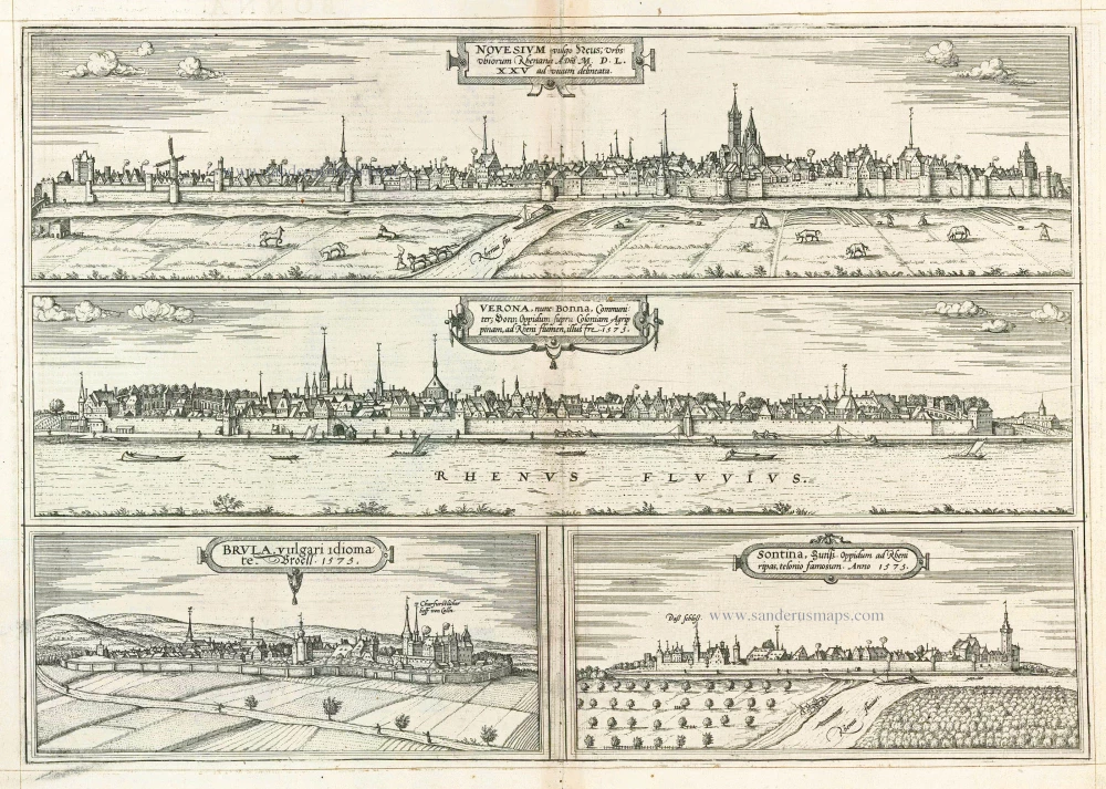
Novesium vulgo Neus ... [on sheet with:] Verona, nunc Bonna, ... [and] Brula, vulgari idiomate Broell; 1575. [and] Sontina, Zunss Oppidum ad Rheni ripas, ... 1575
Neuss, Bonn, Brühl and Zons, by Georg Braun and Frans Hogenberg.
[Item number: 8145]
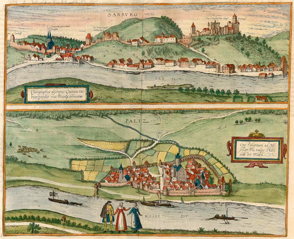
Chorographica descriptio Civitatis Sarburgensis [on sheet with] Opp: Palatinum ad Mosellam Flu; vulgo Pfaltz auff der Musell. 1596-1640
Saarburg - Pfalzel, by Braun & Hogenberg.
[Item number: 22079]
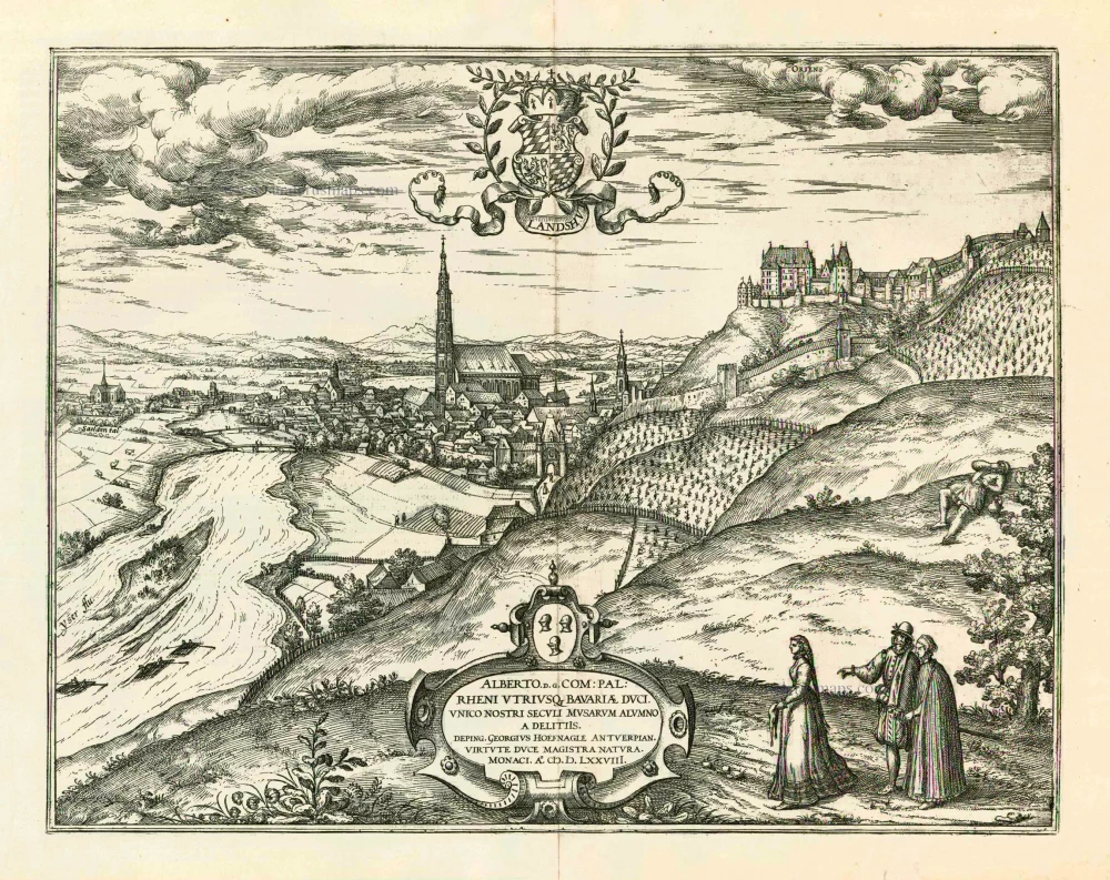
Landshut 1599
Landshut, by Georg Braun and Frans Hogenberg.
[Item number: 24060]
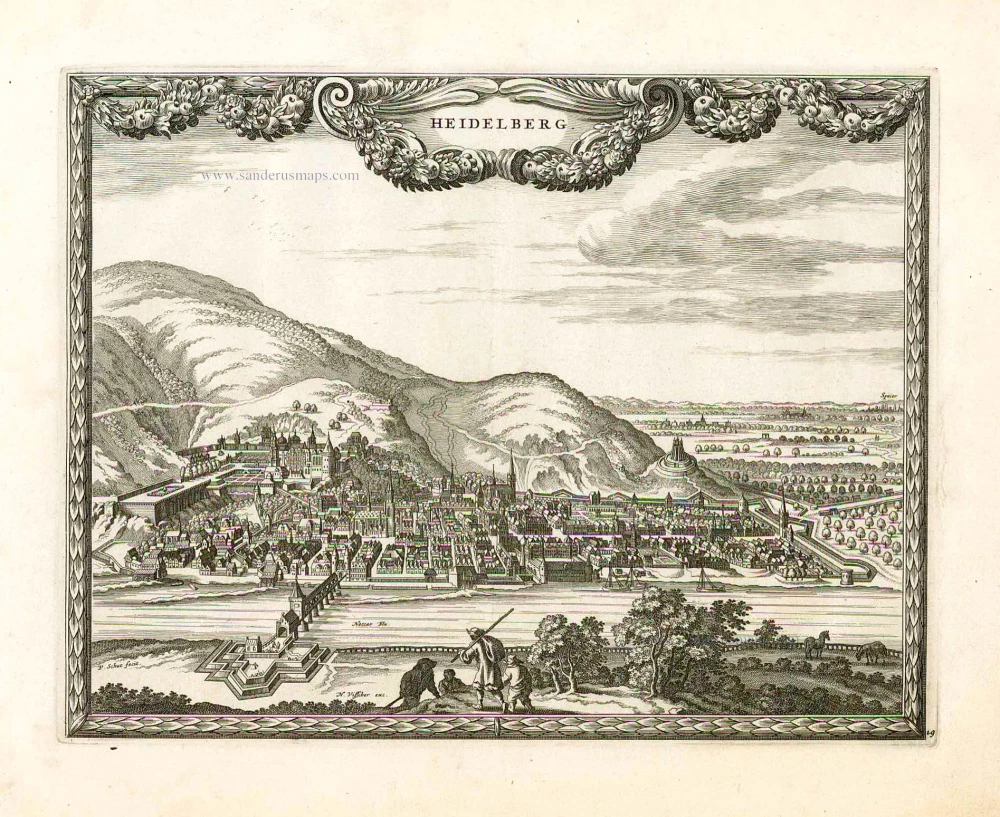
Heidelberg. 1658/60
Heidelberg by Nicolaes Visscher & Pieter Hendricksz. Schut
[Item number: 26647]
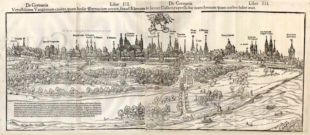
Vetustissima Vangionum civitas, quam hodie Wormaciam, sita ad Rhenum in littore Gallico, expressa hic iuxta formam quam nostro habet aevo. 1552
Worms, by Sebastian Münster.
[Item number: 26802]
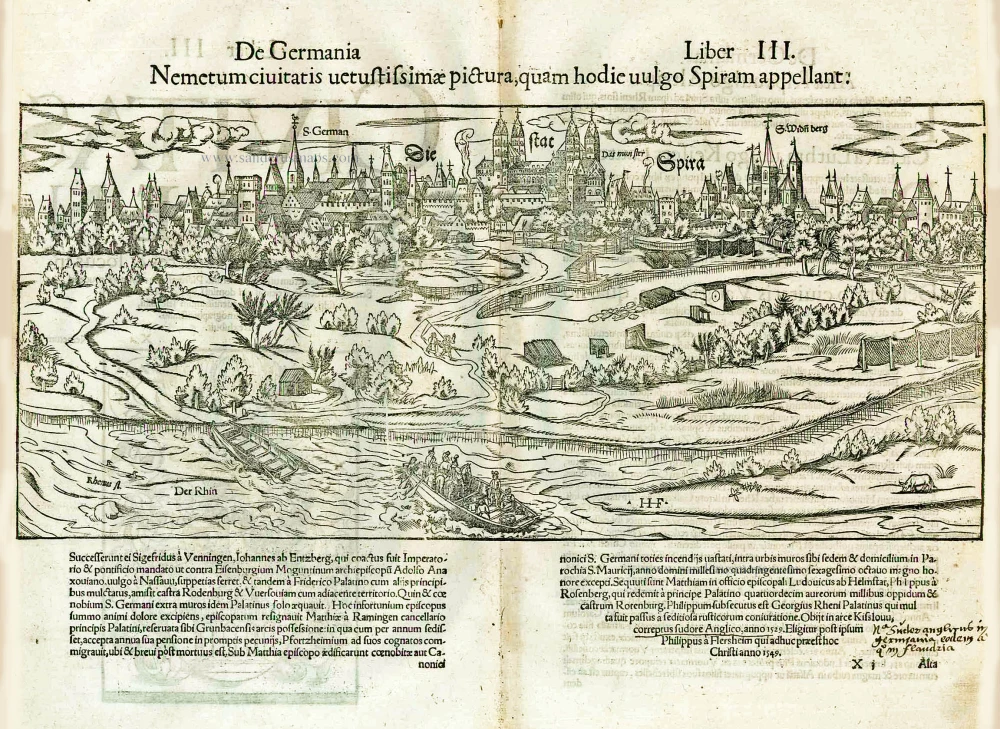
Die Stat Spira. - [Above:] Nemetum civitatis vetustissimae pictura, quam hodie vulgo Spiram appellant. 1552
Speyer, by Sebastian Münster.
[Item number: 26849]