
Greece, by Matthias Quad. 1608

Matthias Quad (Deventer, 1557 – Eppingen, 1613)
Matthias Quad, born in Deventer in 1557, was trained there as an engraver by the Van Deutecum brothers. He also studied with Hendrick Goltzius in Haarlem. Later, he settled in Germany after spending some time in France and England.
He lived in Cologne since 1587, where he met the renowned engraver and mapmaker Frans Hogenberg and the printer and publisher Johann Bussemacher. For the next 15 years, Quad worked closely with Bussemacher, especially in publishing atlases. In 1592, he published a translation of an atlas by Botero, and in the following years, several geographical works followed.
With Bussemacher, he prepared a hand and travel atlas in a small format, for which he primarily focused on engraving. From 1592, they published some editions under the name of Bussemacher without text. In 1594, the Europae … descriptio appeared as an atlas with 50 maps with text by Quad. Bussemacher printed the maps, but the text was printed by Lambert Andreae, with whom Bussemacher often collaborated. In 1600, the Geographisch Handtbuch, a world atlas featuring 82 maps, was published.
From that time on, Quad released a series of Itineraries. The Deliciae Germaniae (1600), the Deliciae Galliae (1600), the Itinearium universae Germaniae (1602), and others on Northern Europe, Italy and Spain.
He spent the last years of his life as a teacher in Eppingen, where he died in 1613.
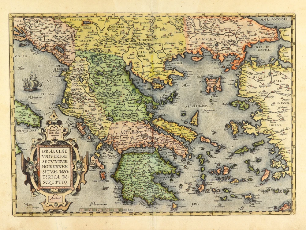
Graeciae Universae Secundum Hodiernum Situm Neoterica Descriptio. Jacobo Castaldo Pedemontano Autore.
Item Number: 18856 Authenticity Guarantee
Category: Antique maps > Europe > Greece & Greek Islands
Old, antique map of Greece, by Matthias Quad.
Title: Graeciae Universae Secundum Hodiernum Situm Neoterica Descriptio. Jacobo Castaldo Pedemontano Autore.
Cartographer: Gastaldi.
Date of the first edition: 1592.
Date of this map: 1608.
Copper engraving, printed on paper.
Size (not including margins): 223 x 285mm (8.78 x 11.22 inches).
Verso: Latin text.
Condition: Original coloured, excellent.
Condition Rating: A+.
From: Fasciculus Geographicus Complectens Praeciparum Totius orbis Regionum tabulas circiter centum. una cum earundum Enarrationibus. Cologne, J. Bussemacher, 1608. (Meurer (Cologne), Qua 7)
Matthias Quad (Deventer, 1557 – Eppingen, 1613)
Matthias Quad, born in Deventer in 1557, was trained there as an engraver by the Van Deutecum brothers. He also studied with Hendrick Goltzius in Haarlem. Later, he settled in Germany after spending some time in France and England.
He lived in Cologne since 1587, where he met the renowned engraver and mapmaker Frans Hogenberg and the printer and publisher Johann Bussemacher. For the next 15 years, Quad worked closely with Bussemacher, especially in publishing atlases. In 1592, he published a translation of an atlas by Botero, and in the following years, several geographical works followed.
With Bussemacher, he prepared a hand and travel atlas in a small format, for which he primarily focused on engraving. From 1592, they published some editions under the name of Bussemacher without text. In 1594, the Europae … descriptio appeared as an atlas with 50 maps with text by Quad. Bussemacher printed the maps, but the text was printed by Lambert Andreae, with whom Bussemacher often collaborated. In 1600, the Geographisch Handtbuch, a world atlas featuring 82 maps, was published.
From that time on, Quad released a series of Itineraries. The Deliciae Germaniae (1600), the Deliciae Galliae (1600), the Itinearium universae Germaniae (1602), and others on Northern Europe, Italy and Spain.
He spent the last years of his life as a teacher in Eppingen, where he died in 1613.
Related items

Parergon map
Graecia, Sophiani. 1624
Greece, by Ortelius A.
[Item number: 2050]

Tabula Europae X 1542
Greece, by Sebastian Münster.
[Item number: 14704]

Nova Totius Graeciae descriptio. 1638
Greece, by J. Janssonius.
[Item number: 15357]

Graecia. 1633
Greece, by Gerard Mercator.
[Item number: 16999]

Graeciae Universae Secundum Hodiernum Situm Neoterica Descriptio. 1592
Greece by Abraham Ortelius.
[Item number: 22970]

Graecia Sophiani / Ex conatibus geographicis Abrahami Ortelii Antuerpiensis Ao. 1596 / Judocus Hondius excudit. 1618
Greece, by Bertius P. - Hondius J.
[Item number: 24541]

La nouvelle Grece selon toutes les regions & provinces d'icelle tant deca que de la l'Hellespont. 1555
Greece, by S. Munster.
[Item number: 25168]

L'Ile de Negrepont, autrefois Eubée, dans l'Archipel, avec toutes ses Côtes. 1713
Euboea, by Pieter van der Aa.
[Item number: 26073]

Turquie en Europe. 1713
Greece, by P. Van der Aa.
[Item number: 26076]

Graeciae Antiquae 1776-79
Ancient Greece, by Paolo Santini, after Jean-Baptiste Bourguignon d'Anville.
[Item number: 28108]

Graecia. 1658
Greece by Nicolas Sanson.
[Item number: 28498]

Graeciae Antique Tabula Geographica; 1699-1710
Greece by Nicolas & Guillaume Sanson.
[Item number: 28575]

Danubii Fluvii Sive Turcici Imperii in Europa. c. 1705
Danube and European Ottoman Empire, by Frederick de Wit.
[Item number: 29279]

Carte Historique et Géographique de l'ancienne Grèce, avec les remarques Cursieuses pour l'intelligence de l'Histoire. 1713
Greece by Zacharias Châtelain.
[Item number: 29553]

Graecia - Graeciae Antiquae Tabulam. 1652
Ancient Greece by Nicolas Sanson.
[Item number: 29693]

Arcipelago - [Above map :] Descrittione dell'Arcipelago. 1590
Greece by Thomaso Porcacchi.
[Item number: 29769]

Antiquorum Illyrici Orientalis Episcopatuum Geographica Descriptio. 1679
Ancient Greece by Melchior Tavernier.
[Item number: 30036]
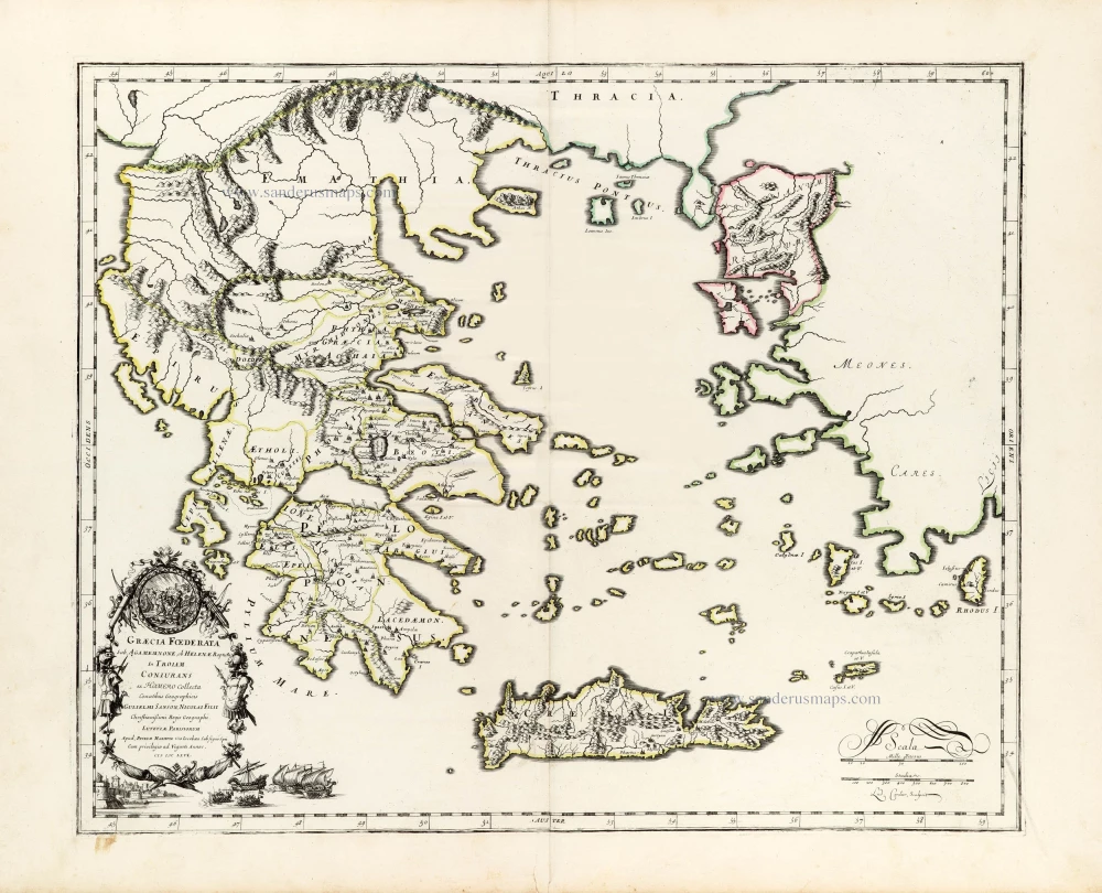
Graecia foederata sub Agamemnone, ob Helenae raptum in Troiam Coniurans ex Homero collecta. 1665
Ancient Greece by Guillaume Sanson.
[Item number: 30039]
Graeciae Universae Secundum Hodiernum Situm Neoterica Descriptio. 1601
Greece by Abraham Ortelius
[Item number: 30623]

La Moree et les Isles de Zante, Cefalonie, Ste Maure, Cerigo &c. 1692
Greece - Peloponnese by N. Sanson, so-called published by Hubert Jaillot. (Pirated edition by Pierre Mortier).
[Item number: 31197]
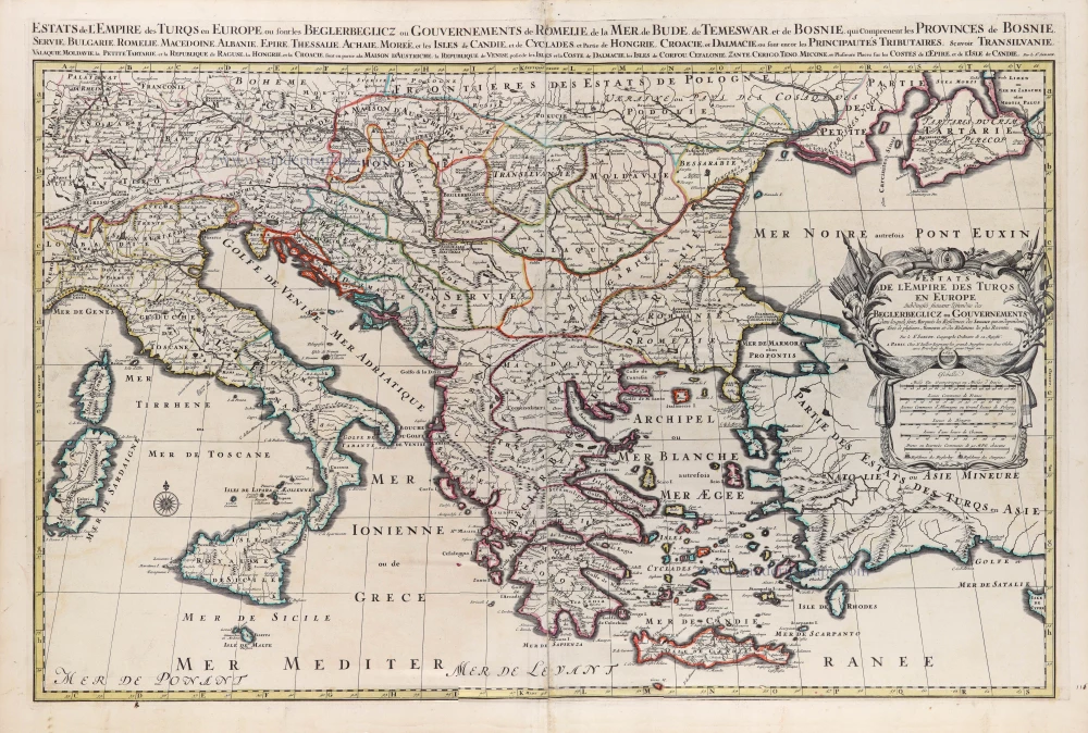
Estats de l'Empire des Turqs en Europe. 1692
European Ottoman Empire by N. Sanson, so-called published by Hubert Jaillot. (Pirated edition by Pierre Mortier).
[Item number: 31199]

Graecia. 1640
Greece, by Joan Blaeu.
[Item number: 31626]

Graecia. 1618
Graecia by Petrus Bertius, published by Jodocus Hondius II.
[Item number: 31852]

Turcicum Imperium. 1618
Ottoman Empire, by Petrus Bertius
[Item number: 32176]

La Grecia divisa nelle sue Provincie. 1779-1785
Greece & Albania, by Antonio Zatta.
[Item number: 32307]

La Grecia Universale Antica Paragonata con la Moderna da Giacomo Cantelli da Vignola 1687
Ancient Greece, by Giacomo Cantelli da Vignola, and published by Giovanni de Rossi.
[Item number: 32956]