
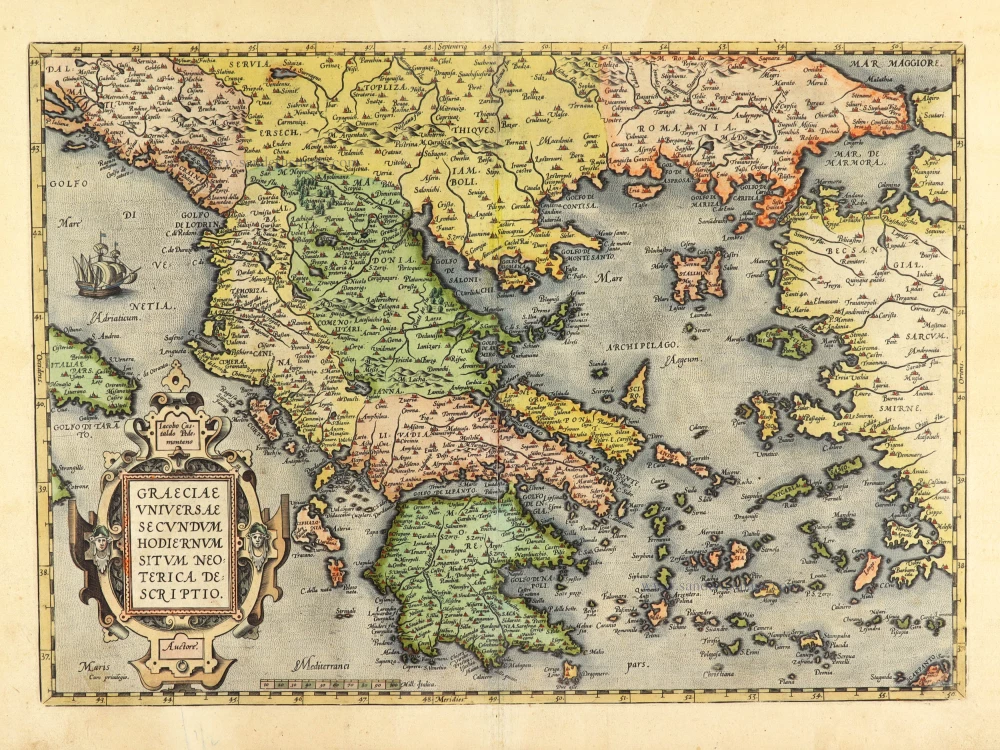
Greece by Thomaso Porcacchi. 1590

Thomaso (Tommaso) Porcacchi (1530-1585)
Thomaso Porcacchi was born in Castiglion Fiorentino (Arentino), Tuscany, into a poor family. Through the patronage of Duke Cosimo I de' Medici, he was able to pursue his studies; afterwards, he embarked on a career as a translator, editor and author, initially in Florence, often working with the humanist scholar Lodovico Domenichi. His speciality was classical texts, particularly of a geographical and historical nature. Through this work, he came into contact with the prominent Venetian publisher Gabriel Giolito de' Ferrari and, in 1559, he moved to Venice to form a fruitful association with Giolito, who had produced several books containing maps.
Later in his career, Porcacchi composed an isolario, L'isole piu famose del mondo ..., published by Simone Galignani de Karera and Girolamo Porro in 1572. In 1574 Porro engraved the plates for another Porcachi volume, Funerali antichi di diversi popoli, et nationi ..., and he later contributed the maps to a new edition of Claudius Prolemy's Geographiae universae tum veteris tum novae ..., edited by Giovanni Antonio Magini and published by the Heirs of Simone Galignani de Karera.
The first edition of Porcacchi's L'isole piu famose contained 30 engraved maps, set in text. The coverage was worldwide, albeit concentrated on the Mediterranean. For the second edition, the text was rewritten, and 17 additional maps were inserted, to make a total of 47.
Arcipelago - [Above map :] Descrittione dell'Arcipelago.
Item Number: 29769 Authenticity Guarantee
Category: Antique maps > Europe > Greece & Greek Islands
Old, antique map of Greece by Thomaso Porcacchi.
Title: Arcipelago - [Above map :] Descrittione dell'Arcipelago.
Engraver: Girolamo Porro.
Date of the first edition: 1572.
Date of this map: 1590.
Copper engraving, printed on paper.
Image size: 105 x 145mm (4.13 x 5.71 inches).
Sheet size: 300 x 200mm (11.81 x 7.87 inches).
Verso: Italian text.
Condition: Excellent.
Condition Rating: A+.
From: Porcacchi T. L'Isole Piu Famose Del Mondo. Venice, Giorgio Angelieri for the Heirs of Simone Galignani, 1590.
Thomaso (Tommaso) Porcacchi (1530-1585)
Thomaso Porcacchi was born in Castiglion Fiorentino (Arentino), Tuscany, into a poor family. Through the patronage of Duke Cosimo I de' Medici, he was able to pursue his studies; afterwards, he embarked on a career as a translator, editor and author, initially in Florence, often working with the humanist scholar Lodovico Domenichi. His speciality was classical texts, particularly of a geographical and historical nature. Through this work, he came into contact with the prominent Venetian publisher Gabriel Giolito de' Ferrari and, in 1559, he moved to Venice to form a fruitful association with Giolito, who had produced several books containing maps.
Later in his career, Porcacchi composed an isolario, L'isole piu famose del mondo ..., published by Simone Galignani de Karera and Girolamo Porro in 1572. In 1574 Porro engraved the plates for another Porcachi volume, Funerali antichi di diversi popoli, et nationi ..., and he later contributed the maps to a new edition of Claudius Prolemy's Geographiae universae tum veteris tum novae ..., edited by Giovanni Antonio Magini and published by the Heirs of Simone Galignani de Karera.
The first edition of Porcacchi's L'isole piu famose contained 30 engraved maps, set in text. The coverage was worldwide, albeit concentrated on the Mediterranean. For the second edition, the text was rewritten, and 17 additional maps were inserted, to make a total of 47.
Related items

Parergon map
Graecia, Sophiani. 1624
Greece, by Ortelius A.
[Item number: 2050]

Tabula Europae X 1542
Greece, by Sebastian Münster.
[Item number: 14704]

Nova Totius Graeciae descriptio. 1638
Greece, by J. Janssonius.
[Item number: 15357]

Graecia. 1633
Greece, by Gerard Mercator.
[Item number: 16999]

Graeciae Universae Secundum Hodiernum Situm Neoterica Descriptio. Jacobo Castaldo Pedemontano Autore. 1608
Greece, by Matthias Quad.
[Item number: 18856]

Graeciae Universae Secundum Hodiernum Situm Neoterica Descriptio. 1592
Greece by Abraham Ortelius.
[Item number: 22970]

La nouvelle Grece selon toutes les regions & provinces d'icelle tant deca que de la l'Hellespont. 1555
Greece, by S. Munster.
[Item number: 25168]

Turquie en Europe. 1713
Greece, by P. Van der Aa.
[Item number: 26076]

Carte de la Grece. 1725-50
Greece by Reinier & Josua Ottens
[Item number: 27699]

Graeciae Antiquae 1776-79
Ancient Greece, by Paolo Santini, after Jean-Baptiste Bourguignon d'Anville.
[Item number: 28108]

Ta Moder Bossinae, Serviae, Graeciae, et Sclavoniae. [From verso] 1525
Greece (Balkan), by Lorenz Fries after Martin Waldseemüller.
[Item number: 28117]

Graecia. 1658
Greece by Nicolas Sanson.
[Item number: 28498]

Graeciae Antique Tabula Geographica; 1699-1710
Greece by Nicolas & Guillaume Sanson.
[Item number: 28575]

Carte Historique et Géographique de l'ancienne Grèce, avec les remarques Cursieuses pour l'intelligence de l'Histoire. 1713
Greece by Zacharias Châtelain.
[Item number: 29553]

Graecia - Graeciae Antiquae Tabulam. 1652
Ancient Greece by Nicolas Sanson.
[Item number: 29693]

Antiquorum Illyrici Orientalis Episcopatuum Geographica Descriptio. 1679
Ancient Greece by Melchior Tavernier.
[Item number: 30036]
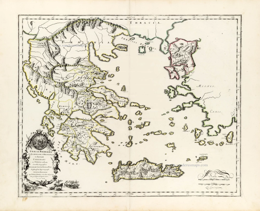
Graecia foederata sub Agamemnone, ob Helenae raptum in Troiam Coniurans ex Homero collecta. 1665
Ancient Greece by Guillaume Sanson.
[Item number: 30039]
Graeciae Universae Secundum Hodiernum Situm Neoterica Descriptio. 1601
Greece by Abraham Ortelius
[Item number: 30623]

La Moree et les Isles de Zante, Cefalonie, Ste Maure, Cerigo &c. 1692
Greece - Peloponnese by N. Sanson, so-called published by Hubert Jaillot. (Pirated edition by Pierre Mortier).
[Item number: 31197]
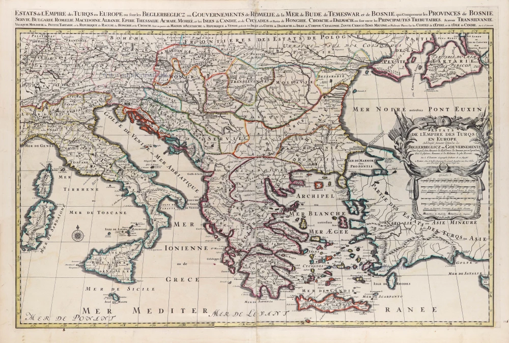
Estats de l'Empire des Turqs en Europe. 1692
European Ottoman Empire by N. Sanson, so-called published by Hubert Jaillot. (Pirated edition by Pierre Mortier).
[Item number: 31199]

Graecia. 1640
Greece, by Joan Blaeu.
[Item number: 31626]

Graecia. 1618
Graecia by Petrus Bertius, published by Jodocus Hondius II.
[Item number: 31852]

Turcicum Imperium. 1618
Ottoman Empire, by Petrus Bertius
[Item number: 32176]

La Grecia divisa nelle sue Provincie. 1779-1785
Greece & Albania, by Antonio Zatta.
[Item number: 32307]

La Grecia Universale Antica Paragonata con la Moderna da Giacomo Cantelli da Vignola 1687
Ancient Greece, by Giacomo Cantelli da Vignola, and published by Giovanni de Rossi.
[Item number: 32956]