
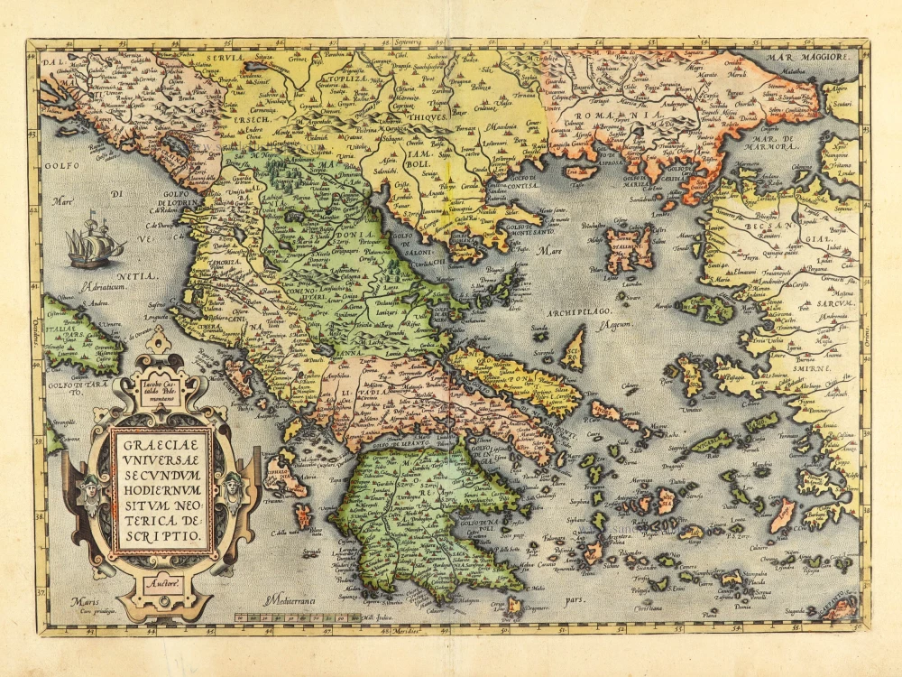
Greece, by S. Munster. 1555

Münster produced sixty-one double-page maps for use in various editions of Ptolemy's Geographia and in his own Cosmographia. Some of these maps appeared in all editions of both works, some only in certain editions. All were woodcut maps with the title supplied in letter-press in the upper margin; these titles varied from edition to edition.
Sebastian Münster (1488-1552)
Sebastian Münster, a German geographer, cartographer, Hebraist, and theologian, was born in Ingelheim, near Mainz In 1505, he went to Heidelberg to enter the Franciscan order. In 1507 he went to Louvain, where he studied mathematics, geography, and astronomy. In 1509 Münster became a student of Konrad Pelikan, who taught Hebrew and Greek as well as mathematics and cosmography. In 1518 he completed his studies at the University of Tübingen. He was the favorite of the famous mathematician and astronomer Johann Stöffler.
In 1524 Münster was appointed professor of Hebrew at Heidelberg University. In 1525 he published his first map as part of a broadside: The Instrument of the Suns combined a map, calendar, astrological almanac, sundial, and nocturnal on one attractive sheet, suitable for wall mounting.
In 1540 he published a Latin edition of Ptolemy's Geographia with illustrations. He based this edition on the Latin translation by Willibald Pirkheimer and produced new maps to supplement the Ptolemaic maps. The twenty-seven maps of the Ptolemaic canon are supplemented by twenty-one new maps. Further editions appeared in 1541 and 1542.
In 1544 he published the Cosmographia, a bulky book with 659 pages and some 520 woodcuts. Maps in this edition included three maps from the Ptolemaic canon and fourteen modern maps (from previous editions of the Geographia), as well as nine new maps. Later editions (1545, 1546, 1548) enlarged the Cosmographia. The 1550 edition contains cities, portraits, and costumes. These editions in both Latin and German constitute the full fruition of Münster's dream of a comprehensive geography.
The Cosmographia was one of the most successful works of the 16th century. It passed through 24 editions in 100 years, in different languages, including Latin, French, Italian, English, and even Czech. The last German edition was published in 1628.
He died at Basel of the plague in 1552.
As a cartographer, Münster deserves special recognition for formulating a plan for a comprehensive and uniform map of a country. As a geographer, his greatest achievement was the Cosmographia. (Karrow).
La nouvelle Grece selon toutes les regions & provinces d'icelle tant deca que de la l'Hellespont.
Item Number: 25168 Authenticity Guarantee
Category: Antique maps > Europe > Greece & Greek Islands
Greece, by S. Munster.
Title: La nouvelle Grece selon toutes les regions & provinces d'icelle tant deca que de la l'Hellespont.
Date of the first edition: 1540.
Date of this map: 1555.
Woodcut, printed on paper.
Size (not including margins): 260 x 340mm (10.24 x 13.39 inches).
Verso: French text.
Condition: Some shine-through of verso text, margins water-stained.
Condition Rating: A.
From: La Cosmographie Universelle, ... Basel, H. Petri, 1555. (First edition: 1544).
Münster produced sixty-one double-page maps for use in various editions of Ptolemy's Geographia and in his own Cosmographia. Some of these maps appeared in all editions of both works, some only in certain editions. All were woodcut maps with the title supplied in letter-press in the upper margin; these titles varied from edition to edition.
Sebastian Münster (1488-1552)
Sebastian Münster, a German geographer, cartographer, Hebraist, and theologian, was born in Ingelheim, near Mainz In 1505, he went to Heidelberg to enter the Franciscan order. In 1507 he went to Louvain, where he studied mathematics, geography, and astronomy. In 1509 Münster became a student of Konrad Pelikan, who taught Hebrew and Greek as well as mathematics and cosmography. In 1518 he completed his studies at the University of Tübingen. He was the favorite of the famous mathematician and astronomer Johann Stöffler.
In 1524 Münster was appointed professor of Hebrew at Heidelberg University. In 1525 he published his first map as part of a broadside: The Instrument of the Suns combined a map, calendar, astrological almanac, sundial, and nocturnal on one attractive sheet, suitable for wall mounting.
In 1540 he published a Latin edition of Ptolemy's Geographia with illustrations. He based this edition on the Latin translation by Willibald Pirkheimer and produced new maps to supplement the Ptolemaic maps. The twenty-seven maps of the Ptolemaic canon are supplemented by twenty-one new maps. Further editions appeared in 1541 and 1542.
In 1544 he published the Cosmographia, a bulky book with 659 pages and some 520 woodcuts. Maps in this edition included three maps from the Ptolemaic canon and fourteen modern maps (from previous editions of the Geographia), as well as nine new maps. Later editions (1545, 1546, 1548) enlarged the Cosmographia. The 1550 edition contains cities, portraits, and costumes. These editions in both Latin and German constitute the full fruition of Münster's dream of a comprehensive geography.
The Cosmographia was one of the most successful works of the 16th century. It passed through 24 editions in 100 years, in different languages, including Latin, French, Italian, English, and even Czech. The last German edition was published in 1628.
He died at Basel of the plague in 1552.
As a cartographer, Münster deserves special recognition for formulating a plan for a comprehensive and uniform map of a country. As a geographer, his greatest achievement was the Cosmographia. (Karrow).
Related items

Graeciae Universae Secundum Hodiernum Situm Neoterica Descriptio. Jacobo Castaldo Pedemontano Autore. 1608
Greece, by Matthias Quad.
[Item number: 18856]

Graeciae Universae Secundum Hodiernum Situm Neoterica Descriptio. 1592
Greece by Abraham Ortelius.
[Item number: 22970]

La description de Souabe et Baviere. 1555
Bayern, by S. Munster.
[Item number: 25169]

L'Ile de Negrepont, autrefois Eubée, dans l'Archipel, avec toutes ses Côtes. 1713
Euboea, by Pieter van der Aa.
[Item number: 26073]

Archipel Septentrional, ou Mer Egée, avec toutes les Iles, suivant les Observations des plus habiles Pilotes. 1713
The Northern Aegean Islands, by Pieter van der Aa.
[Item number: 26074]

Turquie en Europe. 1713
Greece, by P. Van der Aa.
[Item number: 26076]

Graeciae Antiquae 1776-79
Ancient Greece, by Paolo Santini, after Jean-Baptiste Bourguignon d'Anville.
[Item number: 28108]

Ta Moder Bossinae, Serviae, Graeciae, et Sclavoniae. [From verso] 1525
Greece (Balkan), by Lorenz Fries after Martin Waldseemüller.
[Item number: 28117]

Graecia. 1658
Greece by Nicolas Sanson.
[Item number: 28498]

Graeciae Antique Tabula Geographica; 1699-1710
Greece by Nicolas & Guillaume Sanson.
[Item number: 28575]

Carte Historique et Géographique de l'ancienne Grèce, avec les remarques Cursieuses pour l'intelligence de l'Histoire. 1713
Greece by Zacharias Châtelain.
[Item number: 29553]

Graecia - Graeciae Antiquae Tabulam. 1652
Ancient Greece by Nicolas Sanson.
[Item number: 29693]

Arcipelago - [Above map :] Descrittione dell'Arcipelago. 1590
Greece by Thomaso Porcacchi.
[Item number: 29769]

Antiquorum Illyrici Orientalis Episcopatuum Geographica Descriptio. 1679
Ancient Greece by Melchior Tavernier.
[Item number: 30036]
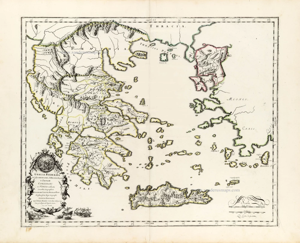
Graecia foederata sub Agamemnone, ob Helenae raptum in Troiam Coniurans ex Homero collecta. 1665
Ancient Greece by Guillaume Sanson.
[Item number: 30039]
Graeciae Universae Secundum Hodiernum Situm Neoterica Descriptio. 1601
Greece by Abraham Ortelius
[Item number: 30623]

Athene vel Minerva XXVII 1493
Fantasy view of Athens, by Hartmann Schedel.
[Item number: 30953]

La Moree et les Isles de Zante, Cefalonie, Ste Maure, Cerigo &c. 1692
Greece - Peloponnese by N. Sanson, so-called published by Hubert Jaillot. (Pirated edition by Pierre Mortier).
[Item number: 31197]
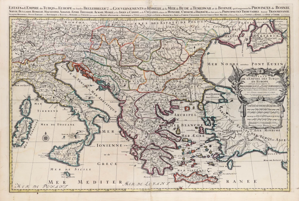
Estats de l'Empire des Turqs en Europe. 1692
European Ottoman Empire by N. Sanson, so-called published by Hubert Jaillot. (Pirated edition by Pierre Mortier).
[Item number: 31199]

Graecia. 1640
Greece, by Joan Blaeu.
[Item number: 31626]

Graecia. 1618
Graecia by Petrus Bertius, published by Jodocus Hondius II.
[Item number: 31852]

Turcicum Imperium. 1618
Ottoman Empire, by Petrus Bertius
[Item number: 32176]

La Grecia divisa nelle sue Provincie. 1779-1785
Greece & Albania, by Antonio Zatta.
[Item number: 32307]

La Grecia Universale Antica Paragonata con la Moderna da Giacomo Cantelli da Vignola 1687
Ancient Greece, by Giacomo Cantelli da Vignola, and published by Giovanni de Rossi.
[Item number: 32956]