
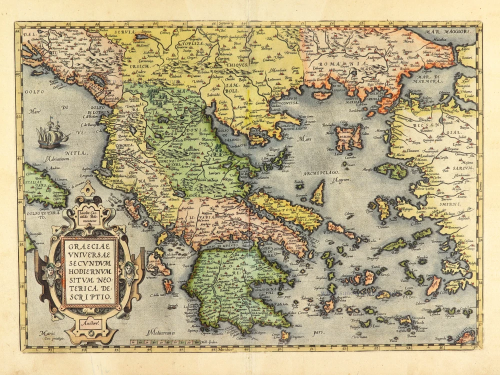
Ptolemy map of Greece by Lorenz Fries, after Martin Waldseemüller. 1525

Lorenz Fries* (c. 1485 – 1532)
Lorenz Fries, a physician, astrologer, and cartographic editor, was a native Alsatian. Nothing is known about his youth and early schooling. His university education in philosophy and medicine has been acquired at several schools. He probably attended Vienna, Montpellier, Piacenza, and Pavia. He obtained a Doctor of Arts degree at one of these institutions.
His first professional position was in Sélestat, near Strasbourg. He practised medicine in Colmar from 1514 to 1518. He wrote several medical works, including a practice entitled Spiegel der Artzny (Mirror of Medicine), a trendy book with seven editions up to 1546. After 1519, he moved to Strasbourg, where he stayed until about 1527.
In 1520, Fries became involved in publishing new editions of maps by Martin Waldseemüller. He collaborated with Peter Apian to publish a much-reduced version of Waldseemüller's map of 1507.
In the meantime, Fries was preparing a new edition of Ptolemy's Geographia. The book was printed in 1522 by Johannes Grüninger, an esteemed printer from Strasbourg who had previously published the Waldseemüller. It was based on Waldseemüller's editions of 1513 and 1520. Fries says in a note to the reader: "…, we declare that Martin Waldseemüller, piously deceased, originally constructed these maps and that they have been drawn in a format smaller than they ever had". The book sold well, and new editions would follow, printed with the same woodblocks.
In 1525, Willibald Pirkheimer, the Nuremberg humanist, published a new edition with Grüninger. The volume was published jointly with the Nuremberg printer Johannes Koberger. It included the same fifty Waldseemüller/Fries maps as the 1522 edition.
Michael Servetus (= Michael Villanovus) printed two more editions in Lyon in 1535 and 1541. Servetus was tried for heresy in 1553. One of the allegations was that he had written a statement on the verso of the map of the Holy Land describing it as primarily infertile. The idea originated in Fries's edition in 1522. Servetus was burned at the stake, and at Calvin's orders, many copies of Servetus's books followed him into the flames.
Fries also published other books on astrology and medicine. In addition, he undertook a reduction of Waldseemüller's large map of 1516, the Carta Marina Navigatoria, which he translated into German simultaneously. The map was published in 1525, but no copy of this edition survived. The earliest copy known is dated 1530.
In 1525, Strasbourg had become a thoroughly reformed city, and the Roman church's adherents found themselves increasingly unwelcome. For this reason, Fries probably renounced his citizenship and moved to Metz. During this period, he published his last two medical works.
*He should be distinct from the historian Lorenz Fries of Mergentheim (1491-1550).
Martin Waldseemüller (Ilacomilus) (c. 1473-1519)
Martin Walseemüller and his collaborator, Matthias Ringmann, are credited with the first recorded usage of the word America to name the New World in honour of the Italian explorer Amerigo Vespucci.
He was born about 1475, most probably in the village of Wolfenweiler near Freiburg in Breisgau (southern Germany). He studied at the University of Freiburg, where he met Johann Scott, the future printer of Waldseemüller’s edition of Ptolemy and Matthias Ringman, a poet who wrote Waldseemüller’s texts. Gregor Reisch was their tutor. He was noted for his philosophical work, Margaretha Philosophica (1503), a widely read book that included a world map in Ptolemaic form. He undoubtedly aroused the students’ interest in cosmography.
At the beginning of the 16th century, Walseemüller moved to St.Dié in the Vosges. He Hellenized his name to Ilacomilus and worked on an edition of Ptolemy. He learned the printing trade in Basle and became a professor of cosmography under the patronage of René II, Duke of Lorraine.
Together with a group of scholars, among them were Nicholas Lud and Matthias Ringmann, they installed a printing press in St. Dié. The first book appeared in 1507: Cosmographiae Introductio… Few books have generated as much interest and speculation as this book because it suggested that the new continent is named America in honour of Amerigo Vespucci, whose letters about his American “discoveries” form a large part of the book. Great interest was also attached to the two maps on the title page constituting part of the Cosmographiae Introductio: a large 12-panel wall map of the world and a set of globe gores. The map and globe were notable for showing the New World as a continent separate from Asia and naming the southern landmass America.
Ringmann wrote the Cosmographiae Introductio's text, using the name ‘America’. He died in 1511, and by then, Waldseemüller was having doubts about the name they had coined.
In 1511, Walseemüller published the Carta Itineraria Europae, a road map of Europe that showed essential trade routes and pilgrim routes from central Europe to Santiago de Compostela, Spain. It was the first printed wall map of Europe.
After Ringmann’s death, Waldseemüller concentrated on the new version of Ptolemy’s Geographia. Johannes Scott finally printed the new edition in 1513 in Strasbourg, and it is now regarded as the most important. Waldseemüller included twenty modern maps in the new Geographia as a separate appendix.
The 1507 wall map was lost for a long time, but Joseph Fischer found a copy in Schloss Wolfegg in southern Germany in 1901. It is the only known copy purchased by the United States Library of Congress in May 2003.
Claudius Ptolemy (c.100 – c.170 AD)
Tabula .X. Europae. [Title on verso]
Item Number: 28196 Authenticity Guarantee
Category: Antique maps > Europe > Greece & Greek Islands
Old, antique map of Greece, by Lorenz Fries.
Title on verso: Tabula .X. Europae.
Cartographer: Martin Waldseemüller.
Date of the first edition: 1522.
Date of this map: 1525.
Woodcut, printed on paper.
Image size: 335 x 450mm (13¼ x 17¾ inches).
Sheet size: 390 x 510mm (15¼ x 20 inches).
Verso: Latin text.
Condition: Centrefold reinforced.
Condition Rating: A.
References: Karrow, 28/11; Zacharakis, 2793/1826
From: L. Fries, Opus Geographiae. Strasbourg, J. Grüninger, 1525. (Karrow, 28/G.1; Shirley (Brit. Lib.), T.PTOL.7b))
Second edition (of four) of this map, based on Waldseemüller's map of Greece.
On the reverse, the text is contained within elaborate Renaissance woodcut panels, which may have been designed by Albrecht Dürer, the known contributor to diagrams elsewhere in the atlas.
Lorenz Fries* (c. 1485 – 1532)
Lorenz Fries, a physician, astrologer, and cartographic editor, was a native Alsatian. Nothing is known about his youth and early schooling. His university education in philosophy and medicine has been acquired at several schools. He probably attended Vienna, Montpellier, Piacenza, and Pavia. He obtained a Doctor of Arts degree at one of these institutions.
His first professional position was in Sélestat, near Strasbourg. He practised medicine in Colmar from 1514 to 1518. He wrote several medical works, including a practice entitled Spiegel der Artzny (Mirror of Medicine), a trendy book with seven editions up to 1546. After 1519, he moved to Strasbourg, where he stayed until about 1527.
In 1520, Fries became involved in publishing new editions of maps by Martin Waldseemüller. He collaborated with Peter Apian to publish a much-reduced version of Waldseemüller's map of 1507.
In the meantime, Fries was preparing a new edition of Ptolemy's Geographia. The book was printed in 1522 by Johannes Grüninger, an esteemed printer from Strasbourg who had previously published the Waldseemüller. It was based on Waldseemüller's editions of 1513 and 1520. Fries says in a note to the reader: "…, we declare that Martin Waldseemüller, piously deceased, originally constructed these maps and that they have been drawn in a format smaller than they ever had". The book sold well, and new editions would follow, printed with the same woodblocks.
In 1525, Willibald Pirkheimer, the Nuremberg humanist, published a new edition with Grüninger. The volume was published jointly with the Nuremberg printer Johannes Koberger. It included the same fifty Waldseemüller/Fries maps as the 1522 edition.
Michael Servetus (= Michael Villanovus) printed two more editions in Lyon in 1535 and 1541. Servetus was tried for heresy in 1553. One of the allegations was that he had written a statement on the verso of the map of the Holy Land describing it as primarily infertile. The idea originated in Fries's edition in 1522. Servetus was burned at the stake, and at Calvin's orders, many copies of Servetus's books followed him into the flames.
Fries also published other books on astrology and medicine. In addition, he undertook a reduction of Waldseemüller's large map of 1516, the Carta Marina Navigatoria, which he translated into German simultaneously. The map was published in 1525, but no copy of this edition survived. The earliest copy known is dated 1530.
In 1525, Strasbourg had become a thoroughly reformed city, and the Roman church's adherents found themselves increasingly unwelcome. For this reason, Fries probably renounced his citizenship and moved to Metz. During this period, he published his last two medical works.
*He should be distinct from the historian Lorenz Fries of Mergentheim (1491-1550).
Martin Waldseemüller (Ilacomilus) (c. 1473-1519)
Martin Walseemüller and his collaborator, Matthias Ringmann, are credited with the first recorded usage of the word America to name the New World in honour of the Italian explorer Amerigo Vespucci.
He was born about 1475, most probably in the village of Wolfenweiler near Freiburg in Breisgau (southern Germany). He studied at the University of Freiburg, where he met Johann Scott, the future printer of Waldseemüller’s edition of Ptolemy and Matthias Ringman, a poet who wrote Waldseemüller’s texts. Gregor Reisch was their tutor. He was noted for his philosophical work, Margaretha Philosophica (1503), a widely read book that included a world map in Ptolemaic form. He undoubtedly aroused the students’ interest in cosmography.
At the beginning of the 16th century, Walseemüller moved to St.Dié in the Vosges. He Hellenized his name to Ilacomilus and worked on an edition of Ptolemy. He learned the printing trade in Basle and became a professor of cosmography under the patronage of René II, Duke of Lorraine.
Together with a group of scholars, among them were Nicholas Lud and Matthias Ringmann, they installed a printing press in St. Dié. The first book appeared in 1507: Cosmographiae Introductio… Few books have generated as much interest and speculation as this book because it suggested that the new continent is named America in honour of Amerigo Vespucci, whose letters about his American “discoveries” form a large part of the book. Great interest was also attached to the two maps on the title page constituting part of the Cosmographiae Introductio: a large 12-panel wall map of the world and a set of globe gores. The map and globe were notable for showing the New World as a continent separate from Asia and naming the southern landmass America.
Ringmann wrote the Cosmographiae Introductio's text, using the name ‘America’. He died in 1511, and by then, Waldseemüller was having doubts about the name they had coined.
In 1511, Walseemüller published the Carta Itineraria Europae, a road map of Europe that showed essential trade routes and pilgrim routes from central Europe to Santiago de Compostela, Spain. It was the first printed wall map of Europe.
After Ringmann’s death, Waldseemüller concentrated on the new version of Ptolemy’s Geographia. Johannes Scott finally printed the new edition in 1513 in Strasbourg, and it is now regarded as the most important. Waldseemüller included twenty modern maps in the new Geographia as a separate appendix.
The 1507 wall map was lost for a long time, but Joseph Fischer found a copy in Schloss Wolfegg in southern Germany in 1901. It is the only known copy purchased by the United States Library of Congress in May 2003.
Claudius Ptolemy (c.100 – c.170 AD)
Related items

Parergon map
Graecia, Sophiani. 1624
Greece, by Ortelius A.
[Item number: 2050]

Tabula Europae X 1542
Greece, by Sebastian Münster.
[Item number: 14704]

Nova Totius Graeciae descriptio. 1638
Greece, by J. Janssonius.
[Item number: 15357]

Graecia. 1633
Greece, by Gerard Mercator.
[Item number: 16999]

Graeciae Universae Secundum Hodiernum Situm Neoterica Descriptio. Jacobo Castaldo Pedemontano Autore. 1608
Greece, by Matthias Quad.
[Item number: 18856]

Graeciae Universae Secundum Hodiernum Situm Neoterica Descriptio. 1592
Greece by Abraham Ortelius.
[Item number: 22970]

Graecia Sophiani / Ex conatibus geographicis Abrahami Ortelii Antuerpiensis Ao. 1596 / Judocus Hondius excudit. 1618
Greece, by Bertius P. - Hondius J.
[Item number: 24541]

La nouvelle Grece selon toutes les regions & provinces d'icelle tant deca que de la l'Hellespont. 1555
Greece, by S. Munster.
[Item number: 25168]

Carte de la Grece. 1725-50
Greece by Reinier & Josua Ottens
[Item number: 27699]

Graeciae Antiquae 1776-79
Ancient Greece, by Paolo Santini, after Jean-Baptiste Bourguignon d'Anville.
[Item number: 28108]

Ta Moder Bossinae, Serviae, Graeciae, et Sclavoniae. [From verso] 1525
Greece (Balkan), by Lorenz Fries after Martin Waldseemüller.
[Item number: 28117]

Graecia. 1658
Greece by Nicolas Sanson.
[Item number: 28498]

Graeciae Antique Tabula Geographica; 1699-1710
Greece by Nicolas & Guillaume Sanson.
[Item number: 28575]

Carte Historique et Géographique de l'ancienne Grèce, avec les remarques Cursieuses pour l'intelligence de l'Histoire. 1713
Greece by Zacharias Châtelain.
[Item number: 29553]

Graecia - Graeciae Antiquae Tabulam. 1652
Ancient Greece by Nicolas Sanson.
[Item number: 29693]

Arcipelago - [Above map :] Descrittione dell'Arcipelago. 1590
Greece by Thomaso Porcacchi.
[Item number: 29769]
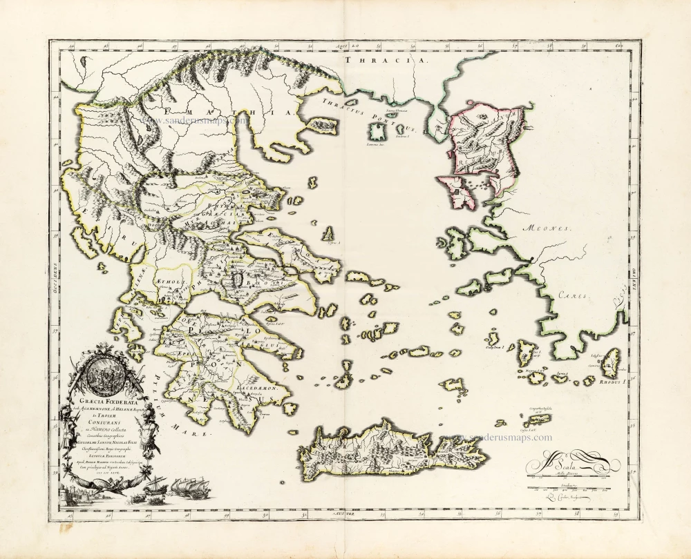
Graecia foederata sub Agamemnone, ob Helenae raptum in Troiam Coniurans ex Homero collecta. 1665
Ancient Greece by Guillaume Sanson.
[Item number: 30039]
Graeciae Universae Secundum Hodiernum Situm Neoterica Descriptio. 1601
Greece by Abraham Ortelius
[Item number: 30623]

Athene vel Minerva XXVII 1493
Fantasy view of Athens, by Hartmann Schedel.
[Item number: 30953]

La Moree et les Isles de Zante, Cefalonie, Ste Maure, Cerigo &c. 1692
Greece - Peloponnese by N. Sanson, so-called published by Hubert Jaillot. (Pirated edition by Pierre Mortier).
[Item number: 31197]
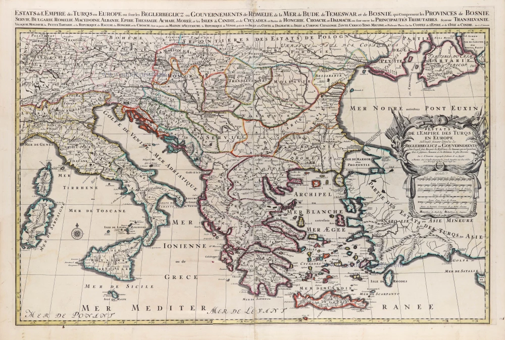
Estats de l'Empire des Turqs en Europe. 1692
European Ottoman Empire by N. Sanson, so-called published by Hubert Jaillot. (Pirated edition by Pierre Mortier).
[Item number: 31199]

Graecia. 1640
Greece, by Joan Blaeu.
[Item number: 31626]

Graecia. 1618
Graecia by Petrus Bertius, published by Jodocus Hondius II.
[Item number: 31852]

Turcicum Imperium. 1618
Ottoman Empire, by Petrus Bertius
[Item number: 32176]

La Grecia divisa nelle sue Provincie. 1779-1785
Greece & Albania, by Antonio Zatta.
[Item number: 32307]

La Grecia Universale Antica Paragonata con la Moderna da Giacomo Cantelli da Vignola 1687
Ancient Greece, by Giacomo Cantelli da Vignola, and published by Giovanni de Rossi.
[Item number: 32956]