
First State - First Edition.
Roma by Georg Braun & Frans Hogenberg. (Rome) 1588
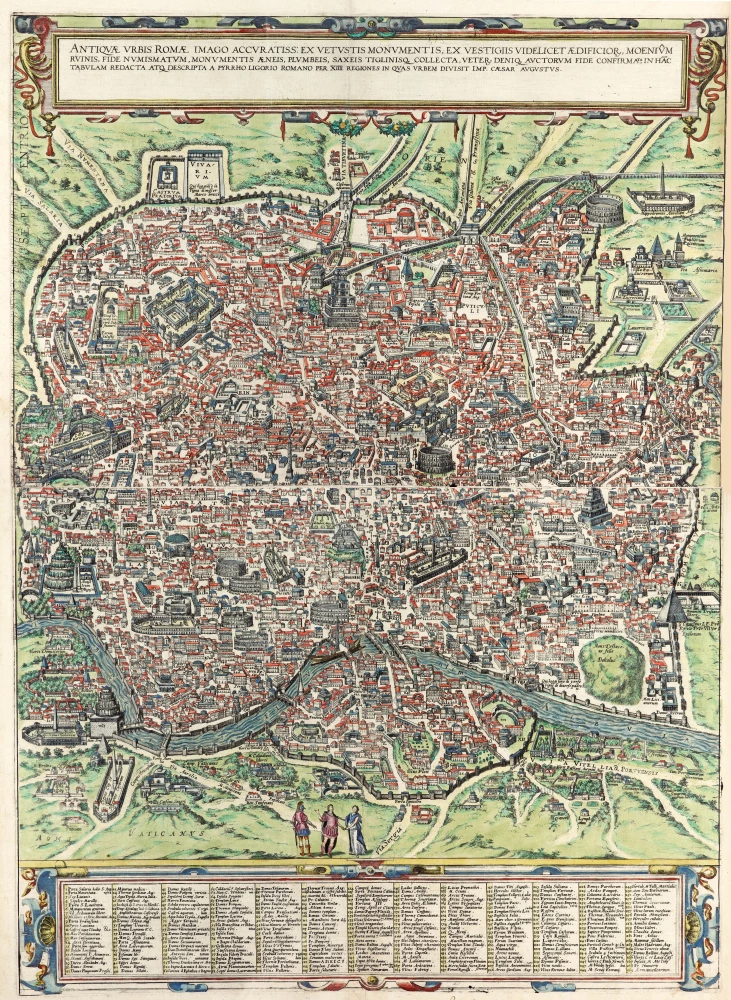
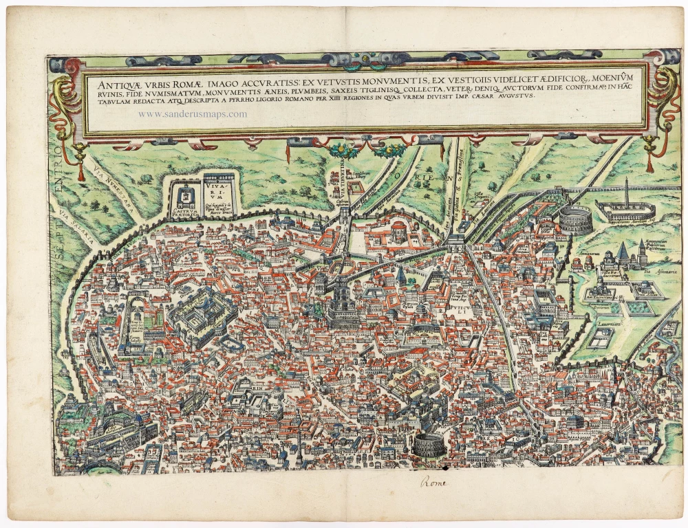
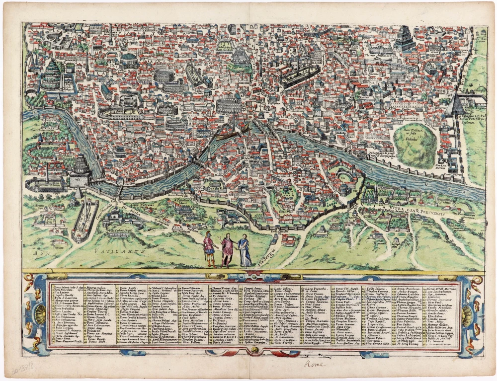


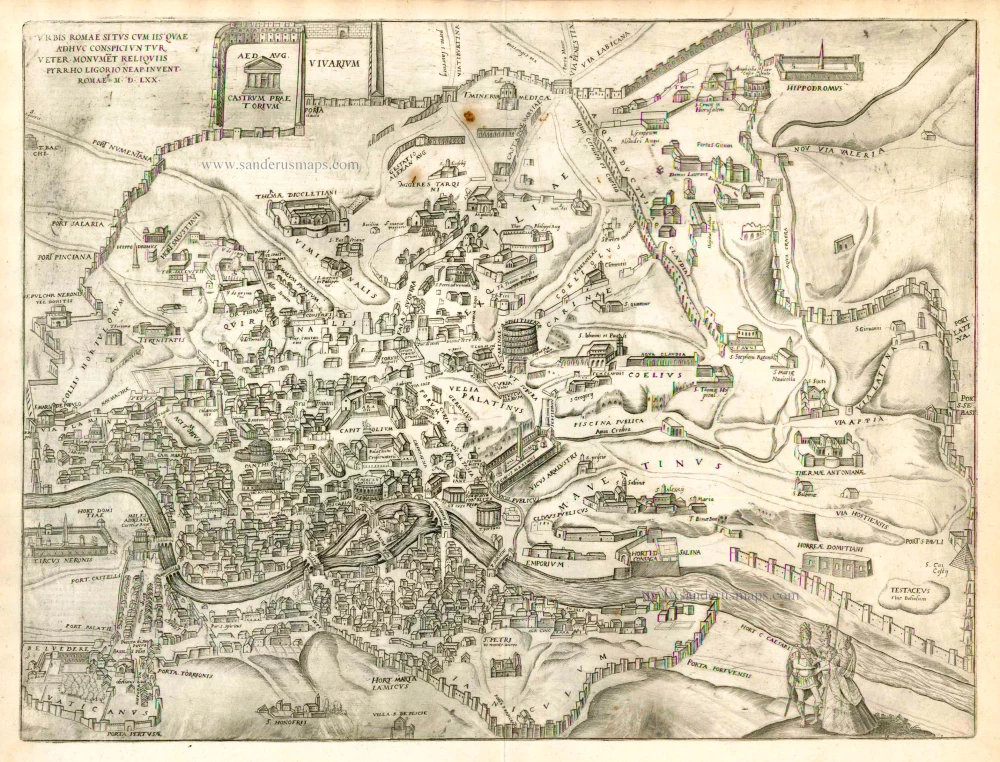
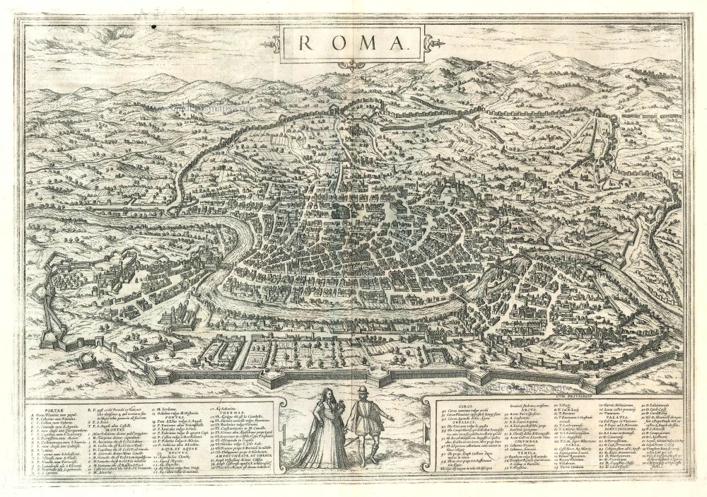
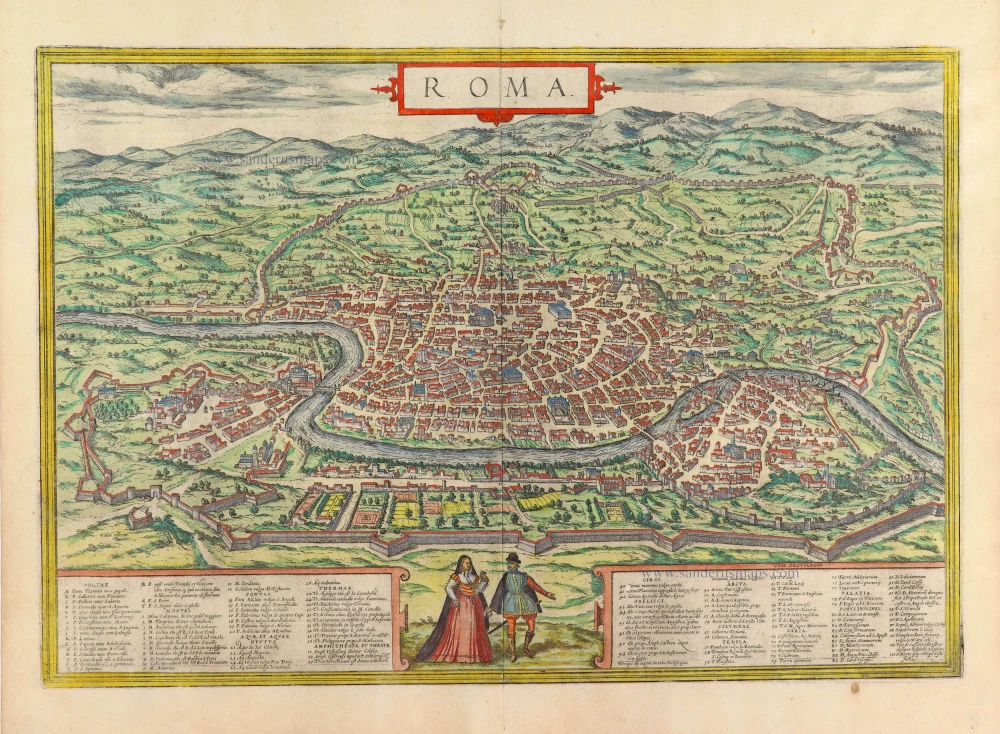
TRANSLATION OF CARTOUCHE TEXT: An accurate picture of ancient Rome: compiled from ancient monuments, traces of buildings, remains of the city walls, the testimony of coins, bronze, lead, stone and terracotta artefacts and reconstructed in this illustration and described by the Roman Pyrrhus Ligorius with all 14 regions into which the Emperor Caesar Augustus divided the city: Rome, the Queen of Cities, was, as tradition has it, founded by the Alban League (Alba Long) led by the youths Romulus and Remus, who were Numitor's grandsons, and named Rome after Romulus. Initially, the city was confined to a square shape. Surrounded in the era of the kings and consuls by fortifications with three, or, according to Pliny, four gates, of varying thickness and appearance, it was given many gates when the wall encircling it was enlarged. The city encompassed seven hills and was divided into 14 regions, but the valleys and the level plains were filled with domed buildings that made them so like the hills that some of the hills could scarcely be distinguished from them. In the imperial era, the city was adorned with stately buildings, which destroyed the upheavals of the period of barbarian incursions. Nevertheless, the present plate shows everything with great accuracy so that the viewer, if so inclined, can enjoy it with little effort.
COMMENTARY BY BRAUN: "I believe, gentle reader, that the mind of almost no man is capable of imagining the appearance of the city of Rome in its entirety or explaining it if he wishes to do justice to its beauty and political system before it was devastated and ravaged by foreign peoples. That is so, especially since describing a city like this does not seem a lesser or easier undertaking than if someone should take it upon himself to illustrate or describe the entire world. [...] In our time, the city of Rome is still so superior to others that all peoples and nations of the Holy Roman Church are more than willing to submit themselves to its authority, not through force of arms as in the old days, but through the power of religion. Religion makes men peaceable and even the savage and outlandish nations, as monstrous as they may be, more benevolent and mild. By contrast, differences in language and religion separate men from one another and alienate them from each other. That is why the dumb beasts of the field, not being endowed with reason, can keep company with one another more easily than men can. For if all men in the world were to worship and venerate a divine being in the same way, not much superstition and strife would emerge among them. Thus, the city of Rome still retains a shadow of her old majesty, especially as all the world's peoples are coordinated and aligned with her, much like the limbs of a body are to its head."
The city is seen from the west in a conjectural bird's-eye view that was a major achievement in its day. It includes the most important ancient buildings, several aqueducts, the Aurelian Wall and large arterial streets. The three figures in Roman garb in the foreground underscore the aim of meticulous reconstruction. The first feature to strike the eye is Mont Testaccio on the far side of the Tiber in the lower right-hand edge of the picture, with the Pyramid of Cestius above it to the right. At the centre of the illustration, the Marcellus Theatre can be identified above the island in the Tiber, with the vast Circus Maximus used for chariot races just above it to the right. Above that is the Palatine, represented by intricately detailed buildings, indicating the confusion at the time about how the seat of imperial power looked. To the north, the Coliseum flanks the Palatine. In the lower left-hand part of the picture field is the Campus Martius, with the stadium of Domitian at the centre. The Piazza Navona now occupies the site. Slightly higher up is the Pantheon with its monumental dome, looking as it does today. On the lower left edge, the two great imperial mausoleums have been imaginatively reconstructed: above the mausoleum of Augustus and below, at the bend in the river, that of Hadrian. In the lower left-hand corner, the Mons Vaticanus, the Circus built by Caligula, and a Neronian palace are recognisable outside the city. The baths of Diocletian dominate the northeastern part of the city. The Castra Praetoria, the barracks of the Praetorian Guard, is shown below the city walls in the upper left-hand corner. (Taschen)
Braun G. & Hogenberg F. and the Civitates Orbis Terrarum.
The Civitates Orbis Terrarum, also known as the 'Braun & Hogenberg', is a six-volume town atlas and the most excellent book of town views and plans ever published: 363 engravings, sometimes beautifully coloured. It was one of the best-selling works in the last quarter of the 16th century. Georg Braun, a skilled writer, wrote the text accompanying the plans and views on the verso. Many plates were engraved after the original drawings of a professional artist, Joris Hoefnagel (1542-1600). The first volume was published in Latin in 1572 and the sixth in 1617. Frans Hogenberg, a talented engraver, created the tables for volumes I through IV, and Simon van den Neuwel made those for volumes V and VI. Other contributors were cartographers Daniel Freese and Heinrich Rantzau, who provided valuable geographical information. Works by Jacob van Deventer, Sebastian Münster, and Johannes Stumpf were also used as references. Translations appeared in German and French, making the atlas accessible to a broader audience.
Since its original publication of volume 1 in 1572, the Civitates Orbis Terrarum has left an indelible mark on the history of cartography. Seven more editions followed the first volume in 1575, 1577, 1582, 1588, 1593, 1599, and 1612. Vol.2, initially released in 1575, saw subsequent editions in 1597 and 1612. The subsequent volumes, each a treasure trove of historical insights, graced the world in 1581, 1588, 1593, 1599, and 1606. The German translation of the first volume, a testament to its widespread appeal, debuted in 1574, followed by the French edition in 1575.
Several printers were involved: Theodor Graminaeus, Heinrich von Aich, Gottfried von Kempen, Johannis Sinniger, Bertram Buchholtz, and Peter von Brachel, all of whom worked in Cologne.
Georg Braun (1541-1622)
Georg Braun, the author of the text accompanying the plans and views in the Civitates Orbis Terrarum, was born in Cologne in 1541. After his studies in Cologne, he entered the Jesuit Order as a novice, indicating his commitment to learning and intellectual pursuits. In 1561, he obtained his bachelor's degree; in 1562, he received his Magister Artium, further demonstrating his academic achievements. Although he left the Jesuit Order, he continued his studies in theology, gaining a licentiate in theology. His theological background likely influenced the content and tone of the text in the Civitates Orbis Terrarum, adding a unique perspective to the work.
Frans Hogenberg (1535-1590)
Frans Hogenberg was a Flemish and German painter, engraver, and mapmaker. He was born in Mechelen as the son of Nicolaas Hogenberg.
By the end of the 1560s, Frans Hogenberg was employed upon Abraham Ortelius's Theatrum Orbis Terrarum, published in 1570; he is named an engraver of numerous maps. In 1568, he was banned from Antwerp by the Duke of Alva and travelled to London, where he stayed a few years before emigrating to Cologne. He immediately embarked on his two most important works, the Civitates, published in 1572 and the Geschichtsblätter, which appeared in several series from 1569 until about 1587.
Thanks to large-scale projects like the Geschichtsblätter and the Civitates, Hogenberg's social circumstances improved with each passing year. He died as a wealthy man in Cologne in 1590.
Antiquae Urbis Romae imago accuratiss: ex vetustis monumentis, ex vestigiis videlicet aedificior, moenium, ruinis, fide numismatum, monumentis aeneis, plumbeis, saxeis tiglinisq collecta, veter. deniq. auctorum fide confirmata,
Item Number: 30137 Authenticity Guarantee
Category: Antique maps > Europe > Italy - Cities
Ancient Rome (Roma), by Georg Braun & Frans Hogenberg.
Title: Antiquae Urbis Romae imago accuratiss: ex vetustis monumentis, ex vestigiis videlicet aedificior, moenium, ruinis, fide numismatum, monumentis aeneis, plumbeis, saxeis tiglinisq collecta, veter. deniq. auctorum fide confirmata,
in hac tabulam redacta atq. descripta a Pyrrho Ligorio Romano per XIIII Regiones in quas Urbem divisit Imp. Caesar Augustus.
With a key to 269 locations.
Oriented to the northeast.
Cartographer: Pirro Ligorio.
Date of the first edition: 1588.
Date of this map: 1588.
Copper engraving, printed from two plates on two sheets of paper, unjoined..
Image size when joined: 685 x 500mm (26.97 x 19.69 inches).
Sheet size each: 400 x 530mm (15.75 x 20.87 inches).
Verso: Latin text.
Condition: Original coloured, upper part with short right margin.
Condition Rating: A+.
From: Liber Quartus Urbium Praecipuarum Totius Mundi. Cologne, 1588. (Koeman, B&H4, Van der Krogt 4, 41:1.4)
TRANSLATION OF CARTOUCHE TEXT: An accurate picture of ancient Rome: compiled from ancient monuments, traces of buildings, remains of the city walls, the testimony of coins, bronze, lead, stone and terracotta artefacts and reconstructed in this illustration and described by the Roman Pyrrhus Ligorius with all 14 regions into which the Emperor Caesar Augustus divided the city: Rome, the Queen of Cities, was, as tradition has it, founded by the Alban League (Alba Long) led by the youths Romulus and Remus, who were Numitor's grandsons, and named Rome after Romulus. Initially, the city was confined to a square shape. Surrounded in the era of the kings and consuls by fortifications with three, or, according to Pliny, four gates, of varying thickness and appearance, it was given many gates when the wall encircling it was enlarged. The city encompassed seven hills and was divided into 14 regions, but the valleys and the level plains were filled with domed buildings that made them so like the hills that some of the hills could scarcely be distinguished from them. In the imperial era, the city was adorned with stately buildings, which destroyed the upheavals of the period of barbarian incursions. Nevertheless, the present plate shows everything with great accuracy so that the viewer, if so inclined, can enjoy it with little effort.
COMMENTARY BY BRAUN: "I believe, gentle reader, that the mind of almost no man is capable of imagining the appearance of the city of Rome in its entirety or explaining it if he wishes to do justice to its beauty and political system before it was devastated and ravaged by foreign peoples. That is so, especially since describing a city like this does not seem a lesser or easier undertaking than if someone should take it upon himself to illustrate or describe the entire world. [...] In our time, the city of Rome is still so superior to others that all peoples and nations of the Holy Roman Church are more than willing to submit themselves to its authority, not through force of arms as in the old days, but through the power of religion. Religion makes men peaceable and even the savage and outlandish nations, as monstrous as they may be, more benevolent and mild. By contrast, differences in language and religion separate men from one another and alienate them from each other. That is why the dumb beasts of the field, not being endowed with reason, can keep company with one another more easily than men can. For if all men in the world were to worship and venerate a divine being in the same way, not much superstition and strife would emerge among them. Thus, the city of Rome still retains a shadow of her old majesty, especially as all the world's peoples are coordinated and aligned with her, much like the limbs of a body are to its head."
The city is seen from the west in a conjectural bird's-eye view that was a major achievement in its day. It includes the most important ancient buildings, several aqueducts, the Aurelian Wall and large arterial streets. The three figures in Roman garb in the foreground underscore the aim of meticulous reconstruction. The first feature to strike the eye is Mont Testaccio on the far side of the Tiber in the lower right-hand edge of the picture, with the Pyramid of Cestius above it to the right. At the centre of the illustration, the Marcellus Theatre can be identified above the island in the Tiber, with the vast Circus Maximus used for chariot races just above it to the right. Above that is the Palatine, represented by intricately detailed buildings, indicating the confusion at the time about how the seat of imperial power looked. To the north, the Coliseum flanks the Palatine. In the lower left-hand part of the picture field is the Campus Martius, with the stadium of Domitian at the centre. The Piazza Navona now occupies the site. Slightly higher up is the Pantheon with its monumental dome, looking as it does today. On the lower left edge, the two great imperial mausoleums have been imaginatively reconstructed: above the mausoleum of Augustus and below, at the bend in the river, that of Hadrian. In the lower left-hand corner, the Mons Vaticanus, the Circus built by Caligula, and a Neronian palace are recognisable outside the city. The baths of Diocletian dominate the northeastern part of the city. The Castra Praetoria, the barracks of the Praetorian Guard, is shown below the city walls in the upper left-hand corner. (Taschen)
Braun G. & Hogenberg F. and the Civitates Orbis Terrarum.
The Civitates Orbis Terrarum, also known as the 'Braun & Hogenberg', is a six-volume town atlas and the most excellent book of town views and plans ever published: 363 engravings, sometimes beautifully coloured. It was one of the best-selling works in the last quarter of the 16th century. Georg Braun, a skilled writer, wrote the text accompanying the plans and views on the verso. Many plates were engraved after the original drawings of a professional artist, Joris Hoefnagel (1542-1600). The first volume was published in Latin in 1572 and the sixth in 1617. Frans Hogenberg, a talented engraver, created the tables for volumes I through IV, and Simon van den Neuwel made those for volumes V and VI. Other contributors were cartographers Daniel Freese and Heinrich Rantzau, who provided valuable geographical information. Works by Jacob van Deventer, Sebastian Münster, and Johannes Stumpf were also used as references. Translations appeared in German and French, making the atlas accessible to a broader audience.
Since its original publication of volume 1 in 1572, the Civitates Orbis Terrarum has left an indelible mark on the history of cartography. Seven more editions followed the first volume in 1575, 1577, 1582, 1588, 1593, 1599, and 1612. Vol.2, initially released in 1575, saw subsequent editions in 1597 and 1612. The subsequent volumes, each a treasure trove of historical insights, graced the world in 1581, 1588, 1593, 1599, and 1606. The German translation of the first volume, a testament to its widespread appeal, debuted in 1574, followed by the French edition in 1575.
Several printers were involved: Theodor Graminaeus, Heinrich von Aich, Gottfried von Kempen, Johannis Sinniger, Bertram Buchholtz, and Peter von Brachel, all of whom worked in Cologne.
Georg Braun (1541-1622)
Georg Braun, the author of the text accompanying the plans and views in the Civitates Orbis Terrarum, was born in Cologne in 1541. After his studies in Cologne, he entered the Jesuit Order as a novice, indicating his commitment to learning and intellectual pursuits. In 1561, he obtained his bachelor's degree; in 1562, he received his Magister Artium, further demonstrating his academic achievements. Although he left the Jesuit Order, he continued his studies in theology, gaining a licentiate in theology. His theological background likely influenced the content and tone of the text in the Civitates Orbis Terrarum, adding a unique perspective to the work.
Frans Hogenberg (1535-1590)
Frans Hogenberg was a Flemish and German painter, engraver, and mapmaker. He was born in Mechelen as the son of Nicolaas Hogenberg.
By the end of the 1560s, Frans Hogenberg was employed upon Abraham Ortelius's Theatrum Orbis Terrarum, published in 1570; he is named an engraver of numerous maps. In 1568, he was banned from Antwerp by the Duke of Alva and travelled to London, where he stayed a few years before emigrating to Cologne. He immediately embarked on his two most important works, the Civitates, published in 1572 and the Geschichtsblätter, which appeared in several series from 1569 until about 1587.
Thanks to large-scale projects like the Geschichtsblätter and the Civitates, Hogenberg's social circumstances improved with each passing year. He died as a wealthy man in Cologne in 1590.
Related items
Roma - Rom. ca. 1750
Rome by Johan Christian Haffner
[Item number: 734]
Urbis Romae Veteris ac Modernae Accurata Delineatio ... 1716-37
Rome (Roma), by J.B. Homann.
[Item number: 1856]
Urbis Romae Situs cum ils quae adhuc Conspiciuntur Veter. Monumet Reliquiis Pyrrho Ligorio Neap. Invent. Romae M.D.LXX 1623
Ancient Rome by Braun and Hogenberg.
[Item number: 22409]
Roma. 1599
Rome by Braun and Hogenberg.
[Item number: 23941]
Roma. 1658/60
Rome (Roma), by P.H. Schut.
[Item number: 26626]

Roma. 1704
Rome by Pieter Mortier
[Item number: 27849]
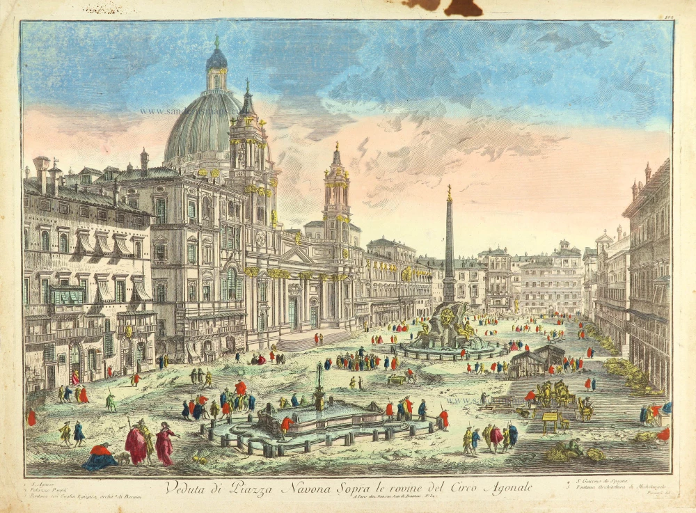
Veduta di Piazza Navona Sopra le rovine del Circo Agonale. c. 1780
Rome (Roma), Piazza Navona after Piranesi, published in Paris by the Jean family.
[Item number: 28893]
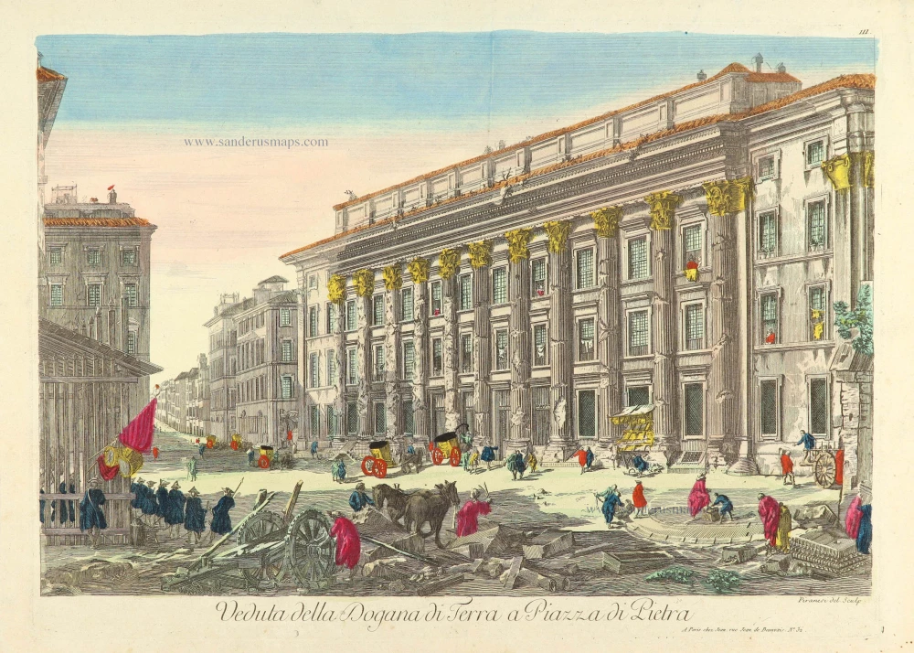
Veduta della Dogana di Terra a Piazza di Pietra. c. 1780
Rome (Roma), Piazza di Pietra, after Piranesi, published in Paris by the Jean family.
[Item number: 28903]

Larii Lacus vulgo Comensis descriptio - Territorii Romani descrip. - Fori Iulii, vulgo Friuli Typus. 1601
Como - Rome - Friuli by Abraham Ortelius
[Item number: 28930]
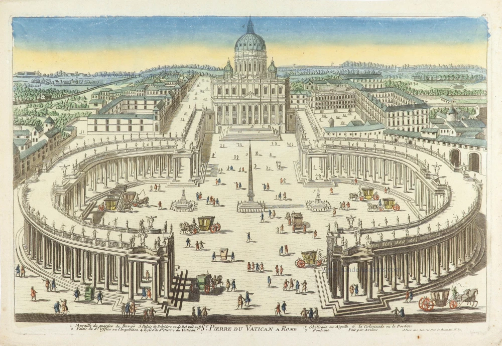
St. Pierre du Vatican A Rome. c. 1780
St. Peter Vatican by Aveline (Rome), published in Paris by the Jean family
[Item number: 28941]
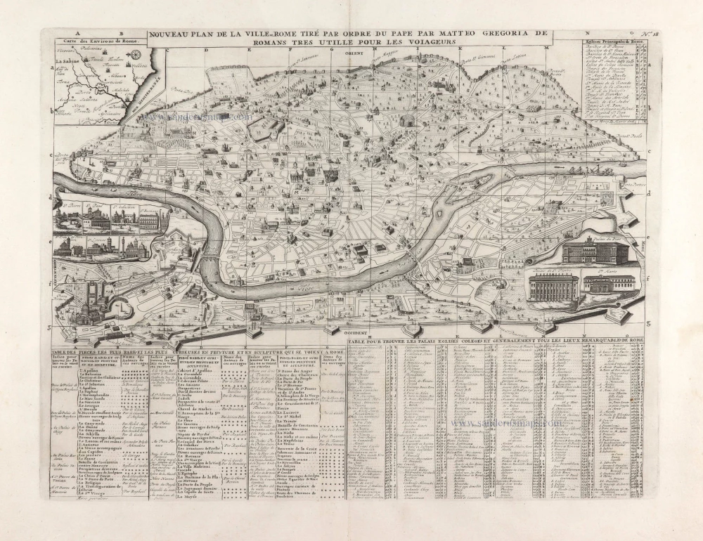
Nouveau Pland de la Ville de Rome tiré par ordre du Pape par Matteo Gregoria de Romans tres utille pour les voiageurs. 1713
Bird's eye view plan of Rome by Zacharias Châtelain.
[Item number: 29640]
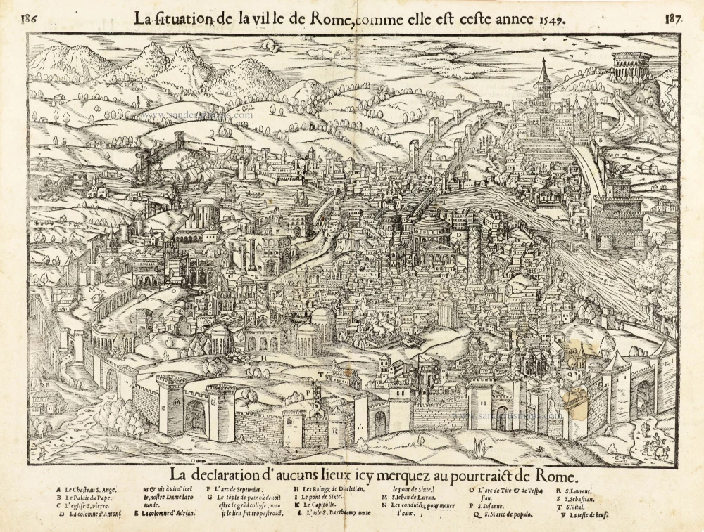
La situation de la ville de Rome, comme elle est ceste annee 1549. 1568
Rome, by Sebastian Münster.
[Item number: 30595]
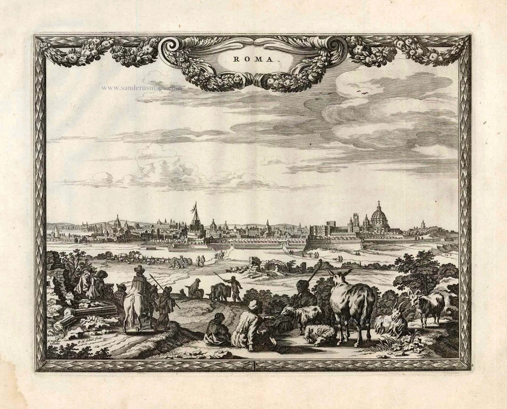
Roma. c. 1610
Rome by Georg Braun & Frans Hogenberg
[Item number: 30631]