
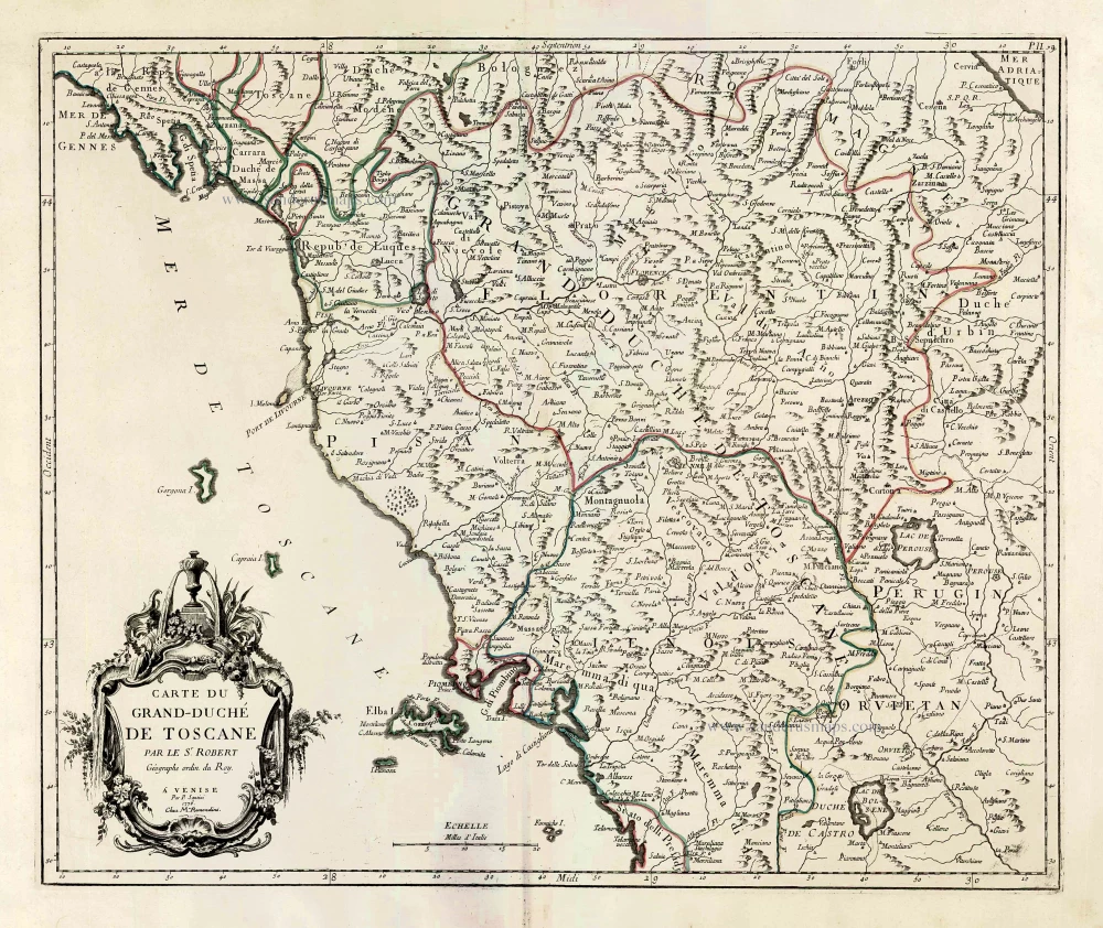
Tuscany (Toscana) by Francesco & Paolo Santini 1776-79
Francesco and Paolo Santini (c.1729-1793)
Francesco Santini, a Venetian publisher, acquired the printing plates of Vaugondy’s Atlas Universel …, a commercial and cartographic success, with widespread influence on mapmakers throughout Europe. Together with his brother Paolo, he commissioned a new set of plates and reissued the atlas in 1776. The following year, Paolo Santini assigned all his publication rights to M. Remondini, who in 1777 reissued the same atlas but with his name.
Gilles and Didier Robert de Vaugondy
Gilles Robert de Vaugondy (1688-1766) and his son Didier Robert de Vaugondy (1723-1786) were leading cartographers in France during the 18th century. They served both as geographer to the king of France. The father, Gilles is also known as ‘Le Sieur’ or ‘Monsieur Robert’. He descended from the Nicolas Sanson family through Sanson's grandson Pierre Moulard-Sanson, from whom he inherited Sanson's cartographic material. After Hubert Jaillot died in 1712, the de Vaugondy's acquired numerous copies of his maps and plates, which formed the basis of their beautiful Atlas Universel (1757).
Their business flourished from 1731 to 1778. They made a substantial contribution to the world of cartography.
Carte du Grand-Duché de Toscane.
Item Number: 27724 Authenticity Guarantee
Category: Antique maps > Europe > Italy
Old, antique map of Tuscany (Toscana), by Francesco & Paolo Santini.
<i>Mappa antica della Toscana, di Paolo Santini.</i>
Title: Carte du Grand-Duché de Toscane.
Cartographer: Gilles Robert de Vaugondy.
Date of the first edition: 1776.
Date of this map: 1776-79.
Copper engraving, printed on paper.
Size (not including margins): 470 x 560mm (18.5 x 22.05 inches).
Verso: Blank.
Condition: Original coloured in outline, excellent.
Condition Rating: A+.
From: Atlas Universel dressé sur les meilleures cartes modernes. Venice, Remondini, 1776-79.
Francesco and Paolo Santini (c.1729-1793)
Francesco Santini, a Venetian publisher, acquired the printing plates of Vaugondy’s Atlas Universel …, a commercial and cartographic success, with widespread influence on mapmakers throughout Europe. Together with his brother Paolo, he commissioned a new set of plates and reissued the atlas in 1776. The following year, Paolo Santini assigned all his publication rights to M. Remondini, who in 1777 reissued the same atlas but with his name.
Gilles and Didier Robert de Vaugondy
Gilles Robert de Vaugondy (1688-1766) and his son Didier Robert de Vaugondy (1723-1786) were leading cartographers in France during the 18th century. They served both as geographer to the king of France. The father, Gilles is also known as ‘Le Sieur’ or ‘Monsieur Robert’. He descended from the Nicolas Sanson family through Sanson's grandson Pierre Moulard-Sanson, from whom he inherited Sanson's cartographic material. After Hubert Jaillot died in 1712, the de Vaugondy's acquired numerous copies of his maps and plates, which formed the basis of their beautiful Atlas Universel (1757).
Their business flourished from 1731 to 1778. They made a substantial contribution to the world of cartography.
Related items

Thusciae. 1601
Tuscany (Toscana), by A. Ortelius.
[Item number: 8067]

Stato della Chiesa con la Toscana 1644-58
Papal State - Tuscany (Toscana) by Janssonius J. - Hondius H.
[Item number: 19236]

Status Ecclesiasticus et Magnus Ducatus Thoscanae. c. 1680
Papal States & Toscana by Frederik De Wit.
[Item number: 24382]

Le Grand Duché de Toscane. 1713
Tuscany (Toscana) by P. Van der Aa.
[Item number: 26079]

Parergon map
Tusciae Antiquae Typus. 1595
Ancient Tuscany (Toscana), by Abraham Ortelius.
[Item number: 30672]

Tuscia. c. 1610-1650
Tuscany (Toscana), by Gerard Mercator.
[Item number: 30924]
Tuscia. 1607
Toscana by Gerard Mercator, published by Jodocus Hondius.
[Item number: 31461]

Thuscia. 1618
Toscana by Petrus Bertius, published by Jodocus Hondius II.
[Item number: 31634]

Stato della Chiesa, con la Toscana. 1647
Papal State - Tuscany (Toscana), by Willem Blaeu.
[Item number: 31840]

Scarce
Status Ecclesiasticus et Magnus Ducatus Thoscanae. c. 1696
Tuscany - Papal States by Cornelis Danckerts.
[Item number: 32509]

Rare
Toscana Inferiore, Detta Anticamente Tuscia Suburbicaria. 1675
Toscana (Tuscany) by Joannes Janssonius.
[Item number: 32601]

Descrittione dello Stato della Chiesa e della Toscana 1687
Papal States - Tuscany (Toscana), by Michel Antoine Baudrand, published by Giovanni de Rossi.
[Item number: 32919]
new
Stato della Chiesa. - Dominium Ecclesiasticum in Italia. c. 1633-1650
Papal State & central Italy by Henricus Hondius
[Item number: 33030]
new