
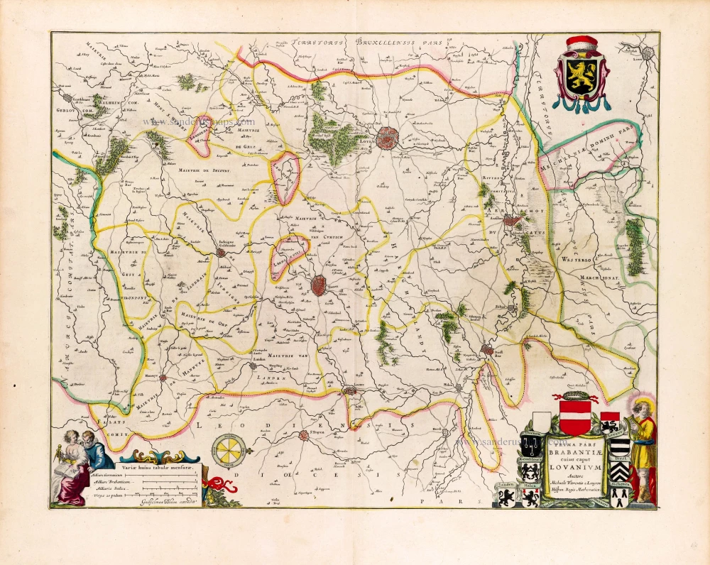
Brabant - Leuven by Willem Blaeu. 1643
The item displayed on this page has been sold. However, we have a similar map in stock:
Leuven by Willem Blaeu. 1635
Prima Pars Brabantiae cuius caput Lovanium.
[Item number: 31046]


The Blaeus: Willem Janszoon, Cornelis & Joan
Willem Jansz. Blaeu and his son Joan Blaeu are the seventeenth century's most widely known cartographic publishers.
Willem Jansz. (also written Guilielmus Janssonius) = Willem Janszoon Blaeu was born in Uitgeest (Netherlands), near Alkmaar, in 1571. He studied mathematics under Tycho Brahe and learned the theory and practice of astronomical observations and the art of instrument- and globe-making.
In 1596, he came to Amsterdam, where he settled down as a globe-, instrument- and map-maker. He published his first cartographic work (a globe) in 1599 and probably published his first printed map (a map of the Netherlands) in 1604. He specialised in maritime cartography, published the first edition of the pilot guide Het Licht der Zeevaert in 1608, and was appointed Hydrographer of the V.O.C. (United East India Company) in 1633. After publishing books, wall maps, globes, charts and pilot guides for thirty years, he brought out his first atlas, Atlas Appendix (1630). This was the beginning of the great tradition of atlas-making by the Blaeus.
In 1618, another mapmaker, bookseller and publisher, Johannes Janssonius, established himself in Amsterdam next door to Blaeu's shop. No wonder these two neighbours began accusing each other of copying and stealing their information and became fierce competitors who did not have a good word to say about each other. In about 1621 Willem Jansz. decided to end the confusion between his name and his competitor's and assumed his grandfather's nickname, 'blauwe Willem' ('blue Willem'), as the family name; after that, he called himself Willem Jansz. Blaeu.
Willem Janszoon Blaeu died in 1638, leaving his prospering business to his sons, Cornelis and Joan. We only know that Cornelis's name occurs in the prefaces of books and atlases until c. 1645.
Joan Blaeu, born in Amsterdam in 1596, became a partner in his father’s book trade and printing business. 1638, he was appointed his father’s successor in the Hydrographic Office of the V.O.C. His efforts culminated in the magnificent Atlas Major and the town books of the Netherlands and Italy – works unsurpassed in history and modern times, giving eternal fame to the name of the Blaeu's.
On February 23, 1672, a fire ruined the business. One year later, Dr Joan Blaeu died. The fire of 1672 and the passing away of the director gave rise to a complete sale of the stock of the Blaeu House. Five public auctions dispersed the remaining books, atlases, copperplates, globes, etc., among many other map dealers and publishers in Amsterdam. The majority was acquired by several booksellers acting in partnership.
In the succeeding years, the remaining printing department was left in the hands of the Blaeu family until 1695, when the printing house's inventory was sold at a public auction. That meant the end of the Blaeu's as a printing house of world renown.
Prima Pars Brabantiae cuius caput Lovanium.
Item Number: 29929 Authenticity Guarantee
Category: Antique maps > Europe > Belgium
Old, antique map of Brabant - Leuven by Willem Blaeu.
Title: Prima Pars Brabantiae cuius caput Lovanium.
Auctore Michaele Florentio a Langren Hispan. Regis Mathematico.
Guiljelmus Blaeu excudit.
Oriented to the West.
Cartographer: Michael Florent van Langren.
Date of the first edition: 1634.
Date of this map: 1643.
Copper engraving, printed on paper.
Image size: 410 x 524mm (16.14 x 20.63 inches).
Sheet size: 500 x 615mm (19.75 x 24.21 inches).
Verso: French text.
Condition: Original coloured, some browning in the right centre.
Condition Rating: A.
From: Le Theatre du Monde ou Nouvel Atlas contenant les Chartes et Descriptions de tous les Païs de la terre. Mis en lumiere Par Guillaume et Iean Blaeu. Amsterdam, Joan Blaeu, 1643. (Van der Krogt 2, 212.1F)
The Blaeus: Willem Janszoon, Cornelis & Joan
Willem Jansz. Blaeu and his son Joan Blaeu are the seventeenth century's most widely known cartographic publishers.
Willem Jansz. (also written Guilielmus Janssonius) = Willem Janszoon Blaeu was born in Uitgeest (Netherlands), near Alkmaar, in 1571. He studied mathematics under Tycho Brahe and learned the theory and practice of astronomical observations and the art of instrument- and globe-making.
In 1596, he came to Amsterdam, where he settled down as a globe-, instrument- and map-maker. He published his first cartographic work (a globe) in 1599 and probably published his first printed map (a map of the Netherlands) in 1604. He specialised in maritime cartography, published the first edition of the pilot guide Het Licht der Zeevaert in 1608, and was appointed Hydrographer of the V.O.C. (United East India Company) in 1633. After publishing books, wall maps, globes, charts and pilot guides for thirty years, he brought out his first atlas, Atlas Appendix (1630). This was the beginning of the great tradition of atlas-making by the Blaeus.
In 1618, another mapmaker, bookseller and publisher, Johannes Janssonius, established himself in Amsterdam next door to Blaeu's shop. No wonder these two neighbours began accusing each other of copying and stealing their information and became fierce competitors who did not have a good word to say about each other. In about 1621 Willem Jansz. decided to end the confusion between his name and his competitor's and assumed his grandfather's nickname, 'blauwe Willem' ('blue Willem'), as the family name; after that, he called himself Willem Jansz. Blaeu.
Willem Janszoon Blaeu died in 1638, leaving his prospering business to his sons, Cornelis and Joan. We only know that Cornelis's name occurs in the prefaces of books and atlases until c. 1645.
Joan Blaeu, born in Amsterdam in 1596, became a partner in his father’s book trade and printing business. 1638, he was appointed his father’s successor in the Hydrographic Office of the V.O.C. His efforts culminated in the magnificent Atlas Major and the town books of the Netherlands and Italy – works unsurpassed in history and modern times, giving eternal fame to the name of the Blaeu's.
On February 23, 1672, a fire ruined the business. One year later, Dr Joan Blaeu died. The fire of 1672 and the passing away of the director gave rise to a complete sale of the stock of the Blaeu House. Five public auctions dispersed the remaining books, atlases, copperplates, globes, etc., among many other map dealers and publishers in Amsterdam. The majority was acquired by several booksellers acting in partnership.
In the succeeding years, the remaining printing department was left in the hands of the Blaeu family until 1695, when the printing house's inventory was sold at a public auction. That meant the end of the Blaeu's as a printing house of world renown.
Related items
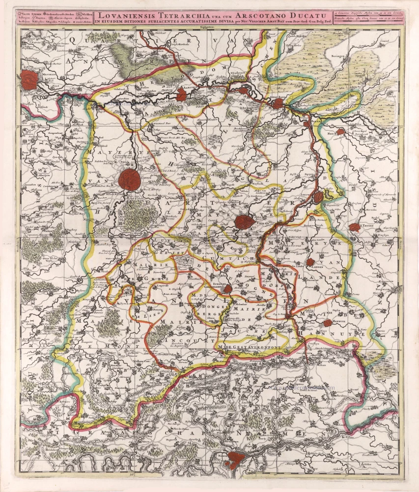
Lovaniensis Tetrarchia una cum Arscotano Ducatu in eiusdem ditiones subiacentes accuratissime divisa. 1683-1696
Leuven - Aarschot by Nicolaas Visscher II.
[Item number: 29591]
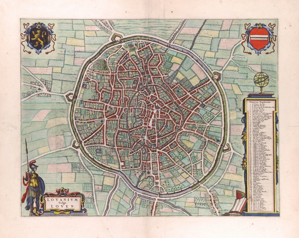
Lovanium vulgo Loven. 1649
Leuven by Joan Blaeu.
[Item number: 29726]

Forêt de Soignes - Zoniën Woud by Willem Blaeu.
Secunda Pars Brabantiae cuius urbs primaria Bruxellae. 1643
Southern Brabant (Brussels) by Willem Blaeu.
[Item number: 29930]
Important plan.
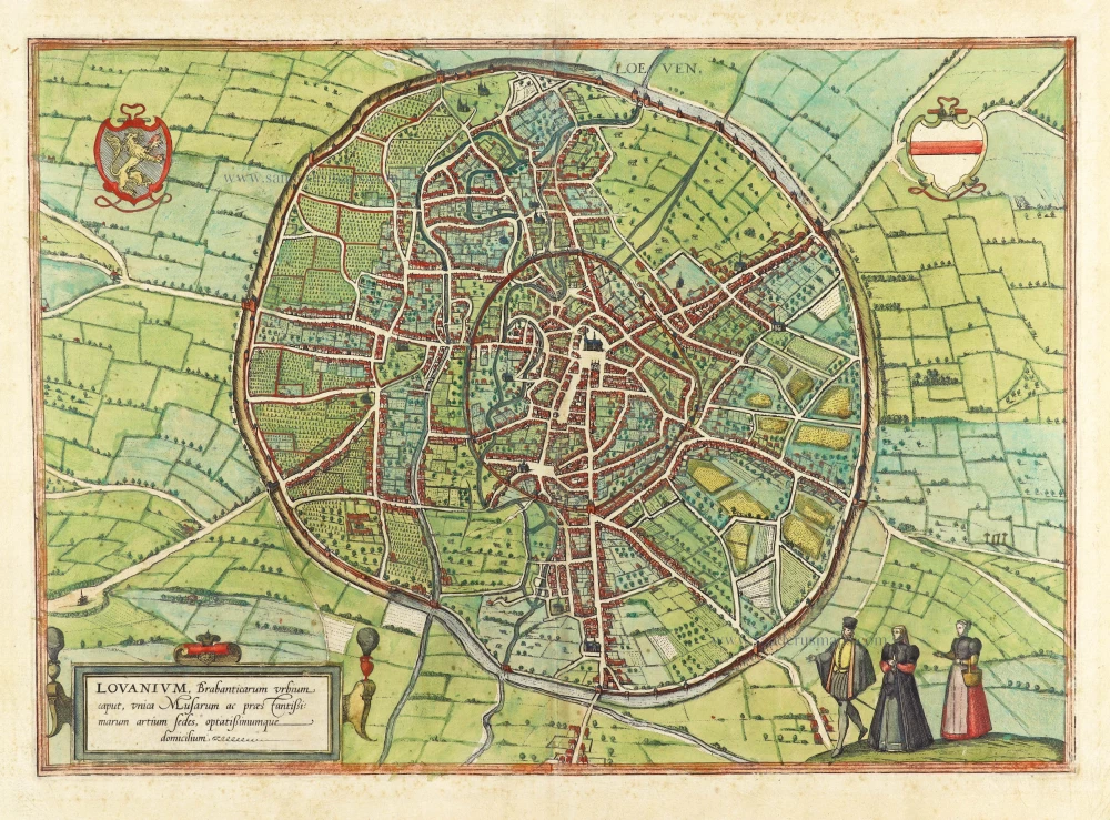
Loeven - Lovanium, Brabanticarum urbium caput, unica Musarum ac praestantissimorum artium sedes, optatissimimque domicilium. 1599
Louvain by Georg Braun & Frans Hogenberg.
[Item number: 29977]
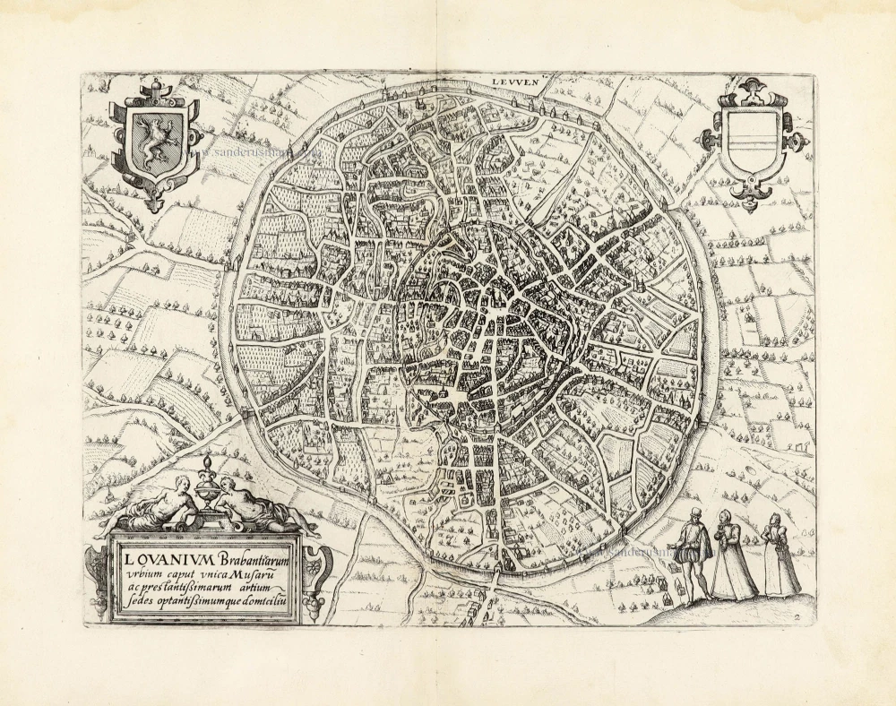
Leuven - Lovanium Brabanticarum urbium caput unica Musaru[m] ac prestantißimarum artium sedes optantißimumque domiciliu[m]. 1609
Leuven by Lodovico Guicciardini.
[Item number: 30081]
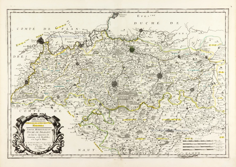
Menapii. Dioecese de l'Archev[es]ché de Malines. Partie meridionale du Duché de Brabant, ou sont les quartiers de Louvain, et du Brusselles; et la seign[eu]rie de Malines. 1679-1710
Historical map of Southern Brabant, by Guillaume Sanson, published by P. Mariette.
[Item number: 30520]

Tabula Ducatus Brabantiae continens Marchionatum Sacri Imperiii et Dominium Mechliniense 1670-71
Brabant by Frederick De Wit.
[Item number: 30526]
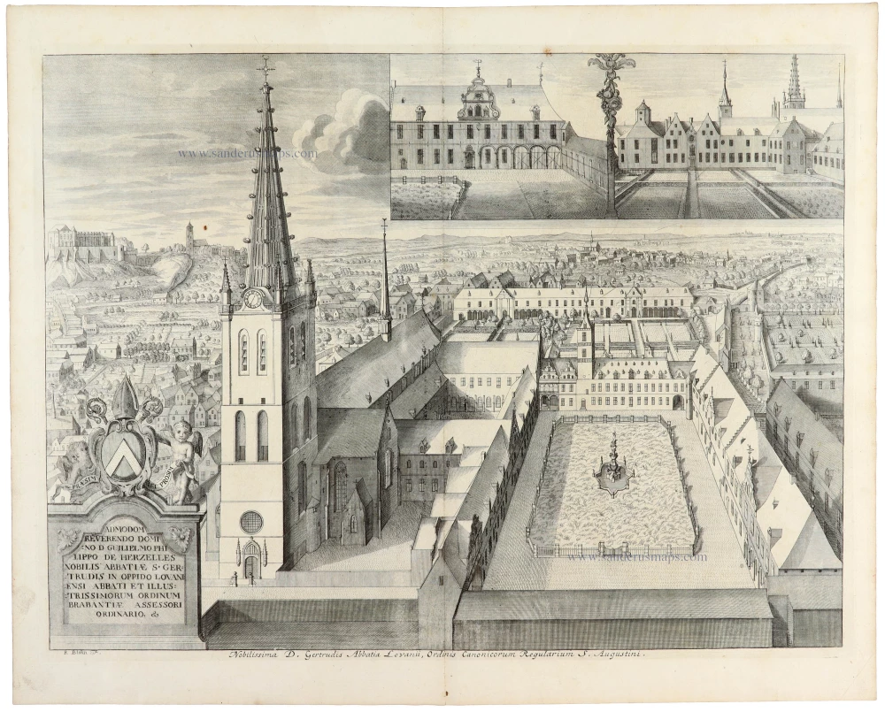
Nobilissima D. Gertrudis Abbatia Lovanii, Ordinis Canonicorum Regularium S. Augustini. 1727
Leuven - St.-Gertrude abdij by Antonius Sanderus.
[Item number: 30680]