
Very decorative
Petrus Kaerius (Pieter Van den Keere), Leo Belgicus. 1622


Second state (only two copies were recorded for the first state). In the reverse text of the 1617-a edition, Kaerius acknowledges the adaptation of the lion from Von Aitzing: "typographicam Leonis Belgici primus in lucem edidit D. Michael Aitsingerius Austriacus" ("The Austrian Michael von Aitzing first published this representation of the Leo Belgicus").
The Netherlands, depicted as a lion, originated with the Austrian Michael von Aitzing (c. 1530-98), who inserted in his book De Leone Belgico (1583) a Leo Belgicus map engraved by Frans Hogenberg. In the preface of this work, von Aitzing explains why he chose this particular title and inserted the lion map. He explains that Caesar mentioned in his "Commentaries" that the 'Belgae' were the strongest tribes. He, therefore, decided - partly because of the religious conflicts in the war against Spain - to introduce the Netherlands as a lion.
Pieter Van den Keere (Petrus Kaerius) (1571-c.1650)
Pieter van den Keere was born in Ghent in 1571 as the son of the type-founder, Hendrik van den Keere. In 1584, he moved with his family to London for religious reasons. There, Van den Keere received training as an engraver from Jodocus Hondius, his brother-in-law. Not only the companionship with Jodocus Hondius but also the acquaintanceship with Pieter van den Berghe (Petrus Montanus), author of the text of the Germania Inferior, originates from the years of refuge in London.
Upon their settlement in Amsterdam in 1593, both Keere and Hondius embarked on a monumental project. Their collaboration resulted in the creation of a large wall map of Europe, a masterpiece that still stands as a testament to their skill and vision, dated 1595: Nova totius Europae descriptio.
In 1610, he set up a workshop in the Kalverstraat that he called ‘In den onseeckeren tijd’ (In the uncertain time). During this period, he made numerous copperplates, including maps for his Atlas of the Netherlands and the Atlas Minor published by Jodocus Hondius.
The Germania Inferior (1617) is the first original atlas of the Netherlands published in folio size. The text for the atlas, both in Dutch and in French, was written by Petrus Montanus. After 1623, Claes Jansz. Visscher bought the plates and substituted his name for Kaerius’s. In 1634, Visscher included many of these maps in his Germana Inferior.
Kaerius's fame is not only based on his atlas of the Netherlands. He is even better known as an engraver of many loose-leaf maps and as a collaborator of book publishers. His maps are found, i.e., in the Caert thresoor (Barent Langenes, 1598), Licht der Zeevaert (Blaeu, 1608), Atlas Minor (Hondius, 1628), and Caertboeck vande Midellandsche Zee (Barents, 1595).
Leo Belgicus.
Item Number: 28462 Authenticity Guarantee
Category: Antique maps > Europe > Belgium
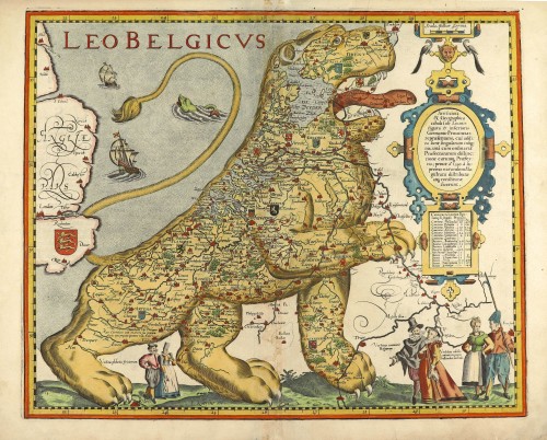
Old, antique map, Leo Belgicus by Petrus Kaerius (Pieter Van den Keere).
Title: Leo Belgicus.
Artifiosa & Geographica tabula sub Leonis figura 17, inferioris Germaniae Provincias repraesentans, cui addita suntsingularum insignia, unà cum ordinaria Praefectuarum distinctione earumque Praefectis prout a° 1559. à supremo earundem Magistratu distributae atque constitutae fuerunt.
P. Kaerius ex.
Engraver: Hendrik Floris van Langren.
Date of the first edition: Before 1609.
Date of first atlas edition: 1617.
Date of this map: 1622.
Copper engraving, printed on paper.
Map size: 372 x 452mm (14.65 x 17.8 inches).
Sheet size: 395 x 515mm (15.55 x 20.28 inches).
Verso: Latin text.
Condition: Original coloured, centrefold reinforced.
Condition Rating: A
References: Van der Krogt 3, 3000:364B; Van der Heijden, 4.2 b; Schilder 8, #21.29
From: Petri Kaerii Germania Inferior id est, XVII provinciarum ejus novae et exactae Tabulae Geographicae, cum Luculentis Singularum descriptionibus additis. Amsterdam, 1622. (Koeman, Kee2; Van der Krogt 3, 64:02)
Second state (only two copies were recorded for the first state). In the reverse text of the 1617-a edition, Kaerius acknowledges the adaptation of the lion from Von Aitzing: "typographicam Leonis Belgici primus in lucem edidit D. Michael Aitsingerius Austriacus" ("The Austrian Michael von Aitzing first published this representation of the Leo Belgicus").
The Netherlands, depicted as a lion, originated with the Austrian Michael von Aitzing (c. 1530-98), who inserted in his book De Leone Belgico (1583) a Leo Belgicus map engraved by Frans Hogenberg. In the preface of this work, von Aitzing explains why he chose this particular title and inserted the lion map. He explains that Caesar mentioned in his "Commentaries" that the 'Belgae' were the strongest tribes. He, therefore, decided - partly because of the religious conflicts in the war against Spain - to introduce the Netherlands as a lion.
Pieter Van den Keere (Petrus Kaerius) (1571-c.1650)
Pieter van den Keere was born in Ghent in 1571 as the son of the type-founder, Hendrik van den Keere. In 1584, he moved with his family to London for religious reasons. There, Van den Keere received training as an engraver from Jodocus Hondius, his brother-in-law. Not only the companionship with Jodocus Hondius but also the acquaintanceship with Pieter van den Berghe (Petrus Montanus), author of the text of the Germania Inferior, originates from the years of refuge in London.
Upon their settlement in Amsterdam in 1593, both Keere and Hondius embarked on a monumental project. Their collaboration resulted in the creation of a large wall map of Europe, a masterpiece that still stands as a testament to their skill and vision, dated 1595: Nova totius Europae descriptio.
In 1610, he set up a workshop in the Kalverstraat that he called ‘In den onseeckeren tijd’ (In the uncertain time). During this period, he made numerous copperplates, including maps for his Atlas of the Netherlands and the Atlas Minor published by Jodocus Hondius.
The Germania Inferior (1617) is the first original atlas of the Netherlands published in folio size. The text for the atlas, both in Dutch and in French, was written by Petrus Montanus. After 1623, Claes Jansz. Visscher bought the plates and substituted his name for Kaerius’s. In 1634, Visscher included many of these maps in his Germana Inferior.
Kaerius's fame is not only based on his atlas of the Netherlands. He is even better known as an engraver of many loose-leaf maps and as a collaborator of book publishers. His maps are found, i.e., in the Caert thresoor (Barent Langenes, 1598), Licht der Zeevaert (Blaeu, 1608), Atlas Minor (Hondius, 1628), and Caertboeck vande Midellandsche Zee (Barents, 1595).
Related items
Belgii Veteris Typus. 1658
Ancient Netherlands by Janssonius J.
[Item number: 83]
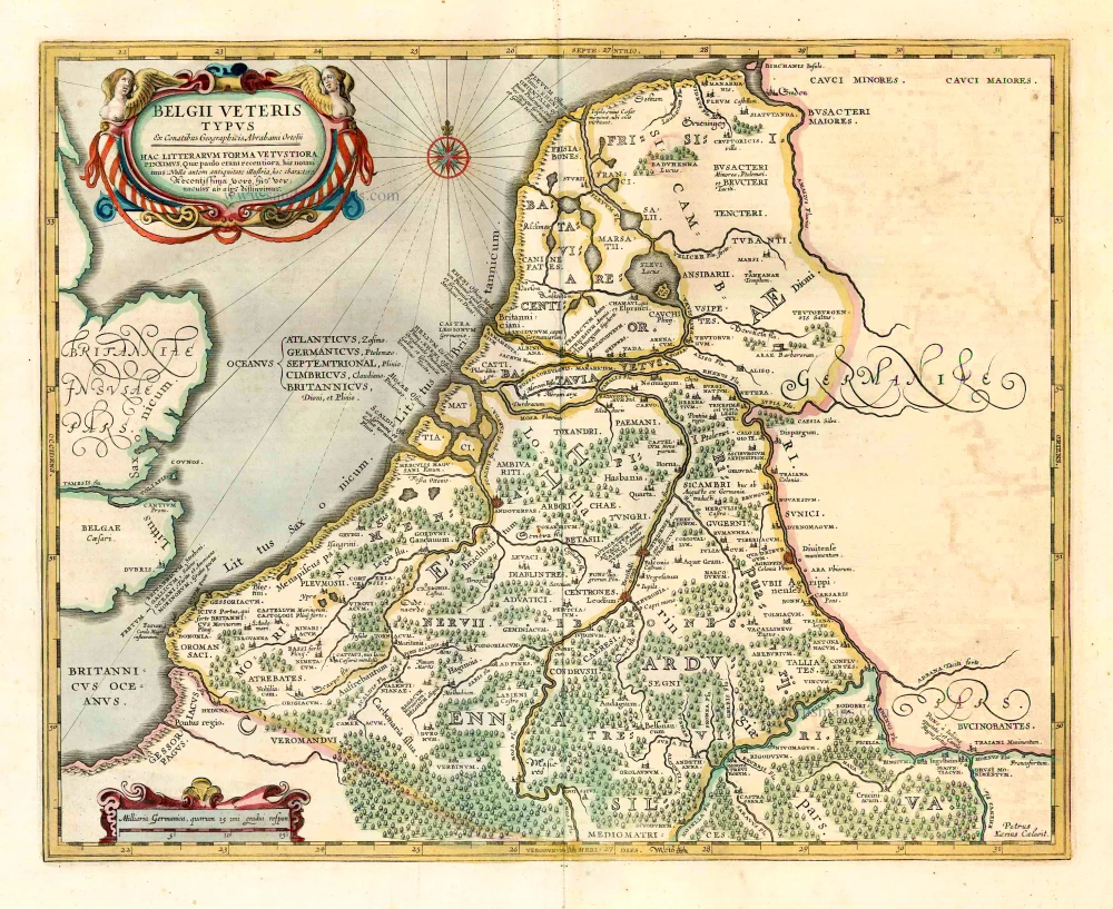
Belgii Veteris Typus. 1601
The ancient Low Countries, by Abraham Ortelius.
[Item number: 12355]
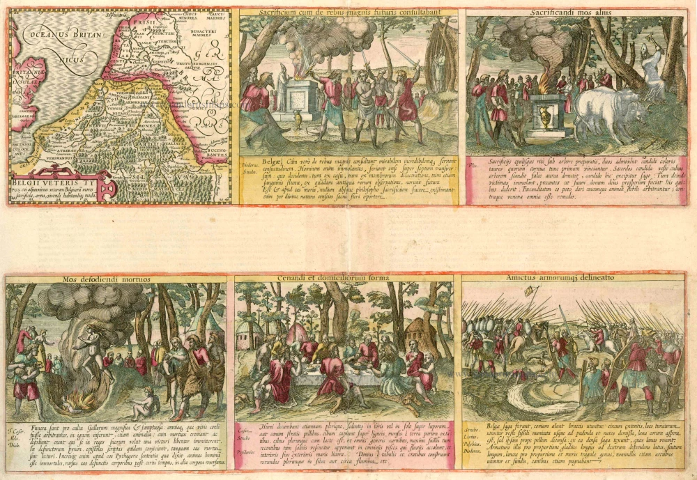
Belgii Veteris Typus cui adjunximus veterum Belgocorum mores sacrificua, arma, vivendi habitandiq. modum. 1617
Low Countries (Ancient) by Kaerius (Van den Keere) P
[Item number: 13664]

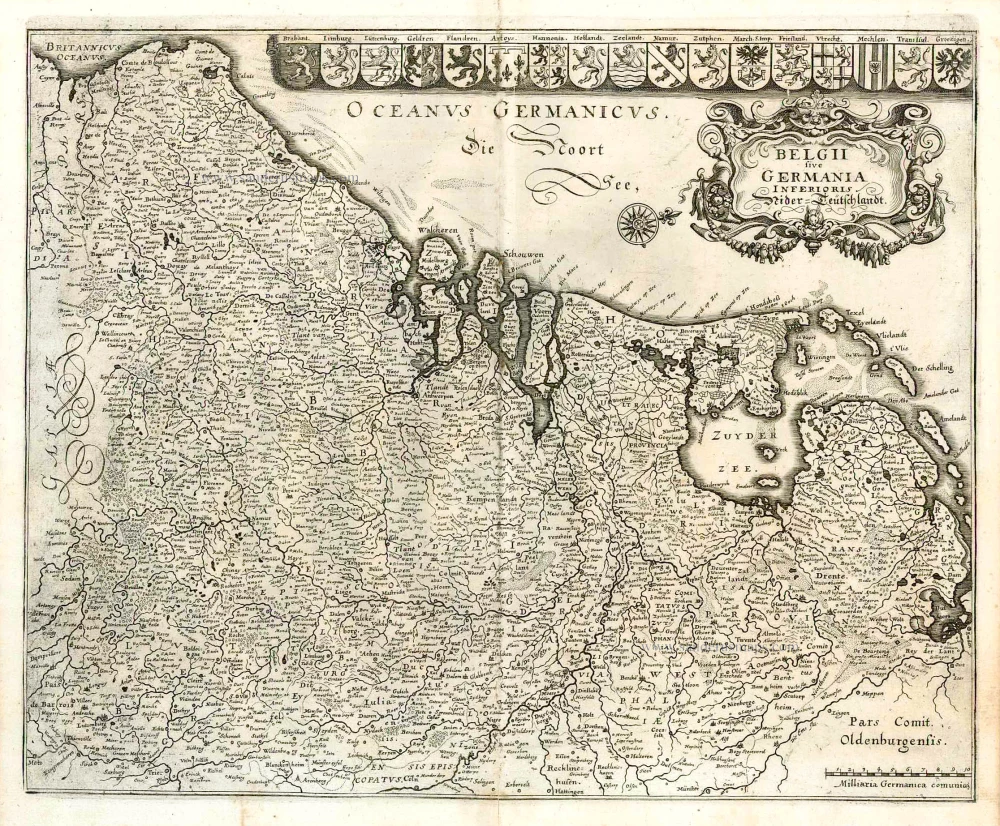
Belgiae Inferioris descriptio emendata cum circu(m)jacentium regionum confinijs. 1610
The 17 Provinces, by Jan Orlers.
[Item number: 25913]
Belgii sive Germania Inferioris - Nider Teutschlandt. 1638
The 17 Provinces, by Matthäus Merian.
[Item number: 26030]
Belgii Veteris Typus. 1641
Ancient Low Countries, by Henricus Hondius.
[Item number: 26300]
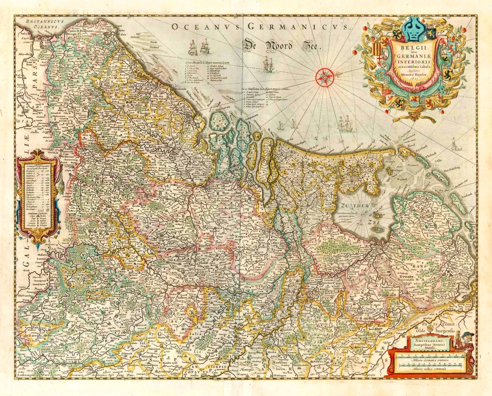
Belgii sive germaniae inferioris accuratissima tabula. auctore henrico hondio 1631. amstelodami, sumptibus henrici hondio 1631. 1641
The 17 Provinces, by Henricus Hondius.
[Item number: 26301]
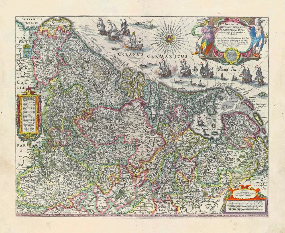
Novus XVII Inferioris Germaniae Provinciarum Typus. 1631
17 Provinces, by Willem Blaeu.
[Item number: 28019]
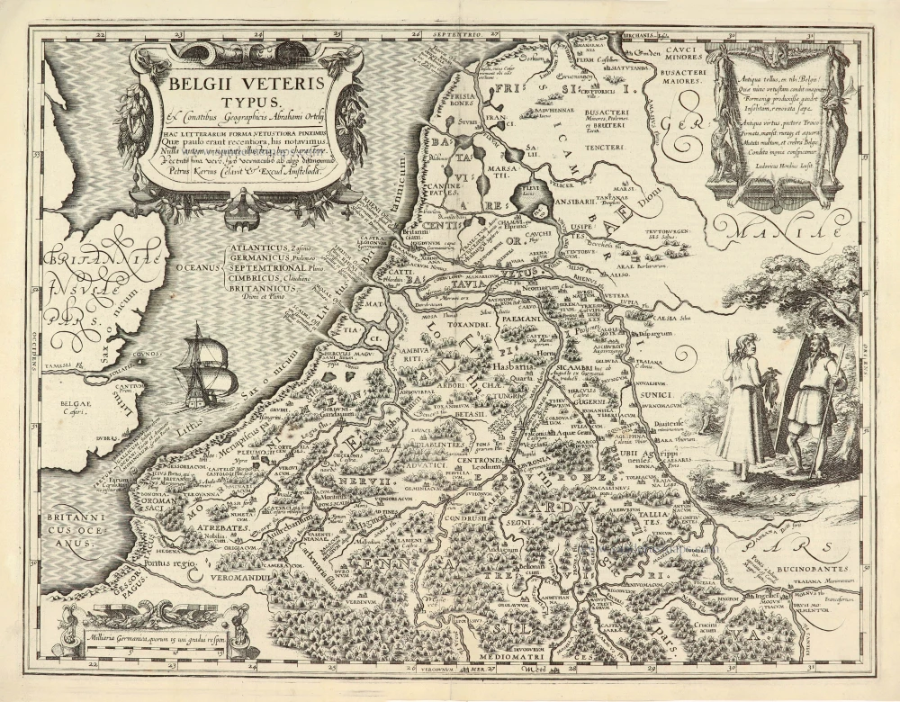
Belgii Veteris Typus. 1617
Ancient Low Countries, by Petrus Kaerius (Pieter Van den Keere).
[Item number: 28069]
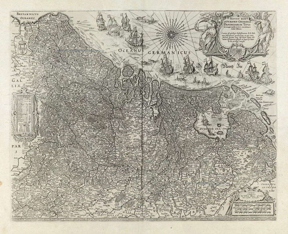
Novus XVII Inferioris Germaniae Provinciarum Typus. 1664-65
17 Provinces, by Willem Blaeu.
[Item number: 28110]
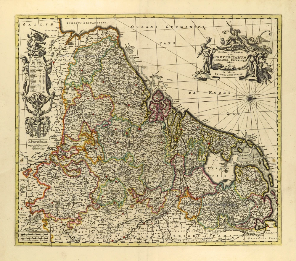
Novissima et accuratissima XVII provinciarum Germaniae Inferioris Tabula. c. 1715
17 Provinces, by Frederik de Wit, published by Covens & Mortier.
[Item number: 28284]