
The Sound with Helsingborg, Landskrona and Elbogen, by Georg Braun and Frans Hogenberg. 1590
The item displayed on this page has been sold. However, we have a similar map in stock:
Sound Strait by Braun and Hogenberg 1635
Freti Danici or Sundt Accuratiss Delineatio.
[Item number: 32690]
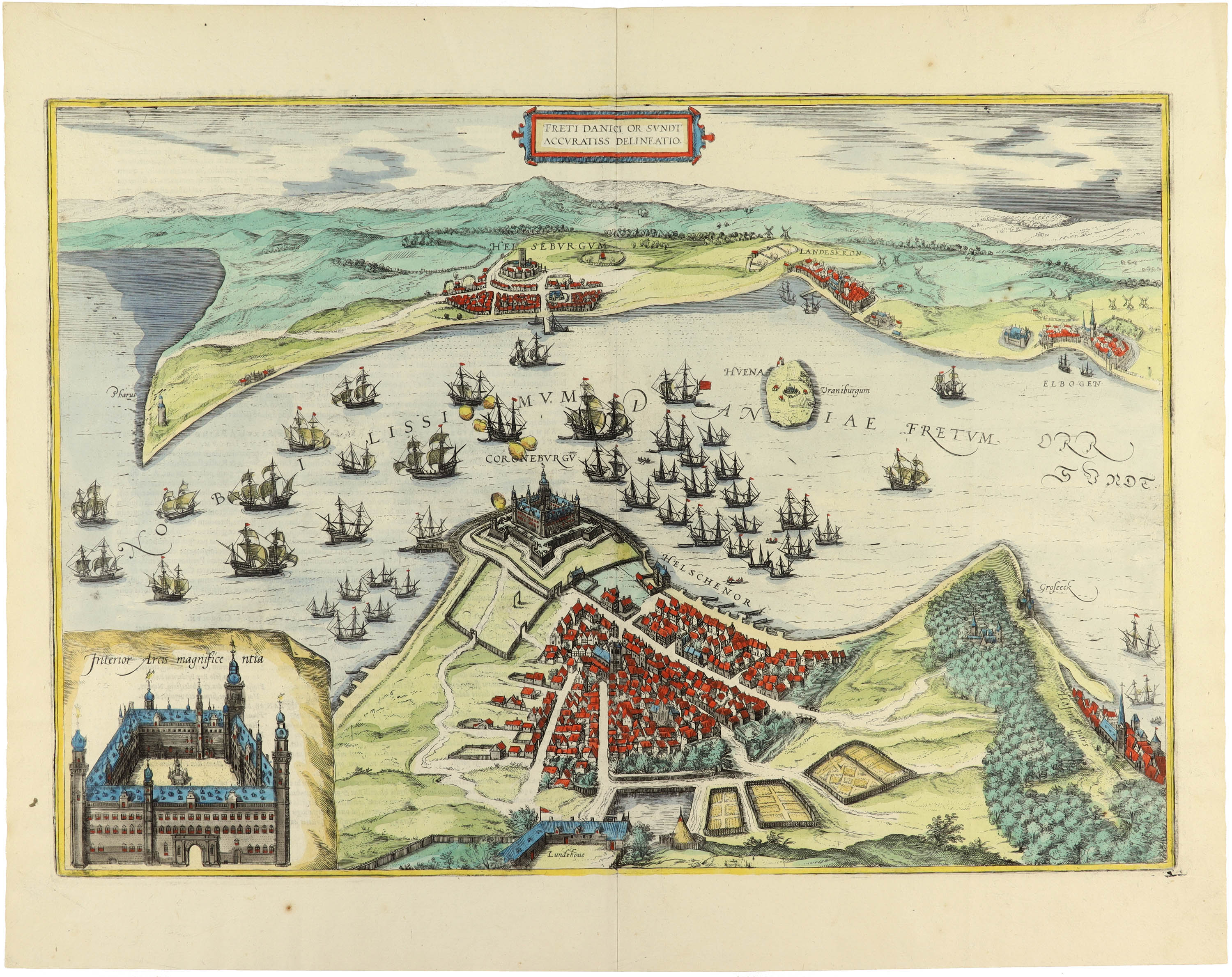


Translation of cartouche text: Accurate drawing of the Danish strait or sound.
COMMENTARY BY BRAUN (on verso): "At this place, the islands of Zealand and Scania, with foothills rising on both sides, lie so close to each other that there is scarcely one mile between them. Through this strait, called Oresund, many rivers from Germany, Livonia, Sweden and Russia, which have entered the Baltic Sea, rush past due to a difference in altitude into the great sea between Jutland, Denmark and Norway. All ships that pass through the sound must stop at this place to pay their respects to the castle as the royal residence by lowering their sails and paying customs dues on their cargo to the royal treasurer."
This bird's-eye view from the west demonstratively presents the sound as a Danish inland sea to counter the Swedish claims. The cities of Helsingborg, Landskrona and Malmö, Danish at the time, and the Island of Ven can be seen. In the foreground is the city of Helsingor with its late Gothic cathedral of St Olai, completed in the 15th century. A sea battle occurs in the sound, and Kronborg castle is under attack. This was a strategically important fortress, where the Sound Toll was collected from passing non-Danish ships. Kronborg castle entered world literature around 1600 as the scene of Shakespeare's play Hamlet, Prince of Denmark. (Taschen)
Braun G. & Hogenberg F. and the Civitates Orbis Terrarum.
The Civitates Orbis Terrarum, also known as the 'Braun & Hogenberg', is a six-volume town atlas and the most excellent book of town views and plans ever published: 363 engravings, sometimes beautifully coloured. It was one of the best-selling works in the last quarter of the 16th century. Georg Braun, a skilled writer, wrote the text accompanying the plans and views on the verso. Many plates were engraved after the original drawings of a professional artist, Joris Hoefnagel (1542-1600). The first volume was published in Latin in 1572 and the sixth in 1617. Frans Hogenberg, a talented engraver, created the tables for volumes I through IV, and Simon van den Neuwel made those for volumes V and VI. Other contributors were cartographers Daniel Freese and Heinrich Rantzau, who provided valuable geographical information. Works by Jacob van Deventer, Sebastian Münster, and Johannes Stumpf were also used as references. Translations appeared in German and French, making the atlas accessible to a broader audience.
Since its original publication of volume 1 in 1572, the Civitates Orbis Terrarum has left an indelible mark on the history of cartography. Seven more editions followed the first volume in 1575, 1577, 1582, 1588, 1593, 1599, and 1612. Vol.2, initially released in 1575, saw subsequent editions in 1597 and 1612. The subsequent volumes, each a treasure trove of historical insights, graced the world in 1581, 1588, 1593, 1599, and 1606. The German translation of the first volume, a testament to its widespread appeal, debuted in 1574, followed by the French edition in 1575.
Several printers were involved: Theodor Graminaeus, Heinrich von Aich, Gottfried von Kempen, Johannis Sinniger, Bertram Buchholtz, and Peter von Brachel, all of whom worked in Cologne.
Georg Braun (1541-1622)
Georg Braun, the author of the text accompanying the plans and views in the Civitates Orbis Terrarum, was born in Cologne in 1541. After his studies in Cologne, he entered the Jesuit Order as a novice, indicating his commitment to learning and intellectual pursuits. In 1561, he obtained his bachelor's degree; in 1562, he received his Magister Artium, further demonstrating his academic achievements. Although he left the Jesuit Order, he continued his studies in theology, gaining a licentiate in theology. His theological background likely influenced the content and tone of the text in the Civitates Orbis Terrarum, adding a unique perspective to the work.
Frans Hogenberg (1535-1590)
Frans Hogenberg was a Flemish and German painter, engraver, and mapmaker. He was born in Mechelen as the son of Nicolaas Hogenberg.
By the end of the 1560s, Frans Hogenberg was employed upon Abraham Ortelius's Theatrum Orbis Terrarum, published in 1570; he is named an engraver of numerous maps. In 1568, he was banned from Antwerp by the Duke of Alva and travelled to London, where he stayed a few years before emigrating to Cologne. He immediately embarked on his two most important works, the Civitates, published in 1572 and the Geschichtsblätter, which appeared in several series from 1569 until about 1587.
Thanks to large-scale projects like the Geschichtsblätter and the Civitates, Hogenberg's social circumstances improved with each passing year. He died as a wealthy man in Cologne in 1590.
Freti Danici or Sundt Accuratiss Delineatio.
Item Number: 14941 Authenticity Guarantee
Category: Antique maps > Europe > Northern Europe
Old, antique bird’s-eye view plan of The Sound with Helsingborg, Landskrona and Elbogen, by Georg Braun and Frans Hogenberg.
Title: Freti Danici or Sundt Accuratiss Delineatio.
Date of the first edition: 1588.
Date of this map: 1590.
Copper engraving, printed on paper.
Size (not including margins): 340 x 470mm (13.39 x 18.5 inches).
Verso: German text.
Condition: Old coloured, lower centrefold split reinforced, else good.
Condition Rating: A.
Translation of cartouche text: Accurate drawing of the Danish strait or sound.
COMMENTARY BY BRAUN (on verso): "At this place, the islands of Zealand and Scania, with foothills rising on both sides, lie so close to each other that there is scarcely one mile between them. Through this strait, called Oresund, many rivers from Germany, Livonia, Sweden and Russia, which have entered the Baltic Sea, rush past due to a difference in altitude into the great sea between Jutland, Denmark and Norway. All ships that pass through the sound must stop at this place to pay their respects to the castle as the royal residence by lowering their sails and paying customs dues on their cargo to the royal treasurer."
This bird's-eye view from the west demonstratively presents the sound as a Danish inland sea to counter the Swedish claims. The cities of Helsingborg, Landskrona and Malmö, Danish at the time, and the Island of Ven can be seen. In the foreground is the city of Helsingor with its late Gothic cathedral of St Olai, completed in the 15th century. A sea battle occurs in the sound, and Kronborg castle is under attack. This was a strategically important fortress, where the Sound Toll was collected from passing non-Danish ships. Kronborg castle entered world literature around 1600 as the scene of Shakespeare's play Hamlet, Prince of Denmark. (Taschen)
Braun G. & Hogenberg F. and the Civitates Orbis Terrarum.
The Civitates Orbis Terrarum, also known as the 'Braun & Hogenberg', is a six-volume town atlas and the most excellent book of town views and plans ever published: 363 engravings, sometimes beautifully coloured. It was one of the best-selling works in the last quarter of the 16th century. Georg Braun, a skilled writer, wrote the text accompanying the plans and views on the verso. Many plates were engraved after the original drawings of a professional artist, Joris Hoefnagel (1542-1600). The first volume was published in Latin in 1572 and the sixth in 1617. Frans Hogenberg, a talented engraver, created the tables for volumes I through IV, and Simon van den Neuwel made those for volumes V and VI. Other contributors were cartographers Daniel Freese and Heinrich Rantzau, who provided valuable geographical information. Works by Jacob van Deventer, Sebastian Münster, and Johannes Stumpf were also used as references. Translations appeared in German and French, making the atlas accessible to a broader audience.
Since its original publication of volume 1 in 1572, the Civitates Orbis Terrarum has left an indelible mark on the history of cartography. Seven more editions followed the first volume in 1575, 1577, 1582, 1588, 1593, 1599, and 1612. Vol.2, initially released in 1575, saw subsequent editions in 1597 and 1612. The subsequent volumes, each a treasure trove of historical insights, graced the world in 1581, 1588, 1593, 1599, and 1606. The German translation of the first volume, a testament to its widespread appeal, debuted in 1574, followed by the French edition in 1575.
Several printers were involved: Theodor Graminaeus, Heinrich von Aich, Gottfried von Kempen, Johannis Sinniger, Bertram Buchholtz, and Peter von Brachel, all of whom worked in Cologne.
Georg Braun (1541-1622)
Georg Braun, the author of the text accompanying the plans and views in the Civitates Orbis Terrarum, was born in Cologne in 1541. After his studies in Cologne, he entered the Jesuit Order as a novice, indicating his commitment to learning and intellectual pursuits. In 1561, he obtained his bachelor's degree; in 1562, he received his Magister Artium, further demonstrating his academic achievements. Although he left the Jesuit Order, he continued his studies in theology, gaining a licentiate in theology. His theological background likely influenced the content and tone of the text in the Civitates Orbis Terrarum, adding a unique perspective to the work.
Frans Hogenberg (1535-1590)
Frans Hogenberg was a Flemish and German painter, engraver, and mapmaker. He was born in Mechelen as the son of Nicolaas Hogenberg.
By the end of the 1560s, Frans Hogenberg was employed upon Abraham Ortelius's Theatrum Orbis Terrarum, published in 1570; he is named an engraver of numerous maps. In 1568, he was banned from Antwerp by the Duke of Alva and travelled to London, where he stayed a few years before emigrating to Cologne. He immediately embarked on his two most important works, the Civitates, published in 1572 and the Geschichtsblätter, which appeared in several series from 1569 until about 1587.
Thanks to large-scale projects like the Geschichtsblätter and the Civitates, Hogenberg's social circumstances improved with each passing year. He died as a wealthy man in Cologne in 1590.
Related items

Caarte van 't gat van Abbo, ofte Uttoy. [on sheet with] Caarte van 't Stochomse Liet. 1686
Sea chart of Finland - Sweden, by Doncker H.
[Item number: 14593]

Colding Schloss und Stat c. 1610
Kolding, by Georg Braun and Frans Hogenberg.
[Item number: 16693]

Civitates Episcopalis Othenarum sive Otthoniae, ut vulgo Dicitur, Fioniae ... c. 1610
Odense, by Georg Braun and Frans Hogenberg.
[Item number: 16703]
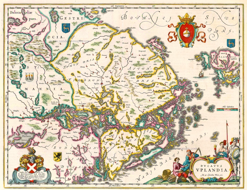
Ducatus Uplandia 1644
Uppland (Sweden), by Joan Blaeu.
[Item number: 21398]
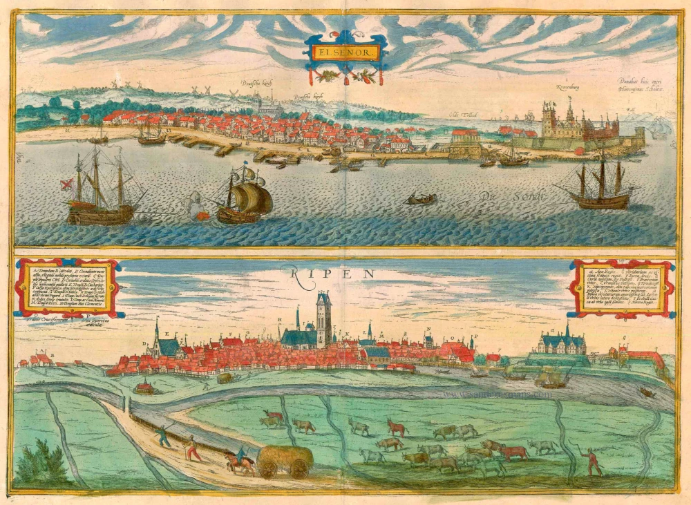
Elsenor [on sheet with] Ripen 1596-1640
Helsingør (Sjaelland) & Ribe (Jutland), by Georg Braun and Frans Hogenberg.
[Item number: 23375]
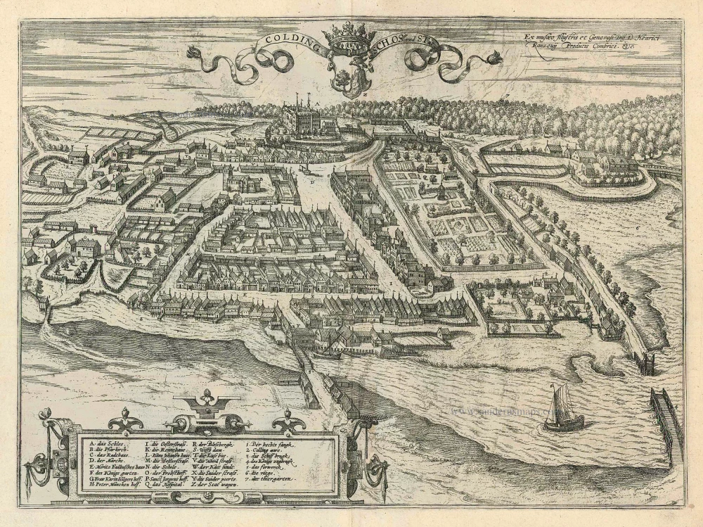
Colding Schloss und Stat 1596
Kolding by Braun and Hogenberg
[Item number: 24163]
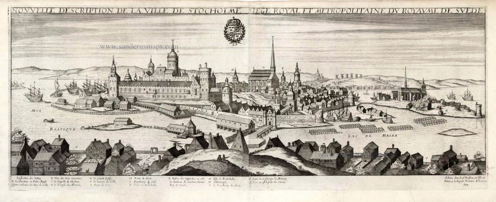
Nouvelle Description de la Ville de Stockholme Siege Royal et Metropolitaine du Royaume de Suede. 1648
Stockholm by Jean Boisseau
[Item number: 25690]
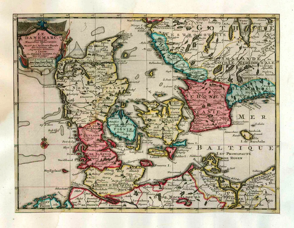
Le Danemarc, Suivant les Nouvelles Observations de Mess.rs de L'Academie Royale des Sciences, etc. 1713
Denmark, by Pieter van der Aa
[Item number: 26044]